
Yu Shan facts for kids
Quick facts for kids Yushan |
|
|---|---|
| Jade Mountain | |

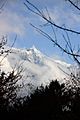
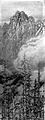
Yushan from the North Peak
|
|
| Highest point | |
| Elevation | 3,952.43 m (12,967.3 ft) |
| Prominence | 3,952.43 m (12,967.3 ft) Ranked 27th |
| Listing | Country high point Ultra 100 Peaks of Taiwan |
| Geography | |

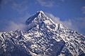
Yushan
Location in Taiwan
|
|
| Location | The border on Taoyuan District, Kaohsiung/ Alishan, Chiayi County/ Xinyi, Nantou County, Taiwan |
| Parent range | Yushan Range |
| Climbing | |
| First ascent | 1898 by German explorer Karl Theodor Stöpel |
| Easiest route | Maintained trail, snow/ice climb during some winter months |
| Yushan | |||||||||||||||||||
|---|---|---|---|---|---|---|---|---|---|---|---|---|---|---|---|---|---|---|---|
| Chinese | 玉山 | ||||||||||||||||||
| Postal | Mount Morrison | ||||||||||||||||||
| Literal meaning | Jade Mountain | ||||||||||||||||||
|
|||||||||||||||||||
| Former names | |||||||||||||||
|---|---|---|---|---|---|---|---|---|---|---|---|---|---|---|---|
| Batongguan | |||||||||||||||
| Traditional Chinese | 八通關 | ||||||||||||||
| Simplified Chinese | 八通关 | ||||||||||||||
| Literal meaning | transcribing the Tsou name Patungkuonʉ | ||||||||||||||
|
|||||||||||||||
| Baiyushan | |||||||||||||||
| Chinese | 白玉山 | ||||||||||||||
| Literal meaning | White Jade Mountain | ||||||||||||||
|
|||||||||||||||
| Xueshan | |||||||||||||||
| Chinese | 雪山 | ||||||||||||||
| Literal meaning | Snowy Mountain | ||||||||||||||
|
|||||||||||||||
| Mugangshan | |||||||||||||||
| Traditional Chinese | 木岡山 | ||||||||||||||
| Simplified Chinese | 木冈山 | ||||||||||||||
| Literal meaning | Wooded Mountain | ||||||||||||||
|
|||||||||||||||
| Mount Niitaka | |||||||||
|---|---|---|---|---|---|---|---|---|---|
| Chinese name | |||||||||
| Chinese | 新高山 | ||||||||
| Literal meaning | New High Mountain | ||||||||
|
|||||||||
| Japanese name | |||||||||
| Kanji | 新高山 | ||||||||
| Hiragana | にいたかやま | ||||||||
|
|||||||||
Yushan, also called Mount Jade, is the tallest mountain in Taiwan. It stands at about 3,952 meters (12,966 feet) above sea level. This makes Taiwan's highest point the 4th highest for any island in the world. Yushan and the mountains around it are part of the Yushan Range. This area was once under the ocean! It rose up because two giant land plates, the Eurasian Plate and the Philippine Sea Plate, pushed against each other.
Today, Yushan and its nearby mountains are protected as Yushan National Park. This park is Taiwan's largest and highest national park. It's also one of the wildest places left on the island.
Contents
Mountain Names: Yushan's Many Titles
Yushan is the most common name for this mountain. It comes from the Chinese words for "Jade Mountain." People call it this because in winter, when it's covered in thick snow, the peak looks like shiny, white jade. In ancient Chinese stories, "Jade Mountain" was also a magical place. It was said to be the home of the Queen Mother of the West, a powerful goddess.
During the Qing Dynasty, a long time ago, Yushan was known as Mugangshan. This means "Wooded Mountain" because of all the forests around it. Other names included Batongguan and Baiyushan ("White Jade Mountain"). It was also called Xueshan, meaning "Snowy Mountain."
For a while, it was known in English as Mount Morrison. This name came from an American captain who saw the mountain in 1857. It's not named after the famous missionary Robert Morrison, as some people mistakenly thought.
Local native groups also have their own names for the mountain. The Bunun people call it Saviah or Tongku Saveq, which means "highest peak."
When Japan ruled Taiwan, the mountain got a new name: Mount Niitaka. This means "New High Mountain." Why? Because new surveys showed it was 176 meters (577 feet) taller than Mount Fuji in Japan!
How Yushan Was Formed: Geology and Geography


The island of Taiwan sits where two huge tectonic plates meet. These are the Eurasian Plate and the Philippine Sea Plate. Millions of years ago, this land was just a seabed covered in mud and sand.
As the two plates slowly pushed against each other, the land began to fold and bend. This process created the amazing landscape we see today. Taiwan, a relatively small island, has 165 mountains that are taller than 3,000 meters (9,843 feet) above sea level!
Yushan is special because it's the highest point on the Tropic of Cancer. It's also the only place on this line where there's proof of ice caps from the past. About 17,000 years ago, permanent ice caps covered Taiwan's highest mountains. They reached down to about 2,800 meters (9,186 feet). Today, the closest glaciers to the Tropic of Cancer are far away in Mexico.
The ocean waters off Taiwan's east coast are very deep. The seabed drops sharply down to the Pacific Ocean, reaching depths of over 4,000 meters (13,123 feet) just 50 kilometers (31 miles) from the coast.
Hiking Yushan: Trails and Peaks
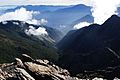
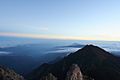
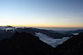
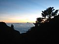
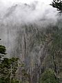
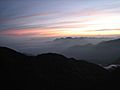
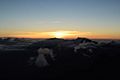
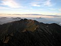
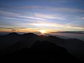
Yushan National Park is famous for its stunning views. You can see mountains stretching far away, deep valleys, beautiful sunrises and sunsets, and even clouds from above! Often, a "Sea of clouds" fills the valleys, looking like a fluffy white ocean. Yushan itself is the main attraction of the park.
Yushan is a favorite mountain for Taiwanese mountain climbers. It's also a popular goal for international hikers. Yushan is ranked as the 4th highest island peak in the world and the 3rd highest in Asia. Many hikers aim to climb Yushan, along with Puncak Jaya in Indonesia and Mount Kinabalu in Malaysia, as part of an "Asian Trilogy" hiking challenge.
Yushan has five main peaks. The Main Peak is the most popular one to climb:
- Main Peak (玉山主峰): 3,952 meters (12,966 feet)
- Eastern Peak (玉山東峰): 3,869 meters (12,694 feet) – about 1.2 kilometers (0.75 miles) from the Main Peak.
- Northern Peak (玉山北峰): 3,858 meters (12,657 feet) – about 2.2 kilometers (1.4 miles) from "Wind Tunnel" (風口).
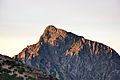
- Southern Peak (玉山南峰): 3,844 meters (12,612 feet) – about 3.1 kilometers (1.9 miles) from "Paiyun Lodge" (排雲山莊).
- Western Peak (玉山西峰): 3,467 meters (11,375 feet) – about 4 kilometers (2.5 miles) from "Paiyun Lodge" (排雲山莊).
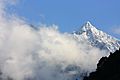
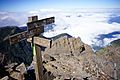
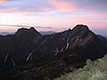
The East, West, North, and South peaks surround the main summit. The East Peak is considered one of Taiwan's Ten Major Summits. The South Peak is a sharp, black rock spire. The western side of Yushan is easier to access and covered with thick forests. The North Peak has two high points that look like a camel's humps. It's also home to Taiwan's highest building that is always occupied: the Yushan Weather Station. Visitors there are usually welcomed warmly.
-
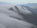
Sea of Clouds at Yushan
-
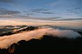
Sunrise at Yushan
-
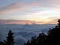
Sea of Clouds on Yushan Trail


Plants and Animals: Yushan's Rich Wildlife

-PeterWen-6.jpg)
Taiwan is located near the tropic of Cancer, which means it has a mix of tropical and subtropical climates. The average temperature is around 23.5°C (74.3°F). In lower areas, you'll find evergreen forests with broad leaves. As you go higher up the mountain, these forests change. They become deciduous forests (trees that lose their leaves) and then coniferous forests (trees with needles, like pines). At the very top, where it's cold and windy, you'll mostly see mosses, liverworts, and some grasses.
All these different types of plants can be found in the Yushan area. This is because the elevation changes a lot, by about 3.6 kilometers (2.2 miles). These wide changes in climate and plants create a home for the richest and most diverse wildlife in Taiwan.
Scientists have found many different animals in Yushan National Park. There are 130 types of birds, 28 types of mammals, 17 types of reptiles, 12 types of amphibians, and 186 types of butterflies. Yushan is sometimes called "the ark" by experts. This means it's like a safe place for many of Taiwan's rare species. It's like a living encyclopedia of Taiwan's ecological systems. It's also an important home for about one-third of Taiwan's unique species, which are found nowhere else in the world.
Some of these special animals include:
- Formosan serow (台灣長鬃山羊)
- Reeves's muntjac (台灣山羌)
- Formosan black bear (台灣黑熊)
- Formosan blue magpie (台灣藍鵲)
- Formosan rock macaque (台灣獼猴)
- Two unique fish species, Hemimyzon taitungensis and Varicorhinus tamusuiensis, live in the Lekuleku River area.
Yushan's Place in History
In 1857, W. Morrison, a captain of an American ship, saw the mountain from Anping Harbor. His notes were the first time a Westerner mentioned the mountain. That's how it got the name "Mount Morrison" in European maps. At that time, it was hard for European climbers to reach the mountain. This was because local native groups were not friendly with either the Qing government or Europeans.
When the Japanese ruled Taiwan, two anthropologists, Torii Ryūzō and Ushinosuke Mori, were the first people recorded to climb the mountain in 1900. They named it "Mount Niitaka." This name was later used for the Niitaka Arisan National Park in 1937.
The Imperial Japanese Navy even used the mountain's name in a secret signal! The signal was NIITAKAYAMANOBORE 1208, which means "Climb Mount Niitaka 1208." This signal was given to start the surprise attack on the USN fleet at Pearl Harbor in Hawaii on December 7, 1941. The "1208" meant December 8th in the Japanese calendar.
The Yushan weather station on the north peak was finished in 1943.
After the Republic of China took over, a large bronze statue of Yu Youren was placed on the Yushan summit in 1966. However, in 1996, activists who wanted Taiwan to be independent cut down the statue and threw it into a ravine.
In recent years, Yushan has become a very important symbol for Taiwan's identity. Because it's so iconic, Yushan was chosen to be on the back of the new NT$1,000 banknotes issued on July 20, 2005. Also, a new asteroid found by the Lulin Observatory was named after Yushan on December 28, 2007.
Yushan's Weather: Climate and Seasons
Yushan has an alpine climate, which means it's like the climate found in high mountains. The very top of Yushan is usually covered with frost from November to March. Places higher than 2,000 meters (6,562 feet) might see snow during winter. At elevations above 3,000 meters (9,843 feet), snow can stay on the ground for four months in a row. The first snow can appear in October and usually melts completely by May. On average, snow falls about 24.3 days each year on Yushan, but this number is slowly getting smaller.
Yushan gets about 3,100 millimeters (122 inches) of rain every year. It rains about 140 days a year, mostly between May and August. From May until early June is the plum rain season or monsoon season. Taiwan's typhoon season is usually between July and September. August is the wettest month, with about 520 millimeters (20 inches) of rain on average. December is the driest month, with only about 70 millimeters (2.8 inches) of rain.
| Climate data for Yushan (1991–2020 normals, extremes 1943–present) | |||||||||||||
|---|---|---|---|---|---|---|---|---|---|---|---|---|---|
| Month | Jan | Feb | Mar | Apr | May | Jun | Jul | Aug | Sep | Oct | Nov | Dec | Year |
| Record high °C (°F) | 18.9 (66.0) |
23.4 (74.1) |
20.9 (69.6) |
23.2 (73.8) |
24.8 (76.6) |
26.2 (79.2) |
23.8 (74.8) |
22.0 (71.6) |
23.6 (74.5) |
23.2 (73.8) |
20.2 (68.4) |
16.8 (62.2) |
26.2 (79.2) |
| Mean daily maximum °C (°F) | 4.6 (40.3) |
4.5 (40.1) |
6.4 (43.5) |
8.7 (47.7) |
11.2 (52.2) |
12.9 (55.2) |
14.4 (57.9) |
14.0 (57.2) |
14.0 (57.2) |
13.9 (57.0) |
10.6 (51.1) |
6.7 (44.1) |
10.2 (50.4) |
| Daily mean °C (°F) | −0.5 (31.1) |
−0.2 (31.6) |
1.4 (34.5) |
3.6 (38.5) |
6.0 (42.8) |
7.4 (45.3) |
8.0 (46.4) |
7.8 (46.0) |
7.4 (45.3) |
6.6 (43.9) |
4.1 (39.4) |
1.2 (34.2) |
4.4 (39.9) |
| Mean daily minimum °C (°F) | −4.0 (24.8) |
−3.4 (25.9) |
−1.7 (28.9) |
0.6 (33.1) |
3.0 (37.4) |
4.5 (40.1) |
4.6 (40.3) |
4.6 (40.3) |
4.1 (39.4) |
2.8 (37.0) |
0.7 (33.3) |
−2.1 (28.2) |
1.1 (34.0) |
| Record low °C (°F) | −18.4 (−1.1) |
−14.8 (5.4) |
−15.2 (4.6) |
−10.1 (13.8) |
−3.9 (25.0) |
−1.9 (28.6) |
−3.2 (26.2) |
−0.4 (31.3) |
−2.4 (27.7) |
−5.5 (22.1) |
−10.6 (12.9) |
−15.0 (5.0) |
−18.4 (−1.1) |
| Average precipitation mm (inches) | 83.7 (3.30) |
67.2 (2.65) |
94.8 (3.73) |
201.2 (7.92) |
423.6 (16.68) |
459.6 (18.09) |
434.2 (17.09) |
516.0 (20.31) |
297.2 (11.70) |
145.1 (5.71) |
98.3 (3.87) |
81.6 (3.21) |
2,902.5 (114.27) |
| Average precipitation days (≥ 0.1 mm) | 6.8 | 6.9 | 7.8 | 13.1 | 18.7 | 18.0 | 18.1 | 18.4 | 14.4 | 10.1 | 8.2 | 6.5 | 147.0 |
| Average relative humidity (%) | 62.3 | 70.7 | 76.2 | 80.0 | 81.5 | 80.8 | 77.7 | 81.0 | 77.4 | 66.4 | 65.9 | 63.1 | 73.6 |
| Mean monthly sunshine hours | 207.0 | 158.7 | 151.0 | 139.4 | 133.8 | 135.9 | 171.3 | 150.8 | 158.5 | 213.6 | 199.7 | 197.1 | 2,016.8 |
| Percent possible sunshine | 62 | 51 | 41 | 37 | 33 | 34 | 42 | 38 | 44 | 60 | 61 | 60 | 46 |
| Source: Central Weather Bureau | |||||||||||||
Images for kids
-
Yushan (玉山) during winter season
-
Yushan (玉山) during winter season
-
Yushan (玉山) during winter season
-
Yushan (玉山) during winter season
-
Yushan (玉山) during winter season
-
Yushan Trail signage
-
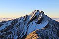
Yushan (玉山)
-
Laonung River at the northeastern side of Yushan
-
Sea of clouds on Yushan Trail
-
Sea of clouds on Yushan Trail
-
Sea of clouds on Yushan Trail
-
Sea of clouds near Tatajia Anbu on Yushan Trail
-

Mountain in the morning
-
Sunrise at Yushan
-
Sunrise at Yushan
-
Sunrise at Yushan
-
Sunrise at Yushan
-
Mountain with sunset
-
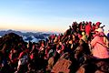
Hikers at the summit
-
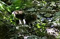
Formosan rock macaque found on Yushan Trail
-
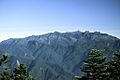
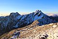
Yushan Range, eastern side view
-
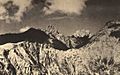
Yushan on November 1, 1935
-
Painting of Yushan by Nasu Masaki (那須雅城)
.jpg)
.jpg)


_in_the_morning.jpg)


_with_sun_set.jpg)


.jpg)

See also
 In Spanish: Yu Shan para niños
- 100 Peaks of Taiwan
- List of mountains in Taiwan
- List of islands by highest point
- Yushan National Park
- Yushan Range
- Yushan-class landing platform dock
- Green Jade
