
2009 Victorian bushfires facts for kids
Quick facts for kids 2009 Victorian bushfires |
|
|---|---|

MODIS Aqua satellite photo of the fires in eastern Victoria, February 7, 2009. By February 8, smoke from the bushfires had reached New Zealand.
|
|
| Location | Victoria, Australia |
| Statistics | |
| Date(s) | 7–14 February 2009 |
| Burned area | over 450,000 ha (1,111,974 acres) |
| Land use | Urban/Rural Areas, Farmland, and Forest Reserves/National Parks |
| Deaths | 173 |
The 2009 Victorian bushfires, also known as Black Saturday, were over 400 bushfires that started in Victoria, Australia on February 7, 2009. These fires caused Australia's worst loss of life ever from a bushfire. Police reported that 173 people died. About 100 people were taken to hospitals with serious burns.
The fires destroyed at least 2,029 homes and 3,500 buildings in total. Many towns north-east of the state capital Melbourne were badly damaged or almost completely wiped out. These included Kinglake, Marysville, Narbethong, Strathewen, and Flowerdale. Many houses in Steels Creek, Humevale, Wandong, St Andrews, Callignee, and Koornalla were also destroyed or damaged. People died in each of these towns. The fires affected 78 towns and left about 7,500 people without homes. More than 4,000 firefighters worked to control the fires, which kept burning for over two weeks.
Most of the fires started and spread on a day with some of the worst bushfire weather ever recorded. The temperature in Victoria reached 46 degrees Celsius, and wind speeds were over 100 km/h. The strong winds blew the fires over large areas, creating huge firestorms. North-east of Melbourne, one firestorm alone killed 120 people. A cool change in the weather arrived in the early evening, but it brought strong south-westerly winds of more than 120 km/h. This sudden change in wind direction turned the long sides of the fires into wide fire fronts. These fronts then burned quickly towards towns that had seemed safe earlier.
Many of the fires were started by fallen or clashing power lines. Some were also started on purpose. Other causes included lightning, cigarette butts, and sparks from power tools. A ten-year drought had made the land and forests very dry, so they burned quickly. Finally, in early to mid-March, the weather changed, which helped firefighters put out the remaining fires.
Understanding the Fires
Extreme Heatwave Conditions
.png)
Starting in late January, south-east Australia experienced several days of very hot weather, known as a heatwave. This heatwave was caused by a slow-moving high-pressure system over the Tasman Sea. A large Tropical Cyclone off Australia's north-west coast and a monsoon trough over northern Australia also played a part. This combination caused hot tropical air to move south over south-eastern Australia.
The February fires began on the hottest day ever recorded in Victoria. Temperature records in the state have been kept since 1859. On February 6, 2009 – the day before the main fires – the Premier of Victoria, John Brumby, warned people about the coming extreme heat. He also said there was a very high danger of bushfires. He told everyone to be extremely careful. Premier Brumby even stated that it would be the "worst day of fire conditions in the history of the state."

Earlier Gippsland Fires
In late January, there were already fires burning in the Gippsland area of Victoria. These included a small fire of 30 ha (74 acres) near Delburn, Victoria. Another fire almost burned a pine tree plantation. There were also two small grass fires near the city of Sale, Victoria, which were started on purpose.
On January 29, over 500 firefighters battled two fires at Delburn that had joined into one large blaze. These fires had burned 1,000 ha (2,471 acres) near Boolarra and Darlimurra, south of Morwell. No buildings were burned at that time. A cool change in the weather on January 30 helped fight the fires, but it also brought strong winds. These winds caused spot fires, which are new small fires started by burning plants blown ahead of the main fire. By the evening of January 31, fire crews worked to stop the fire from spreading north. They also fought to protect the main power transmission lines that carry electricity to Melbourne from the Latrobe Valley. The fire was also close to the Hazelwood Power Station in Victoria.
By February 1, firefighters had created fire breaks (clear areas) around the Boolarra fire. However, it was still burning out of control. This fire had burned through 6,500 ha (16,062 acres) and destroyed 29 houses, farm buildings, and animals. Police believed the Delburn and Boolarra fires were started on purpose. They offered a $100,000 reward for information that could lead to the arrest of those who started the fires.
On February 2, lightning started 23 new fires. These included three in the Bunyip State Park, and fires near Drouin West and Leongatha. However, more humidity helped stop these fires from spreading too much. By February 3, the Country Fire Authority (CFA) grouped the fires into six areas. Five fires were under control, but one near Mirboo North was not.
Main Fire Areas
The biggest fires included:
North and Central Victoria
Kinglake and Marysville Fires

The Kinglake fire was named when two separate fires joined together. This happened after the wind changed direction on February 7 and 8. By February 8, this massive fire had burned over 210,000 ha (518,921 acres). A total of 147 people died in the Kinglake fire area.
The first of these two fires started at Kilmore East, Victoria, on the afternoon of February 7, 2009. It burned 30 km (19 mi) south-east towards St. Andrews, passing through Wandong and Clonbinane. This fire destroyed 30 houses in Wandong and Heathcote Junction on February 7. By February 8, 150 houses had been destroyed in Wandong, and four people were killed. The fire also closed the Seymour railway line and parts of the Hume Highway near Kilmore. The north-west winds pushed the front of the fire towards St Andrews. Then, around 7:30 pm, the weather changed, and the wind shifted to the south-west. This wind change turned the long, narrow fire into a wide fire front that moved north-east towards Kinglake and Strathewen.
By the evening of February 8, 100 people who had escaped the Kilmore fire were sheltering in a basketball stadium at Wallan. Many of them could not go back to their homes because the police had closed the roads.
The fire front burned through the Kinglake area on February 7. This was the worst-hit fire area in the state. In Kinglake, 37 people were killed, and more than 550 houses were destroyed. Another 12 people died at Kinglake West, and in Strathewen, 27 people lost their lives.
The second major fire destroyed the town of Marysville, Victoria. It started north of Marysville. At first, people thought it would go around the town. However, within minutes, the town became an inferno. Around 5:00 pm, the electric power went out, and the wind stopped. Minutes later, the wind returned from a different direction, bringing the fire up the valley. Damage to the water treatment plant in Marysville made the water unsafe to drink. On February 11, it was reported that 100 people out of the town's population of 500 were believed to have died. Only a few buildings were thought to be left. Premier Brumby said: "There's no activity, there's no people, there's no buildings, there's no birds, there's no animals, everything's just gone." These numbers were later updated, but 40 people did die, and almost every building in the town was damaged or destroyed.
About 95% of the houses in Narbethong were destroyed. Other towns affected by the same fire included Taggerty and Buxton. To the south-west, the fire was burning on three sides of Yarra Glen, Victoria, trapping people in the town. Houses north of Yarra Glen were destroyed, and large areas of grasslands were burned.
For some time, the police thought someone had started the fire that burned Marysville, and several people were investigated. However, in June 2011, Victoria Police announced that this was likely not the cause.
Maroondah/Yarra Fires

The Maroondah/Yarra fire was named on February 10. This happened when several fires that had been burning east of Healesville, Victoria, and Toolangi joined together. By late morning, the fire had burned 505 ha (1,248 acres). There were 184 firefighters and 56 fire trucks battling this blaze. Even though the temperature had cooled, strong winds blew embers and started new fires. Around midday, the danger to properties around Healesville was lowered. However, the Department of Sustainability and Environment still advised people to watch for changes in the weather.
The fires in the Maroondah/Yarra area continued to threaten the town of Healesville, Victoria, until February 14.
Beechworth Fire

In Beechworth, Victoria, a fire burned more than 30,000 ha (74,132 acres). It came close to the towns of Yackandandah, Stanley, Bruarong, Dederang, Kancoona, Kancoona South, Coralbank, Glen Creek, and Running Creek, Victoria. The fire started at 7:00 pm on February 7, 3 km (2 mi) south of Beechworth. Hot northerly winds then pushed it south through pine plantations.
The fire destroyed buildings at Mudgegonga, Victoria, south-east of Beechworth; 2 people died there. Thick smoke and clouds made it hard to figure out the exact size of the Beechworth fire.

Strong winds made the fire worse on the night of February 8. Lightning also started a new fire at Kergunyah around midday on February 9. More than 440 firefighters worked to stop a new fire that threatened Gundowring and Eskdale, Victoria, after it jumped the Kiewa River. On the night of February 9, the biggest danger was to Eskdale. Fires were also burning in pine plantations 8 km (5 mi) from the large town of Myrtleford, at the opposite, western end of the fire area. While smaller towns to the east, including Gundowring and Kergunyah, were still threatened, the CFA said there was no immediate danger to the larger towns of Beechworth and Yackandandah, on the northern edge of the fire area.
By February 10, firefighters had completed a 115 km (71 mi) fire break around the Beechworth fire. They were trying to make 15 km (9 mi) more, as the fire was still burning out of control. By the afternoon, the fire threat had been lowered. However, firefighters were battling a new fire near Koetong, Victoria, east of the main Beechworth fire. This new fire was between 50 ha (124 acres) to 80 ha (198 acres) in size. People in Beechworth and nearby towns were told on the evening of February 10 to expect more smoke. This was because 250 firefighters would be doing back-burning to create more firebreaks.
The Beechworth Correctional Centre, a prison, offered up to thirty prisoners to help the firefighters.
Bendigo Fire

A fire west of the city of Bendigo burned 500 ha (1,236 acres). The fire started around 4:30 pm on February 7. It burned through Long Gully and Eaglehawk, Victoria. It came within 2 km (1 mi) of central Bendigo before firefighters brought it under control late on February 8. The fire destroyed about 45 houses in Bendigo's western suburbs. It also damaged an electricity transmission line, causing power failures in parts of the city. One man from Long Gully, who was sick and unable to leave his house, was killed in the fire. His neighbors tried hard but could not rescue him. The fire changed direction late on February 7 when the weather changed, and it turned back towards Eaglehawk. It was controlled around midday on February 8.
A relief center was set up at the Kangaroo Flat, Victoria Senior Citizens Centre. During the fire, people from Long Gully, Eaglehawk, Maiden Gully, California Gully, and West Bendigo were moved from their homes and sent to this center. The police are investigating whether someone had started this fire. The CFA thinks the fire started from a cigarette thrown from a car or truck on the highway.
Redesdale Fire
In Redesdale, a fire burned 10,000 ha (24,711 acres). The fire started 9 km (6 mi) west of the town. It was close to the towns of Baynton and Glenhope. Glenhope was threatened again on February 9 by a smaller fire that broke away from the main blaze. More firefighters and trucks were brought in from Bendigo and Kyneton. By February 10, the fire had been controlled, having destroyed 12 houses and farm buildings.
East Victoria Fires
Bunyip Fire
A fire at Bunyip State Park burned houses at Longwarry North and Drouin West, Victoria. It also affected farms and businesses after the fire jumped the Princes Highway.
The fire was stopped by the afternoon of February 9, after it had burned through 24,500 ha (60,541 acres). The fire destroyed at least eight houses, other buildings, and a factory. Fire crews began back-burning to stop the fire on February 9. People between Pakenham and Warragul, Victoria, were warned about smoke from these fires.
Many farmers, unable to keep animals on their farms because of fire damage, took them to nearby saleyards. By February 9, hundreds of cattle from the Bunyip fire area were taken to the saleyards at Pakenham.
Churchill Fire
The Churchill fire began in a pine plantation 1 km (1 mi) south-east of Churchill, Victoria, on the afternoon of February 7. Within 30 minutes, it had spread to the south-east, near Hazelwood South, Traralgon South, Jeeralang, and Budgeree East, Victoria. By late afternoon, the fire was near Yarram and Woodside, Victoria, on the south Gippsland coast. The weather changed around 6:00 pm, and the south-west winds then pushed the fire north-east towards Gormandale and Willung South on the Hyland Highway. About 500 people sheltered at a theatre in Traralgon.
The fire came close to the Loy Yang Power Station and the station's open-cut coal mine. On the night of February 7, the fire approached the mine's overburden dump. However, it did not cause any damage and did not stop the station's operations. Several small fires broke out in the bunker storing coal from the mine, but they were contained without damage. The threat eased by the evening of February 8, as temperatures cooled and some light rain fell. One small fire started south of the power station, but water-bombing aircraft put it out.
By February 9, the Churchill fire was still burning out of control. Its fronts were moving through the Latrobe Valley and the Strzelecki Ranges. By late afternoon, the fire had burned 32,860 ha (81,199 acres) and killed several people. Wind changes that evening made parts of the fire worse. The CFA warned people at Won Wron and nearby areas to be ready.
Police believe someone started the Churchill fire on purpose. A man from Churchill was arrested by police on February 12. He was charged on February 13 with arson causing death and lighting a bushfire.
Dandenong Ranges Fires

A fire started at Ferntree Gully and Upper Ferntree Gully, in the Dandenong Ranges. All major roads were closed. The fire damaged the railway track at Upper Ferntree Gully, causing the Belgrave railway line to be closed. This fire, which firefighters controlled within three hours, burned 2 ha (5 acres) along the railway.
A house fire started on the morning of February 12 in Upper Ferntree Gully, killing a volunteer firefighter from the CFA. Police think this fire was also started on purpose.
Narre Warren Fires
In Narre Warren, there were several fires. Six homes were destroyed in Narre Warren South, and three in Narre Warren North.
Wilsons Promontory Fire
On February 8, lightning started a fire at Wilsons Promontory. It quickly burned over 2,850 acres (1,153 ha). This fire did not threaten the camping area, but the National Park rangers decided to evacuate the park. Some campers were taken out by boat. The fire continued to burn out of control for more than 10 days. By February 17, it had burned an area of 11,000 ha (27,182 acres), including the air strip and cutting the main road.
West Victoria Fires
Horsham Fire
The Horsham fire burned 5,700 ha (14,085 acres), including the golf club and eight homes. A Dimboola fire truck was also damaged.
The fire started at 12:30 pm on February 7, when strong winds blew over a power pole at Remlaw, west of the city. The fire first went south-west and then south-east, crossing the Wimmera Highway and Wimmera River to the Horsham Golf Course and then to Haven, south of the city. Firefighters were able to save the general store, town hall, and school at Haven, even though flames came within meters of those buildings. Winds of up to 90 km/h (56 mph) changed direction three times during the day. A CFA firefighter described the conditions as the worst he had ever seen. A taxi driver picked up an 82-year-old woman in a wheelchair and her daughter from her house when the fire was no more than 100 yd (91 m) away. The house was on fire as the taxi drove off and burned down within minutes.
At 3:00 pm, more than 400 firefighters were battling the fire. They were supported by two water-bombing aircraft, 54 Country Fire Authority (CFA) fire trucks, and 35 Department of Sustainability and the Environment (DSE) fire crews. By 6:00 pm, the fire had moved east. As the wind changed, it was then pushed north-east across the Western Highway to Drung, east of Horsham.
Coleraine Fire
At Coleraine, 770 ha (1,903 acres) were burned. One man was badly burned.
Impacts of the Fires

Deaths and Injuries
A total of 173 people are known to have been killed by the fires. The death toll was initially thought to be 210, but later forensic tests showed that some human remains believed to be from two or more people were actually from one person.
Some well-known people died in the fires. Brian Naylor, a famous retired television news reader, and his wife Moiree, died in the Kinglake West area. Actor Reg Evans and his partner, artist Angela Brunton, who lived on a small farm in the St. Andrews area, also died in the Kinglake area fire. Ornithologist Richard Zann died in the Kinglake fire, along with his wife Eileen and daughter Eva.
Over 500 people received treatment for burns, and 100 people were sent to hospitals.
A temporary morgue was set up at the Coronial Services Centre in Southbank, Melbourne, to hold up to 300 bodies. This was similar to the one set up after the July 2005 London bombings. Several funeral homes helped transport bodies to Melbourne. By February 10, 101 bodies had been taken to the temporary morgue. There were more than 50 unnamed bodies kept in the morgue or still at the fire areas. The director of the Victorian Institute of Forensic Medicine said it might be impossible to identify all the bodies.
On February 11, Police Commissioner Nixon hoped that searches for bodies would be finished by February 15. The search was slow because there might be asbestos in some of the destroyed buildings.
People from other countries were also killed in these bushfires, including:
- Greece - 2
- New Zealand - 1
- Philippines - 2
- United Kingdom - 1
Images for kids
-
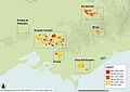
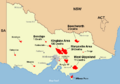
Map of fire locations on 10 February
-
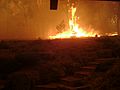
Fire approaching a residence in Steels Creek at 6:11 pm
-
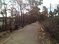
Fire damaged bushland surrounds the Ringwood - Belgrave Rail Trail in Upper Ferntree Gully
-
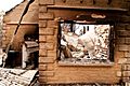
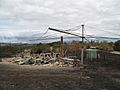
Property destroyed by fire at Kinglake after the Black Saturday bushfires
-
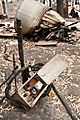
Remains of a destroyed property at Kinglake after the Black Saturday bushfires
-
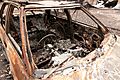
A burnt out car at Kinglake after the Black Saturday bushfires
-
Destroyed property at Kinglake after the Black Saturday bushfires
-
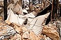
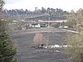
Bushfire damage to property just north of Yarra Glen, with just the Hills Hoist left standing
-
Map of affected areas and number of casualties in each area
-
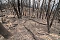
The Kinglake National Park after the Black Saturday bushfires
-
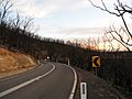
The St. Andrews-Kinglake Road, one of the few roads out of the fire area, two months after the bushfires
-
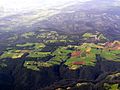
Aerial view of the Kinglake area looking north, nine months after bushfires (burnt area top third of image)
-
Yarra Glen three days after the fires showing differential property survival


See also
 In Spanish: Incendios forestales en Victoria de febrero de 2009 para niños
