
Alviso, San Jose facts for kids
Quick facts for kids
Alviso
|
|
|---|---|
|
Neighborhood of San Jose
|
|
_(cropped).jpg)   _(cropped).jpg)  Clockwise: Aerial view of New Years Eve celebrations in Alviso; new townhomes in El Dorado; homes in Alviso; San Francisco Bay; townhomes on North First.
|
|

Alviso
Location in San Jose, California
|
|
| Country | United States |
| State | California |
| Region | San Francisco Bay Area |
| County | Santa Clara County |
| Incorporated (City of Alviso) |
March 26, 1852 |
| Consolidated with San Jose |
March 12, 1968 |
| Population
(2020)
|
|
| • Total | 2,251 |
| Demonym(s) | Alvisans |
| Time zone | UTC−8 (Pacific) |
| • Summer (DST) | UTC−7 (PDT) |
| ZIP Code |
95002
|
| Area codes | 408/669 |
| GNIS feature ID | 233410 |
|
Alviso Historic District
|
|
| Area | 9 acres (3.6 ha) |
| Built | 1851 |
| NRHP reference No. | 73000449 |
| Added to NRHP | October 9, 1973 |
Alviso is a special neighborhood in San Jose, California. It's located right on the southern edge of the San Francisco Bay. Alviso was once its own town, started in 1852. Today, it's San Jose's only area with a waterfront. It's mostly a place where people live, but it also has some Silicon Valley tech companies and fun businesses.
Alviso got its name from Ignacio Alviso. He was a rancher in the 1800s who owned the land as part of his Rancho Rincón de Los Esteros. The Guadalupe River is to the west, separating Alviso from Santa Clara and Sunnyvale. To the east, Coyote Creek separates it from Milpitas. Alviso is the lowest spot in the San Francisco Bay Area, sitting about 13 feet (4.0 m) below sea level.
Contents
Alviso's Past: A Look Back in Time

Alviso was first settled in the 1700s. It was named after Ignacio Alviso, whose father was part of the early De Anza Expedition. In 1840, Ignacio Alviso moved to a large ranch called Rancho Rincón de los Esteros. From this spot, things like beaver furs and animal hides were shipped to San Francisco.
The city of Alviso officially became a city on March 26, 1852. It was the first city in California to get a special city charter. It became an important port for San José and a transportation center for the Santa Clara Valley. Steamboats regularly traveled between San Francisco and Alviso. However, this changed when railroads became more popular. In 1864, the main railroad line bypassed Alviso. But by the 1880s, Alviso was a stop on another railroad line.
Alviso was home to many successful businesses over the years. Alviso Mills, started in 1853, made a lot of flour. But when wheat farming grew in other areas, the mill closed in 1885. In 1906, the Bayside Canning Company opened. It became the third largest cannery in the United States! During the Great Depression, Alviso was known for its dance halls and gambling spots. In the 1960s and 1970s, a small community of boat builders also grew there.
Alviso stopped being its own city on March 12, 1968. It joined with the City of San Jose after a close vote. The last time it was counted as a separate city in the census was in 1960, with 1,174 people. Even today, the United States Postal Service still recognizes "Alviso" as a place name.
After the 1970s, Alviso faced challenges. It was hit hard by floods in the early 1980s, especially because it's below sea level. Water was very deep in some places, destroying many homes and businesses. On October 9, 1973, 9 acres (3.6 ha) of Alviso were added to the National Register of Historic Places. This area is known as the Alviso Historic District.
Today, shipping and heavy industry have left Alviso. It is mostly a small neighborhood where people live. Some tech companies, like TiVo and Polycom, have their main offices here. Many salt evaporation ponds in the area are being turned back into wetlands. This is part of the Don Edwards San Francisco Bay National Wildlife Refuge.
Alviso has experienced severe flooding many times, including in 1983 and 1995. As of 2021, Amtrak trains and the Altamont Commuter Express still travel through Alviso.
-
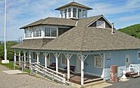
The historic South Bay Yacht Club, founded in 1888
-
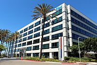
Flex headquarters in Alviso
-
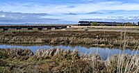
Amtrak train at Guadalupe River, Alviso
-
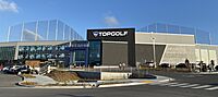
Topgolf San Jose
-
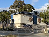
Alviso Branch Library of the San José Public Library
_(cropped).jpg)


.jpg)

Who Lives in Alviso?
Alviso's Population in 2020
In 2020, the census showed that Alviso had 2,251 people living there. There were 558 households, with an average of about 4 people per home.
- About 23.9% of residents were White.
- About 14.0% were Asian (including people of Indian, Vietnamese, Chinese, and Filipino backgrounds).
- About 1.7% were Native American.
- About 53.3% were from other races.
- About 4.8% were from two or more races.
- A large number of residents, 61%, were of Hispanic or Latino background. Most of these, 59.6% of the neighborhood's population, were of Mexican descent.
Fun Things to Do in Alviso
Alviso Marina County Park

This park is 18.9 acres (76,000 m2) and is located right by the bay. It offers many activities both inside the park and in the nearby Wildlife Refuge. The park was improved in 2005 with a boardwalk, trails, and picnic areas. In 2010, new boat launch ramps were added. The paths and boardwalks offer amazing views of the mountains around the bay and the wildlife that lives in the ponds.

You can bring dogs on the park's pathways and picnic areas. However, dogs are not allowed on the trails, levees, and boardwalks. Bicycles are allowed on all pathways and trails, but you should walk them on the boardwalks. The boat ramp is one of the few ways to get from San Jose through the salt marshes to the open waters of the San Francisco Bay.
Day on the Bay Celebration
Every year in October, Alviso hosts "Day on the Bay." This is a free, multicultural event sponsored by Santa Clara County. It's a fun day for families with music, food, community booths, Halloween pumpkins, kayak rides, and other activities.
Day on the Bay started on October 16, 2010. It celebrated the opening of the newly improved Marina Park. About 5,000 people attended this first event. It was created to celebrate the new park and to encourage different groups of people to enjoy the outdoors.
Don Edwards San Francisco Bay National Wildlife Refuge

The Don Edwards San Francisco Bay National Wildlife Refuge was the first urban National Wildlife Refuge in the United States. Its goal is to protect and improve wildlife habitats, especially for migratory birds and endangered species. It also provides chances for people to enjoy nature and learn about wildlife.
As of 2004, the Refuge covers 30,000 acres (12,000 ha) of open bay, salt ponds, salt marshes, mudflats, and other habitats. It's located throughout the southern San Francisco Bay. The Refuge is on the Pacific Flyway, a route many birds use during migration. Over 280 types of birds visit each year. Millions of shorebirds and waterfowl stop here to rest and eat during their spring and fall journeys. The Refuge also provides a home for animals that live there all year, like the endangered Ridgway's rail and salt marsh harvest mouse.
The Don Edwards San Francisco Bay National Wildlife Refuge is part of a larger group of seven wildlife refuges in the San Francisco Bay Area. It was started in 1974. In 1995, it was renamed after Don Edwards, a Congressman who worked hard to protect wetlands in the South San Francisco Bay.
Historic Places in Alviso
Bayside Cannery

The Bayside Cannery is a historic building in Alviso, built in 1906. It has a Mission Revival style. The cannery originally started in San Francisco. It moved to Alviso after the 1906 San Francisco earthquake. The Bayside Cannery grew to be the third largest canning company in the world. It closed in 1936. Today, the San Francisco Bay Bird Observatory uses the property.
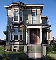
Tilden–Laine House
.JPG)
This is a beautiful Italianate–Victorian home built in 1887 by Susan Tilden. It is located on Elizabeth Street. The Laine family still lives in the home today.
Images for kids
-
Tilden House, built 1887
See also
 In Spanish: Alviso (California) para niños
