Amon Creek facts for kids
Quick facts for kids Amon Creek |
|
|---|---|

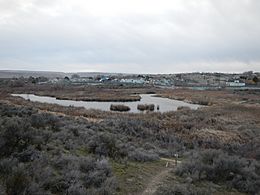
The West Fork of Amon Creek in Richland
|
|
|
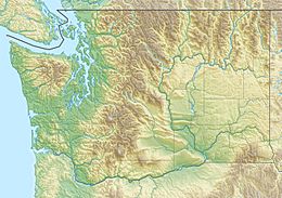
Location of the mouth of Amon Creek in Washington
|
|
| Country | United States |
| State | Washington |
| Cities | Kennewick, Richland |
| Physical characteristics | |
| Main source | Rural Benton County, Washington, United States 1,688 ft (515 m) 46°05′48″N 119°16′02″W / 46.09667°N 119.26722°W |
| River mouth | Yakima River Richland, Benton County, Washington, United States 351 ft (107 m) 46°14′50″N 119°15′41″W / 46.24722°N 119.26139°W |
| Length | 13 mi (21 km) Length measured from the East Fork Source to Mouth at the Yakima River. |
| Basin features | |
| Basin size | 62.24 sq mi (161.2 km2) |
| Tributaries |
|
Amon Creek is the biggest stream that flows into the lower part of the Yakima River in Benton County, Washington. It flows for about 13 miles (21 km) from where its East Fork begins all the way to the Yakima River. Along its path, it goes through the cities of Kennewick and Richland.
Both the East Fork and the main part of the creek (after the two forks meet) flow from south to north. The West Fork starts by heading south in Badger Canyon. It then slowly curves around the canyon's shape to flow north. You can easily see a green, watery area called a riparian zone along most of the creek. This zone also follows the West Fork up Badger Canyon and the East Fork until Interstate 82.
Contents
What is Amon Creek?
The entire path of Amon Creek and its two forks is within Benton County. The creek flows through a semi-arid climate. This means it's a dry area, located in the rain shadow of the Cascade mountains. Because of this dry climate, the creek acts like an important oasis. This is especially true in areas away from towns.
The water in the West Fork mostly comes from springs in and around Badger Canyon. The water in the East Fork mainly comes from extra water from nearby irrigation canals.
The Main Part of the Creek
The East and West Forks of Amon Creek meet at the Meadow Springs Country Club in Richland. From there, the creek flows north through a canyon in Richland's neighborhoods. After passing under Columbia Park Trail, the creek enters a thick forest. This forest is part of the Yakima River Delta. The creek then ends at the Yakima River, about a mile from where the Yakima meets the Columbia. Only about 1% of the water flowing into the Yakima River from Amon Creek is natural.
The West Fork
The West Fork of Amon Creek starts in Badger Canyon, southwest of Richland. It flows through the canyon next to Badger Road. Near Cottonwood Elementary School, it turns away and flows under Interstate 82. From there, it goes through the Amon Creek Natural Preserve. After that, it flows into the Meadow Springs Country Club, where it joins the East Fork.
The East Fork
The East Fork of Amon Creek begins in the Horse Heaven Hills south of Kennewick. It usually only flows when the irrigation canals are full. Above Interstate 82, the East Fork is often dry. It only has water during heavy snowmelt or rainfall. After passing under I-82 and entering Kennewick, the East Fork is mostly used to carry away extra water from canals. These canals are run by the Kennewick Irrigation District (KID). It then flows past orchards, under Clearwater Avenue, and briefly through Amon Basin. Finally, it enters the Meadow Springs Country Club.
Amon Basin
| Amon Basin | |
|---|---|
| Floor elevation | 500 feet (200 m) |
| Length | 1.1 miles (1.8 km) |
| Width | 0.5 miles (0.8 km) |
| Geography | |
| Rivers | Amon Creek |
Amon Basin is a bowl-shaped area located upstream from the Meadow Springs Country Club. Both the West Fork and the East Fork of Amon Creek are found here. Even though the two forks pass within about a third of a mile of each other, they meet about a mile upstream.
Amon Basin is very important for the local environment. This is especially true in the wetlands along the West Fork. Many different kinds of animals can be seen there. Outside of the green, watery areas, you will find sagebrush. You will also see animals typical of the Columbia Basin.
The basin stretches further south along the West Fork than it does along the East Fork.
Fun Things to Do
There are many fun things to do along Amon Creek. South of Thompson Hill, many people use small dirt roads. These roads cross the East Fork and are popular for off-roading. On the West Fork, just north of I-82, you'll find the Amon Creek Nature Preserve. This preserve is in Amon Basin and has trails for hiking and watching wildlife.
The two forks meet at the Meadow Springs Country Club, which is an 18-hole golf course. At the end of the creek, in the Yakima River Delta, there is a thick forest. The USACE manages this area. It has many trails for hiking and mountain biking. Bird watching is also popular along the whole creek. Many birds use the creek's ecosystem when they are in the Columbia Basin.
Animals and Plants
Below Meadow Springs Country Club, several fish species have been seen. In some years, these can include salmon and trout. However, summer water temperatures can get very warm, over 74 °F (23 °C). This can be deadly for fish. The creek also acts as an oasis with lots of vegetation around it.
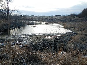
The area around the creek is home to hares, quail, and beavers. River otters have also been spotted in the creek. In Amon Basin, there are about half a dozen beaver dams. These dams create small ponds along the creek in that area. It is thought that fish hatcheries run by the Yakama Nation have helped increase the fish population in the creek.
History of the Creek
About 8 million years ago, the Cascade Mountains began to rise. At that time, the Columbia River changed its path to flow through what is now Wallula Gap. The Yakima River then formed. It flowed through Badger Canyon and the Amon Basin, which were carved out by the Columbia River.
Around 10,000 years ago, huge floods called the Missoula Floods changed the land even more. These floods opened up the Horn Rapids area for the Yakima River to flow through. Today, the West Fork of Amon Creek uses the canyons left behind by the ancient Yakima and Columbia Rivers.
In 1970, the West Fork was changed to provide water for the new Meadow Springs Country Club. They built four reservoirs connected by pipes. This made it almost impossible for fish to swim through the golf course on the West Fork. The East Fork was left in its natural state.
Conditions on the West Fork got worse in 1998. A KID canal broke, releasing sediment with the floodwater. The area upstream of the golf course worked well to hold the flood. However, the top two reservoirs filled with four feet of sediment. This made them only 12 to 18 inches (30 to 46 cm) deep. This greatly raised the water temperatures in the creek.
In 2008, over 16 tons of illegally dumped trash were removed. This trash was found in the new Amon Creek Nature Preserve along the West Fork, just upstream from the golf course. Volunteers also removed 14 broken-down vehicles.
 | Jackie Robinson |
 | Jack Johnson |
 | Althea Gibson |
 | Arthur Ashe |
 | Muhammad Ali |


