Anaheim Hills facts for kids
Quick facts for kids
Anaheim
East Anaheim
|
|
|---|---|
|
District of Anaheim
|
|

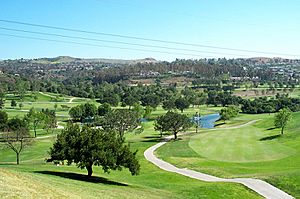
A view of Anaheim Hills from the Anaheim Hills Golf Club
|
|
| Country | United States |
| State | California |
| County | Orange |
| City | Anaheim |
| Elevation | 410 ft (120 m) |
| Time zone | UTC-8 (PST) |
| • Summer (DST) | UTC-7 (PDT) |
| GNIS feature ID | 1951220 |
Anaheim Hills is a special kind of neighborhood in the eastern part of Anaheim, Orange County, California. It's called a planned community because it was carefully designed and built from the ground up.
Contents
History of Anaheim Hills
Before Anaheim Hills was built, there were only a few small neighborhoods in the area. These included Peralta Hills and Mohler Loop, which started in the 1940s and 1950s.
How Anaheim Hills Started
Most of Anaheim Hills was developed in the 1970s. A rancher named Louis Nohl sold his large piece of land in the hills east of Anaheim. In 1970, a company called Texaco Industries bought the land. They planned to build a large, fancy community with 7,000 homes.
The first idea for the community included three new lakes. However, the land's shape and type made this plan impossible.
Building the Community
Construction began in 1971. Anaheim Hills was advertised as a quiet, country-like place. It was different from the crowded neighborhoods in other parts of Orange County. Homes were built on big lots, and there were hiking trails and a golf course.
Anaheim Hills was one of the first places to use "Landform Grading." This is a way of shaping the land to make it look natural and fit the landscape. The community grew quickly. By 1974, the Orange Unified School District built a high school for the growing number of students.
Later Developments
In 1990, the city of Anaheim approved more building near Weir Canyon Road. This expanded Anaheim Hills towards the 241 toll road.
Later, in 2007, another company called Irvine Company got permission to build 2,500 more homes. But in 2014, they decided to donate this land to Orange County. Now, it will stay as open space for everyone to enjoy.
Geography of Anaheim Hills
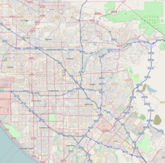
Anaheim Hills is located just south of Yorba Linda, California. It's across the 91 freeway at Imperial Highway.
The western edge of Anaheim Hills is near the 55 freeway. This is across from the city of Orange, California. To the northeast, the community goes past Gypsum Canyon. It borders undeveloped areas of Orange County and the Cleveland National Forest. To the south are the Santa Ana foothills, across from Villa Park, California. All of Anaheim Hills is part of the city of Anaheim, California.
Neighborhoods in Anaheim Hills
Anaheim Hills has many different planned neighborhoods. Here are some of them:
- Amber Lane
- Anaheim Foothills
- Anaheim Ridge Estates
- Bauer Ranch
- Belsomet
- Camino Grande Villas
- Canyon Heights
- Canyon View Estates
- Canyon Hills
- Canyon Pointe
- Canyon Rim/Sunset Ridge
- Canyon Terrace
- Canyon Terrace Estates
- Canyon Terrace Townhomes
- Canyon View Estates
- Canyon View Terrace
- Cape Cod Village
- Carriage Hills
- Crown Pointe
- Carriage Hills
- Copa De Oro
- Embassy Pointe
- East Hills
- Eastridge Estates
- Feather Hill
- Firenze
- Galerie
- Haven Hill
- Hidden Canyon Estates
- Horizons
- Hunters Pointe
- Kings Meadow
- Lake Summit
- Monaco
- Morningview
- Mohler Loop
- Mountain Park
- Nohl Crest
- Old Bridge
- Quail Ridge
- Oak Hills
- Peralta Hills
- Pointe Quissett
- Prado Ridge Estates
- Prado Woods
- Quail Ridge
- Quail Vista
- Renaissance
- Ridgeview
- Rim Crest Villas
- Robin Hill I
- Robin Hill II
- Rocky Point
- Royal Circle Village
- Scout Trail
- Silverbrook Estates
- Singingwood Hills
- Skygate
- Stonegate Hills
- Summer Creek Lane
- Summit Pointe
- Summit Renaissance
- Summit Springs
- Summit Terrace
- Sunset Ridge
- Sycamore Canyon
- The Highlands
- The Summit
- The Palms
- Windsor Terrace
- View Pointe
- Vista Del Sol
- Village at Fiesole
- Villa Palatino
- Window Hill
- Windsor Terrace
- Westridge
- Woodsboro
- Yorba Woods
Education in Anaheim Hills
Students in Anaheim Hills usually attend schools in two different districts. These are the Orange Unified School District or the Placentia-Yorba Linda Unified School District. The second district is for homes north of the Santa Ana River and California State Route 91.
Local Colleges and Universities
For higher education, there are several public community colleges nearby. These include Santiago Canyon College, Orange Coast College, Cypress College, Santa Ana College, Irvine Valley College, and Fullerton College. The closest public four-year universities are California State University, Fullerton and University of California, Irvine.
Elementary Schools
- Anaheim Hills Elementary School
- Canyon Rim Elementary School
- Crescent Elementary School
- Imperial Elementary School
- Nohl Canyon Elementary School
- Running Springs Elementary School
- Woodsboro Elementary School
Middle Schools
- Bernardo Yorba Middle School
- El Rancho Charter School
High Schools
- Canyon High School
- Esperanza High School
Specialty Schools
- Canyon Hills School
- Fairmont Private
- Hillsborough Private
- Hephatha School
Notable People from Anaheim Hills
Many interesting people have lived in Anaheim Hills, including:
- Carlos Cavazo - Guitarist for bands like Quiet Riot and Ratt
- Brandon Baker, actor
- Michael Bisping, MMA fighter
- Ashley Benson, actress
- Rebecca Black, teen pop singer
- Mike Brown, former Head Coach for the Los Angeles Lakers
- Rod Carew, a famous former Major League Baseball player
- Danielle Fishel, actress
- Ashley Force, drag racer
- Ken Forsch, former Major League Baseball pitcher
- Michael Franzese, a former member of a crime family
- Jim Fregosi, former Los Angeles Angels player and manager
- Robby Gordon, NASCAR and off-road racer
- Grant Green, a Minor League Baseball player
- Vladimir Guerrero, a famous former Anaheim Angels player
- Schae Harrison, soap opera actress
- Casey Janssen, Major League Baseball player
- Deacon Jones, a former Los Angeles Rams football player
- Gene Kan, creator of infrasearch.com
- Adam Kennedy, Major League Baseball player
- Kerry King, founder of the band Slayer
- David C. Leestma, NASA astronaut
- Anthony Maglica, owner and founder of Maglite
- Courtney Mathewson, Olympic Gold Medalist in water polo
- Alli Mauzey, actress, known for "Wicked"
- Donnie Moore, a former Major League Baseball pitcher
- Chuck Norris, actor
- Jefferson Thomas, former accountant for the United States Department of Defense
- Eric Valent, former Major League Baseball player
- Cam York, National Hockey League defenceman for the Philadelphia Flyers
Natural Events in Anaheim Hills
Anaheim Hills has experienced natural events like landslides and wildfires. Strong winds called Santa Ana Winds often make wildfires worse in the area.
Landslides
A landslide happened in January 1993. It damaged over 200 homes and destroyed more than 30.
In the winter of 2005, heavy rains in Orange County caused a landslide. A hillside along Ramsgate Drive moved, destroying three homes and a private street.
Wildfires
1982 Gypsum Canyon Fire
The first big wildfire after Anaheim Hills was built happened in October 1982. Strong Santa Ana Winds caused a fire that led to about $50 million in property damage. The fire burned about 17,000 acres (69 km²) and destroyed 14 homes.
2006 Sierra Peak Fire
A wildfire started on February 7, 2006, in the Cleveland National Forest. This forest is between Anaheim Hills and Riverside County. Firefighters had trouble stopping it because of strong winds and warm temperatures. On February 9, the fire got worse, and many parts of Anaheim Hills had to be evacuated. About 75% of the community was asked to leave their homes. Two local elementary schools closed for two days, and other schools became shelters for people who had to leave.
The fire burned over 10,000 acres (40 km²) of land. It also damaged a special type of tree called Tecate cypress. It was later found that a controlled fire set by the Cleveland National Forest started this wildfire.
2007 Windy Ridge Fire
On March 11, 2007, a fire possibly started by a stolen car near the 241 Windy Ridge Toll Plaza. It burned over 2,000 acres (8.1 km²) in Anaheim Hills and the city of Orange. Because of winds up to 35 miles per hour (56 km/h), about 2,500 homes were evacuated. Two people were hurt.
2008 Freeway Complex Fire
The Freeway Complex Fire started in the Corona area on November 15, 2008. It spread into Anaheim Hills, causing 3,100 homes in the Weir Canyon area to be evacuated right away. In total, more than 200 homes were destroyed by this fire. This included 14 houses and 86 apartments in Anaheim Hills.
2017 Canyon Fire 2
On October 8, 2017, the Canyon Fire 2 began near the California State Route 91 and California State Route 241 roads, on the edge of Anaheim. This was the second fire in the same area within a few weeks. The first fire was called the Canyon Fire.
Canyon Fire 2 was made worse by fast winds and dry air. By noon on the day it started, it had burned 800 acres (3.2 km²). By 2:30 PM, it had burned 2,000 acres (8.1 km²) and was not contained at all.
Canyon Fire 2 led to the evacuation of 16,570 people from Anaheim, Orange, North Tustin, Orange Park Acres, and Tustin. It also destroyed 25 homes in Anaheim Hills and Orange.
See also
 In Spanish: Anaheim Hills para niños


