
Anchor Bay (Michigan) facts for kids
Quick facts for kids Anchor Bay |
|
|---|---|

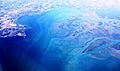
Aerial view of the Anchor Bay from the south towards north, over Macomb County
|
|

Anchor Bay
Location in Michigan

Anchor Bay
Location in the United States
|
|
| Location | (Great Lakes) |
| Coordinates | 42°37′N 82°43′W / 42.617°N 82.717°W |
| Type | Freshwater Bay |
| Primary inflows | St. Clair River, Clinton River, Black Creek and Salt River. |
| Primary outflows | Lake St. Clair and then to the Detroit River |
| Basin countries | United States, Canada |
| Max. length | 9 mi (14 km) |
| Max. width | 10 mi (16 km) |
| Surface area | 90 sq mi (233 km2) |
| Islands | Strawberry Island, and the tips of Dickinson and Harsens Island |
| Settlements | Detroit |
Anchor Bay is a freshwater bay in the U.S. state of Michigan. It is the northern part of Lake St. Clair. Think of it as the top section of the lake.
The bay covers a large area, more than 90 square miles (230 km2). Even though it's big, it's quite shallow. The water depth usually ranges from 1 to 11 feet (0.30 to 3.35 m).
Contents
Exploring Anchor Bay's Location
Anchor Bay is located about 25 miles (40 km) northeast of Detroit, Michigan. It sits just south of New Baltimore, Michigan. The bay also borders several townships like Harrison, Clinton, and Chesterfield.
It's interesting to note that Canadian waters are just south of this U.S. area. These waters make up a big part of Lake St. Clair.
How Big is Anchor Bay?
Anchor Bay stretches over 8 nautical miles (15 km; 9.2 mi) from north to south. It is also more than 9 nautical miles (17 km; 10 mi) wide from east to west. Its total surface area is over 90 square miles (230 km2).
The bay gets its water from the St. Clair River. This river flows south from Lake Huron. It forms a huge river delta where it enters Lake St. Clair. This delta is the largest one in the entire Great Lakes System.
Why is it Called Anchor Bay?
The name "St. Clair" for the lake has a long history. As early as 1710, English maps called it "Saint Clare." By 1755, the spelling became "St. Clair," which is what we use today.
Some people think the name honors American Revolutionary War General Arthur St. Clair. He later became the Governor of the Northwest Territory. However, the name "Lake St. Clair" was used with its current spelling long before he became famous. It's more likely that the lake's name influenced the naming of nearby places. These include St. Clair County and Township in Michigan, and the cities of St. Clair and St. Clair Shores.
The name's origin has also been mixed up with Patrick Sinclair. He was a British officer who bought land on the St. Clair River. In 1764, he built Fort Sinclair there. This fort was used for almost 20 years before it was left empty.
Unlike most smaller lakes, Lake St. Clair has "Lake" at the beginning of its name. This is similar to the Great Lakes. This naming style comes from its French origins.
Water Quality in Anchor Bay
Anchor Bay is part of the largest freshwater delta in the Great Lakes. The water quality here is quite good today. This is true even though there were problems in the past with chemicals building up in fish.
Many cities get their drinking water from the lake or just downstream. Because of this, the water quality is watched very carefully.
Past Pollution Issues
In the early 1970s, the Canadian and American governments stopped commercial fishing. They were worried about mercury building up in the fish. A company called Dow Chemical was responsible for this pollution. They had a plant in Sarnia, Ontario that made chlorine and other chemicals. From 1949, mercury from their production process was released into the river. This contaminated the fish.
The commercial fishery has not reopened since then. However, studies now show that mercury levels are safe.
Boating and Sailing Clubs
Many yacht clubs, which are clubs for boating and sailing, are found along the shores of Anchor Bay. Some of these clubs include:
- Clinton River Boat Club (Club Island), near Harsens Island, Michigan
- Albatross Yacht Club, Anchor Bay, Michigan
- North Star Sail Club, on the Clinton River, Harrison Twp, Michigan
Public Beaches to Enjoy
Anchor Bay offers several public beaches where you can relax and have fun:
- New Baltimore - Beach at Walter and Mary Burke Park in Downtown New Baltimore, Michigan
- Lake St Clair Metropark - Harrison Township, MI
- Many small islands in the bay have sandy beaches or sand bars. These include Strawberry Island and Grassy Bends (known locally as "Grassy"). Be aware that some areas might not be suitable for families.
Fish and Wildlife
Anchor Bay is home to many freshwater fish species found in North America. You can find them throughout the year. Fish popular with people who like to fish include:
- Bass
- Bluegill
- Bullhead
- Catfish
- Muskellunge
- Northern Pike
- Perch
- Salmon
- Smelt
- Steelhead
- Sturgeon
- Trout
- Walleye
Some non-native species have also moved into the lake. These include zebra mussels, sea lampreys, alewives, and round gobies.
Images for kids
-
Aerial view of the Anchor Bay from the south towards north, over Macomb County
