
Arroyo Seco, Querétaro facts for kids
Quick facts for kids
Arroyo Seco, Querétaro
|
|
|---|---|

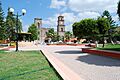
Plaza and main church in municipal seat
|
|

Arroyo Seco, Querétaro
Location in Querétaro

Arroyo Seco, Querétaro
Location in Mexico
|
|
| Country | |
| State | Querétaro |
| Founded | 1833 |
| Municipal Status | 1933 |
| Area | |
| • Total | 731.1665 km2 (282.3050 sq mi) |
| Elevation
(of seat)
|
960 m (3,150 ft) |
| Population
(2005) Municipality
|
|
| • Total | 12,493 |
| • Seat | 1,303 |
| Time zone | UTC-6 (Central (US Central)) |
| • Summer (DST) | UTC-5 (Central) |
| Postal code (of seat) |
76440
|
Arroyo Seco is a town in the far northern part of the Mexican state of Querétaro. It's part of the Sierra Gorda Biosphere Reserve of Querétaro, a special natural area. The town of Arroyo Seco started as a military base and became a town in 1833. It got its current name later. In 1931, it became a municipality.
The area is very rural, meaning most people live in small communities. There are many Pame communities here. The local economy relies on farming, raising animals, and forestry. However, it's also one of the poorest areas in Mexico. Many people move away, especially to the United States, to find work. It's thought that one out of every four families in Arroyo Seco gets money from relatives living in the U.S. The municipality is also home to one of five special Franciscan mission churches built by Junípero Serra. This church is in the community of Concá.
Contents
The Town of Arroyo Seco
Arroyo Seco is a small town with about 300 homes. It has a central plaza named after Mariano Escobedo. The town began as a military outpost called Presidio de Arroyo Seco. It became the main town of the municipality in 1931.
The houses in town are painted in many bright colors, and the streets are usually quiet. Arroyo Seco has all the main services for the municipality. It also has the best buildings and services in the area. These include a cultural center called Casa de Cultura, an auditorium, and a library. The Mariano Escobedo plaza has a unique "oriental" style kiosk surrounded by tall trees. On one side of the plaza is the main church, Nuestra Señora de Guadalupe. This church started being built in 1904. It was planned to be much bigger, but construction stopped because of the Mexican Revolution. Its outside looks simple, and inside it has black pews. The most important event each year in the town is the celebration for the Virgin of Guadalupe on December 12.
You can find local crafts in the town, like saddles, leather items, and wooden barrels used for storing water.
Geography of Arroyo Seco

The municipality is part of the Sierra Gorda region, which is in northern Querétaro state. This region is a part of the Sierra Madre Oriental mountain range. These mountains run parallel to the Gulf of Mexico. Millions of years ago, this land was under the sea. This created old sedimentary rock, mostly limestone, which wears away easily. Arroyo Seco is completely inside the Sierra Gorda Biosphere Reserve of Querétaro, which was created in 1997 to protect its nature.
Mountains and Land
Most of the area is mountainous, with very steep slopes. The land ranges from 560 to 1340 meters above sea level, with an average height of 980 meters. The mountains are divided into two main parts. One part is a long, narrow area along the border with Jalpan. The other part is rougher, with deep canyons and peaks over 2000 meters high. There are also some flat areas and valleys, mostly along the Ayutla and Concá rivers. The main mountains are Santo Domingo, Cantera, Cofradía, Soledad, and Pitorreal.
The ground is made of sedimentary rock, mostly layers of limestone. This rock is found on the surface as medium or fine grains, and sometimes as clay. Like most of the Sierra Gorda, it was once a seabed about 150 million years ago. Recently, Arroyo Seco and other towns in the Sierra Gorda have had many small earthquakes. Scientists say these are caused by water moving through the sedimentary rock. This movement creates gaps, and when these gaps settle, they cause small quakes.
Amazing Caves
Because the area is made of limestone and has a lot of erosion, there are many deep pit caves. The biggest one in the Sierra Gorda is in Arroyo Seco. It's called the Sótano de Barro, located near the Santa María de los Cocos community. The Sótano del Barro is one of the largest caves in the world by its total space inside. It holds 15 million cubic meters of space! It's wider in one direction (420 meters) and averages 200 meters wide. It's 455 meters deep, with a straight drop of 410 meters.
The cave's edge is surrounded by thick plants, which is a safe home for green macaws. To reach it, you need to walk or ride a mule for about two hours through a dense forest. The walls of the pit cave are mostly straight down and partly covered by plants. At the very bottom of the cave, there's a small forest on a floor that was once a seabed millions of years ago. This forest is 220 meters long and 100 meters wide. Even though it's so deep, the bottom of the pit cave gets plenty of sunlight. This allows trees and other plants to grow, making it a unique, isolated mini-forest. The bottom also has several smaller caves.
Rivers and Water
The main rivers in the area are the Santa María, the Ayutla River, and the Jalpan River. They have smaller streams that flow into them, like the Concá River. The Santa María River enters the municipality from San Luis Potosí and flows through a deep canyon. It then joins the Ayutla River. This river flows northeast, forming another canyon, and then joins the Jalpan River. There are about 100 places where you can get water in the municipality. Most of these are in the communities of Salitrillo, Concá, and Ayutla.
The municipality is where two major Sierra Gorda rivers meet: the Santa María and the Ayutla River. This spot is called Las Adjuntas. The Santa María River here can be warm or hot in the summer, while the Ayutla River stays cold. The Santa María River has several beaches where people can camp. You can also fish for native catfish there. The northern border of the municipality is partly formed by the Verde River. The Concá Waterfall is just south of the town of Concá. This waterfall is fed by a fresh spring and flows into the Santa María River.
Even though the name "Arroyo Seco" means "dry stream," most of the streams in the area have water for most of the year. The municipality has ten easy-to-reach sources of surface water. However, too much water is being taken out, which means the underground water levels are dropping. Many of the area's fresh springs are flowing slower or have dried up completely.
Climate and Weather
The municipality has two main climate zones. The north is semi-dry with an average temperature of 22°C. It gets between five and 10.5mm of rain each year, mostly in the summer. The other zone is semi-hot, with average temperatures from 18°C to 22°C, and also gets rain in the summer.
In winter, the area can get cold spells from cold fronts coming from the north and west. These cold spells usually don't reach freezing temperatures because the municipality doesn't have very high mountains like its neighbor, Pinal de Amoles. However, snow mixed with rain fell in 2006. In 2010, some communities like La Florida and San Juan Buenaventura experienced freezing temperatures. Very cold weather can lead to emergency services helping people with blankets or moving them to shelters. Communities most affected by severe cold include La Sanguijuela, La Escondida de Guadalupe, La Cantera, Río del Carrizal, and El Durazno.
The area has also faced problems with droughts over the last ten years, especially in 2009. These droughts have used up water reserves and underground water. The lack of water has caused farm animals to die and forced more people to leave the municipality. Many communities now have to get water delivered by trucks.
Plants and Animals
The plants growing on the limestone and other soils range from lowland rainforests to grasslands and dry scrub brush. In forested areas, you can find oaks, pines, white cedar, strawberry trees, and oyamels. In drier areas, there are also mesquite trees and some desert plants like cactus. In the lowest areas, there are tropical hardwood trees like red cedar, Montezuma cypress, and a tree called "parota."
Wildlife mostly includes birds and mammals. Birds like doves, quails, chachalacas, eagles, roadrunners, and some waterfowl live here. Mammals include squirrels, rabbits, armadillos, white-tailed deer, foxes, coyotes, wild boar, pumas, raccoons, skunks, and opossums. There are also some reptiles like rattlesnakes and coral snakes.
Culture
The most popular traditional music in Arroyo Seco is Huapango, especially Huapango arribeño. This music is often played in "topadas," which are like musical duels. Two musicians compete by making up lyrics and melodies on the spot. Many songs are about history, art, and current events. In 2006, Guadalupe Reyes Reyes from El Refugio won a national award, the Premio Nacional de Ciencias y Artes, for his contributions to Huapango arribeño. Reyes formed a band called Los Reyes de El Refugio. Their music often talks about rural life in the Sierra Gorda. He was born in 1931 and started working on a farm early. He mostly taught himself to read and write. He learned guitar and found he was good at music, becoming a singer at the local church when he was 14.
Typical dishes include jerky, cecina (a type of dried meat), "Serrano" style enchiladas, and barbacoa cooked in a pit. For sweets, there are "chancaquillas," made with piloncillo (unrefined sugar) and squash seeds. Drinks include aguamiel (agave sap) and pulque (fermented agave drink), along with atole (a warm corn drink) with sunflower seeds.
Different communities have festivals to honor their local patron saints. However, the most important festival in the municipality is for the Archangel Michael on September 29. It's celebrated with street fairs and craft shows.
The Mission Church of Concá

The mission complex at Concá is one of five Franciscan missions built under the leadership of Junípero Serra in the mid-1700s. These missions were the last big effort to spread Christianity in the Sierra Gorda. Local people, especially the Chichimeca Jonaz, had resisted these efforts for about 200 years. Their resistance was finally broken in a battle in 1748. To make sure Spanish rule was strong, the Franciscans under Serra built these churches with fancy Baroque fronts in the heart of the Sierra Gorda. Besides Concá, churches were built in Jalpan, Tancoyol, Landa, and Tilaco. The church fronts are special because they have lots of decorations and also include symbols from the local indigenous cultures.
The Concá mission is the smallest of the five. It was built between 1754 and 1758. It is dedicated to the Archangel Michael, and the theme of its front is "The Victory of the Faith." It is thought to have the most indigenous symbols. Many of its decorations show the rougher style of indigenous art. One clear example is an image of the Holy Trinity at the top, which has a rabbit and a two-headed eagle next to it. These are symbols of the Pame people. You can also see the symbol of the Franciscan order, grapevines, two-headed eagles, and images of the Virgin of Guadalupe (Mexico's patroness) and Our Lady of the Pillar (Spain's patroness).
After the missions were handed over to regular priests, many indigenous people left them. This continued during the Mexican War of Independence and the Mexican Revolution, when the churches were damaged and robbed. Work to restore the churches began in 1979 and continued into the 2000s. All five missions were recognized together as a World Heritage Site in 2003.
History
The town was first known as Presidio de Arroyo Seco, a military outpost. In 1833, a missionary named Francisco Cano Santander gave it the church name of Villa de Guadalupe. This was the town's official name until 1840, when it was changed to its current name. The town's coat of arms has three parts. The first part shows the Cross of the Holy Trinity with hands representing both the indigenous people and the missionaries. The second part shows a rabbit, which is also on the front of the Concá mission church. This rabbit is the only one of its kind on any of the five mission churches. The third part shows a stream (arroyo), which is where the name "Arroyo Seco" comes from.

Arroyo Seco is in the middle of the Sierra Gorda region. People have lived here for about 6,000 years. In ancient times, the Sierra Gorda had several small cities because the climate was wetter. As the climate became drier, these cities were left behind. Hunter-gatherer communities became more common, and groups like the Chichimecas, especially the Pames and Chichimeca Jonaz, moved in from the north. Arroyo Seco became Pame territory. Before the Spanish arrived, the Purépecha and Aztecs tried to control the area because of its minerals. But the Chichimecas fought fiercely against them, so neither group truly ruled.
The Spanish tried to enter the Sierra Gorda early in the colonial period. But the Chichimeca, especially the Jonaz, strongly resisted their attempts. This kept the Spanish from fully controlling the area for 200 years.
In 1532, Nuño Beltrán de Guzmán entered the Sierra Gorda and conquered it, but he didn't hold onto it. From that time until the 1700s, many missions were started by the Franciscans and Augustinians. But these missions were either destroyed by the Chichimecas, or the people would run away to more hidden mountains and canyons. The first Spanish settlement in the Arroyo Seco area was in San Nicolás Concá, started between 1533 and 1538. In 1587, Augustinians from Xilitla started missions in Concá and Jalpan. Later, in 1609, the Franciscans were ordered to leave missionary work to the Augustinians. However, some Franciscans stayed and worked with them. The missionaries who lasted the longest were those who learned the Pame language and lived according to Pame customs.
The Spanish finally broke the Chichimeca resistance in the Sierra Gorda in the 1740s. To make their control stronger, Franciscans started new missions in this area. These missions were taken over by Junípero Serra starting in 1750. He decided to build impressive mission complexes in five places, including Concá in this municipality. Besides spreading Christianity, the missions aimed to gather the semi-nomadic Pames into permanent communities around the churches.
There was one battle here during the Mexican Revolution. In 1918, forces attacked the Concá Hacienda. The town of Arroyo Seco was also attacked, and many people were killed. The town was robbed and burned. In response, soldiers loyal to Venustiano Carranza recruited people from Arroyo Seco. They defeated the attackers at Laguna de Concá.
The town officially became a municipality in 1933. The first municipal president was elected in 1935.
In 1994, the municipality built a garbage dump near an important ancient site called San Rafael. This was done without telling the Instituto Nacional de Antropología e Historia (INAH), which protects historical sites. Since 2006, it's been known that the dump is on top of part of the ancient site. It's thought that digging for the dump destroyed between eight and ten ancient pyramids. More parts of the site are located below the dump. The municipality promised to move the dump, and state and federal officials promised a new one. However, the dump was still operating in 2009, taking in a lot of trash each week. Acids from the dump may have damaged the ancient structures made of limestone. This ancient site belongs to the Río Verde Culture and is thought to cover over 10 square kilometers. Its importance has been compared to other major sites like Tamtoc in San Luis Potosí.
In 1998, forests in the municipality were among those destroyed by wildfires. About 180 hectares (445 acres) were burned. These fires happened because of very cold weather in the winter, which dried out the grasslands.
In the late 2000s, the municipality has been dealing with water shortages due to dry conditions. The lack of water has caused farm animals to die and forced more people to leave. Many communities now depend on water brought in by trucks. In 2009, some cattle died from bites by "vampire" bats that carried a type of rabies.
From the late 2000s until now, Arroyo Seco and the rest of the Sierra Gorda in Querétaro have had many small earthquakes. Most of these are too small for people to feel. Scientists say this activity is normal and is caused by the settling of the sedimentary rock underground. However, Arroyo Seco and other municipalities have seismographs installed to watch the situation.
Recently, many working-age people have moved out of the municipality because there aren't enough jobs. Most have gone to the United States. It's estimated that about 40% of the municipality's population lives in the U.S. The money these workers send back home has greatly changed the local economy. It's even more money than what the local economy makes or what the municipality's yearly budget is. In Arroyo Seco, one out of every four homes gets money from family members in the United States. These migrants not only send money directly to their families, but they have also formed groups to help fund projects in their home communities, like paving roads or improving water systems. This migration has caused schools, especially elementary schools, to lose students as families move to the United States.
In 2006, the municipality elected its first municipal president who was not from the PRI since the Mexican Revolution. This president was a former migrant worker.
Construction of a military base began in early 2011 on a 3-hectare (7.4-acre) site. This base is one of three being built to help fight crime along the Querétaro/San Luis Potosí border.
Economy and Tourism
Arroyo Seco is one of the most economically disadvantaged municipalities in the state. This is the main reason why many people from Arroyo Seco and other Sierra Gorda municipalities move away. It's estimated that about 40% of Arroyo Seco's population lives in the United States. The money sent back by these workers is very important. It's estimated that between $50,000 and $100,000 US dollars are sent to the Sierra Gorda every day. This amount is more than the yearly budget of Arroyo Seco and other nearby municipalities. In Arroyo Seco, one in four homes is supported by money sent by family in the United States. These migrants also form clubs to help fund projects in their home communities, like paving roads or improving water systems. Many businesses in the area accept US dollars, especially at the end of the year when many migrants visit their families. Arroyo Seco has one of the highest rates of emigration in Querétaro. The municipality helps organize the "Día del Paisano" (Day of the Countryman) to honor returning migrant workers.
Because so many people leave, only about 23% of the total population works for money. Most of these people work in traditional jobs like farming, raising animals, forestry, and general trade. About 20% of the population works at home without pay. Women make up only 22% of the paid workforce. Most people who are not working for pay are students or homemakers.
Most of the land (about 90%) is used for grazing animals and forestry. The rest is used for farming, mostly during the rainy season. Just over 43% of the working population is in agriculture, livestock, forestry, and fishing. Thirty communities in the municipality do some farming, mostly to feed themselves. The soil is fertile but can be hard and sometimes has drainage problems. One issue is that the soil erodes easily. Fruit trees include mango, oranges, limes, bananas, guavas, avocados, and papaya. Other crops include sugar cane, corn, beans, green chili peppers, tomatoes, watermelon, squash, and sorghum. Most livestock (cattle, sheep, and goats) are raised in communities like El Refugio, San Juan Buenaventura, and Ayutla.
The forests cover 54% of the municipality. Over 80% of the forest has broad-leafed trees. Logging is limited due to conservation efforts for the Sierra Gorda Biosphere Reserve. Fish farming is also growing, especially near rivers.
About 25% of the working population is in mining, construction, and manufacturing. Commerce and services employ about 18%. Most businesses are small grocery stores. Supermarkets are in neighboring San Luis Potosí. Tourism is a small part of the economy, mainly focused on the Concá mission church and some hotels. People also visit to see the 1,000-year-old Montezuma Bald Cypress, called the Árbol Milenario or Millennium Tree. Its trunk is so wide that 22 children holding hands are needed to surround it. A fresh spring flows from its roots.
During the colonial period, there were several large farms (haciendas) in the municipality. One of these was San Nicolás de Concá. It still has lots of plants, a big fresh spring, and hiking trails. The main house has been turned into a hotel, keeping parts of the original adobe structure. The San Nicolas Conca hotel has 50 rooms. This hacienda was originally used for growing sugar cane and dates back to the 1700s.
The El Abanico water park has two swimming pools, a wading pool, a restaurant, gardens, and camping areas. It's located next to the Concá Hacienda. The Hotel Ayutla water park also has swimming pools, wading pools, sports fields, picnic areas, a restaurant, gardens, and camping spots.
Archaeology
The San Rafael site was first recorded in 1939. Archaeologists worked on the site for about ten years. They found that the site was a Mesoamerican city from 200 to 900 CE. It had temples, plazas, patios, and homes built around four ancient ball courts. The city was an important regional government center with strong influences from the Huasteca culture. It had a total of 250 buildings, even more than other well-known sites like Las Ranas and Toluquilla.
It is believed that eight to ten structures at the site have been destroyed, and more may be permanently damaged by acids from the nearby garbage dump. As of 2006, the exact boundaries of the site have not been fully mapped. Parts of the site are located about 300 meters below the dump. The site belongs to the Río Verde Culture and is estimated to cover over 10 square kilometers. Its importance has been compared to that of Tamtoc in San Luis Potosí.
Images for kids
-
Plaza and main church in municipal seat
-
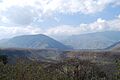
Area between Concá and Arroyo Seco (town)
-
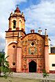
Facade of the mission church at Concá
-
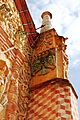
Double headed eagle on the Concá church
See also
 In Spanish: Arroyo Seco (Querétaro) para niños
