Barron County, Wisconsin facts for kids
Quick facts for kids
Barron County
|
|
|---|---|

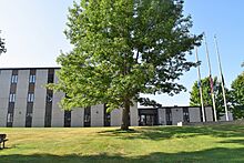
Barron County Government Center
|
|

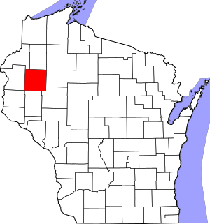
Location within the U.S. state of Wisconsin
|
|
 Wisconsin's location within the U.S. |
|
| Country | |
| State | |
| Founded | 1874 |
| Named for | Henry D. Barron |
| Seat | Barron |
| Largest city | Rice Lake |
| Area | |
| • Total | 890 sq mi (2,300 km2) |
| • Land | 863 sq mi (2,240 km2) |
| • Water | 27 sq mi (70 km2) 3.0% |
| Population
(2020)
|
|
| • Total | 46,711 |
| • Estimate
(2023)
|
46,833 |
| • Density | 54.1/sq mi (20.9/km2) |
| Time zone | UTC−6 (Central) |
| • Summer (DST) | UTC−5 (CDT) |
| Congressional district | 7th |
Barron County is a county located in the state of Wisconsin, USA. It is in the northwestern part of the state. The county's main city, called its county seat, is Barron. In 2020, about 46,711 people lived here. The county was officially created in 1859 and started operating fully in 1874.
Contents
History of Barron County
Barron County was first created in 1859. It was originally named Dallas County. This name honored Vice President George M. Dallas. The city of Barron was chosen as the county seat from the very beginning.
Later, on March 4, 1869, the county's name was changed. It became Barron County. This new name honored Henry D. Barron. He was a lawyer and politician from Wisconsin. He also served as a circuit judge in the area. The county officially started its government in 1874.
In the late 1800s and early 1900s, many families from Russia moved to Barron County. They came here to build new lives.
Geography of Barron County
Barron County covers a total area of about 890 square miles. Most of this area, about 863 square miles, is land. The remaining 27 square miles, which is about 3% of the total, is water. This water includes lakes and rivers.
Neighboring Counties
Barron County shares its borders with several other counties. Knowing these helps you understand its location.
- Washburn County – to the north
- Sawyer County – to the northeast
- Rusk County – to the east
- Chippewa County – to the southeast
- Dunn County – to the south
- St. Croix County – to the southwest
- Polk County – to the west
- Burnett County – to the northwest
Main Roads and Transportation
Many important roads and transportation routes pass through Barron County. These help people travel and goods move around.
Major Highways
Railroads
- Wisconsin Northern Railroad
- Canadian National
Airports
Several airports serve Barron County and the surrounding areas.
- KRPD - Rice Lake Regional Airport
- KUBE - Cumberland Municipal Airport (south of Cumberland)
- Y23 - Chetek Municipal–Southworth Airport
- 9Y7 - Barron Municipal Airport
Population of Barron County
| Historical population | |||
|---|---|---|---|
| Census | Pop. | %± | |
| 1860 | 13 | — | |
| 1870 | 538 | 4,038.5% | |
| 1880 | 7,024 | 1,205.6% | |
| 1890 | 15,416 | 119.5% | |
| 1900 | 23,677 | 53.6% | |
| 1910 | 29,114 | 23.0% | |
| 1920 | 34,281 | 17.7% | |
| 1930 | 34,301 | 0.1% | |
| 1940 | 34,289 | 0.0% | |
| 1950 | 34,703 | 1.2% | |
| 1960 | 34,270 | −1.2% | |
| 1970 | 33,955 | −0.9% | |
| 1980 | 38,730 | 14.1% | |
| 1990 | 40,750 | 5.2% | |
| 2000 | 44,963 | 10.3% | |
| 2010 | 45,870 | 2.0% | |
| 2020 | 46,711 | 1.8% | |
| U.S. Decennial Census 1790–1960 1900–1990 1990–2000 2010 2020 |
|||
2020 Census Information
According to the census taken in 2020, Barron County had a population of 46,711 people. This means there were about 54 people living in each square mile. There were also 23,779 housing units in the county.
Most of the people in the county, about 91.1%, identified as White. Other groups included 1.8% Black or African American, 1.0% Native American, and 0.7% Asian. About 4.2% of the population identified as being from two or more races. About 2.7% of the population was Hispanic or Latino.
Cities, Towns, and Villages
Barron County has several different types of communities. These include cities, villages, and towns.
Cities
- Barron (the county seat)
- Chetek
- Cumberland
- Rice Lake
Villages
- Almena
- Cameron
- Dallas
- Haugen
- New Auburn (mostly in Chippewa County)
- Prairie Farm
- Turtle Lake (partly in Polk County)
Towns
- Almena
- Arland
- Barron
- Bear Lake
- Cedar Lake
- Chetek
- Clinton
- Crystal Lake
- Cumberland
- Dallas
- Dovre
- Doyle
- Lakeland
- Maple Grove
- Maple Plain
- Oak Grove
- Prairie Farm
- Prairie Lake
- Rice Lake
- Sioux Creek
- Stanfold
- Stanley
- Sumner
- Turtle Lake
- Vance Creek
Census-Designated Place
Unincorporated Communities
These are smaller communities that are not officially part of a city or village.
See also
 In Spanish: Condado de Barron para niños
 | Selma Burke |
 | Pauline Powell Burns |
 | Frederick J. Brown |
 | Robert Blackburn |


