Barton County, Missouri facts for kids
Quick facts for kids
Barton County
|
|
|---|---|

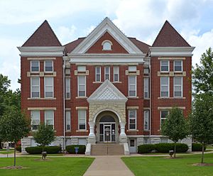
Barton County Courthouse in Lamar
|
|

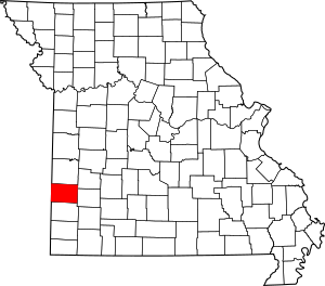
Location within the U.S. state of Missouri
|
|
 Missouri's location within the U.S. |
|
| Country | |
| State | |
| Founded | December 12, 1855 |
| Named for | David Barton |
| Seat | Lamar |
| Largest city | Lamar |
| Area | |
| • Total | 597 sq mi (1,550 km2) |
| • Land | 592 sq mi (1,530 km2) |
| • Water | 4.8 sq mi (12 km2) 0.8% |
| Population
(2020)
|
|
| • Total | 11,637 |
| • Density | 19.492/sq mi (7.526/km2) |
| Time zone | UTC−6 (Central) |
| • Summer (DST) | UTC−5 (CDT) |
| Congressional district | 4th |
Barton County is a county located in the southwestern part of Missouri, a state in the United States. A county is like a smaller region within a state, often with its own local government. In 2020, about 11,637 people lived here. The main town and county seat is Lamar.
Barton County was created in 1855. It was named after David Barton, who was a U.S. Senator from Missouri.
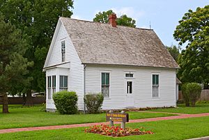
Did you know that President Harry S. Truman was born in Barton County in 1884? Also, a famous historical figure known for her adventures, Little Britches, was born here in 1879.
Contents
Exploring Barton County's Geography
Barton County covers a total area of 597 square miles. Most of this area, 592 square miles, is land. The remaining 4.8 square miles is water, like rivers or lakes.
Neighboring Counties
Barton County shares its borders with several other counties. These are:
- Vernon County to the north
- Cedar County to the northeast
- Dade County to the east
- Jasper County to the south
- Crawford County, Kansas to the west
Main Roads and Highways
Several important roads run through Barton County, helping people travel around. These include:
 Interstate 49
 U.S. Route 71
 U.S. Route 160
 Route 43
 Route 126
Local Airport
The Lamar Municipal Airport (LLU) helps connect the county to other places. It serves the local community and nearby towns.
People and Population in Barton County
| Historical population | |||
|---|---|---|---|
| Census | Pop. | %± | |
| 1860 | 1,817 | — | |
| 1870 | 4,285 | 135.8% | |
| 1880 | 10,332 | 141.1% | |
| 1890 | 18,504 | 79.1% | |
| 1900 | 18,253 | −1.4% | |
| 1910 | 16,747 | −8.3% | |
| 1920 | 16,879 | 0.8% | |
| 1930 | 14,560 | −13.7% | |
| 1940 | 14,148 | −2.8% | |
| 1950 | 12,678 | −10.4% | |
| 1960 | 11,113 | −12.3% | |
| 1970 | 10,431 | −6.1% | |
| 1980 | 11,292 | 8.3% | |
| 1990 | 11,312 | 0.2% | |
| 2000 | 12,541 | 10.9% | |
| 2010 | 12,402 | −1.1% | |
| 2020 | 11,637 | −6.2% | |
| U.S. Decennial Census 1790-1960 1900-1990 1990-2000 2010-2015 |
|||
The census helps us understand who lives in Barton County. In 2000, there were 12,541 people living here. Most people were White (96.93%). There were also smaller groups of Black or African American, Native American, Asian, and Pacific Islander residents. Some people identified with two or more races, and some were Hispanic or Latino.
The average age of people in the county in 2000 was 37 years old. About 27.50% of the population was under 18 years old.
Religious Groups in Barton County
Many people in Barton County follow a religion. The most common religions are different types of Protestant Christianity. The largest groups include Southern Baptists, United Methodists, and Christian Churches and Churches of Christ.
2020 Census Overview
Here's a quick look at the different groups of people living in Barton County, based on the 2020 Census:
| Race | Number of People | Percentage |
|---|---|---|
| White (not Hispanic) | 10,367 | 89% |
| Black or African American (not Hispanic) | 27 | 0.23% |
| Native American (not Hispanic) | 145 | 1.24% |
| Asian (not Hispanic) | 37 | 0.32% |
| Pacific Islander (not Hispanic) | 2 | 0.02% |
| Other/Mixed (not Hispanic) | 793 | 6.81% |
| Hispanic or Latino | 266 | 2.3% |
Learning and Education
Barton County has several schools and libraries that help students learn and grow.
Public Schools
Students in Barton County attend schools in different districts:
- Liberal R-II School District:
- Liberal Elementary School (grades PK-05)
- Liberal Middle School (grades 06-08)
- Liberal High School (grades 09-12)
- Lamar R-I School District:
- Lamar East Primary School (grades K-02)
- Lamar Elementary School (grades 03-05)
- Lamar Middle School (grades 06-08)
- Lamar High School (grades 09-12)
- Golden City R-III School District:
- Golden City Elementary School (grades PK-06)
- Golden City High School (grades 07-12)
Public Libraries
For reading and research, residents can visit:
- Barton County Library
- Sheldon City Library
Towns and Villages in Barton County
Barton County is home to several communities, from larger cities to smaller villages.
Cities
- Golden City
- Lamar (This is the county seat, meaning it's the main administrative town.)
- Liberal
- Mindenmines
Villages
Census-Designated Place
Other Small Communities
These are smaller, unincorporated places in the county:
- Boston
- Bushnell
- Doylesport
- Dublin
- Esrom
- Hannon
- Iantha
- Kenoma
- Nashville
- Newport
- Oakton
- Oskaloosa
- Verdella
County Townships
Barton County is also divided into fifteen smaller areas called townships:
|
|
|
Famous People from Barton County
Many interesting people have connections to Barton County:
- Blaine Durbin — A professional baseball player who played for teams like the Chicago Cubs.
- Wyatt Earp and his family — A well-known lawman from the American frontier.
- Bob Harmon — Another professional baseball player who played for the St. Louis Cardinals.
- Charles Henry Morgan — A U.S. Representative who served Missouri in Congress.
- Harry S. Truman — The 33rd President of the United States (1945–1953). He also served as Vice President and a U.S. Senator for Missouri.
See also
 In Spanish: Condado de Barton (Misuri) para niños
 | Charles R. Drew |
 | Benjamin Banneker |
 | Jane C. Wright |
 | Roger Arliner Young |


