
The Fens facts for kids


The Fens, also known as Fenland, is a naturally marshy area in eastern England. For many centuries, most of this land was wet and marshy. However, a long time ago, people started to drain the water away.
Today, the Fens are mostly a flat, damp, and low-lying region. It is mainly used for agriculture, which means growing crops.
A fen is a single area of marshland, or land that used to be marsh. This land has (or had) water that is neutral or alkaline. This means the water has many dissolved minerals, but not a lot of other things plants need to grow.
The Fenland area is mostly found around the coast of the Wash. It covers parts of four different counties: Lincolnshire, Cambridgeshire, Norfolk, and a small part of Suffolk. The entire area is about 1,500 sq mi (3,900 km2).
Contents
What Makes the Fens Special?
Most of the Fenland is only a few metres above sea level. Some parts are even below sea level! Just like similar areas in the Netherlands, much of the Fenland used to be wetlands. These wetlands had either fresh or salty water.
Over time, people have drained these areas using special systems. They also built banks and use pumps to protect the land from floods. Thanks to this drainage, the Fenland has become a very important arable farming area in Britain. Farmers here grow lots of grains and vegetables. The soil in the Fens is very rich and fertile. About half of England's best farming land is found right here!
Towns and Cities in the Fens
The Fens are home to several important towns and cities. You can find beautiful churches and cathedrals in places like Ely, Ramsey, Crowland, Thorney, and Peterborough.
Other big towns and cities in the Fens include Cambridge, Boston, Spalding, Wisbech, and King's Lynn.
The Lowest Point in the UK
The Fens are much lower than the chalk and limestone hills around them. Most places are no more than 10 metres above sea level. Because of all the drainage and the shrinking of the peat soil, many parts of the Fens are now actually below the average sea level.
In the 1600s, someone wrote that the Fenland was all above sea level. But today, it holds the lowest land point in the United Kingdom! This spot is called Holme Fen in Cambridgeshire. It is about 2.75 metres below sea level.
Fen Islands
Within the Fens, there are a few small hills. Historically, these hills were called "islands" because they stayed dry when the low-lying areas around them were flooded. The biggest of these "fen-islands" is the Isle of Ely. The famous cathedral city of Ely was built on this island. Its highest point is 39 metres above the average sea level.
How the Fens Were Used Before Drainage
Without the artificial drainage and flood protection, the Fens would often flood, especially in winter. This happened because a lot of water flowed down from the higher lands and overflowed the rivers. Some areas of the Fens were always flooded, forming small lakes called meres. Other areas only flooded when there was a lot of water.
Before modern times, arable farming (growing crops) was only possible on the higher surrounding lands, the fen islands, and an area called the "Townlands." The Townlands were a curved strip of silt soil around the Wash. Even though these lands were lower than the peat fens before the peat started to shrink, medieval farmers reclaimed them. They built banks to protect them from floods coming from the peat areas or the sea.
The rest of the Fenland was used for other things:
- Pastoral farming (raising animals)
- Fishing
- fowling (hunting birds)
- Harvesting reeds or sedge for things like thatch (roofing material).
This was different from the rest of southern England at the time, which mostly focused on growing crops.
Modern Farming in the Fens
Since the 1800s and 1900s, modern drainage systems have completely changed the Fens. Today, growing crops has almost entirely replaced raising animals. The economy of the Fens now relies heavily on producing crops. These include grains, vegetables, and other important crops like rapeseed or canola.
Images for kids
-
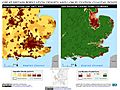
England population density and low elevation coastal zones. The Fens are particularly vulnerable to sea level rise.
-
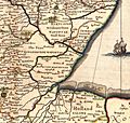
Southern Lincolnshire from a mid-17th-century atlas by Jan Janssonius, showing unsettled areas within undrained fens
-
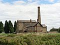
Stretham Old Engine, alongside the River Great Ouse
-
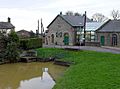
Prickwillow Museum shows the changing face of the Fens and the story of their drainage. It is housed in an old pumping station.
.jpg)
.jpg)


See also
 In Spanish: Fens para niños
