
Big Timber Creek facts for kids
Quick facts for kids Big Timber Creek |
|
|---|---|

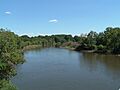
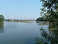
Main stem, looking upstream (2007)
|
|
 |
|
| Country | United States |
| State | New Jersey |
| Physical characteristics | |
| Main source | Big Lebanon Branch Cross Keys, New Jersey 158 ft (48 m) 39°43′38″N 75°01′28″W / 39.72722°N 75.02444°W |
| River mouth | Westville, New Jersey 0 ft (0 m) 39°53′05″N 75°07′59″W / 39.88472°N 75.13306°W |
| Length | 5.6 mi (9.0 km) |
| Basin features | |
| Basin size | 63 sq mi (160 km2) |
Big Timber Creek is a stream in southwestern New Jersey, United States. It is about 5.6 miles (9 km) long. This creek drains a large area of about 63 square miles (163 km²). It flows into the Delaware River between the towns of Brooklawn and Westville. This spot is just south of Gloucester City. The main part of Big Timber Creek and its South Branch form about half of the border between Camden and Gloucester counties.
Long ago, Big Timber Creek was home to many villages of the Lenape people. In colonial times, the creek was a busy waterway for trade. It also powered many mills until the 1950s. Later, in the second half of the 1900s, the creek faced problems from fast development. But by 2007, it had started to get better. This was thanks to new pollution controls and better ways to treat sewage.
Contents
What's in a Name?
The local Lenape tribe called this creek Tetamekanchz. Different parts had other names too. For example, the North Branch was also Tetamekanchz. The Chews Landing area was Arwames. Beaver Branch was Tekoke, and Little Timber Creek was Sassackon.
The name "Timber Creek" first appeared in writings by a Dutch explorer. His name was David P. DeVries. He wrote about a Timmer Kill (which means "Timber Creek" in Dutch). This was after Fort Nassau was built at the creek's mouth in the 1630s. When the Quakers arrived, they made the name sound more English.
In 1697, the people who owned West Jersey decided on a new name. They wanted it to be called the "Gloucester River." This name was used in some papers for a few years. But it eventually disappeared. There's also a smaller creek nearby called Little Timber Creek. It flows into the Delaware River at the same spot. To tell them apart, the larger one became known as "Great Timber Creek." Soon, this changed to "Big Timber Creek." Even today, many people just call it "Timber Creek."
Exploring Big Timber Creek
Where Does the Creek Flow?
Big Timber Creek generally flows towards the northwest. Two main streams, the North Branch and the South Branch, join together. They meet about 5.6 miles (9 km) before the creek reaches the Delaware River. The South Branch is thought to be the very start of the creek. Both branches have dams that create lakes. These lakes are not natural.
The South Branch

The South Branch of Big Timber Creek begins when two smaller streams meet. These are the Big Lebanon Branch and the Little Lebanon Branch.
The Big Lebanon Branch is considered the main source. It starts near Cross Keys in Gloucester County. It flows northwest for about 2.4 miles (3.9 km). Along the way, it gets water from other streams. It passes under the Atlantic City Expressway. It also flows through Jones Lake and Nash's Lake.
The Little Lebanon Branch is also in Gloucester County. It starts near Baum Pond and flows north for about 1.9 miles (3.1 km). It then joins the Big Lebanon Branch.
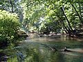
The South Branch itself starts just above Nash's Lake in Washington Township. It flows north for about 9.1 miles (14.6 km). It forms several lakes, like Grenloch Lake and Blackwood Lake. It also receives water from smaller streams. As it gets closer to the main creek, the water becomes slower and affected by tides.
The North Branch

The North Branch of Big Timber Creek starts near Albion. This is about 2.5 miles (4 km) from Pine Hill, which is the highest point in southern New Jersey. The North Branch flows northwest for about 10.1 miles (16.3 km). It passes through several lakes before joining the South Branch.
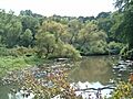
From its start, the North Branch flows near the famous Pine Valley Golf Club. It then enters Lekau Lake. After that, it flows into Clementon Lake in Clementon. This lake has been a popular place for fun for a long time. The North Branch then continues through Laurel Lake. It eventually becomes wider and slower. It finally reaches an area near Chews Landing. Here, the North Branch is affected by tides. It then flows west to meet the South Branch.
The Main Stream

The main part of Big Timber Creek begins in Glendora. This is where the North and South branches meet. It winds northwest for 5.6 miles (9 km) until it empties into the Delaware River. This happens between Westville and Brooklawn. For much of its path, it is surrounded by roads and old dumps. But in some places, it opens up into wetlands. The main stream is always affected by the tides.
The first part of the main stream is like a ditch. It flows between houses and a trash dump. It receives water from Hirsch Lake. Then, Almonesson Creek and Beaver Brook join it. The stream narrows as it goes under Route 42 and the New Jersey Turnpike. It stays narrow for a while, passing under Route 295. After this, it opens into wetlands with channels you can boat through. One channel flows through Bellmawr, with small marinas. The creek then flows under State Route 47. It goes through Michael K. Galbraith Park in Westville. Finally, it opens into a shallow bay and flows into the Delaware River.
The Land Around the Creek
How the Land Was Formed (Geology)
Big Timber Creek is located entirely within the Atlantic Coastal Plain. This area is mostly made of loose layers of sediment (like sand, clay, and gravel). These layers sit on top of very old Precambrian rock. This coastal plain stretches from the Fall Line out to the continental shelf.
New Jersey's inner coastal plain has a very complex geology. Many different layers of sediment have been laid down here over millions of years. These layers were formed by streams and other natural processes. Sometimes, older layers can be found closer to the surface than newer ones. This happens because of cycles of deposition (when new material settles) and erosion (when material is worn away). The surface of the area is mostly weathered sand. You can also find patches of gravel or clay. There isn't much hard rock here. But some sand with iron in it has become very hard and rock-like.
The Shape of the Land (Geography)
Big Timber Creek has cut its way through the soft materials of the inner coastal plain. It has been doing this since the last Pleistocene floods. These floods left fresh layers of sediment. The creek's watershed covers 63 square miles (163 km²). This includes Little Timber Creek, which flows into the Delaware River at the same spot.
The land in this area is not very high. Most of it is below 50 feet (15 m). The highest points are around 200 feet (61 m). Any hills or bumps you see are because of erosion. This means the creek and its tributaries (smaller streams that flow into it) have worn away the land over time.
The land mostly has low, flat ridges. These are common in sandy areas. Some hills are steeper and higher than 100 feet (30 m). These hills have caps of sand rich in iron, which makes them harder. There is also a small, marshy floodplain near the lower parts of the creek.
Images for kids
-
Main stem, looking upstream (2007)
-
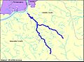
Course of Big Timber Creek
-
South Branch, just below Blackwood Lake, looking downstream
-
North Branch in Stratford, looking downstream
-
Main stream in Bellmawr, looking downstream
