Carrickgollogan facts for kids
Quick facts for kids Carrickgollogan |
|
|---|---|
| Carraig Uallacháin | |
Carrickgollogan
|
|
| Highest point | |
| Elevation | 276 m (906 ft) |
| Geography | |
| Location | Dún Laoghaire–Rathdown, Ireland |
| Parent range | Dublin Mountains |
| OSI/OSNI grid | O23142005 |
| Topo map | OSI Discovery No. 50 |
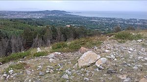
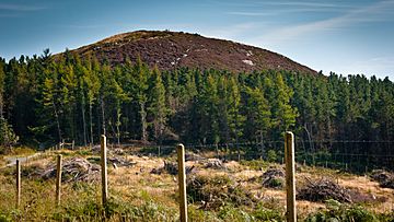
Carrickgollogan (which means "rock of Uallachán" in Irish) is a cool hill in Dún Laoghaire–Rathdown, Ireland. It's located near the southern edge of old County Dublin. This hill is about 276 meters (or 906 feet) tall. It sits on the eastern side of the Dublin Mountains, looking over areas like Rathmichael and Shankill. From the top, you can see amazing views of south Dublin and north County Wicklow.
Contents
What is Carrickgollogan Made Of?
Rocks and Trees
The very top of Carrickgollogan is mostly made of a hard rock called quartzite. The higher parts of the hill have a mix of heathland (open land with small shrubs) and forests where trees are grown for wood. The lower parts are mostly farmland.
The forest on the mountain has many different kinds of trees. These include Lodgepole pine, Noble fir, Japanese larch, Lawson cypress, Scots pine, birch, and beech trees. This makes it a great home for animals like badgers, rabbits, and many types of birds.
Streams and Waterways
Some small streams that form the Wood Brook or Crinken Stream start on the south-western side of Carrickgollogan. These streams join up with others from near Shankill Castle. They then flow under the M11 motorway and out to the sea, just north of Bray.
Amazing Views from the Top
Imagine standing on top of Carrickgollogan and looking out! An author named Weston St. John Joyce wrote about these views in 1912. He said you could see a "fine view" of places like Bray, Howth, Dalkey, and Killiney. You can also see the beautiful valley of Shanganagh, and Bray Head and its town.
Closer to the sea, you'll spot Loughlinstown. It looks very crowded from the hill, like old towns that were built close together for protection. Looking west, you'll see the wooded hill of Barnaslingan. Beyond that are the Two and Three Rock Mountains. Further south, you can see the taller Wicklow hills, including War Hill, Djouce, and Duff Hill. It's a truly stunning sight!
A Look Back in Time: History of Carrickgollogan
Ballycorus Leadmines: A Mining Story
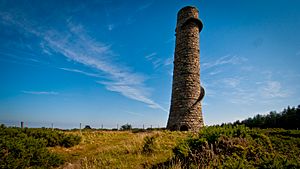
One of the most interesting old landmarks near Carrickgollogan is the ruined chimney of the former lead works at Ballycorus. Mining for lead started here around 1807. Later, in 1826, the Mining Company of Ireland (MCI) took over. They dug for lead and silver underground until 1863.
Most of the work at Ballycorus happened at the smelting factory built by MCI. This factory processed lead from Ballycorus and other mines across Ireland. Even after the local mine ran out of lead in the 1860s, the factory kept working. It processed lead from MCI's mines in Glendalough, County Wicklow. By the 1880s, it wasn't profitable to process Irish lead anymore. So, the factory started processing lead from a mine in the Isle of Man until it finally closed in 1913.
In the 1770s, people discovered a way to get lead from the fumes that came out of the smelting furnaces. To do this, a long chimney pipe, called a flue, was built in 1836. This flue was about 2 kilometers (1.25 miles) long. It ran from the lead works all the way up to a tall chimney near the top of Carrickgollogan.
This special granite chimney has an outside spiral staircase and a viewing platform. It quickly became a famous landmark. Sailors even used it as a guide on their maps! The chimney used to be even taller, with an extra brick section on top that is now gone. This is the only example of such a flue and chimney ever built in Ireland.
Workers would scrape out the lead deposits that collected inside the flue. Sadly, many of these workers got lead poisoning because of this dangerous job. This led to the area around the chimney being nicknamed "Death Valley."
Today, you can still see some of the old buildings from the smelting works in the valley below. These buildings are made of granite and include parts of furnaces, purification tanks, and workers' cottages. Some of these buildings are now private homes. A shot tower, built in 1857, where lead shot (small balls of lead) was made, also still stands.
Rathmichael Old Church and Round Tower
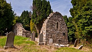
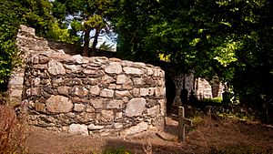
Further down the slopes to the north of Carrickgollogan, you'll find Rathmichael. Here are the ruins of an old church and a round tower. These are inside what was once one of the biggest ringforts (a circular fortified settlement) in Ireland.
The church dates back to Norman times. But the round tower and ringfort show that this site is much older, going back to early Christian times. People believe the monastery and church were founded around the mid-seventh century. The site is also close to an old pilgrimage route that went from St. Mary's Church, Dublin to Glendalough.
The entrance to the ringfort was about 2.4 meters (8 feet) wide and had an arched gateway. The ring wall and mound are about 107 meters (350 feet) across. Its large size suggests that this was once the home of an important chieftain. Inside the ringfort, there would have been a small church and several huts for monks.
Only the base of the round tower remains today, standing about 2 meters (6.5 feet) high. It has a circumference of about 15.5 meters (51 feet). Locals call the tower "The Skull Hole." This is because skulls and bones from the nearby graveyard were put there when the graveyard was cleared to make more space. There's also a local story about an underground passage from the tower to the sea. The story says a piper went into the passage playing his instrument and was never seen again! Parts of a passage, possibly a souterrain (an underground tunnel), have been found near the tower.
Of the church, only the east wall of a thirteenth-century chancel (the part of the church where the altar is) and the south wall of a twelfth-century nave (the main part of the church) are left. The church has been in ruins since the late 1600s.
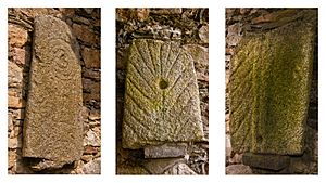
It's famous for its collection of special grave slabs, called leacs in Irish, or the Rathdown stones. Nine of these stones are attached to the south wall of the old church in Rathmichael. There are 32 of these unique slabs found only in the Rathdown area of Ireland. No two stones are exactly alike, but they all have similar designs like circles, cup marks, and zigzag patterns. At first, people thought these stones were from before Christian times. But later research showed they were influenced by Norsemen (Viking) art. Now, it's believed they were grave markers for Norsemen Christians.
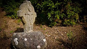
Along Rathmichael Lane, which once led to the old Rathmichael Church, you'll find a twelfth-century cross. It has a Crucifixion scene carved deeply into a granite boulder base. This is one of several crosses, known as the Fassaroe Crosses, found in the area. They are all thought to have been made by the same stonemason. The base is in its original spot, but the cross itself was found in the ruins of a nearby church and put back on its base in 1910. This cross is special because it has a Crucifixion scene on both sides.
People have different ideas about why the cross was there. Maybe it marked a path between the churches at Rathmichael and Kiltuck. Or perhaps it marked the spot of another church that is now gone. There's a story about this cross and a collector named General George Cockburn. He wanted the cross for his collection and sent two men to get it. But when they tried to move it, a big storm blew up. Their horse ran away, and they had to pull the cart themselves. Then, one of the men had a serious accident while unloading the cross, and more bad luck followed his family.
Puck's Castle: A Fortified Home
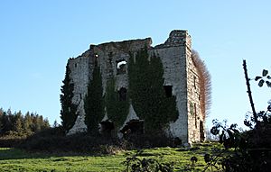
Also to the north of Carrickgollogan are the ruins of a fortified house called "Puck's Castle." The name might come from a story about a fairy (or púca) piper who hopped from rock to rock playing music. Or it could refer to the wild goats that live in the hills.
A historian named Francis Erlington Ball suggested that the building was built around 1537 by Peter Talbot. It was meant to defend the land from attacks by the O'Toole clan. It's a small rectangular building, about 6.7 meters (22 feet) long and 4.5 meters (15 feet) wide inside. It has two stories and very thick walls, about 1.3 meters (4 feet) thick!
King James II visited the castle in 1690 after the Battle of the Boyne. His army was camped nearby. He left a gift of silver for his host, Peter Lawless. Some changes were made to the building in the 1700s, including adding a fireplace and chimney. An old drawing from around 1819 shows two small thatched cottages built onto one side of the castle.
Alcock Memorial: A Tribute
To the south of the summit, there's a special plaque set into the rock. It's a memorial to a Doctor Nathaniel Alcock, put there by his daughters in 1914. The words on the plaque say, "To the Memory of One who Worshipped Here. Doctor Nathaniel Alcock Died 4 April 1904 in His 65th Year. 'A Wise Man is Never so busy as in the Solitary Contemplation of God And the Worship of Nature' Seneca. Erected by his Two Friends". It's a lovely tribute to someone who loved this place.
Ancient Monuments: Clues from the Past
When the Ordnance Survey explored the area in the 1800s, they found signs of several very old monuments on or near Carrickgollogan. Not much is left of them today.
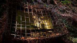
In a field south of the summit, there are three stones arranged like a trilithon (two upright stones with a third across the top). It's not clear if this is what's left of a wedge tomb or a portal tomb (types of ancient burial sites). On the east side of the mountain, a wedge tomb with a 2.35-meter (7.7-foot) long passage was found when a gas pipeline was being laid. It has since been reburied to protect it.
Exploring Carrickgollogan Today
Carrickgollogan is part of a forest recreation area owned by Coillte (Ireland's state forestry company). It's managed by the Dublin Mountains Partnership. There are about 8 kilometers (5 miles) of trails here, including a special path called the Lead Mines Way. You can also try a permanent orienteering course, which is like a treasure hunt using a map and compass. Carrickgollogan is also part of the longer Dublin Mountains Way walking trail. It's a great place to explore and enjoy nature!
 | Leon Lynch |
 | Milton P. Webster |
 | Ferdinand Smith |


