Carson County, Texas facts for kids
Quick facts for kids
Carson County
|
|
|---|---|

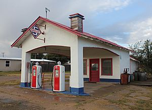
Restored filling station in Skellytown, Texas
|
|

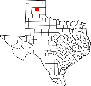
Location within the U.S. state of Texas
|
|
 Texas's location within the U.S. |
|
| Country | |
| State | |
| Founded | 1888 |
| Named for | Samuel Price Carson |
| Seat | Panhandle |
| Largest town | Panhandle |
| Area | |
| • Total | 924 sq mi (2,390 km2) |
| • Land | 920 sq mi (2,400 km2) |
| • Water | 3.9 sq mi (10 km2) 0.4% |
| Population
(2020)
|
|
| • Total | 5,807 |
| • Density | 6.285/sq mi (2.4265/km2) |
| Time zone | UTC−6 (Central) |
| • Summer (DST) | UTC−5 (CDT) |
| Congressional district | 13th |
Carson County is a county located in the U.S. state of Texas. In 2020, about 5,807 people lived there. The main town and county seat is Panhandle. The county was created in 1876 and officially started working in 1888. It is named after Samuel Price Carson, who was the first secretary of state for the Republic of Texas.
Carson County is part of the larger Amarillo area, which is a big city region in Texas.
Contents
History of Carson County
Early People and Explorers
Long ago, prehistoric hunter-gatherers lived in this area. Later, Native American tribes like the Plains Apache and then the Comanches called it home. The Comanches were a powerful tribe. They were eventually defeated by the United States Army in the Red River War of 1874.
A Spanish explorer named Francisco Vásquez de Coronado traveled through the Llano Estacado region in 1541. This was a very long time before the county was even created.
How Carson County Grew
Carson County was officially set up in 1876. It was formed from a much larger area called Bexar County. The county government started in 1888. At that time, Panhandle was the only town, and it became the county seat.
Ranching became very important in the 1880s. Huge ranches, like the JA Ranch, covered vast areas. The Turkey Track Ranch was also started in 1878 by Richard E. McNalty. Some early attempts at large land companies didn't work out. For example, the Francklyn Land and Cattle Company bought a lot of land but later sold it.
Railroads arrived in Carson County around 1886. The Atchison, Topeka and Santa Fe Railway built a line that reached Panhandle City in 1888. This made Panhandle City a key spot for trains. More rail lines were added, connecting the county to other parts of Texas and beyond. These railroads helped the county grow by making it easier to transport goods and people.
Finding water was a challenge. People started using windmills to pump water from underground. This helped solve the water problem for farms and ranches.
In 1909, White Deer became home to Polish Catholic immigrants. They had moved from another part of Texas to settle in Carson County.
Oil and the Pantex Plant
In 1921, Gulf Oil Corporation found oil and gas in Carson County. This was the first time oil was discovered in the Texas Panhandle. A big oil field called Borger field was found in 1925. This led to a lot of oil exploration in the area. By the year 2000, a huge amount of oil had been produced from the county's land.
During World War II, in 1942, the Pantex Ordnance Plant was built in Carson County. It was used to pack and load bombs and shells for the war effort. After the war, it closed for a short time. In 1951, Pantex reopened as a plant that assembles nuclear weapons. Today, Pantex works to keep the nation's nuclear weapons safe and takes apart old weapons.
Geography of Carson County
Carson County covers about 924 square miles. Most of this area is land, with only a small part covered by water.
Main Roads
Neighboring Counties
Carson County shares borders with these counties:
- Hutchinson County (north)
- Roberts County (northeast)
- Gray County (east)
- Donley County (southeast)
- Armstrong County (south)
- Randall County (southwest)
- Potter County (west)
- Moore County (northwest)
People of Carson County
| Historical population | |||
|---|---|---|---|
| Census | Pop. | %± | |
| 1890 | 356 | — | |
| 1900 | 469 | 31.7% | |
| 1910 | 2,127 | 353.5% | |
| 1920 | 3,078 | 44.7% | |
| 1930 | 7,745 | 151.6% | |
| 1940 | 6,624 | −14.5% | |
| 1950 | 6,852 | 3.4% | |
| 1960 | 7,781 | 13.6% | |
| 1970 | 6,358 | −18.3% | |
| 1980 | 6,672 | 4.9% | |
| 1990 | 6,576 | −1.4% | |
| 2000 | 6,516 | −0.9% | |
| 2010 | 6,182 | −5.1% | |
| 2020 | 5,807 | −6.1% | |
| U.S. Decennial Census 1850–2010 2010 2020 |
|||
The population of Carson County has changed over the years. In 2000, there were 6,516 people living there. By 2020, the population was 5,807.
| Race / Ethnicity (NH = Non-Hispanic) | Pop 2000 | Pop 2010 | Pop 2020 | % 2000 | % 2010 | % 2020 |
|---|---|---|---|---|---|---|
| White alone (NH) | 5,904 | 5,473 | 4,873 | 90.61% | 88.53% | 83.92% |
| Black or African American alone (NH) | 38 | 35 | 19 | 0.58% | 0.57% | 0.33% |
| Native American or Alaska Native alone (NH) | 47 | 56 | 46 | 0.72% | 0.91% | 0.79% |
| Asian alone (NH) | 8 | 19 | 19 | 0.12% | 0.31% | 0.33% |
| Pacific Islander alone (NH) | 1 | 0 | 1 | 0.02% | 0.00% | 0.02% |
| Other race alone (NH) | 2 | 0 | 7 | 0.03% | 0.00% | 0.12% |
| Mixed race or Multiracial (NH) | 58 | 74 | 284 | 0.89% | 1.20% | 4.89% |
| Hispanic or Latino (any race) | 458 | 525 | 558 | 7.03% | 8.49% | 9.61% |
| Total | 6,516 | 6,182 | 5,807 | 100.00% | 100.00% | 100.00% |
In 2000, most people in Carson County were White (93.82%). About 7.03% of the population were Hispanic or Latino. The average age in the county was 39 years old.
Towns and Communities
Towns in Carson County
- Groom
- Panhandle (This is the county seat!)
- Skellytown
- White Deer
Unincorporated Community
- Conway (This is a small community not officially part of a town.)
Old Ghost Towns
These are places where people used to live, but now they are mostly empty:
- Cuyler
- Deal
- Lark
Education in Carson County
Students in Carson County attend schools in these districts:
- Groom Independent School District
- Panhandle Independent School District
- Sanford-Fritch Independent School District
- White Deer Independent School District
For college, all of Carson County is served by Amarillo College.
See also
 In Spanish: Condado de Carson para niños
 | Sharif Bey |
 | Hale Woodruff |
 | Richmond Barthé |
 | Purvis Young |

