Carteret, New Jersey facts for kids
Quick facts for kids
Carteret, New Jersey
|
||
|---|---|---|
|
Borough
|
||
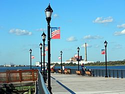
Carteret Waterfront Park
|
||
|
||
| Motto(s):
The Center of it All
|
||
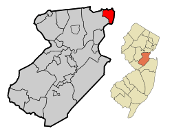
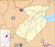
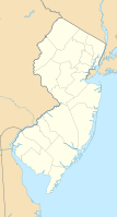
Location of Carteret in Middlesex County highlighted in red (left). Inset map: Location of Middlesex County in New Jersey highlighted in orange (right).
|
||
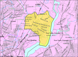
Census Bureau map of Carteret, New Jersey.png
|
||
| Country | ||
| State | ||
| County | Middlesex | |
| Incorporated | April 11, 1906 (as Roosevelt) | |
| Renamed | November 7, 1922 (as Carteret) | |
| Named for | George Carteret and Philip Carteret |
|
| Government | ||
| • Type | borough | |
| • Body | Borough Council | |
| Area | ||
| • Total | 4.93 sq mi (12.77 km2) | |
| • Land | 4.39 sq mi (11.37 km2) | |
| • Water | 0.54 sq mi (1.40 km2) 11.53% | |
| Area rank | 276th of 565 in state 15th of 25 in county |
|
| Elevation | 13 ft (4 m) | |
| Population
(2020)
|
||
| • Total | 25,326 | |
| • Estimate
(2023)
|
25,281 | |
| • Rank | 104th of 565 in state 12th of 25 in county |
|
| • Density | 5,767.7/sq mi (2,226.9/km2) | |
| • Density rank | 96th of 565 in state 8th of 25 in county |
|
| Time zone | UTC−05:00 (Eastern (EST)) | |
| • Summer (DST) | UTC−04:00 (Eastern (EDT)) | |
| ZIP Code |
07008
|
|
| Area code(s) | 732/848 | |
| FIPS code | 3402310750 | |
| GNIS feature ID | 0885181 | |
Carteret is a town, also called a borough, located in Middlesex County, New Jersey. It's in the northeastern part of the state. In 2020, Carteret had a population of 25,326 people. This was the highest number of people living there ever recorded!
Contents
History of Carteret
Carteret started out with a different name. It was first created as the borough of Roosevelt on April 11, 1906. This happened after people voted for it on May 22, 1906.
The name was officially changed to Carteret on November 7, 1922. The borough was named after two important people: Sir George Carteret and his son Philip Carteret. They were early owners of land in New Jersey. Philip Carteret was even the first royal governor of New Jersey.
Geography and Location
Carteret covers about 4.96 square miles (12.86 square kilometers). Most of this area is land, but about 0.57 square miles (1.48 square kilometers) is water.
The Rahway River forms the northern border of Carteret. On the other side of the river is the town of Linden. There's a park area called Joseph Medwick Park along the riverbanks. The Arthur Kill is a waterway that forms the eastern border. Across the Arthur Kill is Staten Island, which is part of New York City. Woodbridge Township surrounds Carteret on all its land borders.
Some smaller areas and neighborhoods within Carteret include Canda, Chrome, East Rahway, Lamar, Silvan Beach, South Carteret, and West Carteret.
Population and People
| Historical population | |||
|---|---|---|---|
| Census | Pop. | %± | |
| 1910 | 5,785 | — | |
| 1920 | 11,047 | 91.0% | |
| 1930 | 13,339 | 20.7% | |
| 1940 | 11,976 | −10.2% | |
| 1950 | 13,030 | 8.8% | |
| 1960 | 20,502 | 57.3% | |
| 1970 | 23,137 | 12.9% | |
| 1980 | 20,598 | −11.0% | |
| 1990 | 19,025 | −7.6% | |
| 2000 | 20,709 | 8.9% | |
| 2010 | 22,844 | 10.3% | |
| 2020 | 25,326 | 10.9% | |
| 2023 (est.) | 25,281 | 10.7% | |
| Population sources: 1910–1920 1910 1910–1930 1940–2000 2000 2010 2020 |
|||
Carteret is home to a large Sikh community. It's the biggest group of Sikhs in New Jersey, with an estimated 1,000 to 2,500 people. The first Sikh temple, called a gurudwara, in the area was in Carteret. It later moved to nearby Port Reading in 2005.
In 2010, there were 22,844 people living in Carteret. The population included people from many different backgrounds. About half of the residents were White, and there were also many Black, Asian, and Hispanic or Latino people.
Economy and Business
Carteret is becoming a hub for film production. A huge film studio complex called Carteret Stages is being built near the waterfront. It will cover 1.2 million square feet and is expected to cost $1 billion.
Parts of Carteret are in an Urban Enterprise Zone (UEZ). This is a special area where businesses get benefits to encourage them to create jobs and invest. Shoppers in these zones can also pay a lower sales tax rate. Carteret became a UEZ in 1995, and this status will continue until March 2026.
The main data center for the NASDAQ OMX Group's stock exchange is located in Carteret. This is where a lot of important computer information for the stock market is stored.
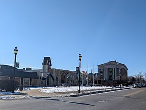
The Carteret Performing Arts Center opened in 2021, offering a place for shows and events.
How Carteret is Governed
Local Government
Carteret is run by a borough government. This is a common way for towns in New Jersey to be governed. The main leaders are the Mayor and the Borough Council.
The mayor is elected by the people for a four-year term. The Borough Council has six members, and they are elected for three-year terms. Two council seats are up for election each year. In Carteret, the mayor leads meetings and can only vote if there's a tie. The mayor also helps decide who serves on different committees.
As of 2023, the mayor of Carteret is Daniel J. Reiman. His term ends on December 31, 2026. The members of the Borough Council are Dennis DiMascio (Council President), Vincent Bellino, Jorge Diaz, Ajmar "AJ" Johal, Randy Krum, and Susan R. Naples.
Emergency Services
Carteret has its own police department with about 50 officers.
The Carteret Volunteer First Aid Squad used to provide emergency medical services, but they stopped operating in April 2013. Now, the EMS (Emergency Medical Services) division of the Carteret Fire Department provides help around the clock.
The Carteret Fire Department has been around for a long time. They hired their first firefighter in the late 1800s. In 2011, the department got its first fireboat. This special boat helps them fight fires along the waterfront.
Education in Carteret
The Carteret School District serves students from pre-kindergarten all the way through twelfth grade. In the 2023–24 school year, the district had about 4,009 students across six schools.
The schools in the district include:
- Columbus School (PreK–4)
- Nathan Hale School (PreK–4)
- Private Nicholas Minue School (PreK–4)
- Carteret Middle School (grades 5–6)
- Carteret Junior High School (grades 7–8)
- Carteret High School (grades 9–12)
Students in eighth grade from all over Middlesex County can also apply to special high school programs. These are offered by the Middlesex County Magnet Schools. They provide career and technical education at different locations.
There is also a private school called Saint Joseph School, which serves students in Pre-K through 8th grade. It is part of Saint Joseph Roman Catholic Church. A private religious college, Yeshiva Gedola of Carteret, opened in 2006.
Getting Around Carteret
Roads and Highways
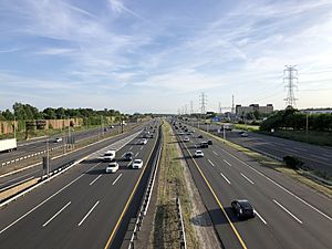
Carteret has many miles of roads. The main highway that goes through Carteret is the New Jersey Turnpike (Interstate 95). Interchange 12 of the turnpike is in Carteret. It was recently updated with more toll lanes and new ramps.
Public Transportation
NJ Transit offers local bus service in Carteret. You can take the 116 bus route to Midtown Manhattan, New York City, or to Perth Amboy. The 48 bus route goes to Elizabeth and Perth Amboy.
There are also plans to start a ferry service from Waterfront Park to Lower Manhattan. This ferry would travel along the Arthur Kill and Kill van Kull waterways. As of 2023, the dredging work was finished, and construction of the dock was underway. The ferry terminal is expected to be completed by Spring 2025.
Famous People from Carteret
Many interesting people have connections to Carteret:
- Jim Babjak, Dennis Diken, and Mike Mesaros from the band The Smithereens used to live in Carteret and met there.
- Jim Conti is from the ska band Streetlight Manifesto.
- Thomas Deverin (1921–2010) was a former mayor of Carteret.
- Keith Hughes (1968–2014) was a basketball player who was drafted by the Houston Rockets.
- Sam Kamara (born 1997) is a professional football player for the Cleveland Browns.
- Chad Kinch (1958–1994) played basketball in the NBA for the Cleveland Cavaliers and Dallas Mavericks.
- Isa Leshko (born 1971) is an artist and author.
- Jim McGreevey (born 1957), a former Governor of New Jersey, grew up in Carteret.
- Art McMahon (born 1946) was a football player for the Boston / New England Patriots.
- Joe "Ducky" Medwick (1911–1975) was a famous baseball player for the St. Louis Cardinals. He is in the Baseball Hall of Fame.
- Nicholas Minue (1905–1943) was a United States Army Private who received the Medal of Honor for his bravery in World War II. An elementary school in Carteret is named after him.
- Paul J. Pluta is a retired Rear Admiral from the United States Coast Guard.
- Joseph Sirola (1929–2019) was an actor known for his voice-over work.
- Joel Weisman (1943–2009) was a doctor who helped identify the pattern of illnesses that became known as AIDS.
- Laurence S. Weiss (circa 1919–2003) was a business executive and politician.
- Jason Worilds (born 1988) is a football player who was drafted by the Pittsburgh Steelers.
See also
 In Spanish: Carteret para niños
 | Selma Burke |
 | Pauline Powell Burns |
 | Frederick J. Brown |
 | Robert Blackburn |


