Cascadia movement facts for kids
Quick facts for kids
Cascadia
|
|
|---|---|
|
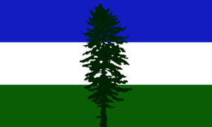
Flag of Cascadia
|
|
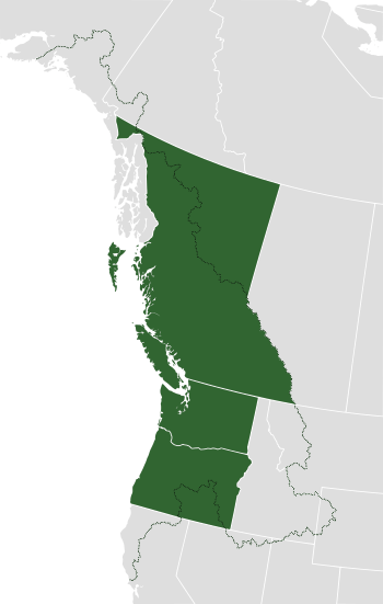
Boundaries of the bioregion with respect to current political divisions (Washington, Oregon and British Columbia).
|
|
| Largest city | Seattle |
| Official languages | English |
| Demonym(s) | Cascadian |
| Area | |
|
• Total
|
1,384,588 km2 (534,592 sq mi) |
| Population | |
|
• 2022 estimate
|
17,250,000 |
|
• 2020 census
|
17,134,999 |
| GDP (PPP) | 2018 estimate |
|
• Total
|
US$1.1 trillion estimate |
|
• Per capita
|
$69,153 estimate |
|
a. *Statistics are compiled from US and Canadian census records by combining information from the states of Washington, Oregon and the province of British Columbia.
|
|
The Cascadia movement is an idea about a special region in western North America. This region is called the Cascadia bioregion. A bioregion is an area defined by its natural environment, like its rivers and mountains, rather than by political borders.
People have different ideas about where Cascadia's borders are. Some think it should follow existing state and province lines. Others believe it should include larger areas based on nature, culture, and economy.
The main parts of Cascadia would be the Canadian province of British Columbia and the US states of Washington and Oregon. Important cities like Seattle, Vancouver, and Portland are in this area. If the whole bioregion is included, Cascadia would stretch from coastal Alaska in the north to Northern California in the south. It would also go inland to parts of Idaho, Montana, Nevada, Utah, Wyoming, and Yukon.
If we only count Washington, Oregon, and British Columbia, Cascadia would have over 17 million people. Its economy would be worth more than US$1.1 trillion each year. This number would be even bigger if parts of Northern California, Idaho, and Southern Alaska were added.
By land area, Cascadia would be one of the largest countries in the world. It would be similar in size to Mongolia and bigger than Peru. Its population would be similar to countries like Ecuador or the Netherlands.
Contents
What is the Cascadia Movement?
The Cascadia movement includes many groups with different goals. Some groups, like the Cascadia Bioregional Party, want the Cascadia bioregion to become independent. Other groups, like the Cascadia Department of Bioregion, want to build a network of bioregions. They see this as a different way to organize society, instead of relying on traditional countries.
There are several reasons why people in the Cascadia movement want to connect with the Pacific Northwest region. They also want to work towards independence. The main reasons include caring for the environment, protecting privacy and freedoms, and improving regional connections. They also want to support local food and economies.
Alexander Baretich, who designed the Cascadia flag, says the movement is not just about breaking away. He believes it's about helping the region survive environmental challenges and other big problems.
Cascadia's Early History
Before the 1800s, over 500,000 Indigenous people lived in the Cascadia region. They belonged to many nations, like the Chinook, Haida, Nootka, and Tlingit. They lived and traded along the rivers and waterways. These waterways were important for travel and trade before European settlers arrived. They spoke many different languages.
Today, many Cascadia and First Nation groups believe in Indigenous sovereignty. This means Indigenous people should have the right to govern themselves. They also believe in the rights of nature and undoing the effects of colonization.
The 1800s
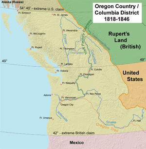
Oregon Country and Columbia District
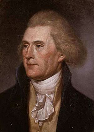
In 1813, Thomas Jefferson wrote a letter about Fort Astoria. This was a fur trading post. Jefferson thought Fort Astoria could be the start of a "great, free, and independent empire" in the West. He believed freedom would spread from there across the continent. However, the same year, Fort Astoria was sold to a British fur trading company.
Other leaders, like John Quincy Adams, also saw the Northwest as a future "empire." Some even thought the region west of the Rocky Mountains would become an independent nation.
In the 1840s, some settlers in the region wanted to form their own country. John McLoughlin, a leader of the Hudson's Bay Company, supported this idea. In 1843, settlers in the Oregon Country held meetings. A majority voted to create an independent republic. However, this plan was put on hold.
Later, the settlers created a Provisional Government. Some people wanted the Oregon Territory to join the United States. Others, like Osborne Russell, wanted it to be a Pacific Republic. This republic would stretch from the Pacific Ocean to the Continental Divide.
In 1846, the British gave up their claims south of the Columbia River to the United States. This was part of the Oregon Treaty. Even after this, some people in the 1860s still talked about creating a "Pacific Republic."
American Civil War Period
During the American Civil War, some people in the Oregon Territory saw a chance for independence. They thought the United States was unstable. However, these independence movements did not succeed.
Adella M. Parker, a leader at the University of Washington, gave a speech in 1894. She said the Pacific Northwest should create its own unique culture. She believed the West should not just copy the East. Instead, it should find its own ideals and way of life.
The 1900s
State of Jefferson
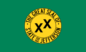
In 1940 and 1941, people in Southern Oregon and Northern California tried to form a new state called Jefferson. They wanted to draw attention to their area. They felt their state governments were not paying enough attention to them. They even blocked a highway and collected tolls. Their flag had a gold pan and two X's, which meant a "double cross" because they felt ignored. This movement ended quickly after the Attack on Pearl Harbor in December 1941.
In 1956, groups from Oregon and California again tried to form the State of Jefferson.
Ecotopia
In 1975, Ernest Callenbach wrote a book called Ecotopia. It was about a secret republic made up of Washington, Oregon, and Northern California. In the story, this republic had broken away from the U.S. 20 years earlier. The book describes a society that lives in a way that protects the environment.
Cascadia and Bioregionalism
The idea of Cascadia is based on bioregionalism. This means that people believe the Cascadia bioregion is a better way to define a place and its people. They feel that current country or state borders divide the land and communities in an unnatural way.
Bioregional Congresses
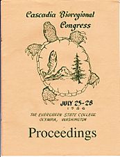
The early Cascadia movement grew from meetings called "Bioregional Congresses" in the 1980s. These meetings brought together people to talk about the region's needs and how it could be governed. The first Cascadia Bioregional Congress was held in 1986 in Olympia, Washington.
Cascadia Bioregion Defined
The Cascadia bioregion is defined by the areas where the Fraser, Snake, and Columbia Rivers flow. It includes parts of Washington, Oregon, Idaho, California, Nevada, Wyoming, Montana, Alaska, British Columbia, and Alberta. It stretches from Cape Mendocino in the south to Mt. St. Alias in the north. It goes as far east as the Yellowstone Caldera.
Bioregions are defined by natural features like rivers and ecosystems. The idea is that political borders should match these natural and cultural boundaries. Many Cascadian bioregionalists use this idea to argue for independence. They believe it would better represent the communities and area.
Cascadian Bioregional Flag
The Cascadian Bioregional Flag is also known as the Doug Flag. It is a common symbol for the Cascadia movement. Alexander Baretich from Portland designed it in 1994. The flag shows the bioregion itself:
- Green represents the forests.
- Blue represents the waters.
- White represents the snow-capped mountains.
- A Douglas Fir tree symbolizes the strength of the region.
Baretich said the flag is not about a country's glory. Instead, it shows a love for the bioregion, its natural boundaries, and the place where people live.
Regional Identity
Many leaders and groups see Cascadia as an economic region that crosses borders. Paul Schell, a former mayor of Seattle, started the "Main Street Cascadia" idea in the early 1990s. This idea focused on the transportation corridor from Eugene, Oregon, to Vancouver, British Columbia. Schell believed Cascadia better represented the culture and geography of this area than states or countries.
Several groups and agencies work together in this region. Since 2008, the Pacific Coast Collaborative has helped coordinate policies. These policies cover environmental issues, managing forests and fisheries, and preparing for emergencies. They also work on transportation and tourism.
The area from Vancouver, B.C., to Portland is seen as a growing "megaregion." This means that the boundaries between cities start to blur. These areas have connected economies, shared natural resources, and common transportation systems. This megaregion has most of Cascadia's population. Programs like the enhanced driver's license make it easier to cross the border between Washington and British Columbia.
Why Some Want Independence
People who support Cascadia's independence often say their reasons are about politics, economy, culture, and nature. They believe that the governments in the east are too far away and slow to respond. They also think these governments stop the region from working together more closely. These connections go back to the Oregon Territory, which was once treated as a single political area.
Some people believe that interest in independence grew after the 2004 US presidential election. More recently, after the 2016 US presidential election, support for Cascadia independence increased again. Some groups formed to explore the idea of Cascadia becoming independent.
Members of the Cascadia independence movement celebrate May 18 as "Cascadia Day." This day remembers the eruption of Mount St. Helens in 1980. The week around this date is called "Cascadia Culture Week."
In British Columbia, the Cascadia Party formed in 2016. They wanted to make the Cascadia bioregion independent.
In May 2021, the Cascadia Bioregional Party was created. It supports Cascadia's independence from the United States and Canada. It also wants social, environmental, and economic changes.
Public Support for Independence
Canada
In British Columbia, a 2020 poll showed more support for Cascadia and for British Columbia becoming an independent country. Support for British Columbia as a standalone country grew to 27%. Younger people (18-34) were more likely to support independence (37%) than older groups.
Support for the idea of joining with Washington and Oregon (Cascadia) was also positive, especially among younger people. About 66% of those aged 18-34 supported this idea.
A 2017-2018 study found that 54% of British Columbians felt they had the most in common with Washington state. Only 15% felt they had the most in common with Alberta, another Canadian province. This shows a strong connection between British Columbia and the US Pacific Northwest.
United States
It's hard to know exact support for Cascadia in Washington and Oregon because specific studies haven't been done. However, support for states leaving the United States is at a high point. A 2021 study found that 47% of Democrats in the Pacific region supported their state joining a new regional union. Overall, 37% of Americans supported the idea of secession.
A 2022 poll found that 52% of people who voted for Trump and 41% of people who voted for Biden agreed that it might be time to split the country into different unions.
Another poll in 2018 found that 39% of Americans supported the idea of independence. Also, 68% were open to a state or region peacefully leaving the United States. This was the highest rate since the American Civil War.
While these studies don't specifically mention Cascadia, they show a growing interest in regions forming their own groups. In 2011, Time magazine listed Cascadia as one of the "Top 10 Aspiring Nations." However, they noted it had "little chance of ever becoming a reality."
See also
 In Spanish: Cascadia para niños
- Secession in the United States
- Secession in Canada
- California Republic, 1846 (California independence movement)
- Cascadia (bioregion)
- Cascadia Cup, a trophy which is awarded each season to the best Major League Soccer team in the Pacific Northwest
- Laurentia (bioregion), another bioregional and cultural region shared by the United States and Canada
- Lincoln (proposed Northwestern state)
- North American integration
- Oregon boundary dispute
 | William Lucy |
 | Charles Hayes |
 | Cleveland Robinson |


