Chester-le-Street facts for kids
Quick facts for kids Chester-le-Street |
|
|---|---|
| Town | |
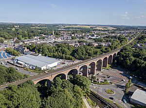 Aerial view of Chester-le-Street |
|
| Population | 24,227 (2011) |
| OS grid reference | NZ270512 |
| Unitary authority |
|
| Ceremonial county | |
| Region | |
| Country | England |
| Sovereign state | United Kingdom |
| Post town | CHESTER LE STREET |
| Postcode district | DH2, DH3 |
| Dialling code | 0191 |
| Police | Durham |
| Fire | County Durham and Darlington |
| Ambulance | North East |
| EU Parliament | North East England |
| UK Parliament |
|
Chester-le-Street is a busy market town in County Durham, England. It's about 6 miles (10 km) north of Durham. The town has markets every Saturday. In 2021, about 23,555 people lived here.
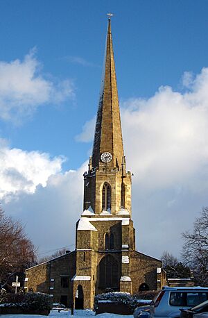
This town has a very old history. Records show it started with a Roman fort called Concangis. The word Chester in the town's name comes from the Latin word castra, which means a Roman fort. The Street part refers to the old paved Roman road that went right through the town from north to south. The local church, St Mary and St Cuthbert, was once home to the body of St Cuthbert for 112 years. Later, his body was moved to Durham Cathedral. In the 10th century, someone named Aldred the Scribe translated the Gospels into Old English right here in Chester-le-Street!
Contents
Exploring Chester-le-Street's Past
How Chester-le-Street Got Its Name
The Romans built a fort here called Concangis. This name came from an older Celtic name for the area. The river that flows through the town, Cong Burn, also got its name from this ancient word. We don't know the exact meaning of Concangis, but some think it might mean "Place of the horse people."
In Old English, the town was called Cuneceastra or Conceastre. This name used the first part of the Roman name and added ceaster, which meant 'Roman fort'. So, the name literally meant "Roman fort on the Cong." Later, it became "Chester upon Street" and then simply "Chester-le-Street."
A Journey Through Time
People lived near the River Wear in this area even in the Iron Age. The Roman fort, Concangis, was built around 100 A.D. next to the Roman road called Cade's Road (which is now Front Street). The Romans stayed until 410 A.D. Back then, the River Wear was deep enough for boats to reach the fort.
After the Romans left, we don't know much until 883 A.D. That's when a group of monks, who had left Lindisfarne, came here. They built a wooden church and shrine for St Cuthbert, whose body they had carried with them. This church became a cathedral, and the monks even translated the famous Lindisfarne Gospels into English here. They stayed for 112 years before moving to Durham in 995 A.D.
The church was rebuilt with stone in 1054. In 1080, many homes in the town were burned down. This happened after an English crowd killed Walcher, who was the first prince-bishop. The area was not even mentioned in the Domesday Book of 1086.
The old Roman road, Cade's Road, continued to be used. It became part of the Great North Road, which was the main route from London to Newcastle and Edinburgh. Because of this road, many inns (like hotels) opened up to serve travelers. This was very busy in the early 1800s with stagecoaches. But then, trains became popular, and the road became less important. Later, the town was bypassed by the A167 road, and then by the A1(M) motorway.
From the late 1600s, coal mining grew in the area. This brought more people to the town, including miners and new businesses like shops and services. These new industries helped Chester-le-Street grow even more.
On October 5, 1936, the Jarrow Marchers stopped in Chester-le-Street after their first day of walking. They stayed in the church hall before continuing their journey the next day.
How the Town is Run
From 1894 to 2009, Chester-le-Street had its own local government. At first, it was a rural district that included the town and nearby villages. Later, the town itself became an urban district. In 1974, these areas joined to form a larger district. This district was then removed in 2009, and County Durham became one big council area.
Weather and Nature
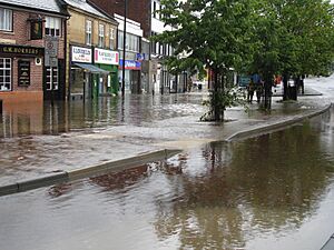
Chester-le-Street has a mild climate and gets less rain than the average for the UK. However, it does sometimes experience floods. The Riverside cricket ground and Riverside Park are built on the River Wear's flood plains. They often get flooded when the river overflows. The town centre can also have flash flooding after very heavy rain. This happens at the bottom of Front Street where the Cong Burn flows under the road.
Famous Places to See
In the 1530s, John Leland said Chester-le-Street was "Chiefly one main street of very mean building in height."
Chester Burn Viaduct
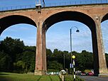
The viaduct is a large bridge for trains northwest of the town centre. It was finished in 1868 for the North Eastern Railway. This allowed trains to travel faster between Newcastle and Durham. It is over 230 meters long and has 11 arches. Today, it goes over a road and a supermarket car park. It is a Grade II listed building, which means it's an important historical structure.
Lumley Castle
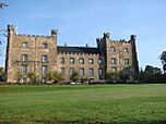
Lumley Castle was built in 1389. It stands on the east side of the River Wear. The castle looks over the town and Riverside Park.
The Queens Head Hotel
The Queens Head Hotel is on Front Street in the middle of town. It was built over 250 years ago. Back then, Front Street was part of the main road from Edinburgh and Newcastle to London. It is a Grade II listed building and is still one of the biggest buildings in the town centre.
The Post Office
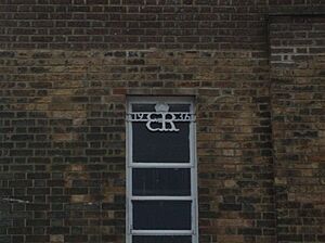
The Chester-le-Street Post Office at 137 Front Street was built in 1936. It has an Art Deco style. What's special about it is that it shows the royal cypher (a special symbol) from the short time Edward VIII was king. There are only a few post offices like this.
Churches and Other Religious Places
St Mary and St Cuthbert Church
St Mary and St Cuthbert church has a very rare 14th-century anchorage. This was a small, walled-up room where anchorites (religious people who lived alone) stayed. They lived there from 1383 to about 1538. The room had only a small slit to see the altar and get food. Outside, there was an open grave for when the person died. Today, it's a museum called the Anker's House. The church also has statues of the Lumley family. These statues are very old, some even cut to fit. This church and Lumley Castle are the only Grade I listed buildings in Chester-le-Street.
Bethel United Reformed Church
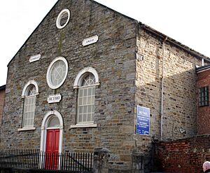
The small United Reformed Church on Low Chare was built in 1814. It was first called the Bethel Congregational Chapel. It was updated in 1860 and is still used today. It is a Grade II listed building.
Sports and Fun
Cricket
The Riverside Ground, also known as the Seat Unique Riverside, is the home of Durham County Cricket Club. This team became a top-level county team in 1992. Since 1999, the ground has hosted many international cricket matches, often involving the England cricket team. It also hosted games during the 1999 Cricket World Cup and the 2019 Cricket World Cup.
Chester-le-Street also has its own cricket club, Chester-le-Street Cricket Club. They play at the Ropery Lane ground. They have won the North East Premier League and a national 45-over tournament in 2009.
Rowing
The Chester-le-Street Amateur Rowing Club is located on the River Wear near the Riverside cricket ground. It has been there for over 100 years. In summer, they row on the river. In winter, they train indoors during the week and use the river on weekends.
The club has more than 160 members, and 90 of them are young people. The club is well-known for helping young rowers get better. Many of their junior members now compete at a national level for Great Britain.
Football
In the past, a game called Medieval football was played in the town. It happened every year on Shrove Tuesday. Two teams, the "Upstreeters" and "Downstreeters," would play. The game started at 1 pm and ended at 6 pm. The ball was thrown from a window in the town centre to start the game. More than 400 players sometimes took part! The middle of the street was the dividing line. The team that had the ball on their side at 6 pm won. This game was played from the Middle Ages until 1932, when the police stopped it.
Today, Chester-le-Street United F.C. was started in 2020. They play in the Northern Football League Division Two. In the 2022/23 season, they finished above their local rivals, Chester-le-Street Town F.C.. Chester-le-Street Town F.C. was founded in 1972 and plays just outside the town in Chester Moor.
Getting Around
Trains
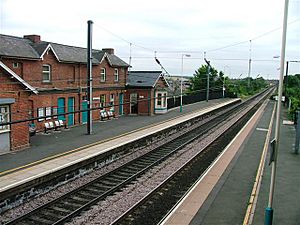
Chester-le-Street railway station is on the East Coast Main Line. This is a major train route between Newcastle and Durham. The station opened in 1868. Two train companies use this station:
- TransPennine Express trains go to places like Liverpool Lime Street, Manchester Piccadilly, Leeds, York, Durham, and Newcastle.
- Northern Trains runs a few services in the early mornings and evenings. These go to Newcastle, Carlisle, and Darlington.
Northern Trains manages the station. The town is even mentioned in the 1963 song "Slow Train" by Flanders and Swann.
Buses
Bus services in Chester-le-Street are mainly run by Go North East and Arriva North East. You can take buses from the town to Newcastle, Durham, Middlesbrough, and Seaham.
Chester-le-Street was where The Northern General Transport Company started. This company later grew into Go North East. They had a depot on Picktree Lane until 2023.
Roads
Front Street used to be part of the A1 road, which connected London and Edinburgh. In the 1950s, a bypass was built, which is now the A167. This bypass was later partly replaced by the A1(M) motorway in the 1970s.
The northern part of Front Street is now closed to most cars. Only buses, cyclists, and delivery vehicles can use it.
Schools in Chester-le-Street
Primary Schools
- Cestria Primary School
- Bullion Lane Primary School
- Woodlea Primary School
- Lumley Junior and Infant School
- Newker Primary School
- Red Rose Primary School
- Chester-le-Street CE Primary School
- St Cuthbert's RCVA Primary School
Secondary Schools
- Park View School
- Hermitage Academy
Famous People from Chester-le-Street
- Michael Barron, footballer
- Aidan Chambers, children's author
- Ellie Crisell, journalist and TV presenter
- Danny Graham, footballer
- Andrew Hayden-Smith, actor and presenter
- Grant Leadbitter, footballer
- Sheila Mackie, artist
- Jock Purdon, folk singer and poet
- Adam Reach, footballer
- Bryan Robson, former England football manager
- Gary Robson, footballer
- Gavin Sutherland, conductor and pianist
- Colin Todd, football manager and former England player
- Bruce Welch of pop group The Shadows
Twin Town
Chester-le-Street is twinned with:
- Kamp-Lintfort in Germany.
 | Delilah Pierce |
 | Gordon Parks |
 | Augusta Savage |
 | Charles Ethan Porter |


