
Point Pleasant Beach, New Jersey facts for kids
Quick facts for kids
Point Pleasant Beach, New Jersey
|
||
|---|---|---|
|
Borough
|
||

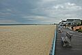
The boardwalk fronting Point Pleasant Beach
|
||
|
||

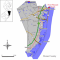
Location of Point Pleasant Beach in Ocean County highlighted in red (right). Inset map: Location of Ocean County in New Jersey highlighted in black (left).
|
||

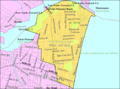
Census Bureau map of Point Pleasant Beach, New Jersey
|
||

Point Pleasant Beach, New Jersey
Location in Ocean County, New Jersey

Point Pleasant Beach, New Jersey
Location in New Jersey

Point Pleasant Beach, New Jersey
Location in the United States
|
||
| Country | ||
| State | ||
| County | ||
| Incorporated | May 18, 1886 | |
| Government | ||
| • Type | Borough | |
| • Body | Borough Council | |
| Area | ||
| • Total | 1.74 sq mi (4.51 km2) | |
| • Land | 1.42 sq mi (3.69 km2) | |
| • Water | 0.32 sq mi (0.82 km2) 18.22% | |
| Area rank | 429th of 565 in state 19th of 33 in county |
|
| Elevation | 7 ft (2 m) | |
| Population
(2020)
|
||
| • Total | 4,766 | |
| • Estimate
(2023)
|
4,897 | |
| • Rank | 386th of 565 in state 15th of 33 in county |
|
| • Density | 3,347.8/sq mi (1,292.6/km2) | |
| • Density rank | 202nd of 565 in state 7th of 33 in county |
|
| Time zone | UTC−05:00 (Eastern (EST)) | |
| • Summer (DST) | UTC−04:00 (Eastern (EDT)) | |
| ZIP Code |
08742
|
|
| Area code(s) | 732 | |
| FIPS code | 3402959910 | |
| GNIS feature ID | 885358 | |
| Website | ||


Point Pleasant Beach is a fun coastal town in New Jersey. It's located right on the Atlantic Ocean in Ocean County. This borough is at the northern tip of the Barnegat Peninsula. This peninsula is a barrier island that separates the ocean from Barnegat Bay. The town's name comes from its beautiful location.
In 2020, about 4,766 people lived here. This was a small increase from 2010. Point Pleasant Beach became an official borough on May 18, 1886. It's a separate town from Point Pleasant, New Jersey, which is just to its west.
The town has a famous boardwalk that is about one mile long. It stretches from the Manasquan Inlet in the north to New Jersey Avenue in the south. The middle part of the boardwalk is full of exciting things. You'll find amusement rides, Jenkinson's Aquarium, arcades, pizza places, and mini-golf. There are fees to get onto the beaches. Parking also costs money.
In 2008, Point Pleasant Beach was named the eighth-best beach in New Jersey. This was part of a contest by the New Jersey Marine Sciences Consortium.
Contents
History of Point Pleasant Beach
Early Days and First Settlers
The land where Point Pleasant Beach now stands was first home to the Lenape Native Americans. In 1609, explorer Henry Hudson sailed by. His crew member, Robert Juet, wrote that it was a "very good Land." The first European settlers arrived in the 1700s. They were mostly fishermen and farmers.
How Tourism Began
Tourism started in the early 1800s. A Quaker named Thomas Cook Jr. opened his farmhouse to visitors. This began the trend of people visiting the area. In the 1870s, Captain John Arnold helped tourism grow even more. He built a road to the ocean, now called Arnold Avenue. In 1875, he built the first bridge over the Manasquan River. This bridge connected the town to Brielle, New Jersey. Captain Arnold also convinced the Central Jersey Railroad to bring train service to Point Pleasant Beach. Trains started arriving on July 3, 1880.
The Borough of Point Pleasant Beach was officially created on June 2, 1886.
Growth of the Boardwalk and Amusements
The 1870s saw a big boom in tourism. Developers bought old farms and sold lots for vacation homes. Captain Arnold created "Arnold City" near the ocean. In 1877, the Point Pleasant Land Company bought a large farm. They built the four-story Resort House, which was the biggest building in town. They also started a horse-drawn trolley for tourists. Many hotels were built, but some later burned down or were taken apart.
At first, visitors enjoyed the river and farmlands. But soon, they wanted to be closer to the ocean. The first beachfront pavilion was built in 1880. Ten years later, a temporary boardwalk was built. However, it washed away in just two years.
The first amusement area was Clark's Landing, which opened in 1892. In 1897, the town decided that beaches should be privately owned. This was because the cost of maintaining them was too high for the borough. In 1915, the first permanent boardwalk was built. It was later shortened by a hurricane in 1938.
The boardwalk became a lively place. Charles Jenkinson built Jenkinson's Pavilion and a swimming pool in the 1920s. This pavilion became a center for fun, with dancing and famous big bands. Today, the boardwalk has many amusement rides, video arcades, and different kinds of food. Point Pleasant Beach also hosts an annual Seafood Festival in September.
Famous Shipwreck and Hurricane Sandy

On February 12, 1900, a large Scottish ship called the County of Edinburgh got stuck on the beach. This event made national news. The ship was successfully refloated two days later.
In October 2012, Hurricane Sandy caused a lot of damage to Point Pleasant Beach. Nearly 2,800 feet of the boardwalk were destroyed. Repairs cost millions of dollars. After the hurricane, a seawall was built to protect the area. Also, homes that were rebuilt had to be raised on pilings. This helps protect them from future storms.

Geography and Location

Point Pleasant Beach covers about 1.74 square miles. Most of this is land, but about 0.32 square miles is water.
Some smaller areas within the borough include Clark's Landing and Sunshine Harbor. Point Pleasant Beach shares borders with several other towns. These include Bay Head, New Jersey and Point Pleasant, New Jersey in Ocean County. It also borders Brielle, New Jersey and Manasquan, New Jersey in Monmouth County.
Local Government
Point Pleasant Beach is run by a borough government. This is a common type of local government in New Jersey. The town is led by a mayor and a borough council. The mayor is elected for a four-year term. The council has six members, each serving three-year terms. Two council seats are up for election each year.
The mayor of Point Pleasant Beach is Doug Vitale. He is a Republican and his term ends in December 2028. The borough council members include Rosa Crowley, Caryn S. Byrnes, Jack Pasola, Art Gant, Michael Ramos, and Arlene Testa.
Education in Point Pleasant Beach
The Point Pleasant Beach School District serves students from pre-kindergarten through twelfth grade. The district has two schools. As of the 2023–24 school year, there were 646 students.
The schools are:
- G. Harold Antrim Elementary School (PreK–8)
- Point Pleasant Beach High School (9–12)
Students from Bay Head, New Jersey and Lavallette, New Jersey also attend Point Pleasant Beach High School. Students from Mantoloking, New Jersey attend both elementary and high school here. This is part of special agreements between the towns.
Transportation Options
Roads and Highways
_just_north_of_Newark_Avenue_in_Point_Pleasant_Beach,_Ocean_County,_New_Jersey.jpg)
Point Pleasant Beach has about 29.66 miles of roads. Most of these are maintained by the town itself.
Route 35 is the main highway. It runs north to south through the borough. This road connects Point Pleasant Beach to Bay Head and Brielle. Route 88 starts in Point Pleasant Beach. It heads west through Point Pleasant and on to Lakewood.
Public Transportation

NJ Transit trains stop at the Point Pleasant Beach station. This station is on Arnold Avenue. You can take the North Jersey Coast Line train north to places like Newark Penn Station, Hoboken Terminal, and New York Penn Station.
NJ Transit also offers bus service. The 317 route goes between the borough and Philadelphia. Local bus service is available on the 830 route. Ocean Ride also provides local bus routes like the OC3A and OC4.
Climate and Weather
Point Pleasant Beach has a humid subtropical climate. This means it has warm, humid summers and mild winters. In summer, a cool sea breeze often blows in the afternoon. However, it can get very hot and humid sometimes. The wettest month is usually July, when there are more thunderstorms. In winter, it can get very cold and windy. The area gets about 18 to 24 inches of snow each year. February is usually the snowiest month.
Notable People
Many interesting people have lived in or are connected to Point Pleasant Beach:
- Evelyn Adams, who won the New Jersey Lottery twice.
- Jason Cairns, a retired American soccer player.
- Jim Carone (born 1981), a college baseball coach.
- Robert (born 1966) and Dean DeLeo (born 1961), musicians from the rock band Stone Temple Pilots, grew up here.
- Matt Farrell (born 1996), a basketball player.
- Katelynn Flaherty (born 1996), a former basketball player for the Michigan Wolverines. She is the school's all-time leading scorer.
- Alfred M. Gray Jr. (born 1928), a former leader of the Marine Corps.
- Dickie Harris (born 1950), an all-star defensive back in Canadian football.
- James W. Holzapfel (born 1944), a member of the New Jersey Senate.
- Leonard Lomell (1920–2011), a U.S. Army Ranger who helped destroy German guns on D-Day.
Images for kids
-
The boardwalk fronting Point Pleasant Beach
-
Location of Point Pleasant Beach in Ocean County highlighted in red (right). Inset map: Location of Ocean County in New Jersey highlighted in black (left).
-
Census Bureau map of Point Pleasant Beach, New Jersey
-

Nightlife at Jenkinson's Boardwalk
-

County of Edinburgh stranded on the beach, February 12–14, 1900
-
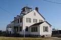
The old Coast Guard Station on Manasqan Inlet, built in 1936
-
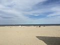
A view of the beach in Point Pleasant Beach
-
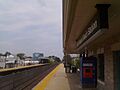
Point Pleasant Beach station, which is served by NJ Transit's North Jersey Coast Line
-
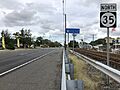
Route 35 northbound in Point Pleasant Beach
See also
 In Spanish: Point Pleasant Beach para niños
