Climate of North Carolina facts for kids
North Carolina has a very interesting climate! It changes a lot from the Atlantic Ocean coast in the east to the Appalachian Mountains in the west. The tall mountains often act like a giant "shield." They help block cold temperatures and big storms coming from the Midwest from reaching the middle part of North Carolina (called the Piedmont) and the flat Coastal Plain.
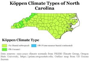
Most of the state has a humid subtropical climate. This means it's usually warm and humid, especially in summer. But in the higher parts of the Appalachian Mountains, the climate is a bit different. It's called a subtropical highland climate, which is cooler.
The state has different plant USDA Hardiness Zones, which tell you what plants can grow there. They range from very cold in the mountains (Zone 5B, -15°F to -10°F) to warmer along the eastern coast (Zone 9A, 20°F to 25°F). In July, daytime temperatures are usually around 90°F (32°C) in most areas. In January, temperatures change a lot across the state. They can be about 40°F (4°C) in the mountains, around 50°F (10°C) in the Piedmont, and close to 60°F (16°C) along the southeastern coast.
Contents
Rain and Snow in North Carolina
North Carolina gets a good amount of rain each year. On average, it's about 45 inches (114 cm), but mountainous areas get more, about 50 inches (127 cm). A lot of this rain happens during summer storms in July. Also, about 15% of the warm-season rain in the Carolinas comes from tropical cyclones, like hurricanes.
The mountains usually get some snow in the fall and winter. Moist winds from the southwest bring a lot of rain, about 80 inches (203 cm), to the western side of the mountains. But the slopes facing northeast get less than half that amount.
| Average monthly precipitation | |||||||||||||
| City | Jan | Feb | Mar | Apr | May | Jun | Jul | Aug | Sep | Oct | Nov | Dec | Total |
|---|---|---|---|---|---|---|---|---|---|---|---|---|---|
| Asheville | 2.6 inches (66 mm) | 3.1 inches (79 mm) | 4 inches (100 mm) | 3.3 inches (84 mm) | 2.9 inches (74 mm) | 3.5 inches (89 mm) | 3.4 inches (86 mm) | 4 inches (100 mm) | 3.1 inches (79 mm) | 2.7 inches (69 mm) | 2.6 inches (66 mm) | 2.7 inches (69 mm) | 38.1 inches (970 mm) |
| Cape Hatteras | 5.6 inches (140 mm) | 4.1 inches (100 mm) | 4.6 inches (120 mm) | 3.2 inches (81 mm) | 3.8 inches (97 mm) | 4.2 inches (110 mm) | 4.9 inches (120 mm) | 6.4 inches (160 mm) | 5.3 inches (130 mm) | 5.3 inches (130 mm) | 4.9 inches (120 mm) | 4.5 inches (110 mm) | 56.9 inches (1,450 mm) |
| Charlotte | 3.7 inches (94 mm) | 3.7 inches (94 mm) | 4.6 inches (120 mm) | 3 inches (76 mm) | 3.6 inches (91 mm) | 3.5 inches (89 mm) | 3.8 inches (97 mm) | 4.1 inches (100 mm) | 3.3 inches (84 mm) | 3.2 inches (81 mm) | 3.1 inches (79 mm) | 3.3 inches (84 mm) | 43 inches (1,100 mm) |
| Greensboro | 3.1 inches (79 mm) | 3 inches (76 mm) | 3.7 inches (94 mm) | 3.6 inches (91 mm) | 3.4 inches (86 mm) | 3.7 inches (94 mm) | 4.5 inches (110 mm) | 3.9 inches (99 mm) | 4.2 inches (110 mm) | 3.1 inches (79 mm) | 3.1 inches (79 mm) | 3 inches (76 mm) | 42.2 inches (1,070 mm) |
| Raleigh | 3.5 inches (89 mm) | 3.5 inches (89 mm) | 3.7 inches (94 mm) | 2.8 inches (71 mm) | 3.8 inches (97 mm) | 3.6 inches (91 mm) | 4.4 inches (110 mm) | 4.4 inches (110 mm) | 3.1 inches (79 mm) | 3 inches (76 mm) | 2.9 inches (74 mm) | 3.1 inches (79 mm) | 41.8 inches (1,060 mm) |
| Wilmington | 3.6 inches (91 mm) | 3.5 inches (89 mm) | 4.3 inches (110 mm) | 2.9 inches (74 mm) | 4.3 inches (110 mm) | 5.4 inches (140 mm) | 7.9 inches (200 mm) | 7 inches (180 mm) | 5.6 inches (140 mm) | 3.3 inches (84 mm) | 3.3 inches (84 mm) | 3.5 inches (89 mm) | 55 inches (1,400 mm) |
How Much Snow Does North Carolina Get?
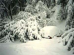
Snow is common in the mountains of North Carolina. On average, the state gets about 5 inches (13 cm) of snow each winter. However, this amount changes a lot depending on where you are. Along the coast, most places get less than 2 inches (5 cm) of snow per year. The state capital, Raleigh, gets about 6 inches (15 cm) on average. Farther west, in the Piedmont-Triad area, the average goes up to about 9 inches (23 cm). The city of Charlotte usually sees about 5 inches (13 cm) of snow.
The town of Boone, located high in the northwestern mountains, gets a lot more snow, about 45 inches (114 cm) each winter! The western mountains act like a wall, stopping most snowstorms from reaching the Piedmont. When snow does get past the mountains, it's usually light and doesn't stay on the ground for long.
However, some big storms have brought much more snow to normally warmer areas. The 1993 Storm of the Century brought huge amounts of snow to North Carolina. Newfound Gap got over 36 inches (91 cm) of snow, with snowdrifts over 5 feet (1.5 m) high! Mount Mitchell measured over 4 feet (1.2 m) of snow, with drifts up to 14 feet (4.3 m). Most of the northwestern part of the state received between 2 and 3 feet (61 to 91 cm) of snow.
Another big snowfall hit the Raleigh area in January 2000, with over 20 inches (51 cm) of snow. The Wilmington area also had a heavy snowfall of 18 inches (46 cm) in December 1989. This storm mostly affected the southeastern US coast. Most large snowstorms that hit areas east of the mountains come from storms that move up from the south. These storms bring moisture over cold air, causing heavy snow.
| Average monthly snowfall | |||||||||||||
| City | Jan | Feb | Mar | Apr | May | Jun | Jul | Aug | Sep | Oct | Nov | Dec | Total |
|---|---|---|---|---|---|---|---|---|---|---|---|---|---|
| Asheville | 4.6 inches (12 cm) | 4.6 inches (12 cm) | 3 inches (7.6 cm) | 0.7 inches (1.8 cm) | - | - | - | - | - | - | 0.7 inches (1.8 cm) | 2 inches (5.1 cm) | 15.6 inches (40 cm) |
| Cape Hatteras | 0.4 inches (1.0 cm) | 0.6 inches (1.5 cm) | 0.4 inches (1.0 cm) | - | - | - | - | - | - | - | - | 0.6 inches (1.5 cm) | 2 inches (5.1 cm) |
| Charlotte | 2 inches (5.1 cm) | 1.7 inches (4.3 cm) | 1.2 inches (3.0 cm) | - | - | - | - | - | - | - | 0.1 inches (0.25 cm) | 0.5 inches (1.3 cm) | 5.5 inches (14 cm) |
| Greensboro | 3.4 inches (8.6 cm) | 2.4 inches (6.1 cm) | 0.8 inches (2.0 cm) | - | - | - | - | - | - | - | 0.1 inches (0.25 cm) | 0.8 inches (2.0 cm) | 7.5 inches (19 cm) |
| Raleigh | 2.2 inches (5.6 cm) | 2.6 inches (6.6 cm) | 1.3 inches (3.3 cm) | - | - | - | - | - | - | - | 0.1 inches (0.25 cm) | 0.8 inches (2.0 cm) | 7 inches (18 cm) |
| Wilmington | 0.4 inches (1.0 cm) | 0.5 inches (1.3 cm) | 0.4 inches (1.0 cm) | - | - | - | - | - | - | - | - | 0.6 inches (1.5 cm) | 1.9 inches (4.8 cm) |
Tropical Storms and Hurricanes
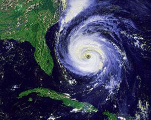
Because North Carolina is on the Atlantic Coast, many tropical cyclones (also known as hurricanes) that form in the Caribbean Sea travel up the coast. These storms can bring strong winds and heavy rain.
On October 15, 1954, Hurricane Hazel hit North Carolina. It was a very powerful Category 4 hurricane. Hazel caused a lot of damage because of its super strong winds. Winds were reported at 140 mph (225 km/h) at Oak Island and 90 mph (145 km/h) in Raleigh. The hurricane caused 19 deaths and destroyed many buildings. It was called "the most destructive storm in the history of North Carolina."
In 1996, Hurricane Fran also hit North Carolina. As a category 3 hurricane, Fran caused a lot of damage, mostly from its strong winds. Fran's winds reached 115 mph (185 km/h), and the coast saw ocean surges of 8 to 12 feet (2.4 to 3.7 m) above normal sea level. The damage from Fran in North Carolina was estimated to be between $1.275 billion and $2 billion.
Heavy Rain from Tropical Storms
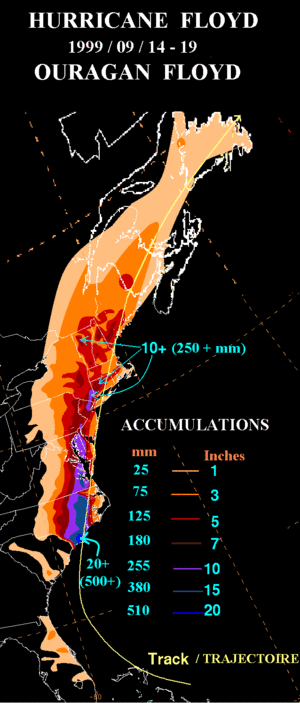
Tropical cyclones and their leftover parts often bring very heavy rains to North Carolina. This happens when they move northeast from the Gulf of Mexico or inland from the Atlantic Ocean. Over the last 30 years, Hurricane Floyd in September 1999 was one of the wettest storms. It dropped over 24 inches (61 cm) of rain north of Southport.
Unlike Hazel and Fran, Hurricane Floyd's main problem was the huge amount of rain it brought, causing massive floods. Before Floyd arrived, North Carolina had already received a lot of rain from Hurricane Dennis just two weeks earlier. This made the ground very wet, so when Hurricane Floyd's heavy rains came, they quickly turned into floods. More than 35 people died because of the flooding from Floyd. In the mountains, Hurricane Frances in September 2004 also brought a lot of rain, with over 23 inches (58 cm) falling on Mount Mitchell.
Dangerous Weather Events
In most years, the biggest money loss from weather in North Carolina comes from severe thunderstorms in the summer. These storms can bring hail and strong winds, causing an average annual loss of over $5 million.
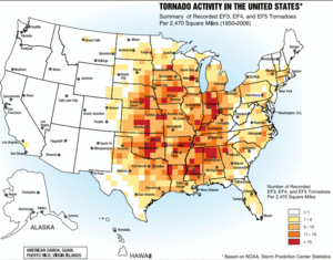
North Carolina usually has about 31 tornadoes a year. May is the month with the most tornadoes, averaging 5. June, July, and August each average 3 tornadoes, and September sees an increase to 4 tornadoes per month. There's a smaller "severe weather season" from September to early November. While the main severe weather season is from March to May, tornadoes have happened in North Carolina in every month of the year.
On November 28, 1988, an early morning F4 tornado tore through northwestern Raleigh. It continued for 84 miles (135 km), killing 4 people and injuring 157. On February 6, 2020, severe storms hit North Carolina. A tornado started in Rowan County, north of Charlotte, and winds reached 30 mph (48 km/h) as it moved north. By 4 PM, 100,000 people had lost power, and flash flood warnings were issued for northern and northwestern areas.
Climate Changes in North Carolina
The coastline of North Carolina is expected to rise between one and four feet (30 to 122 cm) in the next century. This is due to a mix of warming oceans, melting ice, and the land slowly sinking. Temperatures in North Carolina have also been rising. Over the last 100 years, the average temperature in Chapel Hill has gone up by 1.2°F (0.7°C). Also, rainfall in some parts of the state has increased by 5 percent. Around the year 2080, temperatures are likely to go above 95°F (35°C) for about 20 to 40 days per year in most of the state. This is a big jump from about 10 days per year in 2016.
Seasons in North Carolina
Winter Weather
In winter, North Carolina gets some protection from the Appalachian Mountains to its west. Cold air from Canada often loses some of its strength when it crosses the mountains. However, sometimes very cold air can move from the north or northeast, staying east of the mountains. This happens when cold air systems settle over the Northeastern states. Other cold air outbreaks can cross the mountains, making temperatures drop to about 12°F (-11°C) in central North Carolina. But temperatures below zero degrees Fahrenheit are very rare outside of the mountains. The coldest temperature ever recorded in North Carolina was -34°F (-37°C) on January 21, 1985, at Mount Mitchell.
Winter temperatures on the coast are milder because of the warming effect of the Atlantic Ocean and the Gulf Stream. The average ocean temperature in Southport in January is actually warmer than the average ocean temperature in Maine during July! Snow is common in the mountains, and many ski resorts use snowmaking machines to ensure there's always snow. North Carolina's air is most humid in the winter.
Spring Weather
Tornadoes are most likely to happen in the spring. Big tornado outbreaks affected parts of eastern North Carolina on March 28, 1984, and April 16, 2011. May sees the biggest increase in temperatures. During spring, the Piedmont area has warm days and cool nights. Temperatures are a bit cooler in the mountains and warmer near the coast, especially at night. North Carolina's air is least humid in the spring.
Summer Weather
North Carolina has high summer temperatures. Sometimes, cool, dry air from the north will come into North Carolina for short periods, but temperatures quickly warm up again. It stays colder at high elevations, with the average summer temperature on Mount Mitchell being 68°F (20°C). Morning temperatures are usually 20°F (12°C) lower than afternoon temperatures, except right along the Atlantic Coast. The biggest money loss from severe weather in North Carolina comes from severe thunderstorms in the summer, even though they usually only hit small areas. Tropical cyclones can also affect the state during the summer. Fog is also common in the summer.
Fall Weather
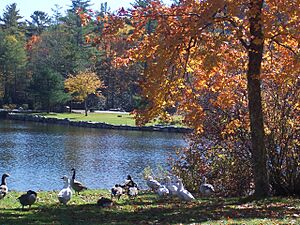
Fall is the season where temperatures change the fastest, especially in October and November. Tropical cyclones can still be a threat until late in the fall. The Appalachian Mountains are a popular place to visit at this time of year because the leaves on the trees change to beautiful colors.
El Niño and La Niña Effects
During El Niño events, winters and early springs are cooler than usual. The central and eastern parts of the state get more rain than average, while the western part is drier. La Niña usually brings warmer temperatures than average. The western part of the state gets more rain, while the central and coastal regions stay drier than average.
Climate Data for North Carolina Cities
| Building | Jan | Feb | Mar | Apr | May | Jun | Jul | Aug | Sep | Oct | Nov | Dec |
|---|---|---|---|---|---|---|---|---|---|---|---|---|
| Asheville | 46/26 | 50/28 | 58/35 | 66/42 | 74/51 | 80/58 | 83/63 | 82/62 | 76/55 | 67/43 | 57/35 | 49/29 |
| Cape Hatteras | 54/39 | 55/39 | 60/44 | 68/52 | 75/60 | 82/68 | 85/73 | 85/72 | 81/68 | 73/59 | 65/50 | 57/43 |
| Charlotte | 51/32 | 56/34 | 64/42 | 73/49 | 80/58 | 87/66 | 90/71 | 88/69 | 82/63 | 73/51 | 63/42 | 54/35 |
| Greensboro | 47/28 | 52/31 | 60/38 | 70/46 | 77/55 | 84/64 | 88/68 | 86/67 | 79/60 | 70/48 | 60/39 | 51/31 |
| Raleigh | 50/30 | 54/32 | 62/39 | 72/46 | 79/55 | 86/64 | 89/68 | 87/67 | 81/61 | 72/48 | 62/40 | 53/33 |
| Wilmington | 56/36 | 60/38 | 66/44 | 74/51 | 81/60 | 86/68 | 90/72 | 88/71 | 84/66 | 76/54 | 68/45 | 60/38 |
| Climate data for Charlotte (Köppen Cfa) | |||||||||||||
|---|---|---|---|---|---|---|---|---|---|---|---|---|---|
| Month | Jan | Feb | Mar | Apr | May | Jun | Jul | Aug | Sep | Oct | Nov | Dec | Year |
| Record high °F (°C) | 79 (26) |
82 (28) |
91 (33) |
96 (36) |
98 (37) |
104 (40) |
104 (40) |
104 (40) |
104 (40) |
99 (37) |
85 (29) |
80 (27) |
104 (40) |
| Mean maximum °F (°C) | 70.6 (21.4) |
73.6 (23.1) |
81.6 (27.6) |
85.9 (29.9) |
90.4 (32.4) |
94.7 (34.8) |
97.0 (36.1) |
96.1 (35.6) |
92.0 (33.3) |
85.6 (29.8) |
77.8 (25.4) |
71.2 (21.8) |
98.0 (36.7) |
| Mean daily maximum °F (°C) | 52.3 (11.3) |
56.6 (13.7) |
64.2 (17.9) |
73.2 (22.9) |
80.1 (26.7) |
86.9 (30.5) |
90.3 (32.4) |
88.6 (31.4) |
82.8 (28.2) |
73.3 (22.9) |
62.9 (17.2) |
54.9 (12.7) |
72.2 (22.3) |
| Daily mean °F (°C) | 42.1 (5.6) |
45.7 (7.6) |
52.7 (11.5) |
61.1 (16.2) |
69.0 (20.6) |
76.6 (24.8) |
80.1 (26.7) |
78.6 (25.9) |
72.7 (22.6) |
61.9 (16.6) |
51.4 (10.8) |
44.7 (7.1) |
61.4 (16.3) |
| Mean daily minimum °F (°C) | 31.8 (−0.1) |
34.9 (1.6) |
41.2 (5.1) |
49.1 (9.5) |
58.0 (14.4) |
66.2 (19.0) |
69.9 (21.1) |
68.7 (20.4) |
62.6 (17.0) |
50.4 (10.2) |
39.8 (4.3) |
34.5 (1.4) |
50.6 (10.3) |
| Mean minimum °F (°C) | 14.8 (−9.6) |
19.3 (−7.1) |
23.7 (−4.6) |
32.9 (0.5) |
43.3 (6.3) |
55.5 (13.1) |
62.2 (16.8) |
60.0 (15.6) |
49.8 (9.9) |
33.9 (1.1) |
23.8 (−4.6) |
19.6 (−6.9) |
12.6 (−10.8) |
| Record low °F (°C) | −5 (−21) |
−5 (−21) |
4 (−16) |
21 (−6) |
32 (0) |
45 (7) |
53 (12) |
50 (10) |
38 (3) |
24 (−4) |
11 (−12) |
−5 (−21) |
−5 (−21) |
| Average precipitation inches (mm) | 3.49 (89) |
3.13 (80) |
3.95 (100) |
3.84 (98) |
3.36 (85) |
3.99 (101) |
3.74 (95) |
4.35 (110) |
3.71 (94) |
3.16 (80) |
3.31 (84) |
3.57 (91) |
43.60 (1,107) |
| Average snowfall inches (cm) | 1.6 (4.1) |
1.1 (2.8) |
0.3 (0.76) |
0.0 (0.0) |
0.0 (0.0) |
0.0 (0.0) |
0.0 (0.0) |
0.0 (0.0) |
0.0 (0.0) |
0.0 (0.0) |
0.1 (0.25) |
0.4 (1.0) |
3.5 (8.9) |
| Average precipitation days (≥ 0.01 in) | 10.3 | 9.7 | 10.2 | 9.0 | 9.5 | 10.6 | 10.5 | 10.1 | 7.7 | 7.1 | 8.1 | 9.6 | 112.4 |
| Average snowy days (≥ 0.1 in) | 0.9 | 0.5 | 0.2 | 0.0 | 0.0 | 0.0 | 0.0 | 0.0 | 0.0 | 0.0 | 0.0 | 0.3 | 1.9 |
| Average relative humidity (%) | 65.7 | 61.8 | 61.5 | 59.3 | 66.9 | 69.6 | 72.2 | 73.5 | 73.3 | 69.9 | 67.6 | 67.3 | 67.4 |
| Average dew point °F (°C) | 27.3 (−2.6) |
28.6 (−1.9) |
36.3 (2.4) |
43.5 (6.4) |
54.9 (12.7) |
63.0 (17.2) |
67.1 (19.5) |
66.7 (19.3) |
61.2 (16.2) |
49.5 (9.7) |
39.6 (4.2) |
31.3 (−0.4) |
47.4 (8.6) |
| Mean monthly sunshine hours | 173.3 | 180.3 | 234.8 | 269.6 | 292.1 | 289.2 | 290.0 | 272.9 | 241.4 | 230.5 | 178.4 | 168.5 | 2,821 |
| Percent possible sunshine | 55 | 59 | 63 | 69 | 67 | 66 | 66 | 65 | 65 | 66 | 58 | 55 | 63 |
| Average ultraviolet index | 3 | 4 | 6 | 8 | 9 | 10 | 10 | 9 | 8 | 5 | 3 | 2 | 6 |
| Source 1: NOAA (relative humidity and sun 1961–1990) | |||||||||||||
| Source 2: Weather Atlas (UV index) | |||||||||||||
| Climate data for Raleigh (Köppen Cfa) | |||||||||||||
|---|---|---|---|---|---|---|---|---|---|---|---|---|---|
| Month | Jan | Feb | Mar | Apr | May | Jun | Jul | Aug | Sep | Oct | Nov | Dec | Year |
| Record high °F (°C) | 80 (27) |
84 (29) |
94 (34) |
95 (35) |
99 (37) |
105 (41) |
105 (41) |
105 (41) |
104 (40) |
100 (38) |
88 (31) |
81 (27) |
105 (41) |
| Mean maximum °F (°C) | 71.9 (22.2) |
74.4 (23.6) |
81.6 (27.6) |
86.4 (30.2) |
91.3 (32.9) |
96.6 (35.9) |
98.2 (36.8) |
96.7 (35.9) |
92.3 (33.5) |
86.7 (30.4) |
78.5 (25.8) |
72.8 (22.7) |
99.6 (37.6) |
| Mean daily maximum °F (°C) | 51.9 (11.1) |
55.8 (13.2) |
63.3 (17.4) |
72.7 (22.6) |
80.0 (26.7) |
87.4 (30.8) |
90.8 (32.7) |
88.7 (31.5) |
82.5 (28.1) |
73.0 (22.8) |
63.0 (17.2) |
54.7 (12.6) |
72.0 (22.2) |
| Daily mean °F (°C) | 41.9 (5.5) |
45.0 (7.2) |
51.8 (11.0) |
60.8 (16.0) |
68.8 (20.4) |
76.7 (24.8) |
80.5 (26.9) |
78.8 (26.0) |
72.6 (22.6) |
61.7 (16.5) |
51.5 (10.8) |
44.6 (7.0) |
61.2 (16.2) |
| Mean daily minimum °F (°C) | 31.8 (−0.1) |
34.2 (1.2) |
40.3 (4.6) |
48.9 (9.4) |
57.7 (14.3) |
66.0 (18.9) |
70.2 (21.2) |
68.9 (20.5) |
62.7 (17.1) |
50.3 (10.2) |
40.0 (4.4) |
34.4 (1.3) |
50.4 (10.2) |
| Mean minimum °F (°C) | 14.0 (−10.0) |
19.2 (−7.1) |
23.7 (−4.6) |
32.2 (0.1) |
42.8 (6.0) |
54.2 (12.3) |
61.0 (16.1) |
58.7 (14.8) |
48.7 (9.3) |
33.2 (0.7) |
24.4 (−4.2) |
19.9 (−6.7) |
12.1 (−11.1) |
| Record low °F (°C) | −9 (−23) |
−2 (−19) |
11 (−12) |
23 (−5) |
29 (−2) |
38 (3) |
48 (9) |
46 (8) |
37 (3) |
19 (−7) |
11 (−12) |
0 (−18) |
−9 (−23) |
| Average precipitation inches (mm) | 3.43 (87) |
2.78 (71) |
4.10 (104) |
3.53 (90) |
3.58 (91) |
3.89 (99) |
5.02 (128) |
4.71 (120) |
5.15 (131) |
3.37 (86) |
3.32 (84) |
3.39 (86) |
46.07 (1,170) |
| Average snowfall inches (cm) | 2.6 (6.6) |
1.4 (3.6) |
0.3 (0.76) |
0.0 (0.0) |
0.0 (0.0) |
0.0 (0.0) |
0.0 (0.0) |
0.0 (0.0) |
0.0 (0.0) |
0.0 (0.0) |
0.1 (0.25) |
0.8 (2.0) |
5.2 (13) |
| Average precipitation days (≥ 0.01 in) | 10.1 | 9.3 | 10.7 | 9.5 | 9.9 | 11.2 | 11.7 | 10.7 | 9.0 | 7.6 | 8.2 | 9.7 | 117.6 |
| Average snowy days (≥ 0.1 in) | 1.2 | 1.2 | 0.4 | 0.0 | 0.0 | 0.0 | 0.0 | 0.0 | 0.0 | 0.0 | 0.1 | 0.5 | 3.4 |
| Average relative humidity (%) | 66.5 | 64.1 | 63.0 | 61.7 | 71.1 | 73.6 | 76.0 | 77.9 | 77.1 | 73.3 | 69.1 | 68.5 | 70.2 |
| Average dew point °F (°C) | 26.8 (−2.9) |
28.2 (−2.1) |
35.8 (2.1) |
43.3 (6.3) |
55.2 (12.9) |
63.5 (17.5) |
67.8 (19.9) |
67.5 (19.7) |
61.5 (16.4) |
49.3 (9.6) |
39.4 (4.1) |
31.1 (−0.5) |
47.5 (8.6) |
| Mean monthly sunshine hours | 163.8 | 173.1 | 228.9 | 250.7 | 258.4 | 267.7 | 259.5 | 239.6 | 217.6 | 215.4 | 174.0 | 157.6 | 2,606.3 |
| Percent possible sunshine | 53 | 57 | 62 | 64 | 59 | 61 | 58 | 57 | 58 | 62 | 56 | 52 | 59 |
| Average ultraviolet index | 3 | 4 | 6 | 7 | 9 | 10 | 10 | 9 | 8 | 5 | 3 | 2 | 6 |
| Source 1: NOAA (relative humidity, dew point, and sun 1961–1990) | |||||||||||||
| Source 2: Weather Atlas (UV Index) | |||||||||||||
 | Valerie Thomas |
 | Frederick McKinley Jones |
 | George Edward Alcorn Jr. |
 | Thomas Mensah |


