
Coalinga, California facts for kids
Quick facts for kids
Coalinga, California
|
|||
|---|---|---|---|
| City of Coalinga | |||

Coalinga City Hall
|
|||
|
|||
| Motto(s):
"The Sunny Side of the Valley"
|
|||

Location of Coalinga in Fresno County, California
|
|||

Coalinga, California
Location in California

Coalinga, California
Location in the United States
|
|||
| Country | United States | ||
| State | California | ||
| County | Fresno | ||
| Incorporated | April 3, 1906 | ||
| Area | |||
| • Total | 6.88 sq mi (17.81 km2) | ||
| • Land | 6.85 sq mi (17.73 km2) | ||
| • Water | 0.03 sq mi (0.08 km2) 0.50% | ||
| Elevation | 673 ft (205 m) | ||
| Population
(2020)
|
|||
| • Total | 17,590 | ||
| • Density | 2,569.01/sq mi (991.85/km2) | ||
| Time zone | UTC−8 (PST) | ||
| • Summer (DST) | UTC−7 (PDT) | ||
| ZIP Code |
93210
|
||
| Area code(s) | 559 | ||
| FIPS code | 06-14274 | ||
| GNIS feature IDs | 1652687, 2409495 | ||


Coalinga is a city in Fresno County, located in the western part of the San Joaquin Valley. It's in central California, about 80 miles (128 km) southeast of Salinas.
The city was once known by names like Coaling Station A and Coalingo. In 2020, about 17,590 people lived there.
Contents
Discovering Coalinga's Past
How Coalinga Got Its Name
Long ago, steam locomotives needed coal to run. The Southern Pacific Railroad set up a place in 1888 where trains could stop and get coal. They called it "Coaling Station A."
People say a railroad official added an "a" to make the name sound nicer. Another idea is that the small signs on the railway just shortened "Coaling A" to "COALINGA." The city officially became a city in 1906.

Major Events in Coalinga's History
- 19th Century Legends: A famous bandit named Joaquin Murrieta was believed to have been killed near Coalinga in 1853. A special landmark marks the spot where this event is thought to have happened.
- Oil and Growth: The area around Coalinga has a lot of oil, known as the Coalinga Oil Field. Companies like Chevron have been drilling for oil here for over a hundred years. This industry has been very important for the city's jobs and economy.
- The 1983 Earthquake: On May 2, 1983, a strong earthquake with a magnitude of 6.5 hit Coalinga. It caused a lot of damage, destroying many homes and buildings, especially in the downtown area. Luckily, only one person passed away from a heart attack during the event.
- Water Challenges: In 2022, Coalinga faced a serious water shortage because its only water source, an aqueduct, was running low. However, heavy statewide floods that winter helped solve the problem, bringing much-needed water.
Exploring Coalinga's Location
Where is Coalinga?
Coalinga is located about 52 miles (84 km) southwest of Fresno. It sits at an elevation of about 673 feet (205 meters) above sea level. The land around Coalinga is mostly flat, which is good for growing crops. It's also near the eastern hills of the Diablo Range.
Understanding Coalinga's Geology
Below Coalinga, there are interesting rock formations, including Vaqueros sandstone. The city is surrounded by areas where large amounts of oil are found, forming the Coalinga Oil Field.
Coalinga is also close to the San Andreas Fault, which is a very active fault line. This means that small earthquakes happen often in the area.
Coalinga's Climate and Weather
Coalinga has a cold semi-arid climate. This means it has very hot summers and cool winters. The average rainfall is about 8.18 inches (208 mm) per year, mostly falling between October and May.
| Climate data for Coalinga, California, 1991–2020 normals, extremes 1942–2022 | |||||||||||||
|---|---|---|---|---|---|---|---|---|---|---|---|---|---|
| Month | Jan | Feb | Mar | Apr | May | Jun | Jul | Aug | Sep | Oct | Nov | Dec | Year |
| Record high °F (°C) | 80 (27) |
87 (31) |
93 (34) |
101 (38) |
110 (43) |
114 (46) |
118 (48) |
114 (46) |
115 (46) |
103 (39) |
91 (33) |
79 (26) |
118 (48) |
| Mean maximum °F (°C) | 70.9 (21.6) |
76.6 (24.8) |
84.6 (29.2) |
91.8 (33.2) |
100.5 (38.1) |
107.1 (41.7) |
109.0 (42.8) |
108.3 (42.4) |
105.0 (40.6) |
95.6 (35.3) |
81.6 (27.6) |
71.5 (21.9) |
110.5 (43.6) |
| Mean daily maximum °F (°C) | 59.7 (15.4) |
65.2 (18.4) |
71.5 (21.9) |
77.5 (25.3) |
86.5 (30.3) |
94.8 (34.9) |
100.8 (38.2) |
100.3 (37.9) |
94.7 (34.8) |
83.3 (28.5) |
69.6 (20.9) |
60.2 (15.7) |
80.3 (26.8) |
| Daily mean °F (°C) | 49.0 (9.4) |
52.8 (11.6) |
58.0 (14.4) |
63.1 (17.3) |
71.1 (21.7) |
78.6 (25.9) |
84.8 (29.3) |
83.5 (28.6) |
77.9 (25.5) |
67.6 (19.8) |
55.9 (13.3) |
48.8 (9.3) |
65.9 (18.8) |
| Mean daily minimum °F (°C) | 38.2 (3.4) |
40.5 (4.7) |
44.6 (7.0) |
48.7 (9.3) |
55.7 (13.2) |
62.5 (16.9) |
68.8 (20.4) |
66.8 (19.3) |
61.1 (16.2) |
52.0 (11.1) |
42.2 (5.7) |
37.3 (2.9) |
51.5 (10.8) |
| Mean minimum °F (°C) | 28.0 (−2.2) |
30.7 (−0.7) |
34.6 (1.4) |
38.5 (3.6) |
45.3 (7.4) |
51.6 (10.9) |
59.8 (15.4) |
58.7 (14.8) |
51.1 (10.6) |
41.3 (5.2) |
31.9 (−0.1) |
27.3 (−2.6) |
25.5 (−3.6) |
| Record low °F (°C) | 17 (−8) |
21 (−6) |
24 (−4) |
30 (−1) |
35 (2) |
38 (3) |
44 (7) |
47 (8) |
41 (5) |
29 (−2) |
24 (−4) |
11 (−12) |
11 (−12) |
| Average precipitation inches (mm) | 1.95 (50) |
1.76 (45) |
1.53 (39) |
0.37 (9.4) |
0.32 (8.1) |
0.11 (2.8) |
0.02 (0.51) |
0.01 (0.25) |
0.06 (1.5) |
0.33 (8.4) |
0.50 (13) |
1.22 (31) |
8.18 (208.96) |
| Average precipitation days (≥ 0.01 in) | 7.1 | 7.7 | 5.1 | 3.2 | 1.7 | 0.4 | 0.1 | 0.1 | 0.4 | 1.9 | 2.6 | 6.2 | 36.5 |
| Source 1: NOAA | |||||||||||||
| Source 2: National Weather Service | |||||||||||||
Coalinga's Economy and Education
What are Coalinga's Main Industries?
Coalinga's economy relies on a few key areas:
- Agriculture: Farming is important here.
- Oil: The Coalinga Oil Field is a major source of jobs.
- Education: Schools and colleges provide many opportunities.
- Correctional Facilities: Pleasant Valley State Prison and Coalinga State Hospital are also big employers. Coalinga State Hospital opened in 2005 and was California's first new mental health hospital in over 50 years.
Learning in Coalinga

Coalinga is home to Coalinga College (also known as West Hills College-Coalinga), which is part of the California Community Colleges system. Younger students attend schools within the Coalinga-Huron Joint Unified School District, which includes Coalinga High School.
People of Coalinga: Demographics
| Historical population | |||
|---|---|---|---|
| Census | Pop. | %± | |
| 1910 | 4,199 | — | |
| 1920 | 2,934 | −30.1% | |
| 1930 | 2,851 | −2.8% | |
| 1940 | 5,026 | 76.3% | |
| 1950 | 5,539 | 10.2% | |
| 1960 | 5,965 | 7.7% | |
| 1970 | 6,161 | 3.3% | |
| 1980 | 6,593 | 7.0% | |
| 1990 | 8,212 | 24.6% | |
| 2000 | 11,668 | 42.1% | |
| 2010 | 13,380 | 14.7% | |
| 2020 | 17,590 | 31.5% | |
| U.S. Decennial Census | |||
Who Lives in Coalinga?
In 2010, Coalinga had a population of 13,380 people. The city is quite diverse.
- About 57.8% of the people were White.
- About 4.1% were African American.
- About 1.3% were Native American.
- About 3.0% were Asian.
- About 29.4% were from other races.
- About 53.5% of the population identified as Hispanic or Latino.

The average age in Coalinga in 2010 was about 31.9 years old. Many families live in Coalinga, with about 46.4% of households having children under 18.
Fun Things to Do in Coalinga
Annual Events and Festivals
- Horned Toad Derby: This fun event happens every year in late May. It's like the famous Jumping Frog Jubilee, but instead of frogs, they use local horned toads (lizards)! This tradition started in 1935.
- WHAMOBASS Balloon Rally: Coalinga hosts this hot air balloon rally every November. It's the longest-running annual hot air balloon event in the world! Over 40 balloons usually take off at sunrise from West Hills College Coalinga.
Museums and Outdoor Activities
- R.C. Baker Memorial Museum: This museum is in an old machine shop. It shows off local fossils, models of ancient animals, Native American tools, and items from early settlers. There's even a restored 1934 Richfield gas station on the property.
- Coalinga Rifle Club: If you like shooting sports, this club has a large range for rifles, pistols, and shotguns. It hosts many state rifle championships and has even been used for training by the Navy SEALs.
- Northern California Aerobatic Contest: The New Coalinga Municipal Airport hosts this exciting event every June. You can watch over 45 pilots perform amazing aerobatic stunts in their planes!
- Harris Ranch: Located about 13 miles northeast of Coalinga, this is a large cattle ranch. It has a hotel, several restaurants, and a gift shop, making it a popular stop for travelers.
Getting Around Coalinga

Coalinga is located where two main roads meet: California State Route 198 and California State Route 33.
For public transport, the Fresno County Rural Transit Agency offers bus service between Coalinga and Fresno from Monday to Saturday. These buses also stop at the Fresno Amtrak station and Fresno International Airport. You can also catch a FlixBus from the ARCO station, which travels to Los Angeles and the Bay Area.
The city also owns the New Coalinga Municipal Airport, which is just east of town.
Famous People from Coalinga
- Jeffrey L. Bannister: A U.S. Army major general who was born in Coalinga.
- Stanley George "Frenchy" Bordagaray: A professional baseball player.
- Hal Finney: A computer scientist known for his work that helped create bitcoin.
- John McCollum: A famous opera singer.
- Daryl Patterson: A professional baseball pitcher.
- Jo Stafford: A well-known singer and TV personality who won a Grammy Award.
- Pat and Lolly Vegas: Musicians and vocalists from the rock band Redbone. They were honored in the Native American Music Hall of Fame in 2008.
Images for kids
-
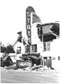
State Theater on Elm Avenue, damaged by the 1983 earthquake

See also
 In Spanish: Coalinga para niños
