Comala facts for kids
Quick facts for kids
Comala
|
||
|---|---|---|
|
Town & Municipality
|
||
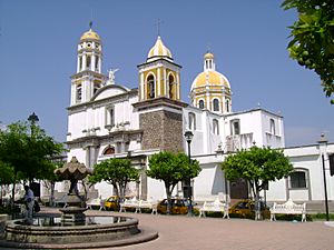
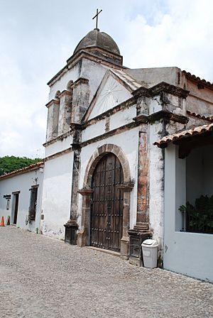
Main plaza and church
|
||
|
||
| Country | ||
| State | Colima | |
| Founded | 1550s | |
| Municipal Status | 1856 | |
| Area | ||
| • Municipality | 254 km2 (98 sq mi) | |
| Elevation
(of seat)
|
600 m (2,000 ft) | |
| Population
(2010) Municipality
|
||
| • Municipality | 20,888 | |
| • Seat | 9,442 | |
| Time zone | UTC-6 (Central (US Central)) | |
| • Summer (DST) | UTC-5 (Central) | |
| Postal code (of seat) |
28450
|
|
| Area code(s) | 312 | |
Comala is a town and municipality in the Mexican state of Colima. It is close to the state capital, also called Colima. People call Comala the "White Village of America." This is because all the buildings in town have been painted white since the 1960s.
The old part of the town is a special "Historic Monument Zone." In 2002, Comala also became a Pueblo Mágico, which means "Magical Town." This title is given to towns that have special natural beauty, cultural richness, or historical importance. Comala is the main town for the Comala Municipality. This municipality includes over 400 other smaller communities. One of these is the old Nogueras Hacienda, which was the home of the famous artist Alejandro Rangel Hidalgo.
Contents
Comala Municipality: What It Is
The town of Comala is the center of the Comala Municipality. This municipality is like a local government area. It includes the town of Comala and more than 400 other small communities. The whole area covers about 254 square kilometers. Long ago, this area was called Ajuchitlán, or "Valley of the Flowers." Native people lived here, close to the water flowing from the Colima Volcano.
Besides the main town, some important communities in the municipality are Suchitlán, Zacualpan, and Cofradía de Suchitlán. The local government has a president, a secretary, and several other officials. The municipality shares borders with other areas like Cuauhtémoc, Minatitlán, and Villa de Álvarez. The state of Jalisco is to the north.
People and Education
In 2005, only a small number of people (68) in the municipality spoke an indigenous language. Most of these people spoke Nahuatl or Maya. You can find Nahuatl speakers in Suchitlán and Zacualpan. The population of the municipality grew quite a bit from 1980 to 2005. Most people (over 97%) in Comala are Catholic. There is also a small group of Evangelist Christians.
Most homes in the municipality are owned by the people who live in them. Over 90% of the people have basic services like running water, streetlights, and trash collection. About 75% have police services, and 80% have paved roads. The municipality has many schools: 17 preschools, 30 primary schools, 7 middle schools, 3 high schools, and 1 vocational school. Very few people over 15 years old cannot read or write.
Roads and Transportation
The main road in the municipality is a four-lane road. It stretches for about 6.5 kilometers from Villa de Alvarez. Another important road connects the main town to the San Antonio hacienda. It also links to the communities of Suchitlán, Cofradía de Suchitlán, and La Nogalera. This road then goes north into Jalisco. The state highway also passes through, connecting to Zacualpan. There are also about 20 kilometers of dirt roads, mostly in smaller communities.
Cultural Places and Museums
The Nogueras Cultural Center is part of the University of Colima. It has an area that shows off ancient pottery from the region.
Other old buildings are also important historical sites. These include the Nogueras Church from the 1700s and the old Nogueras hacienda from the 1800s. The San Antonio hacienda and its water system from the 1800s are also historic. The main church, the municipal palace, and the Los Aguajes Bridge are from the early 1900s.
The Zacualpan Cultural Center was built in 1996. It tells the story of the community and its native identity. You can see old farming tools, weapons from the Mexican Revolution, and parts of an old railroad. There are also stories from the Cristero War. The center has information about a local hero named Indio Alonso and photos of medicinal plants.
The Suchitlán Community Museum was created by the local people and government. It is in the arches next to the main garden in the community. It has murals of the town, wooden masks, old tools, and musical instruments. You can also see dolls that represent traditional dances. The museum also has papers about how the Suchitlán ejido (community land) was set up.
Festivals and Traditions
Local festivals celebrate different saints. These include the Virgin of Candelaria in Suchitlán on February 2. Saint James is celebrated on January 25, and Isidor the Laborer on May 15 in Zacualpan.
Suchitlán is famous for its traditional dances. Some of these are called “morenos,” “gallitas,” “negros,” “sonjaeros,” and “del rebozo.” Zacualpan has a special dance called the Danza de Conquista. Suchitlán also has an annual carnival. People enjoy special foods and drinks like nejayote and pinole. The carnival opening has people with crowns and necklaces made of bread and flowers. They give speeches, and sometimes special guests like Rigoberta Menchú attend.
During festivals in Comala, women often dress in traditional native clothes. They form a parade to announce rodeos, called jaripeos. They also celebrate an event called Día de los Hijos Ausentes, or "Day of the Absent Children." In La Caja, dancing horses perform with music during a festival. In many places in the municipality, Independence Day is celebrated with horse and foot races for all ages. During the Feast of Saint John in Zacualpan, winners get prizes like pigs, hens, and turkeys.
Modern pop and norteño music are popular here. However, there are also nine well-known bands that play traditional music with wind instruments. This music is often played at bullfights.
The Town of Comala
Comala used to be a small farming village. At the start of the 1900s, it only had three streets around the main square. The town is also linked to Juan Rulfo’s famous novel Pedro Páramo. It's not known if Rulfo was writing about this exact town.
The town is still surrounded by farms growing papaya, banana, mamey, and almonds. Orange and palm trees decorate the town itself. You can see the Volcano of Colima from Comala. Many old buildings, especially downtown, have walls made of adobe (a type of mud brick). Many houses have small flower gardens with iron fences.
In 1988, the historic center of Comala was declared a special "Historic Monument Zone." Its streets are paved with river stones. In 1961, the town decided to paint all its buildings white. This helped it stand out from other nearby communities. Today, it is known for its white walls and red tile roofs.
The Main Square
The town centers around a main square, or plaza, named after Benito Juárez. It has been updated many times over the years. In the middle of the plaza is a white kiosk. It has a stone base and a metal roof, built in the early 1900s. Around the kiosk are gardens with palm trees and rose bushes. There are also four fountains and Gothic-style iron benches. These benches were made by the artist Alejandro Rangel Hidalgo.
On two sides of the square, there are covered walkways with businesses. These shops sell local products, and restaurants serve local food. One famous dish is tatemado, which is pork in a thick sauce made with guajillo chili peppers. You can also find pozole and white menudo (a type of soup).
Local Drinks
A very important drink sold here is ponche. Families in Comala have been making it for generations. At least twenty families make it openly, and probably more do so secretly. This drink is so special that it has a "certification of origin." This means that any product called “ponche de Comala” must actually come from this area, just like tequila. Ramon Salazar Salazar was one of the first people to make ponche. His son, Ramiro Salazar Trujillo, still continues the tradition.
Ponche comes in many flavors, at least fourteen! The most traditional ones are pomegranate, coconut, and nuts like pistachio and almond. Other popular flavors include coffee, peanut, tamarind, blackberry, plum, and rompope (a type of eggnog). Another local drink is called bate. It is a type of atole (a warm corn-based drink) served with ice made from sugar cane.
Important Buildings
Also facing the main square are the municipal palace and the main church. The municipal palace was built in the early 1900s. It has a clock and the coat of arms of the municipality. The clock in the tower was replaced in 2000 after some debate. The building is a historic site, and there was a discussion about whether the work should happen. In the end, the new clock was put in, and the old one was saved.
The main church is called San Miguel del Espiritu Santo. The current building was built in the early 1900s. The arch leading into the churchyard is older, from 1832. One unique thing about the church is that one of its towers is not finished. Between the two towers, there is a white statue of the Archangel Michael.
Comala became a Pueblo Mágico in 2002. Since 2006, it has spent about ten million pesos (Mexican currency) to improve its image for tourism. In 2011, Comala hosted a meeting for all of Mexico's forty Pueblos Mágicos. They met to share ideas on how to attract more tourists.
Fun Things to Do
Comala has many fun things for visitors. These include the "Alejandro Rangel Hidalgo" and "Eco park" of the University of Colima. The old "Ex hacienda de Nogueras" is also famous for its tall chimney from the old sugar mill.
The Nogueras eco-park helps protect plants and animals. It is also a place for research. You can see medicinal plants, fruit trees, and learn about composting. There is an area that shows how to use alternative energy. They also offer workshops on recycling and protecting the environment.
At the Alejandro Rangel University Museum, you can see ancient pottery collected by artist Alejandro Rangel Hidalgo. You can also see his own amazing work as a painter, designer, and illustrator.
The Nogueras Cultural Center is in the building of the old Nogueras Hacienda. Today, it also has restaurants.
Nogueras Hacienda: A Special Place
Besides the historic town center, the most important attraction is the old Nogueras hacienda. This restored estate is just outside Comala. It used to belong to the famous artist Alejandro Rangel Hidalgo.
Hernán Cortés first gave this land to a general long ago. Over the centuries, the land changed owners many times. The Nogueras estate was started by a Spanish man named Juan de Noguera in the early 1700s. At that time, it was one of the most well-known sugar companies in the area.
Today, the main building of the Hacienda is part of the University of Colima. It has been updated to be a Study Center, an Eco park, and the Alejandro Rangel Hidalgo University Museum. Alejandro Rangel Hidalgo and his brothers, Juan and Javier, lived here. The Nogueras hacienda chapel was built by the Franciscans, and church services are still held there.
By 1873, the hacienda was in trouble. It was eventually sold to the Rangel family. They ran the sugar cane mill until the Mexican Revolution. After the Revolution, they lost most of their land. They switched from growing sugar cane to limes, which they could grow more easily. Alejandro Rangel inherited the property and helped keep it going with his artistic talents. He fixed up the hacienda and created a museum. This museum holds his collection of old items, art, and furniture. It also shows many examples of his artwork and furniture designs. Another part of the museum shows local ancient pottery, mostly from old tombs. Famous among these are the "Colima dogs," which are statues of xoloizcuintles.
When he passed away, Rangel gave the hacienda to the University of Colima. This allowed his art and the ancient artifacts to stay where they were created. The university now runs the hacienda as a center for studying history, archaeology, and people's cultures. The whole place is called the Centro Cultural Nogueras. The main house is now the Alejandro Rangel Hidalgo Museum. This museum shows Rangel's art and a large collection of ancient pottery from the area. There are also rooms that look like a traditional hacienda. Another room shows Rangel's furniture designs, which are famous and called "Rangelino" style. The gift shop sells copies of Rangel's work, including his Christmas cards for UNICEF from the 1960s. The museum also has exhibits of furniture, metalwork, and glass from local artists.
Zacualpan: An Indigenous Community
Zacualpan is a native community located on the side of Cerro Grande. It sits near a deep cut in the land made by the Armería River. This area has sand and rock left by the Volcán de Fuego (Fire Volcano).
Zacualpan has a very old tradition of using herbal medicine. This knowledge is passed down through families. It's interesting to find families or women in the town who know the most about these healing plants.
This is the only place in the state where community-owned land is still recognized. It might also be the only place where the old tradition of "cacicas" (female leaders) still exists. This is why several towns in the region are named Cihuatlán, meaning "place of women." This made Hernán Cortés think he had found the mythical land of the Amazons. The last cacica of Zacualpan was Piedra Peña Vázquez (1876–1979).
Zacualpan Cultural Center
In front of the town's garden is the Cultural Center and Community Museum of Zacualpan. Here, you can see ancient objects from the region. There are also photos and historical papers about the town. You can find old rifles and other weapons from the Revolution and the Cristero War. The museum also has pieces of the narrow-track train that a company used to cut wood from Cerro Grande.
The museum also shows photos and personal items of the town's most famous person, Vicente "El Indio" Alonso. He was part revolutionary and part outlaw. Indio Alonso challenged the authorities of Colima and the army for many years.
People used to say that Vicente was a sorcerer. They believed bullets could not harm him. They also said that whenever the army was close to catching him, he and his men would turn into goats. He would often steal parts from the El Remate power plant. This would leave the city of Colima in the dark until the city paid him what he wanted. Vicente Alonso died in 1917. He was killed by his girlfriend, Ramona Munguía, who received the reward offered by the authorities.
Natural Attractions in Zacualpan
Zacualpan's main attractions include the "Ojo de Agua" spa. There is also the Cerro del Juripichi mountain. "El Rio Grande," also known as Armería or Zacualpan River, is another important spot. An aqueduct was built here to bring drinking water to Colima and Villa de Álvarez. It provides a lot of water for the people living there.
Geography: Mountains, Rivers, and Climate
The main mountain in the municipality is the Cerro Grande. This mountain is on the edge of the Sierra de Manantlán Biosphere Reserve. From the mountain, you can see great views of the Colima Valley and the volcanoes. You can even drive to the top of the mountain. Some parts of the Colima Volcano allow for hiking and even skiing. Where Colima meets Jalisco, there is a large canyon that forms the border.
The Amería River divides the municipality into two parts. The western side is more rugged, with the Cerro Grande and the Sierra de Manatlán. The southeastern side is flatter, as it is part of the Valley of Colima. The two volcanoes are part of the municipality's northern border. Other rivers and streams include Zacualpan, San Antonio, and Los Mezcales. There are also lakes like Carrizalillos, La Joya, and El Obispo. The Peñitas Dam was built in Comala in 1963. It provides water for several municipalities. Today, the reservoir covers a large area and is fed by the Armería River.
The southern part of Comala has a hot and somewhat humid climate. The north is more humid, and the southwest is the most humid. The average temperature for the whole municipality changes between 23°C (73°F) in January and 27°C (81°F) in June. Most of the rain falls from May to September.
The natural plants in the area are like a low rainforest. Some trees lose their leaves in the dry season. Important trees for wood include ash and holm oak. Most tree cutting happens on the Cerro Grande. Wildlife includes animals like deer, foxes, coyotes, raccoons, and wild boar. You can also find squirrels, moles, quail, chachalaca, woodpeckers, buzzards, parrots, and many other types of birds.
A large part of the municipality is protected land. The Volcano de Colima National Park is partly in Comala. It was made a park in 1936. El Jabalí became a protected forest and wildlife refuge in 1981. The Sierra de Manantlán Biosphere Reserve was created in 1987. Las Huertas de Comala is another protected area from 1988.
Climate
| Climate data for Comala | |||||||||||||
|---|---|---|---|---|---|---|---|---|---|---|---|---|---|
| Month | Jan | Feb | Mar | Apr | May | Jun | Jul | Aug | Sep | Oct | Nov | Dec | Year |
| Mean daily maximum °C (°F) | 30.6 (87.1) |
31.4 (88.5) |
32.1 (89.8) |
33.0 (91.4) |
33.7 (92.7) |
32.4 (90.3) |
31.4 (88.5) |
31.3 (88.3) |
31.0 (87.8) |
31.2 (88.2) |
31.2 (88.2) |
30 (86) |
31.6 (88.9) |
| Mean daily minimum °C (°F) | 12.3 (54.1) |
12.3 (54.1) |
13 (55) |
14.3 (57.7) |
16.2 (61.2) |
18.2 (64.8) |
17.9 (64.2) |
17.7 (63.9) |
17.5 (63.5) |
17.3 (63.1) |
15.2 (59.4) |
13.4 (56.1) |
15.4 (59.7) |
| Average precipitation mm (inches) | 23 (0.9) |
10 (0.4) |
5.1 (0.2) |
0 (0) |
15 (0.6) |
120 (4.8) |
240 (9.4) |
290 (11.3) |
280 (11.1) |
110 (4.2) |
18 (0.7) |
10 (0.4) |
1,120 (44.1) |
| Source: Weatherbase | |||||||||||||
History of Comala
The name Comala means "place of comals." A comal is a type of cooking pan. The name comes from the Nahuatl language. The municipal seal, or symbol, was created in 1984. It shows important things about the municipality. These include the volcano, a walnut tree, the old San Antonio hacienda, Carrizalillos Lake, a symbol for a comal, and the famous ceramic dog figures from Colima.
The first people arrived in Colima about 3,000 years ago. The Comala area shows signs of different ancient cultures. These include the Olmec, Nahua, Toltec, and Chichimeca. After the 12th century, the Purépecha culture was the main group until the Spanish arrived. The towns of Comala, Suchitlán, and Zacualtipan have roots from before the Spanish conquest.
Spanish Arrival and Growth
After the Spanish conquered the Aztec Empire, the Comala area became an encomienda (a type of land grant) in 1527. Franciscan missionaries taught Christianity here. They built the chapel of Ajuchitlán. By 1554, the villages of Comala, Suchitlán, and Zacualpan were officially set up under Spanish rule. Before 1815, Comala became a semi-independent "Indian Republic" with its own governor. It became a municipality in 1820 under Spanish law, and again in 1857 under a new constitution. It has kept this political structure ever since.
In 1883, a German businessman named Arnold Vogel started the first coffee farm in the municipality. This farm helped bring more farming and industry to the area.
The first electric power plant in Colima state was built in 1906. It was called El Remate and supplied electricity to Comala, Colima city, and Villa de Alvarez.
A train line was built in 1910. It connected Colima city to Cerro Grande to transport wood.
Suchitlán was the site of the area's first ejido (community-owned land) in 1918.
Modern Times
The Cristero War in the mid-1920s caused a lot of division in Colima. The municipality had two strongholds of Cristeros. These were people who opposed the government's changes against the Catholic Church. One was in the Cerro Grande, and the other was near the Colima Volcano.
In 1961, the town decided to paint itself white. This helped it stand out from other nearby communities. Today, it is known for its white buildings and red tile roofs.
The Vasco de Quiroga School of Social Work was opened in Comala. It was the first of its kind in the state. The School of Handcrafts with Design was started in 1969. The State Center for Minors was established in 1981.
In 1988, the historic center of the town was declared a special "Historic Monument Zone" by the president.
In the 1990s, the Zacualpan–Colima aqueduct was built through the municipality. It helps supply water to the state capital.
Economy: How People Make a Living
Comala municipality has a low level of poverty. More than 42% of the people work in farming. The main crops include corn, tomatoes, sorghum, coffee, sugar cane, and animal feed. Other crops are tomatillos, rice, green chili peppers, beans, and limes. Fruits like mangos, tamarind, avocados, mamey, and guava are also grown. People raise cattle, pigs, and chickens. Some also raise sheep, goats, and horses. There is a small amount of fishing in the rivers and lakes, mostly for carp and bass.
About 20% of the people work in industry and construction. Industry here mainly means making handcrafts. The most important workshop is “Artesanías Pueblo Blanco,” which makes furniture. There are also some places that process coffee and dairy products. Some construction materials are made here too. Handcrafts include baskets, carved wooden masks for traditional dances, and comals.
Thousands of visitors come to Comala each year. Many also visit the natural attractions around it. Hiking is popular on and around the Cerro Grande and the volcano slopes. Tourism is supported by many restaurants that serve local dishes and hotels.
Over 35% of the people work in commerce, services, and tourism. Comala is the second most important tourist spot in the state, after Manzanillo. About 400,000 visitors come each year. Besides the historic town center, the most important attraction is the old Nogueras hacienda. This restored estate is just outside the town and belonged to artist Alejandro Rangel Hidalgo.
Other tourist spots include the old San Antonio hacienda and the Jabalí, La María, and Carrizalillos Lakes. These lakes have hotels and restaurants. You can also go boating and fishing there. La Maria Lake is surrounded by oak and pine trees. It has cabins and restaurants. The El Remate reserve helps protect the area's history and nature. It also promotes tourism. The state's first electric power plant was built here. There is also a special retreat called the “Centro de Reflexión” in Suchitlán. It is built along the Suchitlán River. It can host many people and offers special dining and motivational speeches. It is near Colima city, chosen for its nice climate and beautiful scenery.
See also
 In Spanish: Comala para niños
 | James B. Knighten |
 | Azellia White |
 | Willa Brown |


