
Crimea facts for kids

May 2015 satellite image of the Crimean Peninsula
|
|
.svg) |
|
| Geography | |
|---|---|
| Location | Ukraine |
| Coordinates | 45°18′N 34°24′E / 45.3°N 34.4°E |
| Adjacent bodies of water | |
| Area | 27,000 km2 (10,000 sq mi) |
| Highest elevation | 1,545 m (5,069 ft) |
| Highest point | Roman-Kosh |
| Status | Internationally recognized as Ukrainian territory occupied by Russian Federation; see Political status of Crimea |
|
Ukraine
|
|
| Northern Arabat Spit (Henichesk Raion) Autonomous Republic of Crimea Sevastopol |
|
| Largest settlement | Sevastopol |
| Demographics | |
| Demonym | Crimean |
| Population | |
| Pop. density | 84.6 /km2 (219.1 /sq mi) |


Crimea (pronounced kry-MEE-ə) is a peninsula in Eastern Europe. It sits on the northern coast of the Black Sea. About 2.4 million people live there. The peninsula is almost completely surrounded by the Black Sea and the smaller Sea of Azov.
A narrow strip of land called the Isthmus of Perekop connects Crimea to mainland Ukraine. To the east, the Crimean Bridge, built in 2018, crosses the Strait of Kerch. This bridge links Crimea with a region in Russia. Another narrow strip of land, the Arabat Spit, separates the Sivash lagoons from the Sea of Azov. Across the Black Sea, Romania is to the west and Turkey is to the south.
Crimea has always been a meeting point between different cultures. Ancient Greeks settled its southern edge. Later, Roman and Byzantine empires took over. Some cities became trading posts for Genoa before the Ottoman Empire conquered them. The inner parts of Crimea were home to many different steppe nomads over time.
In the 14th century, Crimea became part of the Golden Horde. The Crimean Khanate later formed from this empire. In the 15th century, the Khanate became part of the Ottoman Empire. During this time, Russia was often attacked for slaves. In 1783, the Russian Empire took control of Crimea after a war with Turkey.
Crimea's important location led to the Crimean War in 1854. After the 1917 Russian Revolution, Crimea saw many short-lived governments. When the Bolsheviks took control, Crimea became an autonomous republic within Russia. During World War II, Crimea's status changed. In 1944, Crimean Tatars were forced to leave their homes by Joseph Stalin. This event is often called a cultural genocide. In 1954, the Soviet Union gave Crimea to Ukraine.
After Ukraine became independent in 1991, Crimea was given more self-rule. The Soviet fleet in Crimea was also a point of disagreement. However, a 1997 agreement allowed Russia to keep its fleet in Sevastopol. In 2014, Russian forces took control of the peninsula. They held a vote for Crimea to join Russia. Most countries, however, still see Crimea as part of Ukraine.
Contents
Understanding Crimea's Name
The old name for Crimea was Tauris or Taurica. This name came from the Greek word Taurikḗ, after the Tauri people who lived there. Today, the Crimean Tatar name is Qırım. In Russian and Ukrainian, it is called Krym.
The origin of the name Qırım is not fully known. Some believe it comes from Cimmerium, an ancient Greek name. Others think it comes from a Turkic word meaning "fosse" or "trench". The spelling "Crimea" comes from the Italian language. It became common in English during the 18th century.
A Look at Crimea's Past

Ancient Times in Crimea
The recorded history of Crimea began around 500 BCE. At that time, Greek colonies were set up along the coast. The most important was Chersonesos, near modern-day Sevastopol. The Scythians and Tauri lived inland. The Tauri gave Crimea its old name, the Tauric Peninsula. The southern coast became the Bosporan Kingdom. This kingdom later became a client state of Rome.
Crimea in the Middle Ages

The southern coast kept its Greek culture for nearly 2,000 years. It was part of the Byzantine Empire and other states. In the 13th century, Venetian and Genovese traders controlled some port cities. However, the inner parts of Crimea saw many conquests. During the medieval period, parts of Crimea were conquered by Kievan Rus'. Their prince was baptized in Sevastopol, which began the spread of Christianity in Kievan Rus'.
Mongol Rule (1238–1449)
The northern and central parts of Crimea fell to the Mongol Golden Horde. But the Christian Principality of Theodoro and Genoese colonies still controlled the south coast. The Genoese–Mongol Wars were fought for control of southern Crimea.
Crimean Khanate (1443–1783)
In the 1440s, the Crimean Khanate formed. It quickly became part of the Ottoman Empire. A big part of their wealth came from frequent raids into Russia to capture slaves.
Russian Empire Era (1783–1917)
.jpg)
In 1774, the Ottoman Empire lost a war to Catherine the Great. This made the Tatars of Crimea politically independent. In 1783, Catherine the Great added Crimea to the Russian Empire. This made Russia much stronger in the Black Sea area.
From 1853 to 1856, Crimea's important location led to the Crimean War. Russia fought against a French-led alliance and lost.
Russian Civil War (1917–1921)
During the Russian Civil War, Crimea changed hands many times. It was the last stand for the anti-Bolshevik White Army. Many anti-Communist fighters and civilians escaped. Sadly, up to 150,000 people were killed in Crimea.
Soviet Union Period (1921–1991)

In 1921, the Crimean Autonomous Soviet Socialist Republic was created. It was part of the Russian Soviet Federative Socialist Republic. Germany occupied Crimea from 1942 to 1944 during World War II. After the Soviets took back control in 1944, they forced the Crimean Tatars and other groups to move to other parts of the USSR. The autonomous republic was ended in 1945. Crimea then became an oblast (a type of region) of the Russian SFSR. In 1954, Crimea was given to the Ukrainian SSR. This happened on the 300th anniversary of the Treaty of Pereyaslav.
Crimea Under Ukraine (1991–Present)

When the Soviet Union broke up in 1991, Ukraine became independent. Most of Crimea was then called the Republic of Crimea. However, in 1995, Ukraine ended this republic. The Autonomous Republic of Crimea was then set up under Ukraine's control. A 1997 agreement divided the Soviet Black Sea Fleet. This allowed Russia to keep its fleet in Sevastopol. The agreement was extended in 2010.
Russian Occupation (2014–Present)

In 2014, there were big protests in Crimea. These protests were against the removal of the Ukrainian president. Russian forces then took over important places in Crimea. A Russian-organized Republic of Crimea declared independence from Ukraine. This was followed by a vote that supported joining Russia. Most countries around the world still recognize Crimea as part of Ukraine.
Crimea's Geography
Crimea covers an area of about 27,000 km2 (10,425 sq mi). It is on the northern coast of the Black Sea and the western coast of the Sea of Azov. Its only land border is with Ukraine's Kherson Oblast to the north. Crimea is almost an island. It connects to the mainland by the Isthmus of Perekop, a strip of land about 5–7 kilometres (3.1–4.3 mi) wide.
Much of the natural border between Crimea and Ukraine is the Sivash or "Rotten Sea." This is a large system of shallow lagoons along the western shore of the Sea of Azov. Besides the Isthmus of Perekop, Crimea is connected by bridges over narrow straits. The eastern part of Crimea is the Kerch Peninsula. It is separated from Russia by the Kerch Strait, which connects the Black Sea with the Sea of Azov.
Geographers usually divide Crimea into three areas: steppe (flat grasslands), mountains, and the southern coast.
Important Places in Crimea
Many towns in Crimea have several names because of its long history.
Western Crimea: The Isthmus of Perekop connects Crimea to the mainland. It is about 7 km (4 mi) wide. The North Crimean Canal now crosses it, bringing water from the Dnieper River. To the west, Karkinit Bay separates the Tarkhankut Peninsula from the mainland. On the south side of the peninsula is Donuzlav Bay and the port of Yevpatoria. The coast then goes south to Sevastopol, a large city and naval base.
Southern Crimea:

In the south, a narrow coastal strip lies between the Crimean Mountains and the sea. This area was once controlled by the Genoese and then the Turks. Under Russian rule, it became a popular resort area. Many palaces were later replaced with health resorts. From west to east, you'll find places like Balaklava, Foros (the southernmost point), Alupka (with the Vorontsov Palace (Alupka)), Yalta, Gurzuf, and Alushta. Further east are Sudak with its Genoese fort, and Feodosia, which was once a major trading center. At the eastern end of the Kerch Peninsula is Kerch, an ancient capital. Just south of Kerch, the new Crimean Bridge connects Crimea to Russia.
Sea of Azov Coast: There isn't much on the south shore of the Sea of Azov. The west shore has the Arabat Spit. Behind it is the Syvash or "Putrid Sea," a system of lakes and marshes.
Crimea's Interior: Most of Crimea's old capitals were on the north side of the mountains. These include Mangup, Bakhchisarai, and Staryi Krym. Simferopol is the modern capital. Towns on the northern steppe area are newer, like Dzhankoi, a major transport hub.
Rivers: The longest river is the Salhyr. It flows north and northeast to the Sea of Azov. Other important rivers include the Alma and the Chornaya. The Salhyr is 204 km (127 mi) long.
Crimean Mountains

The southeast coast has a range of mountains called the Crimean Mountains. They are about 8–12 kilometres (5.0–7.5 mi) from the sea. These mountains rise very steeply from the Black Sea. They reach heights of 600–1,545 metres (1,969–5,069 ft). The highest waterfall in Crimea, Uchan-su, is on the south side of these mountains.
Water in Crimea
There are 257 rivers and streams in Crimea. They mostly get their water from rain, so many dry up in summer. The largest rivers are the Salhyr, the Kacha, the Alma, and the Belbek.
Crimea also has over fifty salt lakes and salt pans. The largest is Lake Sasyk. Lake Syvash is a system of shallow lagoons on the northeastern coast. Many dams have created reservoirs, like the Simferopolskoye. The North Crimean Canal brings water from the Dnieper.

Crimea is currently facing a serious water shortage.
Crimean Steppe
About 75% of Crimea is made up of dry grasslands, known as the Pontic–Caspian steppe. These lands gently slope to the northwest from the mountains. You can find many ancient burial mounds of the Scythians scattered across these steppes.
The Crimean Riviera

The area south of the Crimean Mountains is very different. This narrow coastal strip is full of green plants. This "riviera" runs along the southeast coast. It has many popular summer resorts like Alupka, Yalta, Gurzuf, Alushta, Sudak, and Feodosia. In Soviet times, these resorts were popular health destinations. The region also has vineyards and fruit orchards. Fishing and mining are also important. You can find many Crimean Tatar villages, mosques, and old castles here. This area has a climate similar to the Mediterranean.
Crimea's Climate

Crimea has warm and sunny weather. It has different types of climates. The northern parts have a moderate continental climate. This means short, cold winters and hot, dry summers. In the central and mountainous areas, the climate changes. Winters are mild at lower heights and colder in the mountains. Summers are hot at lower heights and warm in the mountains.
The southern coastal regions have a subtropical, Mediterranean climate. This means mild winters and hot, dry summers. The Crimean Mountains protect the coast from cold air. Winds mostly come from the north and northeast. These winds bring cold, dry air in winter and hot, dry weather in summer. Winds from the Atlantic Ocean bring warm, wet air, causing rain in spring and summer.
Average yearly temperatures range from 10 °C (50.0 °F) in the north to 13 °C (55.4 °F) in the south. In the mountains, it's around 5.7 °C (42.3 °F). Most of Crimea gets over 2,000 hours of sunshine each year. This climate makes it great for holidays and tourism.
Crimea's Economy

In 2016, Crimea's economy was worth about US$7 billion. The main parts of Crimea's economy are farming, fishing, industry, tourism, and ports. Most industrial factories are on the southern coast. Important industrial cities include Dzhankoi, Krasnoperekopsk, and Armiansk.
After Russia took Crimea in 2014, the tourism industry faced big challenges. The number of tourists dropped for two years. However, it started to recover by 2016.
The most important industries in Crimea are food production, chemicals, and metalworking. Food production makes up 60% of the industry.
Farming in Crimea
Farming in Crimea includes growing cereals, vegetables, and fruits. Wine-making is also important, especially in the Yalta and Massandra areas. Farmers also raise cattle, poultry, and sheep. Other products from Crimea include salt, limestone, and ironstone.
Energy in Crimea
Crimea has several natural gas fields both on land and offshore. These fields are in places like Chornomorske and Dzhankoi. There are also gas fields in the Black Sea and the Sea of Azov.
Crimea also has two oil fields. One is on land in Rozdolne, and the other is offshore in the Black Sea.
Crimea produces some of its own electricity. However, it needs more power than it produces. Since 2014, Crimea has relied on an underwater power cable from mainland Russia. New power plants are being built to help with this. Many solar photovoltaic plants are also located across the peninsula.
Getting Around Crimea


Crimean Bridge
In May 2015, work started on a huge road and rail bridge across the Kerch Strait. The road bridge opened in May 2018, and the rail bridge opened in December 2019. At 19 kilometres (12 mi) long, it is the longest bridge in Europe. This bridge was damaged in an attack in October 2022.
Public Transport
Almost every town in Crimea is connected by bus lines. Crimea has the longest trolleybus route in the world, at 96 kilometres (60 mi) long. It runs from Simferopol to Yalta through the mountains. Simferopol, Yalta, and Alushta also have local trolleybus networks. Trams operate in Yevpatoria.
Train Travel
There are two main train lines in Crimea. One connects Armiansk to Kerch, and the other connects Melitopol to Simferopol and Sevastopol. These lines connect Crimea to the Ukrainian mainland. Since 2014, trains connect Sevastopol and Simferopol daily with Moscow and Saint Petersburg in Russia.
International Airport
Simferopol International Airport's new terminal opened in April 2018. It can handle 6.5 million passengers a year.
Highways
Crimea has several important highways. The Tavrida highway is under construction. Other routes like E105, E97, and A290 connect different parts of the peninsula and link it to the mainland.
Sea Transport
Cities like Yalta, Feodosia, Kerch, Sevastopol, Chornomorske, and Yevpatoria are connected by sea routes.
Tourism in Crimea

.JPG)

Crimea became a popular holiday spot in the late 1800s. Better transport brought many tourists from the Russian Empire. In the early 1900s, many palaces and villas were built. These are now major attractions.
A new phase of tourism began when the Soviet government promoted Crimea for its healing air and mud. It became a "health" destination for Soviet workers. Hundreds of thousands visited each year.
Artek is a famous camp established in 1925. It was a special place for Soviet children to vacation year-round because of the warm climate. At its peak, 27,000 children visited Artek each year.
In the 1990s, Crimea became more of a general holiday destination. The most visited areas are the south shore (Yalta, Alushta), the western shore (Yevpatoria, Saky), and the southeastern shore (Feodosia, Sudak). In 2013, National Geographic listed Crimea as one of the top 20 travel destinations.
Some interesting places to visit include:
- Koktebel
- Livadia Palace
- Swallow's Nest
- Tauric Chersonesos (ancient ruins)
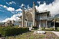
- Vorontsov Palace
- Bakhchisaray Palace
- Nikitsky Botanical Garden
- Naval museum complex Balaklava
- The Valley of Ghosts
Economic Sanctions
After Russia's actions in Crimea in 2014, many countries put economic sanctions on Russia and Crimea. These sanctions stop the sale of certain goods and technology. They also affect tourism and infrastructure. Some sanctions include travel bans and freezing assets for individuals. Major credit card companies like Visa and MasterCard temporarily stopped services in Crimea in 2014.
Crimea's People

As of 2014, the total population of Crimea was about 2,248,400 people. This is a bit lower than in 2001.
According to a 2014 Russian census, 84% of Crimeans said Russian was their native language. Crimean Tatar was spoken by 7.9%, and Ukrainian by 3.3%. In 2001, 77% spoke Russian, 11.4% spoke Crimean Tatar, and 10.1% spoke Ukrainian.
The number of different ethnic groups in Crimea has changed a lot since the early 1900s.
| Date | 1785 | 1795 | 1816 | 1835 | 1850 | 1864 | 1897 | 1926 | 1939 | 1959 | 1970 | 1979 | 1989 | 2001 | 2014 | |||||||||
|---|---|---|---|---|---|---|---|---|---|---|---|---|---|---|---|---|---|---|---|---|---|---|---|---|
| Carried out by | Russian Empire | Soviet Union | Ukraine | Russia | ||||||||||||||||||||
| Ethnic group | % | % | % | % | % | % | Number | % | Number | % | Number | % | Number | % | Number | % | Number | % | Number | % | Number | % | ||
| Russians | 2.2% | 4.3% | 4.8% | 4.4% | 6.6% | 28.5% | 180,963 | 33.11% | 301,398 | 42.2% | 558,481 | 49.6% | 858,273 | 71.4% | 1,220,484 | 67.3% | 1,460,980 | 66.9% | 1,629,542 | 67.0% | 1,450,400 | 60.4% | 1,492,078 | 67.9% |
| Ukrainians | 1.3% | 3.6% | 3.1% | 7% | 64,703 | 11.84% | 77,405 | 10.6% | 154,123 | 13.7% | 267,659 | 22.3% | 480,733 | 26.5% | 547,336 | 25.1% | 625,919 | 25.8% | 576,600 | 24.0% | 344,515 | 15.7% | ||
| Crimean Tatars | 84.1% | 87.6% | 85.9% | 83.5% | 77.8% | 50.3% | 194,294 | 35.55% | 179,094 | 25.1% | 218,879 | 19.4% | 5,422 | 0.2% | 38,365 | 1.6% | 245,200 | 10.2% | 232,340 | 10.6% | ||||
| Belarusians | 2,058 | 0.38% | 3,842 | 0.5% | 6,726 | 0.6% | 21,672 | 1.8% | 39,793 | 2.2% | 45,000 (e) | 2.1% | 50,045 | 2.1% | 35,000 | 1.5% | 21,694 | 1.0% | ||||||
| Armenians | .6% | 1.3% | 1.5% | 1% | 6.5% | 8,317 | 1.52% | 10,713 | 1.5% | 12,923 | 1.1% | 3,091 | 0.2% | 2,794 | 0.1% | 10,000 | 0.4% | 11,030 | 0.5% | |||||
| Jews | 2.3% | 2.3% | 2% | 2.2% | 7% | 24,168 | 4.42% | 45,926 | 6.4% | 65,452 | 5.8% | 26,374 | 2.2% | 25,614 | 1.4% | 17,371 | 0.7% | 5,500 | 0.2% | 3,374 | 0.1% | |||
| Others | 13.7% | 3.9% | 2.1% | 5.5% | 5.4% | 7.7% | 72,089 | 13.19% | c.27,500 | 2.3% | 92,533 | 4.2% | ||||||||||||
| Total population stating nationality | 546,592 | 713,823 | 1,126,429 | 1,813,502 | 2,184,000 | 2,430,495 | 2,401,200 | 2,197,564 | ||||||||||||||||
| Nationality not stated | 12,000 | 87,205 | ||||||||||||||||||||||
| Total population | 1,201,517 | 2,458,600 | 2,413,200 | 2,284,769 | ||||||||||||||||||||
Crimean Tatars are a group that mostly follows Islam. In 2001, they made up 12.1% of the population. They formed in Crimea in the early modern era. During World War II, Joseph Stalin's government forced them to move to Central Asia. After the Soviet Union ended, many Crimean Tatars began to return.
Historically, there were also Krymchaks and Karaites (Jewish groups) in Crimea. The Krymchaks were targeted during the Nazi occupation.
In 1939, there were 60,000 Germans in Crimea. During WWII, Stalin also forced them to move. In 1944, Stalin also deported 70,000 Greeks, 14,000 Bulgarians, and 3,000 Italians.
Life Expectancy
-
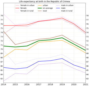
Life expectancy in the Republic of Crimea
-
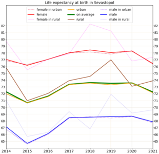
Life expectancy in Sevastopol
-
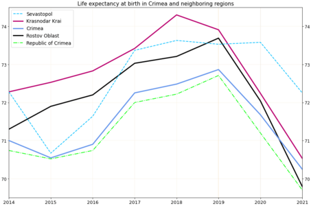
Life expectancy in Crimea and neighboring regions


Religion in Crimea
Religion in Crimea (2013) Orthodox Christians (58%) Muslims (15%) Belief without religion (10%) Atheists (2%) Other religion (2%) Not stated (13%)
In 2013, 58% of Crimeans were Orthodox Christians. Muslims made up 15% of the population.
Crimean Culture

Many famous artists and writers have been inspired by Crimea. Alexander Pushkin visited Bakhchysarai in 1820 and wrote a poem about it. Adam Mickiewicz wrote "The Crimean Sonnets" after his trip in 1825. These poems describe Crimea's nature and culture.
Ivan Aivazovsky, a famous marine painter from the 19th century, was born in Feodosia. Many of his paintings show the Black Sea. He also painted battle scenes during the Crimean War.

Crimean Tatar singer Jamala won the Eurovision Song Contest 2016. Her song "1944" was about the forced movement of Crimean Tatars in that year.
-
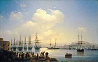
Painting of the Russian squadron in Sevastopol by Ivan Aivazovsky (1846).
-
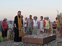
The grave of Russian poet and artist Maximilian Voloshin.
-
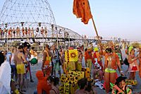
People at the Kazantip music festival in 2007.


Sports in Crimea
After Crimea's vote to join Russia in 2014, top football clubs left the Ukrainian leagues. UEFA (Union of European Football Associations) decided that Crimean clubs could not join Russian leagues. Instead, they should be part of a special Crimean league. The Crimean Premier League is now the main professional football league in Crimea.
Some athletes born in Crimea have been allowed to compete for Russia. This includes Vera Rebrik, a European javelin champion.
Images for kids
-

Bakhchisaray Palace
-

Dulber Palace in Koreiz
-
Vorontsov Palace
-

Livadia Palace
-

Catholic church in Yalta
-

St. Vladimir's Cathedral, dedicated to the Heroes of Sevastopol (Crimean War).


See also
 In Spanish: Crimea para niños
- 2014 Russian military intervention in Ukraine
- List of cities in Crimea
- Politics of Crimea
