
Culiacán facts for kids
Quick facts for kids
Culiacán Rosales
|
||
|---|---|---|
|
||
| Nickname(s):
La Perla del Humaya
(The Pearl of the Humaya) |
||

Culiacán
Location in Sinaloa

Culiacán
Location in Mexico
|
||
| Country | Mexico | |
| State | Sinaloa | |
| Municipality | Culiacán (seat) | |
| Foundation | 1531 | |
| Area | ||
| • City | 65 km2 (25 sq mi) | |
| Elevation | 71 m (233 ft) | |
| Population
(2020)
|
||
| • Urban | 808,416 | |
| • Metro | 1,003,530 | |
| • Demonym | Culiacanense / "culichi" | |
| GDP (PPP, constant 2015 values) | ||
| • Year | 2023 | |
| • Total (Metro area) | $17.8 billion | |
| • Per capita | $20,000 | |
| Time zone | UTC−7 (MST) | |
| Waterways | Tamazula River, Humaya River, Culiacán River | |
| Airports | Federal de Bachigualato International Airport | |
| Public transit | RedPlus | |
| Railroads | Ferromex Culiacán Station | |

Culiacán, officially known as Culiacán Rosales, is a large city in northwestern Mexico. It is the capital and biggest city of both the Culiacán Municipality and the state of Sinaloa. Spanish explorers Lázaro de Cebreros and Nuño Beltrán de Guzmán founded the city on September 29, 1531. They named it "Villa de San Miguel" after its patron saint, Michael the Archangel.
In 2020, Culiacán had about 808,416 people living there. This makes it the 21st most populated city in Mexico. Its wider metropolitan area had a population of 1,003,530, making it the 17th largest in Mexico. The city is in a valley, nestled on the slopes of the Sierra Madre Occidental mountains. It sits where the Tamazula and Humaya rivers meet, forming the Culiacán River.
Contents
- What Does the Name Culiacán Mean?
- Culiacán's Past: A Look at Its History
- Culiacán's Official Symbol: The Coat of Arms
- Culiacán's Location and Natural Features
- People and City Life in Culiacán
- Fun Places: Parks and Green Areas
- Culiacán's Economy
- Getting Around Culiacán: Transportation
- Fun and Entertainment in Culiacán
- Famous People from Culiacán
- Images for kids
- See also
What Does the Name Culiacán Mean?
The original name of Culiacán comes from the Aztecs and their Nahuatl language. It was called Colhuacán or Culhuacán. The meaning of this name can change depending on who you ask.
Some ideas for its meaning include:
- "Snake place"
- "Crooked hill"
- "Where walkers twist the path"
The most accepted idea is "place of the colhuas," meaning "inhabited by the Colhua tribe." Another common meaning is "place of worshiping the god Coltzin."
Culiacán's Past: A Look at Its History
Ancient Times: Before the Spanish Arrived
Long ago, there was an old settlement called Huey Colhuacan. It was built by the Aztecs around 628 CE during their long journey. We don't know its exact spot today, but it was likely near the modern town of Culiacáncito. The people who lived there were known as Culichis.
How Culiacán Was Founded
The city we know today was started in 1531 by the Spanish conquistadors Lázaro de Cebreros and Nuño Beltrán de Guzmán. They called it "Villa de San Miguel." When the Spanish arrived in the 1500s, they found many small villages. These villages were organized into groups by the Tahues tribe. Other native groups living in the area were the Tebacas, Pacaxes, Sabaibo, and Achires.
After their battles, de Cebreros and de Guzmán divided the land into three areas in 1531. One of these was Culiacán. It stretched from the Elota River in the south to the Mocorito River in the north. This area was part of the Kingdom of Nueva Galicia. This setup lasted until 1786.
Culiacán in Independent Mexico
On October 6, 1821, Culiacán declared its independence from Spain. This was part of the Mexican War of Independence. Culiacán officially became a city on July 21, 1823. This happened when the areas of Sonora and Sinaloa separated. In 1824, Sinaloa and Sonora joined again, forming the state of the West.
However, on October 13, 1830, Sonora and Sinaloa separated for good. Culiacán was then chosen as the capital of the state of Sinaloa. From 1859 to 1873, the capital moved to Mazatlán. But Governor Eustaquio Buelna brought it back to Culiacán. The local government then made Culiacán the state capital again.
Culiacán in the Early 1900s
In 1878, Culiacán had three main local governments. These were in Culiacán, Quilá, and Badiraguato. This changed in 1880 when Badiraguato became its own district again.
In 1912, a new law created municipalities as a way to govern local areas. This law officially started in 1915. Culiacán became a municipality on April 8, 1915. The area of Navolato was originally part of Culiacán. But it became its own municipality on August 27, 1982. This meant Culiacán lost a large area of farmland.
_(cropped).jpg)
Later, the state government added "de Rosales" to the city's name. This was to honor Antonio Rosales. He was a brave Mexican military leader and a former governor of Sinaloa.
Culiacán's Official Symbol: The Coat of Arms

The coat of arms for Culiacán shows important parts of its past and present. Rolando Arjona Amábilis designed this official symbol. It was made official on May 26, 1960.
The shield is square with rounded corners and a point at the bottom. It is colored a deep red. In the middle, there is a symbol of a hill with a human head. This symbol represents Coltzin, an ancient god from Nahuatl stories. Coltzin gave his name to the Colhua tribe and their town, Colhuacán.
Across the shield, there are wavy lines that stand for rivers. On the left side, a cross and footprints show the path missionaries took from San Miguel de Culiacán to the north. This honors their good deeds and bravery.
The word "Culiacán" is written at the top of the red border. At the bottom, you can read "Colhuacán," which is the city's original name in the Nahuatl language. At the very top of the shield, there is a hill with a sprouting seed and a golden sun. This represents the warm climate and the hard work of the farmers in the area.
Culiacán's Location and Natural Features
Where is Culiacán?
Culiacán is in the middle of the State of Sinaloa, in northwestern Mexico. Its exact location is 24° 48'15" North and 107° 25'52" West. The city is about 54 meters (177 feet) above sea level.
Culiacán is about 1,240 kilometers (770 miles) from Mexico City. It's also 502 km (312 mi) from Tepic and 536 km (333 mi) from Durango.
Mountains and Rivers
The area around Culiacán has two main types of land: mountains and flat coastal plains. The mountains are part of the Sierra Madre Occidental range. They reach heights of 300 to 2,100 meters (984 to 6,890 feet).
The flat coastal plain is to the west. Four main rivers flow through this area: the Humaya, Tamazula, Culiacán, and San Lorenzo. The Humaya River starts in the State of Durango. Its waters are controlled by the Licenciado Adolfo López Mateos dam. The Tamazula River also starts in the Sierra Madre Occidental. Its waters are controlled by the Sanalona dam.
The Humaya and Tamazula rivers meet right in front of Culiacán. They form the Culiacán River, which then flows into the Gulf of California. The San Lorenzo River also begins in the Sierra Madre Occidental and flows into the Gulf of California.
Culiacán's Weather

Culiacán has a hot, semi-arid climate. This means it's usually hot and dry, even though it gets over 600 millimeters (24 inches) of rain each year. This is because of its high temperatures and a lot of evaporation.
Summers are very hot and humid. Temperatures can reach 45°C (113°F) in the shade. The high humidity can make it feel even hotter, sometimes like 50°C to 55°C (122°F to 131°F). There's also a chance of heavy rain from tropical storms. Winters are much milder, with less humidity. The average high temperature is around 27°C (81°F), and nights are warm.
People and City Life in Culiacán
How Many People Live Here?
.jpg)
The Culiacán Municipality has about 858,638 people, according to the 2010 census. This means about 31% of Sinaloa's total population lives here. There are slightly more women than men.
The city of Culiacán Rosales itself had 675,773 people in 2010. This makes it the largest urban area in Sinaloa. Most of the municipality's population lives in the city.
A small number of people in Culiacán speak indigenous languages, about 13,081 people. Most of these groups are not originally from Culiacán. They moved here from other places.
Culiacán also has people from other countries. About 6,693 foreign residents live here, which is almost 1% of the total population. Many come from the United States, Canada, Spain, Italy, and Greece. There's a notable Greek community in Culiacán. Many Greeks came in the 1940s and 1950s to work in farming. They found it profitable and encouraged family and friends to join them.
Homes and Buildings
There are 221,144 homes in Culiacán. About 176,799 of these are lived in, with an average of 3.81 people per home. Most homes are built with cement roofs, walls, and floors. However, some older or poorer homes, especially on the city's edges, might have sheet roofs and dirt floors.
Most homes have electricity, running water, and drainage. The city has many tall buildings. Some of the most famous are Torre Tres Ríos, Torre Santa María, and Torre Tres Afluencias. These are in the Tres Ríos Urban Development, an important area of the city.

How the City is Divided
Culiacán is split into different areas:
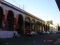
- The Historical Center of Culiacán is the oldest part of the city. It has many buildings from the 16th to 19th centuries. For a while, fewer people lived here because of high rents and busy streets. But now, more apartments are being built, and the city is working to bring more people back.

- Las Colonias are the first neighborhoods that grew around the old city center. People from different backgrounds moved here to be close to downtown. Some well-known ones include Infonavit Humaya, Tierra Blanca, and Miguel Alemán.
- Subdivisions are planned areas built by construction companies. Homes in these areas often look similar. They are for people in the lower-middle, middle, and upper-middle classes. Examples are La Conquista and Villas del Rio.
.jpg)
- Residentials are special areas built for people with more money. They have large houses, big green spaces, and are often private. Some famous ones are Tres Ríos, Chapultepec, and Isla Musalá.
- Tres Ríos Urban Development is a very large and important area. It started in 1990 to create better places for shopping, living, and fun. It also uses the land near the Culiacán, Humaya, and Tamazula rivers, making the riverbanks beautiful with plants and a new walkway.
Fun Places: Parks and Green Areas
Culiacán has many green spaces. The city government works to protect and increase these areas. They help make life better for everyone in Culiacán and for visitors.
Las Riberas Park

This park is next to the Tamazula and Humaya rivers. You can see many types of trees here, like willows and eucalyptus. The White Bimodal bridge connects the park to the city center. At night, the bridge lights up, creating a beautiful view.
Culiacán Botanical Garden
.jpg)
Located on the east side of the city, this garden covers 10 hectares (about 25 acres). It has many different ecosystems and hundreds of plant and tree species. There's also an art display called "Encounter" by James Turrel. The garden is home to over 2,000 different plants.
Orabá Island
Orabá Island is an island where the Tamazula River and the Humaya River meet, forming the Culiacán River. It's part of a group of parks and gardens built along the rivers.
Culiacán Zoo
The Culiacán Zoo is in the heart of the city, covering 13.5 hectares (about 33 acres). It has 1,400 animals from over 450 species, including mammals, reptiles, and birds. The zoo was built on December 14, 1950. It was created to help teach people about the plants and animals in the region.
Tres Ríos Water Park
This park is a fun place built where the Humaya and Tamazula rivers meet, right where the Culiacán River begins. It's very close to Las Riberas Park. It is one of the largest and most visited parks in the northwest of Mexico.
Dancing Fountains
The dancing fountains of Culiacán are a special show. Hundreds of fountains are programmed to "dance" to Sinaloan music. This show happens every day in the Tres Ríos Project area, near where the Humaya and Tamazula rivers join.
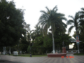
Obregón Square

This square is located on Álvaro Obregón Avenue.
Culiacán's Economy
Culiacán's economy is mostly based on farming and trade. It's a big center for selling produce, meat, and fish. Overall, Culiacán contributes about 32 percent to the state's economy.
Many important Mexican companies have their main offices in Culiacán. These include Coppel, Casa Ley, and Homex.
Getting Around Culiacán: Transportation
Bus and Train Travel
The main bus station in Culiacán is the "Millennium" International Buses Station. From here, you can travel across Mexico and to parts of the United States like Arizona and California.
The city also has a train station, run by Ferromex. This station is used only for moving goods, not people. It connects Culiacán to Mazatlán in the south and Guaymas in the north.
City Roads and Bridges
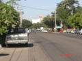
Culiacán has many roads, but some are narrow. This means traffic jams are common during busy times. There are about 300,000 cars in Culiacán.
The city has 13 bridges. Six cross the Tamazula River, two cross the Humaya River, and the longest one, along with four others, crosses the Culiacán River. Even with these bridges, traffic can still be heavy.
Some of the main roads include:
- Álvaro Obregón Ave
- Francisco I. Madero Blvd.
- Paseo Niños Heroes
- El Dorado Ave
- Aeropuerto
- Emiliano Zapata Blvd.
- Benjamín Hill Ave
- Calzada de las Torres
- México 68
- Plan Mar de Cortes
- Heroico Colegio Militar
- Revolución Ave
- Sanalona Way
- Rolando Arjona Amabilis Blvd.
- Universitarios
- José Limón Blvd.
- Las Américas
- Diego Valadez Ríos
- Manuel J. Clouthier
- Miguel Hidalgo y Costilla
- José Vasconcelos
- Gabriel Leyva Solano Blvd.
- Xicoténcatl
- Josefa Ortíz de Domínguez
- Enrique Sanchez Alonso Blvd.
- De los Insurgentes
- Pedro Infante Blvd.
- Rotarismo Road
- Ciudades Hermanas
- Patria Ave
- Constituyentes Emiliano García
- Nicolás Bravo
- 21 de Marzo Ave
- Las Minas
Highways and Freeways
Culiacán is on the Panamerican Highway. This highway goes north to the United States and south to Guadalajara and Mexico City. There's also the Benito Juárez Highway, a toll road that runs next to the free federal highway. It connects Culiacán to Los Mochis in the north and Mazatlán, Tepic, and Guadalajara in the south.
Some key highways are:
- Mexican Federal Highway 15 (north: Los Mochis, south: Mazatlán)
- Sanalona Free Highway (southeast: Sanalona/Cosalá)
Culiacán is also connected to the nearby city of Navolato by a freeway. This freeway now reaches Altata on the Pacific Ocean coast. Culiacán is also linked to Tamazula de Victoria in Durango state.
Culiacán's Airport
Culiacán is served by the Federal de Bachigualato International Airport (CUL/MMCL). This is the most important airport in Sinaloa for flights within Mexico. It's also the second busiest for international flights after Mazatlán International Airport. The airport is located south of downtown Culiacán.
Fun and Entertainment in Culiacán
Places to Visit

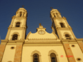
- Culiacán Cathedral is a beautiful church that started being built in the 1830s.
- Plazuela Alvaro Obregón was a popular spot for people to gather in the 1800s.
- La Lomita or Templo de Nuestra Señora de Guadalupe is the tallest church in Culiacán. It sits on a hill and offers a great view of the whole city.
- The Regional History Museum in "Parque Constitución" is a large art museum downtown. There are also smaller art galleries run by local universities.
- The Botanical Garden and Centro de Ciencias de Sinaloa (a science museum) are great places to learn. The science museum has the fifth-largest meteorite on Earth!
- For sports fans, there's the Estadio Angel Flores, home to the Los Tomateros de Culiacán baseball team. The Estadio Banorte (formerly Estadio Carlos González) is where the Los Dorados de Sinaloa football team plays.
- Culiacán also has a unique and delicious food scene.
- There are many interesting places to visit near the city too.
Sports in Culiacán
Culiacán is home to three professional sports teams:
- Baseball: The Tomateros de Culiacán play in the Liga Mexicana del Pacífico. They have won two championships in the Caribbean Series (in 1996 and 2002).
- Football (Soccer): The Dorados de Sinaloa play at the Estadio Banorte.
- Basketball: The Caballeros de Culiacán play in the CIBACOPA league.
If you enjoy hunting, duck, dove, and goose hunting season runs from early November to March. Culiacán also hosts an international marathon every year.
Famous People from Culiacán
Science
- Carmen Victoria Félix Chaidez
Entertainment
- Yolanda Andrade, TV host
- Ariel Camacho, singer
- Luis Campos, drummer
- Cesar Millan, dog trainer
- Paul Rodriguez, Hollywood actor
- Chalino Sánchez, Mexican singer
- Sheyla Tadeo, actress and comedian
Sports
- Irene Aldana (born 1988), mixed martial artist
- Julio César Chávez, famous boxer with six world championships
- Julio César Chávez, Jr., former boxing champion
- Omar Chávez, boxer
- Óliver Pérez, Major League Baseball player
- Alberto Medina, footballer
- Jared Borgetti, footballer
- Jorge Iván Estrada, footballer
- Héctor Moreno, footballer
- Gilberto Villarreal Solis, baseball player
- Julio Urías, Major League Baseball player, World Series champion
- Joey Meneses, Major League Baseball
- Ozziel Herrera, footballer
Modeling
- Paulina Flores Arias, Miss Mexico 2000
- Rosa María Ojeda, Miss Mexico 2006
- Laura Elena Zuniga Huizar, Miss Mexico 2008
- Perla Judith Beltrán Acosta, Miss Mexico 2009
Images for kids
-
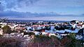
Panoramic view of Culiacán
-

Culiacán Botanical Garden
-
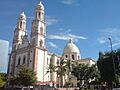
Culiacán Cathedral
-
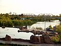
Tres Ríos District
-
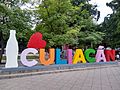
Culiacán letters
-

Tomateros de Culiacán ball monument
-

Sunset at Culiacán
-
Culiacán Cathedral
-
Culiacán's downtown
-
Culiacán street
-
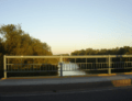
Culiacán River by Sinaloa Blvd
-
"La Plazuela Rosales"
-
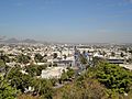
View north of Avenida Prol. Alvaro Obregon from Mirador La Lomita


See also
 In Spanish: Culiacán para niños
