Derrick Cave facts for kids
Quick facts for kids Derrick Cave |
|
|---|---|

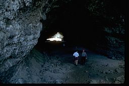
Visitors walking through Derrick Cave
|
|
| Location | Northern Lake County, Oregon, United States |
| Depth | 53 feet (16 m) |
| Length | 1,134 feet (346 m) |
| Geology | Lava tube |
| Difficulty | Moderate |
| Access | Public |
Derrick Cave is an amazing lava tube cave located in a quiet part of Lake County, Oregon. It's about 1,200 feet (370 m) long. In some spots, it's as wide as 80 feet (24 m) and 46 feet (14 m) high! The cave is named after H.E. Derrick, a rancher who lived about 3 miles (4.8 km) away. The land around the cave is looked after by the Bureau of Land Management. You can visit Derrick Cave all year. But camping inside the cave is not allowed anymore.
Contents
How Was Derrick Cave Formed?
Derrick Cave is a classic example of a lava tube. It was made by hot lava flowing downhill from a volcanic vent (a crack where lava comes out) north of the cave. This lava also created an area called Devils Garden. This is a 45 square miles (120 km2) bed of lava southwest of the cave. Most of the lava that made Devils Garden came through the Derrick Cave lava tube.
The cave started as an open river of lava flowing south. Over time, the top of this lava river cooled and hardened. This formed a roof, creating a tunnel or tube. When the volcano stopped erupting, the lava drained out of the tube. This left behind the empty space we now call Derrick Cave. After the cave cooled, parts of its roof fell in. These collapsed spots became the entrances to the north and south parts of the cave.
Scientists aren't exactly sure how old the eruption was that made Derrick Cave. But they know it's not older than 13,000 years. It's also not younger than 6,845 years. This is known because of ash from Mount Mazama that covers the area.
What's the History of Derrick Cave?
The cave got its name from H. E. Derrick, a pioneer rancher. He lived about 3 miles (4.8 km) southeast of the cave. Because it was big and cool, early settlers in the Fort Rock area often used the cave. It was a great place for summer fun! During parties at the cave, families would use the ice found inside to make ice cream.
During the early days of World War II, people living nearby thought about using Derrick Cave as an air-raid shelter. This was in case Japan started bombing the west coast of the United States. People in Central Oregon never needed an air raid shelter during World War II. But in 1963, Derrick Cave was chosen as a nuclear fallout shelter. This meant it was a safe place during emergencies. Food and water for up to 1,200 people were stored there. These supplies were kept in a small part of the cave behind a locked steel door. However, people broke in several times and took the food. They left the water cans, probably because they were frozen solid. By 1970, all the supplies were either taken or removed by authorities.
The National Aeronautic and Space Administration also used Derrick Cave in the 1960s. They were planning lunar landings and wanted to know if caves could be found from high up using special tools. To help NASA, other companies did tests using Derrick Cave as their underground target.
In 1994, the Bureau of Land Management made new rules for Derrick Cave. These rules stopped camping, campfires, and cigarette smoking inside the cave. Large group gatherings were also discouraged. These activities made the cave warmer, which bothered bats and tiny living things. Climbing with bolts was also not allowed. Signs with these rules were put up near the cave entrance.
What Animals Live Around Derrick Cave?
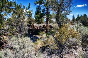
The area near the cave entrance has many Western juniper and Ponderosa pine trees. You'll also see big sagebrush, bitterbrush, mountain mahogany, and different desert grasses. Common grasses include Idaho fescue and bluebunch wheatgrass.
Many animals live in the forest around the cave. These include mule deer, pronghorn, coyotes, bobcats, cougars, and American black bears. Smaller animals like American badgers, porcupines, and chipmunks are also common. There are many types of birds too! You might see mountain bluebirds, western meadowlarks, white-crowned sparrows, and sage grouse. Larger birds include ravens, great horned owls, turkey vultures, red-tailed hawks, golden eagles, and bald eagles.
Inside the cave, water from rain and melting snow seeps through the ground. It collects as ice during winter. Dripping water often forms ice stalagmites that can be 3 feet (0.91 m) tall. This ice usually melts in the summer. But sometimes, it can last through an entire year!
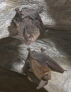
Derrick Cave is home to Townsend's big-eared bats. These bats hibernate (sleep deeply) from October until late April. They are nocturnal, meaning they are active at night and sleep during the day. If you see a bat, the Oregon Department of Fish and Wildlife says it's best not to disturb it. This is super important when bats are hibernating. Waking a bat from hibernation can be very stressful for them. It can even cause them to die because they use up too much energy.
Exploring Derrick Cave
Derrick Cave is open all year. The cave entrance is 4,960 feet (1,510 m) above sea level. The cave itself is between 14.5 feet (4.4 m) and 53 feet (16 m) below the ground. The total length of the cave is 1,134 feet (346 m). The Bureau of Land Management says the cave is moderately difficult to explore.
The entrance to Derrick Cave looks like a big broken hole in the ground. From there, you enter a wide lava tube. The tube goes in two directions: north and south. The north part of the cave is quite small. This is where the emergency shelter used to be. The south part of the cave goes gently downhill. The floor in this area is covered with volcanic sand. Over many years, parts of the ceiling have fallen in. This created natural skylights and piles of rock below. In this area, the cave is about 30 feet (9.1 m) wide.
After the last skylight, the cave gets dark. You will need a light to go further. After a short walk, the cave opens into a huge room. It's 80 feet (24 m) wide with a ceiling that reaches 46 feet (14 m) high! This area is called the Big Room. In the Big Room and beyond, you can see the original lava flow lines on the walls. They look like rounded shelves and marks etched into the walls. In some places, there are also 5-inch (13 cm) lavacicles hanging from the ceiling. These formed after the lava drained out. Hot gases trapped in the tube melted the walls, causing drips to form. As the gas cooled, these drips hardened into lavacicles.
Tips for Visiting
Derrick Cave is located at the northeast corner of Devils Garden. It's about 22 miles (35 km) northeast of a small community called Fort Rock, Oregon. The land around the cave is managed by the Bureau of Land Management. The road to Derrick Cave is very rough, and there are no facilities (like restrooms or water) at the site. The Bureau of Land Management suggests planning your trip carefully and being careful on the road.
Visitors should wear warm clothes because the cave is quite cool. Battery-powered lights are best, as long as they give good light.
Today, the Bureau of Land Management has rules to protect caves on government land. The rules for Derrick Cave and other caves in Oregon and Washington say you cannot do the following things in or near natural caves:
- Deface, remove, or destroy plants, soil, rocks, minerals, or other cave features.
- Dig, excavate, or move any natural or cultural features.
- Camp.
- Build campfires, use stoves, or smoke.
- Leave human waste in or near a cave.
- Shoot a firearm, air rifle, or paint gun.
- Have or set off fireworks or other pyrotechnics.
- Bring a pet into a cave.
- Do anything that disturbs the environment within 350 feet (110 m) of a cave opening or any known cave passages.
 | Valerie Thomas |
 | Frederick McKinley Jones |
 | George Edward Alcorn Jr. |
 | Thomas Mensah |


