
Dunlop, East Ayrshire facts for kids
Dunlop (pronounced dun-LOP) is a village and parish located in East Ayrshire, Scotland. It sits on the A735 road, northeast of Stewarton and about 7 miles (11 km) from Kilmarnock. Other roads connect it to Lugton, Beith, and Burnhouse.
Quick facts for kids Dunlop
|
|
|---|---|
 Main Street, Dunlop |
|

Dunlop
|
|
| Population | 1,170 (2020) |
| Council area | |
| Lieutenancy area |
|
| Country | Scotland |
| Sovereign state | United Kingdom |
| Post town | Kilmarnock |
| Postcode district | KA3 |
| Dialling code | 01560 |
| Police | Strathclyde |
| Fire | Strathclyde |
| Ambulance | Scottish |
| EU Parliament | Scotland |
| UK Parliament |
|
| Scottish Parliament |
|
Contents
History of Dunlop
The Village's Story
The name Dunlop was first written down in 1260. It might come from old Gaelic words: Dun meaning "a castle" and Luib meaning "a bend". So, it could mean "the castle on the hill by the river bend". People used to say "Dulop" or "Delap" without the 'n', which makes some think it has other origins.
In the 1600s, Dunlop held two yearly fairs to sell dairy animals. One was in May, and the other, called Hallowday, was in November. The area became known as the Barony of Dunlop in 1688. Over time, the name has been spelled in many ways, like Dunlap, Dunlopp, and Dulop.

Dunlop cheese, a sweet milk cheese, was first made by Barbara Gilmour. She went to Ireland to escape religious problems. Her old stone cheese press was said to be kept at 'The Hill' Farm. This cheese became famous worldwide and helped many local families earn money. Cheese sellers from Kirktoun would buy the cheeses and take them to Glasgow to sell. Making cheese used up extra fresh milk. However, when railways arrived, farmers could send fresh milk directly to Glasgow, so less cheese was made. Today, Dunlop cheeses are still made at Clerkland Farm.
A local legend tells of Tam Giffen, a supposed warlock (a male witch) from Dunlop Parish in the 1860s. Many stories are told about his amazing deeds. For example, when the Lugton Water river was flooded, Tam supposedly "came through below it" instead of crossing over. Another time, he tried to help the Devil blow a man off a roof but could only blow off his wig and hat because the man said "God save me". Tam was said to have died mysteriously, possibly killed by fairies for sharing their secrets.
In 1791, Dunlop had many skilled workers: six masons (builders), 12 weavers, three blacksmiths, three shoemakers, four tailors, and three inn-keepers. By 1874, the village had even more shoemakers (10), masons (8), and blacksmiths (6), but no baker or butcher. The people were so healthy that no doctor or lawyer was needed!
In 1823, 'Mackie's Mill' started making wool blankets on the banks of the Glazert Water. By 1939, it was making carpet yarn and had opened two more factories. In 1849, Mr. Wilson started a business curing ham. By the 1930s, this business had grown, with factories in Barrhead and Eglinton in Irvine. The original curing house, called the 'Burnhouse', has now been turned into a local park. Robert Howie and sons started a small meal-mill in 1857, then a sawmill. They later moved closer to the railway.
The railway arrived in Dunlop in 1871. This improved connection to Glasgow meant farmers could send their milk directly to the city, which led to the end of cheese making in Dunlop. The village population was 380 in 1871 and 357 in 1881. By 1876, the town had a butcher, a baker, a bank, and a church, but still no lawyer or doctor was needed. By the 1950s, Dunlop had a post office, four grocery stores, a bakery, a newsagent, a hotel, and a pub.
Below the church is a bridge over the Black Burn, known locally as the 'Tee Wal Burn'. This name comes from a spring that flows out under the bridge. People often thought the 'Tea Well' water was so pure they used it for their tea.
Dunlop's Old Castles

Local stories say that the De Ross family first lived at Boarland or Dunlop hill (NS 4019 4940), where a strong castle once stood. Later, they moved to Corsehill in Stewarton. There might have been an ancient Celtic hillfort here, which fits with the meaning of the place name.

In 1848, a journal noted that "the foundation of a ruin of considerable extent was removed" many years before. In 1853, Mr. Dobie wrote that you could still see the outlines of a large building on top of the Hill of Borland. In 1856, Mr. G. Howie remembered seeing a small part of what was said to be one of the walls. Since then, the ruins have been removed, and the land is now farmed. On the south side of the hill, there are remains of a wide ditch, known as the 'Cuckoo slide'.
Pont, an old mapmaker, said that the ancient strong Dunlop Castle by the Clerkland Burn (NS 42737 49312) was protected by a moat (a water-filled ditch) and had "goodly" orchards. It was also called Hunt Hall because the Dunlop family were huntsmen for the De Ross family. The whole estate was sometimes called Hunt Hall. This castle was located where the current Dunlop House stands.
The De Ross family were loyal to the De Morvilles, who were the main lords of Cunninghame. The De Morvilles supported John Balliol's claim to the crown and lost their lands to the Boyds. By 1570, the Cassillis family held the lands. In 1600, David Dunlop of Hapland traded his lands with Patrick Cunninghame for his part of the Borland lands.
The native chiefs, even after moving from Boarland Hill, stayed in the area and built what is now Dunlop House. The name Boarland still exists in names like Borlandhill and Over Borland. 'Boarland' could mean there were wild boars, but a 'Boor' also meant a servant. Norman lords often gave land near their castles to their servants. 'Bordland' also meant land used to provide food for the lord's castle.
Dunlop Hill was used by the military in the 20th century. Between World War I and World War II, a Royal Observer Corps post (a lookout station) was built on top of the hill. People there tracked enemy aircraft flying up the Clyde towards Glasgow. After World War II, better radar tracking made the post unnecessary. Until the 1970s, a bunker was operated on the hilltop. Its entrance and vents can still be seen.
The Dunlop Family

The first Dunlop mentioned in records is William de Dunlop in 1260. Later, Neil Fitz-Robert de Dulap supported Edward I in 1306. He lost his lands for supporting John Balliol. However, the family got their lands back by the mid-1400s. By then, they were known as "Dunlop of that Ilk," meaning "Dunlop of Dunlop."
Sir James Dunlop of that Ilk owned the estate in 1596. He married Jean, daughter of Somerville of Cambusnethan. This might explain why the Somerville family later bought lands nearby to create the Kennox Estate.
Francis Dunlop was a witness when the Scottish Crown Jewels were officially recorded in Edinburgh Castle after Scotland and England joined under one king. James Dunlop (1634-1670) married Elizabeth, daughter of Cunninghame of Corsehill. He was an important leader of the covenanters, who were Scottish Presbyterians who supported their religion against the king.
John Dunlop (1748-1784) married the daughter of Sir Thomas Wallace of Craigie. She was a supporter of the famous poet Robert Burns. John Dunlop Esq. MP lived at Dunlop House in 1837. It was described as one of Ayrshire's most beautiful mansions. The house was designed in 1831–34 by David Hamilton for Sir James Dunlop of Dunlop. It has an unusual Scottish-Jacobean style. The last Baronet (a type of noble title) was Major Sir James Dunlop (1839-1858), who died without marrying.
The last Dunlops born at Dunlop House were John (1904) and Alexander (1906) Houison Crawfurd. Mrs. Houison Crawfurd was known for having the first tuberculosis-free cattle in Ayrshire. The house was rented to several families, including the Henderson family, who owned the Anchor Line shipping company. In 1933, the house was sold to Ayrshire County Council to be a home for children with learning disabilities (using the language of that time).
The Clerkland Burn stream flows past Dunlop House, marking the boundary between the parishes of Stewarton and Dunlop.
The Brechna Braes and Brackenheugh
The Brechna Braes area is near Dunlop and has been turned into the Templehouse Community Woodland to celebrate the year 2000. The Brackenheugh is a wooded slope overlooking Aiket Castle. It is said to be where a Cunninghame of Aiket was killed by a Montgomerie during the old family feuds.
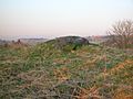
-
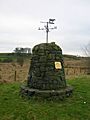
The cairn at the Dunlop Millennium Community Woodland
-
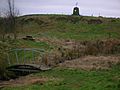
A view of Braikenheugh Hill, the bridge, etc.
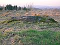
-
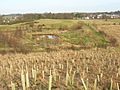
The view from the Templehouse woodland
-
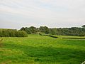
The Brackenheugh from Aiket Castle


Dunlop Church
In 1516, John Major, who taught John Knox, was the vicar (a type of priest) of Dunlop Church, though he was often away as he was a theology professor. By 1566, John Houston was the vicar. The lands of Kirkland-Dunlop then went from the Abbots of Kilwinning to William Cunninghame of Aiket. The Earl of Eglinton held the right to choose the minister until this system ended in 1875.


The church (NS 40474 49414) was likely built around 1766. However, by 1834, it was falling apart and was torn down. The current Dunlop parish church opened in December 1835. Parts of the old building are now used as tombstones. Barbara Gilmour, famous for starting Dunlop cheese production, is buried in the churchyard. A bell from 1792 was returned to the church in 1935 to celebrate the current church's 100th anniversary.
The Reverend William Gebbie was the last minister chosen under the old system of patronage, where the Earl of Eglinton picked him. William was a passionate preacher, and the 'Dunlop Revival' greatly affected the parish until he was accused of heresy (going against church teachings) in the early 1860s. He remained minister until 1883.
The old manse (minister's house) was sold, and a new one was built in 1781. This manse was next to 7 acres of church land and was made bigger later. The Kirktoun of Dunlop included the manses and a row of cottages dating back to the 1600s and 1700s.
Hans Hamilton and the Picture House
John or Hans Hamilton (1535/6–1608) was the first Protestant vicar of Dunlop Church. One of his sons, James Hamilton, was given the title Viscount Claneboye for helping James VI establish Protestantism in Ireland. His five brothers also started estates in Ireland.
James built a beautiful tomb (NS 40486 49398) over his parents' graves in 1641. It was so richly painted and decorated that locals called it 'The Picture House'. The flat tombstone of Hans Hamilton was originally on the floor but was later moved to the south wall. It was neglected and damaged over time but has been repaired several times. The marble statues of Hans and his wife have been restored, and the tomb now has lighting.
Clandeboye School
Viscount Claneboye also built and funded a school, now called Clandeboye Hall. It is used by the church for events. Above the door, it once said: "This school is erected and endowed by Iames Clandeboyes, in love to this parish in which his father Hans Hamilton was pastor 45 years in King Iames the sixt his raigne." This carving was removed when the school was sold as a private home. A new school opened in 1839. By 1876, the old school was used as a shoemaker's shop and a house.
-
Coat of Arms of Baron Hamilton, Viscount Claneboye in the Clandeboye Hall
-
The Old School built by Viscount Claneboye
-
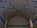
The ceiling of Clandeboye Hall following the 1925 rebuilding


Sports Clubs in Dunlop
Dunlop Golf Club

The Dunlop Golf Course had nine holes. It started at Hapland in 1908 but moved to Templehouse in 1909, where it stayed until it closed in 1922. The course was described as "sporting" and "varied." It was about a twelve-minute walk from the station. Membership fees were very low. In 1914, the club had 150 members. During World War I, military personnel, nurses, and staff at Dunlop House Military Hospital could play for free. The only remaining part of the course is a bunker overlooking the ruins of Templehouse.
Dunlop Curling Pond
An old map shows a local curling pond near Templehouse. It was in Minnie's Meadow and was fed by the Templehouse and Hill Burns. Photos from around 1912/1913 show it was still being used then.
Dunlop Cricket Club
Dunlop had a cricket club near North Netherhouses that could be seen from the railway. The brick scoreboard was the last part of it, but it has now been torn down. The foundations of the old clubhouse can still be seen.
Darts
Dunlop has a very active darts scene with its own league. Players come from Dunlop and nearby areas like Stewarton, Irvine, Kilmarnock, and even Barrhead. In 2020, there were 22 players.
Aiket Castle

Aiket Castle was originally a square tower, typical of homes for lesser noble families. It was once surrounded by a moat. The name 'Aiket' comes from "Oak Wood." The family who lived there, the Cunninghames, were related to the Glencairn family. Alexander Cunninghame was the first recorded person to live at Aiket. Three daughters from Aiket married men involved in the murder of the 4th Earl of Eglinton.
Ancient Sites
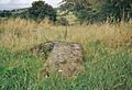
The Carlin Stone or Hag Stone
On top of the Commoncraigs, overlooking Dunlop and the Glazert, is a large boulder called the 'Carlin’s Stone' on maps. A "Carlin" is an old word for an "old hag" or witch. It might also come from the Gaelic word "Cailleach," meaning a witch or the Goddess of Winter. So, this would be the Witch's or Hag's Stone, like several others in Scotland.
-
A view of the Carlin Stone
-
The Carlin stone from the Commoncraigs Community Woodland
-
Illustrating the procumbent position of the stone


Near Stewarton, some farms are named 'Kilbride'. 'Bride' is an English version of the Celtic Goddess Brìghde, linked to the festival of Imbolc (February 1st).
The Thurgatstane or Ogrestane

The Thurgartstone is just outside Dunlop on the Lugton Road, in the valley of the Black Burn. It's in a hidden spot with plenty of water. In the middle of a field near the Chapel Crags is this large stone, also known by many other names like Thorgatstane or Ogrestane. It's a huge rock moved by a glacier, weighing about 25 tons. It's different from the local stone. It sits near the site of the old St. Mary's Chapel and has long been linked to ancient pagan rituals.
The stone has many names. One idea is that it means "Thor's Great Stone." Another is "Thou Great Stone" or simply "great stone." "The Stone of the Ogre" might come from an old legend about how the stone got there. Some names might be old spelling mistakes. Another idea is that it comes from 'Tagairtstane,' meaning "the priest's stone." This ancient stone might have once been a "rocking stone" but is now firmly set in the ground.
Another suggestion is that 'Ogrestane' is more like 'Ogreton,' and 'Ogier' is a Norman version of the Scandinavian name 'Holger'. This could mean that Scandinavians once lived in this valley.
It's said that even in old times, people would crawl on their knees around this stone, saying, "O thou grit stane," believing a god was specially present there. Farmers from Brandleside Farm were required to protect the stone, not moving it or plowing too close, possibly because of old stories of pagan burials around it. Some people remember May Day events being held at the site. It is now a protected historical site. You can see a good view of Dunlop or Borland Hill, where the De Ross family's castle once stood, from the stone.
Monastic Settlement
A Christian center was built near the Thurgartstone to replace the pagan importance of the site. This was a monastic settlement with a chapel dedicated to Saint Mary (NS 4080 5032) and a graveyard. These buildings are now gone, built by monks from Kilwinning Abbey. Only the name 'Saint Mary's' for nearby modern houses, built on the chapel site, reminds us of its past. Chapelhouse Farm is also nearby. The Holy Well still exists, with nearby houses pumping water from it. The water from the well used to flow under the road into a trough. In 1856, water for baptisms in Dunlop Kirk was still taken from this Holy Well.

The small chapel had money set aside to support a chaplain. It was abandoned during the Reformation in Scotland, led by John Knox. Locals took stones from the chapel, and the last ones were removed by a farmer in the 1830s. It stood on a rock from which a stream flowed. This stream was originally crossed by steps called the Lady's steps before the Chapelhouse Bridge was built. A carved piece from the old chapel, thought to be a holy water font, was used as a pig trough for years before being broken up for building material. Steps cut into the rock face led up to the hill behind the chapel, where the monks' graveyard was supposedly located. Some stone pieces from St. Mary's are now kept at North Borland Farm.
Old maps show the Lady's Steps near Hapland Mill. However, local writers from the 1800s and 1900s place the steps at Chapel Crags. It seems strange to name steps after a chapel far away in another valley, suggesting a map error. A field near the 'Druid Stone' is called Templecroft, and the first Celtic church might have been here, later replaced by the Roman Catholic Chapel. It's interesting that the pagan stone is still there, but no signs of the Christian sites are visible, except for the hidden holy well.
Craighead Law Hill

This hill, 687 feet (209 m) high, in the Lugton area of Dunlop Parish, is thought to be a 'moot' or trial hill, where legal meetings or trials were held. The stones on its top don't look accidental, and a grass-covered mound is noticeable. One stone on the summit has a deep hole drilled into it, possibly for a flagpole. A similar setup existed at the Borestone near Beith. Near Aiket Castle is another Court Hill. Halket Loch was a lake covering about 10 acres (40,000 m²) and was drained in the 1840s. A 1913 photo shows a large rock called the 'Lion Rock' because it looked like an animal. Craighead Law can be seen in the distance from there.
Grange
A monastic grange (a farm belonging to a monastery), likely owned by Kilwinning Abbey, might have existed here before the Reformation. This is suggested by many place names like Grangehill, Townhead of Grange, and South Grange. A church field was also located there, and an old road for driving animals ran past Carswell Farm towards Paisley.
The Battle of Boyd's or Craignaught Hill
| Meaning of the Name |
| The name 'Craignaught' comes from the Gaelic words 'Craig' (Rock) and 'Nochdta' (Naked), meaning 'Bare Rock' hill. |
Craignaught Hill is in the northeast of Dunlop Parish, with the Clerkland Burn flowing below it towards Dunlop House. On the lower slopes of Craignaught Hill, a very unusual battle was fought between the Boyd family of Kilmarnock and the Stewart family of Darnley. Sir Alan Stewart had been killed by Sir Thomas Boyd, even though they were supposed to be under a truce. Sir Alan's brother, Alexander Stewart, nicknamed 'buktuth' (meaning he had a large sticking-out tooth), was determined to get revenge.
Sir Thomas Boyd was surprised on the night of July 7, 1439, while riding past Craignaught. Even though he was outnumbered, he and his followers fought on, even taking agreed breaks signaled by a horn. The remaining Boyds stood "back to back, they closed up their ranks, and, forming a circle, they grimly set themselves to beat back the Stewarts or else die where they fought." Eventually, Sir Thomas Boyd was killed, along with many of his followers.
This battle led to many killings and counter-killings across the West of Scotland. Boyd's wife had supposedly dreamed about what would happen and died of sadness days after her husband's death. The 1860 OS map marks 'Boyd's Hill' and 'Boyd's slack' (a Scots word for a narrow pass) to the north of Craignaught.
Boyd's Hill has not been damaged by quarrying (stone digging) or waste disposal at Craignaught. Boyd's slack is also still clearly visible.
Hugh Craig, a writer, was born at Grange Farm, where Boyd's Hill stands. He wrote that the place where the Stewart assassin hid was still pointed out in his day. He gives the battle date as July 9, 1439.
The Gemmells of Templehouse
The Knights Templar are remembered in the name of this property, which was officially called the 'Templeland of Dunlop Hill' but commonly known as Templehouse. Since 1570, it was owned by the Gemmill or Gemmell family. In 1596, Patrick Gemmill gave the Templelands of Dunlop Hill to Lord Torphichen for his eldest son. The Gemmells still owned Templehouse in the 1960s. The house had a walled garden with formal gardens and paths. Today, the house and gardens are in ruins.
The Lands of Hapland
| Meaning of the Name |
| The name might be a changed version of 'Whaup Land'; a 'whaup' is a Scots word for a curlew (a type of bird). |
Before 1549, Hapland was part of the Dunlop estate. David Dunlop traded Hapland for the lands of Borland. In 1612, Patrick Cunninghame sold these lands to Gabriel Porterfield. Gabriel Porterfield also took possession of Dunlop Hill, Wattirland (Waterland), and Halketh, which included a loch (now drained).
The Laird (lord) of Hapland was a leader in Dunlop Parish in 1649 and a captain in the Scottish army when Cromwell was in Scotland. Because of this, his lands were taken away. The last male in his family died around 1765 or 1770 when he fell off his horse. The old mansion house was torn down around 1876 because it was considered old-fashioned. A new farm building was built at the site. It seems that Temple-Ryburn changed its name to Hapland around this time.
Mains Quarry


The Mains Quarry siding was a railway track near Dunlop, between Dunlop and the Gameshill road bridge, on the old G&SWR line. It was a single track running next to the main line. The crushed stone from the quarry was carried to the siding by a narrow-gauge tramway. This tramway was raised on a small hill for about half its length and ran for over 1000 feet (305m) from the Mains Quarry buildings.
The quarry and its tramway were west of the main railway line, between the farms of South Netherhouses and Mains of Aiket. Stone had been quarried at Mains since at least 1856, even before the G&SWR line opened in 1871.
The quarry's narrow-gauge line is shown as a tramway on a 1909–1910 map. By then, it seems it was no longer used, as no railway structures are shown where it met the siding. It's not clear how the stone was moved, but the narrow-gauge line was higher than the siding where they met.
The tramway line curved sharply away from the main line and then ran straight west, next to the quarry, to the old quarry buildings, where the line split. The quarry covered about three acres at that time. Later maps show it was still being worked, using road transport, before it was finally abandoned and allowed to fill with water.
Small Facts About Dunlop
In 1820, only two people in Dunlop were allowed to vote as freeholders (landowners).
A new water supply system was opened for Dunlop in 1896. It brought water from a spring at Sidehead, as the old water supply was deemed unsafe.
Dunlop and Stewarton are both on the old turnpike road, which was finished in 1820. This road connected Glasgow to Kilmarnock, Irvine, and Ayr.
Dunlop Cattle are said to have started in the parish. They were bred by the Dunlop family from improved cows from Holland between 1550 and 1700. This breed, also known as Cunninghame or Ayrshire cattle, are white and brown, with short legs, long horns, and straight backs. The bulls can be fiery, but the cows are usually calm and gentle. They produce milk that is very rich in butterfat.
The lands of Netherhill were bought by John Love of Threepwood in the early 1800s.
Freemasonry
Freemasonry in Dunlop began in the early 1800s. On May 4, 1824, a special permission (charter) was given to the members of Dunlop to practice Freemasonry. This continued for many years as Lodge Dunlop Caledonian No 311. It was declared inactive in 1881 because no updates had been sent to the main Grand Lodge for over seven years. The first master of this lodge was John Gemmell, and the first secretary was Robert Fulton. The lodge colors were crimson with a tartan trim.
On October 19, 1944, a meeting was held in the public school by the local schoolmaster, Mr. Peter Calderwood. He was a member of another lodge, and 38 other members from various lodges attended.
After several letters between the Grand Lodge and Peter Calderwood, a meeting was held on March 29, 1945, to choose the leaders for a new lodge. A letter was sent to Edinburgh (Grand Lodge of Scotland) with a list of 110 people who wanted to join on April 20, and a new charter was granted. Because so many years had passed, they could not get the original lodge number or colors. Today, the colors are green with gold trim.
The official opening and blessing of the new Lodge, Lodge Dunlop Caledonia No 1408, took place in Dunlop Public Hall on November 3, 1945. Many members attended, including groups from 48 other lodges. A total of 341 members signed the attendance book to see Joseph Johnston installed as the first Master of Lodge Dunlop Caledonia No 1408. A collection for the lodge's charity raised £34 and 6 shillings.
After the meeting, 110 members had a meal that cost 6 shillings (about 30p) per person. At a meeting on November 22, William Stevenson, Archiebald Howie, and Archibald Baillie were the first new members of the lodge. Since then, 229 people have joined the lodge.
Across Scotland, nine lodges have "Caledonian" in their name. On September 24, 1983, the first of the yearly 'Caledonian Gatherings' was held in Annan. Each lodge takes turns hosting this event. Dunlop Caledonia No 1408 hosted it for the third time on September 19, 2016.
The members of the lodge elected Jimmy Laing as their master in October 2019, and he was installed on December 13, 2019. The lodge meets on the second and fourth Thursday of the month, except from May to August.
|
See also
 In Spanish: Dunlop (East Ayrshire) para niños
