East London facts for kids

East London is a large area in the northeastern part of London, England. It lies to the east of the old City of London and north of the River Thames. This area grew into London's main docklands (places where ships load and unload goods) and a big industrial centre. In the 1800s, new railways helped East London expand even further, creating many new suburbs (neighborhoods). Today, many of the old industrial areas in East London are being rebuilt and made modern, like Canary Wharf.
Contents
History of East London

How East London Got Its Name
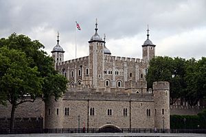
The name "London" is very old, but we don't know exactly where it came from. The idea of "East London" as a separate area is quite new. In 1720, a map described this area as "That Part Beyond the Tower," referring to the Tower of London.
Later, in the late 1800s, people started using the term East End of London for the areas right next to the City of London. In 1889, a man named Charles Booth said East London was the part of the County of London between the City of London and the River Lea.
Today, East London usually includes seven London boroughs (local areas): Barking and Dagenham, Hackney, Havering, Newham, Redbridge, Tower Hamlets, and Waltham Forest.
How East London Grew
The East End of London, which is the older part of modern East London, started growing in the Middle Ages. This happened as London expanded beyond its old city walls. Growth was slower in the east because of marshy, wet areas.
However, in the 1500s, more people began to move there. Industries linked to the River Thames, like shipbuilding and the docks, encouraged this growth. By 1650, Shadwell was already a busy port town.
By the early 1800s, the docks in Tower Hamlets were getting too full. So, in 1855, the Royal Victoria Dock was opened in Newham. By 1882, East London was so big that people like Walter Besant described it as a city on its own.
Trains Help East London Grow
Most of the railway lines in East London were built within 50 years, starting in 1839. The first line went from Mile End to Romford in 1839. Then, the London and Blackwall Railway built a line from Minories to Blackwall in the same year.
These new train lines made places like Stratford important railway hubs. Trains helped connect different parts of East London and made it easier for people to travel and for goods to be moved.
More areas further east developed in the Victorian and Edwardian eras (late 1800s and early 1900s) because of these railways. New homes were built, and later, large social housing estates like Becontree (in the 1920s) and Harold Hill (after World War II) were added. The growth of the city was limited by protecting Epping Forest in 1878 and later by creating the Metropolitan Green Belt (an area of protected open land). New industries also started, such as Ford's car factory at Dagenham.
Changes: From Factories to New Buildings
Many of East London's old industries started to decline in the late 1900s. But now, East London is an area of big changes and new developments. The London Docklands area, for example, was completely redeveloped in the 1980s.
Today, the Thames Gateway project is bringing more new activity to East London. This includes areas like the Lower Lea Valley around the Olympic site and London Riverside along the Thames.
Governance of East London
Seven London boroughs cover the areas of Greater London north of the Thames and east of the City of London. These are: Barking and Dagenham, Hackney, Havering, Newham, Redbridge, Tower Hamlets, and Waltham Forest. Each borough has its own local council that manages local services.
Some bigger decisions for London are made by the Greater London Authority, which includes the Mayor of London and the London Assembly.
| Borough | Barking and Dagenham | Hackney | Havering | Newham | Redbridge | Tower Hamlets | Waltham Forest |
|---|---|---|---|---|---|---|---|
| Location |  |
 |
 |
 |
 |
 |
 |
| Local authority | Barking and Dagenham LBC | Hackney LBC | Havering LBC | Newham LBC | Redbridge LBC | Tower Hamlets LBC | Waltham Forest LBC |
| London Assembly constituency | City and East | North East | Havering and Redbridge | City and East | Havering and Redbridge | City and East | North East |
| Inner/Outer London | Outer | Inner | Outer | Outer | Outer | Inner | Outer |
| Major centres | Barking | Dalston | Romford | Stratford, East Ham | Ilford | Canary Wharf | Walthamstow |
Geography of East London
East London is located in the lower Thames valley. The main rivers here are the Thames, which forms the southern border, and the Lea, which separates Tower Hamlets/Hackney from Newham/Waltham Forest. Other rivers include the Roding and the Beam.
The marshy areas along the Thames, which once stretched for miles, are now almost completely gone. East London is generally the lowest part of London because of the wide Thames. The only hills are in the northern parts of Havering, Redbridge, and Waltham Forest, further away from the river.
People of East London
In Tower Hamlets, the population reached its highest point in 1891. After that, growth mostly happened in the outer boroughs. By 1971, the population was actually decreasing in every borough.
However, by the 2011 census, this trend had changed, and every borough saw some population growth. By the 2021 census, Barking and Dagenham, Havering, and Redbridge had more people than ever before. The total population of this area in 2021 was 1.9 million people.
Here's how the population changed between 1801 and 2021:
Transport in East London
River Crossings
The City of London and West London have many bridges connecting them to South London. However, East London only has Tower Bridge at its very edge. This is because the River Thames gets much wider further east. Also, for a long time, it was important not to block the river traffic going to the London Docklands.
Until the late 1900s, East London was connected to the South by only one railway line, the East London Line. But things have improved! The Jubilee Line Extension opened in 1999, and new parts were added to the Docklands Light Railway and the Elizabeth line. A cable car service also opened in 2012.
There are road tunnels like the Rotherhithe and Blackwall tunnels. Further east, you can use the Woolwich Ferry to cross the river. There are also special tunnels for people to walk through, like the Greenwich and Woolwich foot tunnels.
 | Percy Lavon Julian |
 | Katherine Johnson |
 | George Washington Carver |
 | Annie Easley |

