Eddy County, New Mexico facts for kids
Quick facts for kids
Eddy County
|
|
|---|---|

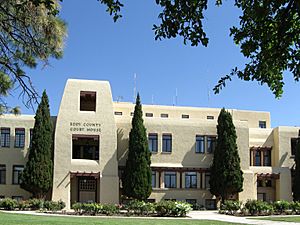
Eddy County Courthouse in Carlsbad
|
|

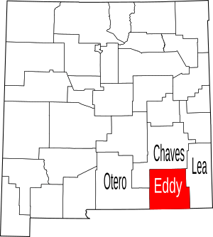
Location within the U.S. state of New Mexico
|
|
 New Mexico's location within the U.S. |
|
| Country | |
| State | |
| Founded | May 16, 1891 |
| Named for | Charles Eddy, a local rancher |
| Seat | Carlsbad |
| Largest city | Carlsbad |
| Area | |
| • Total | 4,198 sq mi (10,870 km2) |
| • Land | 4,176 sq mi (10,820 km2) |
| • Water | 22 sq mi (60 km2) 0.5%% |
| Population
(2020)
|
|
| • Total | 62,314 |
| • Density | 14.8437/sq mi (5.7312/km2) |
| Time zone | UTC−7 (Mountain) |
| • Summer (DST) | UTC−6 (MDT) |
| Congressional district | 2nd |
Eddy County is a county in the state of New Mexico. In 2020, about 62,314 people lived there. Its main city and county seat is Carlsbad.
The county was created in 1891. It is located just north of the Texas state line. Eddy County includes the Carlsbad-Artesia area. Carlsbad Caverns National Park is also found here.
Contents
History of Eddy County
Early Ranching Days
In 1866, cowboys like Charles Goodnight and Oliver Loving brought large groups of cattle through the Pecos River area. They set up "cow camps" in places like Seven Rivers and what is now Carlsbad. John Chisum later joined them, bringing many thousands of cattle.
Charles Eddy and Water Projects
In 1881, Charles B. Eddy came to the area. With his brother, John, and partner Amos Bissell, he started the Eddy-Bissell Cattle Company. In 1884, they began the Halagueno Ranch. This ranch covered a large area from Seven Rivers to La Huerta (a part of Carlsbad).
Charles Eddy wanted to bring more people to settle in the area. He built a ditch to move water from the Pecos River in 1887. He called his company the Pecos Valley Land and Ditch Company. He hoped to attract people from Europe to the sunny climate.
Founding the Town of Eddy
In 1888, Patrick Garrett (a famous sheriff) and Charles Greene worked with Eddy. They planned a system of canals to bring water to their ranches. They found investors, including J.J. Hagerman. These men planned a new town on the Pecos River. They officially named the town Eddy on September 15, 1888.
The county was named after Charles B. Eddy. When Eddy County was formed in 1889, Seven Rivers was first chosen as the county seat. But in 1890, people voted to move the county seat to the town of Eddy. Charles Eddy gave land for a new courthouse. In 1899, the town of Eddy changed its name to Carlsbad.
Growth and Discoveries
On January 10, 1891, the first train arrived in Eddy on the new Pecos Valley Railroad. This made it easier to move crops like cotton and alfalfa, as well as cattle and wool. More people and investors came to the area.
In 1902, the amazing Carlsbad Caverns were discovered. They are about 18 miles (29 km) southwest of Carlsbad. It's still debated who found them first, Jim White or Abijah Long. These caves are now part of Carlsbad Caverns National Park. Millions of visitors from all over the world have come to see them.
Oil was found in Eddy County in 1909 near Dayton. Another big oil discovery happened in 1923 near Artesia. This made southeastern New Mexico a major oil-producing area. By 1938, the oil produced here was worth a lot of money.
In 1925, a scientist named Dr. V. H. McNutt found large amounts of potash east of Carlsbad. Potash is a mineral used in fertilizer. This led to a "boom" in potash mining, and many large companies started mining in the area.
Geography of Eddy County
Eddy County covers about 4,198 square miles (10,873 km²). This is almost four times the size of the entire state of Rhode Island! Most of this area, about 4,176 square miles (10,816 km²), is land. Only a small part, 22 square miles (57 km²), is water.
The lowest point in New Mexico is in Eddy County. It's on the Red Bluff Reservoir, where the Pecos River flows into Texas.
Neighboring Counties
- Otero County - to the west
- Chaves County - to the north
- Lea County - to the east
- Loving County, Texas - to the southeast
- Reeves County, Texas - to the south
- Culberson County, Texas - to the south
Protected Natural Areas
- Carlsbad Caverns National Park
- Lincoln National Forest (part of it)
Population of Eddy County
| Historical population | |||
|---|---|---|---|
| Census | Pop. | %± | |
| 1900 | 3,229 | — | |
| 1910 | 12,420 | 284.6% | |
| 1920 | 9,116 | −26.6% | |
| 1930 | 15,842 | 73.8% | |
| 1940 | 24,311 | 53.5% | |
| 1950 | 40,640 | 67.2% | |
| 1960 | 50,783 | 25.0% | |
| 1970 | 41,119 | −19.0% | |
| 1980 | 47,855 | 16.4% | |
| 1990 | 48,605 | 1.6% | |
| 2000 | 51,658 | 6.3% | |
| 2010 | 53,829 | 4.2% | |
| 2020 | 62,314 | 15.8% | |
| U.S. Decennial Census 1790-1960 1900-1990 1990-2000 2010 |
|||
In 2020, Eddy County had a population of 62,314 people.
Communities in Eddy County
Cities
Villages
Census-designated places
These are areas that are like towns but are not officially incorporated as cities or villages.
Ghost Towns
These are towns that used to exist but are now abandoned.
- Avalon
- Barber Crossing
- Four Forks
- Four Wells
- Harkey Crossing
- Hunter Place
- Lookout
- Red Bluff
- Illinois Camp
- Three Forks
Education in Eddy County
Here are the school districts that serve different parts of Eddy County:
- Artesia Public Schools
- Carlsbad Municipal Schools
- Loving Municipal Schools
See also
 In Spanish: Condado de Eddy (Nuevo México) para niños
 | Delilah Pierce |
 | Gordon Parks |
 | Augusta Savage |
 | Charles Ethan Porter |


