
Manalapan Township, New Jersey facts for kids
Quick facts for kids
Manalapan Township, New Jersey
|
||
|---|---|---|
|
Township
|
||

Rolling hills of Monmouth Battlefield and farmland
|
||
|
||
| Motto(s):
A great place to live
|
||

Location of Manalapan Township in Monmouth County highlighted in yellow (right). Inset map: Location of Monmouth County in New Jersey highlighted in black (left).
|
||

Census Bureau map of Manalapan Township, New Jersey
<mapframe text="Interactive map of Manalapan Township, New Jersey" latitude="40.28238888888889" longitude="-74.3466111111111" zoom="8" width="250" height="250"> { "type": "ExternalData", "service": "geoshape", "ids": "Q3016629" } </mapframe> |
||

Manalapan Township, New Jersey
Location in Monmouth County, New Jersey

Manalapan Township, New Jersey
Location in New Jersey

Manalapan Township, New Jersey
Location in the United States
|
||
| Country | ||
| State | ||
| County | Monmouth | |
| Incorporated | March 9, 1848 | |
| Named for | The Lenape translation of "Manalapan" | |
| Government | ||
| • Type | Township | |
| • Body | Township Committee | |
| Area | ||
| • Total | 30.88 sq mi (79.99 km2) | |
| • Land | 30.65 sq mi (79.39 km2) | |
| • Water | 0.23 sq mi (0.60 km2) 0.75% | |
| Area rank | 85th of 565 in state 8th of 53 in county |
|
| Elevation | 102 ft (31 m) | |
| Population
(2020)
|
||
| • Total | 40,905 | |
| • Estimate
(2023)
|
40,506 | |
| • Rank | 58th of 565 in state 4th of 53 in county |
|
| • Density | 1,334.5/sq mi (515.3/km2) | |
| • Density rank | 351st of 565 in state 43rd of 53 in county |
|
| Time zone | UTC−05:00 (Eastern (EST)) | |
| • Summer (DST) | UTC−04:00 (Eastern (EDT)) | |
| ZIP Code |
07726 – Englishtown
|
|
| Area code(s) | 732/848 | |
| FIPS code | 3402542990 | |
| GNIS feature ID | 0882117 | |

Manalapan Township is a community in western Monmouth County, New Jersey. It's part of the larger New York metropolitan area. In 2020, about 40,905 people lived here. This was the highest number of people ever recorded in the township!
The name "Manalapan" comes from the Lenape language. It can mean "land of good bread," "good land to settle upon," or "covered swamp with edible roots."
Contents
History of Manalapan

A very important event, the Battle of Monmouth, happened here in 1778. This battle was part of the American Revolutionary War. Today, a large area called Monmouth Battlefield State Park covers 2,928 acres in Manalapan and nearby Freehold Township.
Manalapan Township officially became a township on March 9, 1848. It was created from parts of Freehold Township. Later, Englishtown became its own separate town in 1888, taking some land from Manalapan.
Exploring Manalapan's Geography

Manalapan Township covers about 30.88 square miles (79.99 square kilometers). Most of this area is land, with a small part being water. The township is about 102 feet above sea level.
Manalapan completely surrounds the town of Englishtown. This makes it one of 21 "doughnut towns" in New Jersey, where one town is entirely inside another!
Manalapan shares borders with several other towns. In Monmouth County, it borders Freehold Township, Marlboro Township, and Millstone Township. It also borders Monroe Township and Old Bridge Township in Middlesex County.

Yorketown is a community located within Manalapan Township. Other smaller communities and places in the township include Cahills Corners, Clarks Mills, Elton, and Millhurst.
Natural Environment
Manalapan Township is home to a type of natural vegetation called Appalachian Oak forest. This means you'll find many oak trees and other Hardwood trees growing naturally here.
Population and People

Manalapan has grown quite a bit over the years. In 1850, there were about 1,910 people. By 2020, the population had grown to 40,905. This shows how much the township has developed!

In 2010, there were 38,872 people living in Manalapan. About 25.8% of the people were under 18 years old. The average age in the township was 41.7 years.

Parks and Fun Activities
.jpg)

Manalapan has a huge Recreation Center that covers 162 acres. It has lots of things to do! You can find fields for softball, baseball, and football. There are also courts for basketball, tennis, and street hockey. For younger kids, there are tot lots. The center also has a fitness trail, a disc golf course, and even a small water park. It's a great place for families to play and relax.
Schools in Manalapan
.jpg)
Students in Manalapan Township from pre-kindergarten through eighth grade go to schools in the Manalapan-Englishtown Regional School District. This district also includes students from Englishtown. Most of the students (about 95%) are from Manalapan. The district has eight schools, including the John I. Dawes Early Learning Center, Clark Mills School, and Manalapan-Englishtown Middle School.
For high school, students from Manalapan Township attend either Freehold Township High School or Manalapan High School. These schools are part of the Freehold Regional High School District. This district serves students from several nearby towns.
Students in Monmouth County, including Manalapan, can also choose to attend one of the Monmouth County Vocational School District's special career academies. Manalapan's local academy focuses on Science and Engineering.
Historic Places
The Monmouth Battlefield Historic District is a special area within the larger Monmouth Battlefield State Park. It's important because of its role in the Battle of Monmouth.
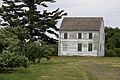
This district still has some old farmhouses from the colonial era. Three of the original seven farmhouses that were there during the battle are still standing: the Sutfin Farmhouse (built in 1731), the Rhea-Applegate House (1745), and the Craig House (1746).
The district was added to the National Register of Historic Places in 1966. This means it's a nationally recognized historic site.
Community Life

Manalapan has several important landmarks. These include the main building for the Monmouth County Library, the Manalapan Recreation Center, and the famous Battle of Monmouth battlefield.
Every year, Manalapan hosts a community event called "Manalapan Under the Stars." It features rides, concerts, fireworks, and other fun activities for everyone.

In 2004, Money magazine called Manalapan the second "hottest town" on the East Coast.
On May 27, 2001, a tornado hit Manalapan. It caused over $1 million in damage. The tornado had winds up to 120 miles per hour.
Getting Around Manalapan
_in_Manalapan_Township,_Monmouth_County,_New_Jersey.jpg)
Manalapan has many roads. As of 2010, there were about 192 miles of roadways. Most of these are maintained by the township itself.
Major roads like U.S. Route 9 and State Route 33 pass through Manalapan. Other important county roads like 522 and 527 also go through the area.
If you need to travel further, major highways like the Garden State Parkway and Interstate 195 are nearby. The New Jersey Turnpike is also easily accessible.
Public Transportation
Trains
In the past, Manalapan and Englishtown had a major railway called the Freehold and Jamesburg Agricultural Railroad. It was built in the 1850s and helped the region become a transportation center. This railway was closed by the early 1930s.
Today, there's a plan called the Monmouth Ocean Middlesex Line to bring passenger train service back to the area. Manalapan Township could be a stop on this new line.
For now, the closest train stations are Metropark, Metuchen, New Brunswick, and Princeton Junction. These stations are on the Northeast Corridor Line.
Buses
NJ Transit offers bus services from Manalapan. You can take a bus on route 139 to the Port Authority Bus Terminal in Midtown Manhattan. Routes 64 and 67 go to Newark.
Airports
The closest airport for short flights is Old Bridge Airport. For bigger trips, the nearest major airports are Trenton-Mercer Airport (about 21 miles west) and Newark Liberty International Airport (about 32 miles north). Newark Liberty is a major airport with many flights.
Healthcare Services
Manalapan Township is served by CentraState Medical Center, located in nearby Freehold Township. This hospital has 287 beds and is connected with Rutgers Robert Wood Johnson Medical School. CentraState also has family doctor offices in nearby towns like Marlboro Township and Monroe Township.
Other hospitals close to Manalapan include Raritan Bay Medical Center in Old Bridge Township, Penn Medicine Princeton Medical Center in Plainsboro Township, and Saint Peter's University Hospital and Robert Wood Johnson University Hospital in New Brunswick.
Famous People from Manalapan
Many interesting people have lived in or are connected to Manalapan Township. Here are a few:
- Robby Andrews (born 1991), an Olympic runner.
- Jim Babjak (born 1957), a guitarist for the band the Smithereens.
- Alyssa Campanella (born 1990), who was crowned Miss USA 2011.
- David DeJesus (born 1979), a former professional baseball player.
- Dylan Dreyer (born 1981), a meteorologist on Weekend Today.
- Anthony Firkser (born 1995), a professional football player.
- Jay Glazer (born 1969), a sportswriter and football insider for Fox Sports.
- Nick Mara (born 1997), a singer and dancer.
- Johnny Petraglia (born 1947), a professional bowler who won many titles.
- Dan Smith (born 1989), a professional poker player.
- Mike "The Situation" Sorrentino (born 1981), a TV personality from Jersey Shore.
Images for kids
-
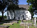
1753 Old Tennent Church
-
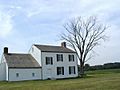
1746 Craig House
-

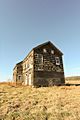
1872 Cobb House
-

Molly Pitcher Spring
-
1731 Sutfin House
-
1745 Rhea Applegate House
.JPG)


See also
 In Spanish: Municipio de Manalapan para niños
