
Erie National Wildlife Refuge facts for kids
Quick facts for kids Erie National Wildlife Refuge |
|
|---|---|
|
IUCN Category IV (Habitat/Species Management Area)
|
|
 |
|

Erie National Wildlife Refuge
Location in Pennsylvania
|
|
| Location | Crawford, Pennsylvania, United States |
| Area | 13.75 sq mi (35.6 km2) |
| Established | May 22, 1959 |
| Visitors | 30,000 |
| Operator | United States Fish and Wildlife Service |
The Erie National Wildlife Refuge is a huge natural area in Crawford County, Pennsylvania. It covers about 8,777-acre (3,552 ha) of land. This special place was created to give waterfowl (like ducks and geese) and other migratory birds a safe home. It helps them find places to nest, eat, raise their young, and rest during their long journeys.
The refuge is split into two main parts. The Sugar Lake Division is about 5,206-acre (2,107 ha). It's near Guys Mills, Pennsylvania and east of Meadville. The Seneca Division is 3,571 acres (1,445 ha) and is north of the Sugar Lake Division. It's close to French Creek and Cambridge Springs, Pennsylvania.
The National Audubon Society has called the Erie National Wildlife Refuge an Important Bird Area. This is because it has many different types of habitats. These habitats attract around 237 different kinds of birds!
Contents
History of the Refuge
The Erie National Wildlife Refuge officially opened on May 22, 1959. The land for the refuge was bought using money from special stamps. These stamps are called "Duck Stamps." People who hunt migratory birds buy these stamps. The money helps protect wetlands and wildlife habitats.
The Land and Its Habitats
The Erie Refuge has two main sections, each with unique features.
Sugar Lake Division
This part of the refuge is 5,206 acres (2,107 ha). It sits in a narrow valley. Woodcock Creek flows north through it, and Lake Creek flows south. You'll find many beaver ponds, small pools, and marshlands along these creeks. Forests cover the slopes around them. There are also open fields, grasslands, and wet meadows.
Seneca Division
The Seneca Division is 3,571 acres (1,445 ha). It's in a forested valley. Muddy Creek and Dead Creek create most of the wetland areas here. French Creek also flows through this part of the refuge. Over 80 types of native fish live in French Creek!
Wetlands and Water Control
More than 2,500 acres (1,000 ha) of the refuge are wetlands. This includes beaver ponds, marshes, swamps, and man-made ponds. There are also creeks and wet meadows. All these areas are perfect homes for many migratory birds and waterfowl.
The refuge uses special structures to control water levels in its ponds. This helps create the best conditions for waterfowl. It also encourages the growth of plants that birds like to eat.
Grasslands and Farming
Grasslands near the wetlands are important. They provide safe places for ground-nesting waterfowl to lay their eggs. The refuge sometimes uses controlled burning on about 100 acres (40 ha) of these grasslands each year. This helps keep the grasslands healthy.
The refuge also has a special farming program. Farmers grow crops like oats, grass, clover, and corn on refuge lands. In return, they leave some of the crops in the fields. This extra food helps feed the wildlife, especially in winter.
Wildlife and Protected Species
The Erie National Wildlife Refuge is home to many different animals. Its varied habitats attract over 237 kinds of birds. There are also 47 types of mammals and 37 kinds of amphibians and reptiles.
Some very special and rare animals live here. These include the endangered northern riffleshell and clubshell mussels. These are types of freshwater mussels.
Birds of the Refuge
With 237 bird species, the refuge is a birdwatcher's paradise. About 113 bird species actually nest here.
During migration, the refuge is a resting spot for thousands of ducks and Canada geese. Other common migrating birds include wood ducks, mallards, blue-winged teal, and hooded mergansers. You might also see pintails, green-winged teal, American wigeon, scaup, bufflehead, golden-eye, ring-necked ducks, and black ducks.
Wood ducks are the most common nesting waterfowl. The refuge helps them by putting out special nesting boxes. Hooded mergansers, mallards, blue-winged teal, and Canada geese also nest here.
You might even spot majestic Bald eagles nesting in the refuge. Ospreys also visit to hunt for fish. Red-tailed hawks and American kestrels are common birds of prey that nest here.
In summer, small groups of sandpipers and yellowlegs feed on the mudflats. Large great blue herons are also noticeable marsh birds. They nest together in groups called rookeries on the refuge.
Mammals of the Refuge
About 47 different kinds of mammals live at the refuge. Sometimes, people even see bobcats! The animals you are most likely to spot include black bears, skunks, white-tailed deer, coyotes, raccoons, beavers, foxes, river otters, muskrats, and woodchucks.
Fish in the Waters
The refuge's waters are home to many fish. Common warm water fish include black crappie, yellow perch, largemouth bass, bluegills, sunfish, and bullheads. In colder waters like Woodcock Creek, you can find trout and white suckers.
Natural Plant Life
The main type of natural plant life at Erie National Wildlife Refuge is a Northern hardwood forest. This means you'll find many different kinds of Hardwood trees growing here.
Climate of the Refuge
The Erie National Wildlife Refuge has a Temperate Continental climate. This means it has warm summers and cold winters. It gets rain and snow throughout the year.
Summers are usually comfortably humid. But sometimes, it can get very hot and humid. Winters can be very cold and windy. The average yearly snowfall is about 80 inches (203 cm). Heavy snowstorms and Ice storms are common, especially from Lake-effect snow and Nor'easters.
Visitor Facilities
The refuge has a visitor center with a 60-seat auditorium. There's also an indoor area where you can watch birds.
You can enjoy fishing in nine public areas. Hunting is also allowed for certain animals. These include eleven small game species, eight migratory bird species, and three big game species like deer, wild turkey, rabbit, and waterfowl.
Other ways to explore the refuge include a driving route, a special blind for watching waterfowl and wildlife, and the Deer Run Overlook and Kiosk.
Trails for Exploring
There are 6 miles (9.7 km) of hiking trails at the refuge. These include four nature trails. They range from 1⁄2-mile (0.80 km) to 3 miles (4.8 km) long. One of the trails is even accessible for people with disabilities.
Muddy Creek Holly Trail
This 1 mile (1.6 km) trail is mostly flat. It goes through meadows, marshes, and forests. A 4-foot-wide (1.2 m) boardwalk makes it easy to walk, even when it's wet. At the end of the trail, you can see parts of an old iron bridge.
Deer Run Trail
The Deer Run Trail is 3 miles (4.8 km) long. It loops through different habitats. You'll see forests, meadows, and thick bushes near the refuge's ponds. This trail is also popular for cross-country skiing in winter.
Tsuga Trail
The Tsuga Trail is a loop trail near the refuge Headquarters. It's about 1.2-mile (1.9 km) to 1.6-mile (2.6 km) long. The shorter loop has numbered signs that match a leaflet. This leaflet explains what you see at each stop. The trail is covered with wood chips, making it comfortable to walk on all year. Bridges take you over small streams and a beaver pond. This trail is easy to walk, with no steep hills.
Along the Tsuga Trail, you'll see many different habitats. These include grasslands, wetlands with birds and amphibians, mixed forests, and cool, dark hemlock groves. You're sure to see lots of wildlife here!
Beaver Run Trail
Beaver Run Trail is a 1 mile (1.6 km) loop. It takes you through woods, past farm fields, and by beaver ponds. These ponds are rich with aquatic life.
Near the Beaver Run Trail, you can find an old sandstone springhouse. People used it to keep milk and food cool. The stones for the springhouse came from the local area.
Images for kids
-
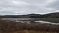
Scenery along the Tsuga Trail.

