
Fayette County, Iowa facts for kids
Quick facts for kids
Fayette County
|
|
|---|---|

|
|

Location within the U.S. state of Iowa
|
|
 Iowa's location within the U.S. |
|
| Country | |
| State | |
| Founded | 1837 |
| Named for | Marquis de Lafayette |
| Seat | West Union |
| Largest city | Oelwein |
| Area | |
| • Total | 731 sq mi (1,890 km2) |
| • Land | 731 sq mi (1,890 km2) |
| • Water | 0.5 sq mi (1 km2) 0.07% |
| Population
(2020)
|
|
| • Total | 19,509 |
| • Density | 26.688/sq mi (10.304/km2) |
| Time zone | UTC−6 (Central) |
| • Summer (DST) | UTC−5 (CDT) |
| Congressional district | 2nd |
Fayette County is a special area in the state of Iowa, U.S.. It's like a big neighborhood with its own local government. In 2020, about 19,509 people lived here. The main town, or county seat, where the county government is located, is West Union.
Contents
History of Fayette County
Fayette County was created a long time ago, on December 21, 1837. Back then, it was part of something called the Wisconsin Territory.
The county was named after a very important person: Gilbert du Motier, marquis de La Fayette. He was a French general and politician. He came to America in 1777 to help fight in the American Revolutionary War. He even became a Major General in the Continental Army!
When Fayette County was first formed, it was much bigger. It included parts of what are now Minnesota and the Dakotas. But over time, its size changed. It became part of the Iowa Territory in 1838. Later, in 1843 and 1847, it became smaller, fitting within the borders of modern Iowa. The county officially started its government in 1850.
Geography of Fayette County
Geography is all about the land and its features. Fayette County covers a total area of about 731 square miles. Almost all of this is land, with only a tiny bit (0.5 square miles) being water.
Main Roads in Fayette County
These are some of the important highways that run through Fayette County, helping people travel around:
 U.S. Highway 18
 Iowa Highway 3
 Iowa Highway 56
 Iowa Highway 93
 Iowa Highway 150
 Iowa Highway 187
 Iowa Highway 281
Neighboring Counties
Fayette County shares its borders with several other counties. These are its neighbors:
- Allamakee County (to the northeast)
- Black Hawk County (to the southwest)
- Buchanan County (to the south)
- Bremer County (to the west)
- Chickasaw County (to the northwest)
- Clayton County (to the east)
- Delaware County (to the southeast)
- Winneshiek County (to the north)
People and Population in Fayette County
Demographics is the study of populations. It helps us understand how many people live in an area and what they are like.
| Historical population | |||
|---|---|---|---|
| Census | Pop. | %± | |
| 1850 | 825 | — | |
| 1860 | 12,073 | 1,363.4% | |
| 1870 | 16,973 | 40.6% | |
| 1880 | 22,258 | 31.1% | |
| 1890 | 23,141 | 4.0% | |
| 1900 | 29,845 | 29.0% | |
| 1910 | 27,919 | −6.5% | |
| 1920 | 29,251 | 4.8% | |
| 1930 | 29,145 | −0.4% | |
| 1940 | 29,151 | 0.0% | |
| 1950 | 28,294 | −2.9% | |
| 1960 | 28,581 | 1.0% | |
| 1970 | 26,898 | −5.9% | |
| 1980 | 25,488 | −5.2% | |
| 1990 | 21,843 | −14.3% | |
| 2000 | 22,008 | 0.8% | |
| 2010 | 20,880 | −5.1% | |
| 2020 | 19,509 | −6.6% | |
| 2023 (est.) | 19,210 | −8.0% | |
| U.S. Decennial Census 1790–1960 1900–1990 1990–2000 2010–2018 |
|||

2020 Census Information
The 2020 census counted 19,509 people living in Fayette County. This means there were about 26.7 people for every square mile. Most people (96.09%) reported being of one race. There were 9,298 homes, and 8,174 of them were lived in.
2010 Census Information
In the 2010 census, the population of Fayette County was 20,880. There were 9,558 homes, and 8,634 of them were occupied.
Communities in Fayette County
Fayette County has several towns and cities where people live.
Cities in Fayette County
Unincorporated Communities
These are smaller communities that don't have their own city government:
Townships in Fayette County
Fayette County is also divided into twenty smaller areas called townships. These help organize the county:
- Auburn
- Banks
- Bethel
- Center
- Clermont
- Dover
- Eden
- Fairfield
- Fremont
- Harlan
- Illyria
- Jefferson
- Oran
- Pleasant Valley
- Putnam
- Scott
- Smithfield
- Union
- Westfield
- Windsor
Largest Cities in Fayette County
Here are some of the largest cities in Fayette County, based on the 2020 census:
- Oelwein is the largest city with 5,920 people.
- West Union is the county seat and has 2,490 people.
- Sumner (mostly in Bremer County) has 2,030 people.
- Fayette has 1,256 people.
- Fairbank (partially in Buchanan County) has 1,111 people.
Images for kids
-
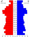
This chart shows the age and gender of people in Fayette County in 2022.

See also
 In Spanish: Condado de Fayette (Iowa) para niños
