
French Frigate Shoals facts for kids


The French Frigate Shoals (in Hawaiian: Kānemilohaʻi) is the largest atoll in the Northwestern Hawaiian Islands. It was named after French explorer Jean-François de La Pérouse. He almost lost two of his frigate ships here while trying to sail through the shallow waters.
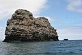
This atoll is made up of a reef that is about 20 miles (32 km) long and shaped like a crescent moon. It also has twelve sandbars and a tall rock called La Perouse Pinnacle. This pinnacle is 120 feet (37 meters) high and is the only part left of the original volcano. The total land area of all the small islands is about 61.5 acres (24.9 hectares). The coral reef area is much larger, over 232,000 acres (93,900 hectares).
Tern Island is the largest island, about 26 acres (10.5 hectares). It has a landing strip and a small group of people who live there. This island is a field station for the United States Fish and Wildlife Service. It is part of the Hawaiian Islands National Wildlife Refuge. The French Frigate Shoals are about 487 nautical miles (902 km) northwest of Honolulu.
In the 20th century, the shoals were important during World War II. They were used by Japan to plan an attack on Hawaii. Later, the U.S. Navy built a small base there to prevent future attacks. After the war, the U.S. Coast Guard used it for a LORAN station, which was a radio navigation system. Today, the French Frigate Shoals are mainly used for studying the ocean and its wildlife. They are a protected nature reserve. Scientists have studied plastic pollution here. In 2020, one island was even named as being polluted by ocean plastic. The reefs here have survived many big Pacific storms. However, these storms have damaged buildings, hurt wildlife, and made some islands much smaller.
Contents
History of the Shoals
.jpg)

People from the main Hawaiian Islands likely visited the French Frigate Shoals first. These islands were settled by Polynesians between 1100 and 1300 AD. There is no strong proof of many people living there for a long time.
The Hawaiian islands were not on the usual routes for early European explorers. So, the shoals were not known to the outside world until La Pérouse almost had a disaster there. On November 6, 1786, La Pérouse was sailing west from Monterey to Macau. During the night, his sailors saw waves breaking right in front of their ships, only about a thousand feet away. Both his ship, the Boussole, and its partner ship, the Astrolabe, quickly turned around. They passed very close to the breaking waves.
At sunrise, the ships returned and mapped the southeastern part of the atoll. They also found the rock that would later be named after La Pérouse. He called the shoals Basse des Frégates Françaises, which means "Shoal of the French Frigates." His expedition also discovered nearby Necker Island. La Pérouse was on an exploration mission for the French Academy of Sciences. They made many discoveries across the Pacific Ocean. Sadly, the expedition was lost at sea in 1788, but their important logs were sent home.
In 1823, a whaling ship called Two Brothers sank near Shark Island. This shipwreck was found in the early 21st century.
In 1859, the U.S. Navy officially claimed the French Frigate Shoals for the United States. This was done by Lieutenant John Mercer Brooke. He was sailing on the ship USS Fenimore Cooper. This claim was made under the Guano Islands Act. This act allowed Americans to claim islands with guano (bird droppings used as fertilizer). Later, companies tried to mine guano here, but it was too difficult.
The French Frigate Shoals became part of the United States on July 7, 1898, when Hawaii became a U.S. territory. In 1909, it became part of the Hawaiian Islands Bird Reservation.
Early 20th Century Explorations

In 1902, the Albatross Expedition visited the French Frigate Shoals. They studied the birds there. Several naturalists came and wrote a report about the birds.
In 1909, the French Frigate Shoals became part of the Hawaiian Island Reservation. It was managed by the U.S. Department of Agriculture.
Many U.S. Revenue Cutter Service ships patrolled this area in the early 1900s. The U.S. Revenue Cutter Service later became the Coast Guard in 1915. These patrols helped to inspect the shoals.
In 1932, the USS Quail visited the shoals. It anchored near East Island. A seaplane from the ship took some of the first aerial photos of the islands. In 1936, the USS Wright (AV-1) came to the shoals. It set up a base on East Island to support seaplane operations for a month.
World War II and the Coast Guard
_(20157463550).jpg)

In March 1942, the Imperial Japanese Navy used the shoals as a secret place to refuel their long-range flying boats. This was part of their "Operation K" to attack Hawaii. After this attack, the U.S. Navy decided to have a permanent presence at the shoals.
After the Battle of Midway, the U.S. Navy built a naval air station on Tern Island. They made the island much larger to build a 3,300-foot (1,000-meter) landing strip. Tern Island now has a land area of about 26 acres (10.5 hectares). The station was mainly used as an emergency landing site for planes flying between Hawaii and Midway Atoll. Today, the French Frigate Shoals Airport is what remains of the original seawall, runway, and buildings.
The United States Coast Guard ran a LORAN navigation station on East Island until 1952, and on Tern Island until 1979. LORAN was a system that helped ships and planes know their location using radio signals. About 15 to 20 military people lived at the French Frigate Shoals at a time. Because it was such a remote place, people usually served there for only one year.
In December 1969, a tsunami hit the islands very hard. The crew on Tern Island had to leave the station, which was destroyed. The station was off the air for several days.
Recent History (21st Century)

The United States Fish and Wildlife Service still has a field station there. In 2000, the atoll became part of the Northwestern Hawaiian Islands Coral Reef Ecosystem Reserve. This reserve was later made into the Northwestern Hawaiian Islands National Monument in 2006.
In 2008, a shipwreck from a 19th-century whaling ship was found near Shark Island. In 2011, it was identified as the whaling ship Two Brothers. This ship sank on February 11, 1823. Its captain was Captain Pollard, famous for inspiring the novel Moby Dick after his other ship, the Essex, was hit by a whale. This discovery was very important because it was the first time a wrecked whaling ship from Nantucket had been found.
In October 2018, Hurricane Walaka caused most of East Island to disappear. East Island was the second-largest island of the French Frigate Shoals. About 11 acres of East Island were washed away by the big storm surge from the hurricane. The hurricane also damaged many other islands and stripped sea life from coral reefs underwater.
In 2020, the Papahanaumokuakea Marine Debris Project worked with government groups. They removed thousands of pounds of trash from the French Frigate Shoals.
Nature and Wildlife

La Perouse Pinnacle is a rock in the middle of the atoll. It is the oldest volcanic rock in the Hawaiian chain. It stands 120 feet (37 meters) tall and is surrounded by coral reefs. Because of its shape, people sometimes mistake it for a ship from far away.
The reef system at French Frigate Shoals has 41 types of stony corals. Some of these corals are not found in the main Hawaiian Islands. More than 600 types of marine invertebrates (animals without backbones) live here. Many of them are endemic, meaning they are found only in this area.
More than 150 types of algae grow among the reefs. The waters around La Perouse Pinnacle have many different kinds of algae. This might be because extra nutrients from guano (bird droppings) help them grow. The reef waters are also home to many fish. The masked angelfish, which is only found in Hawaii, is common here. Most of Hawaii's green sea turtles travel to the shoals to lay their eggs. The small islands of French Frigate Shoals are a safe place for the largest group of Hawaiian monk seals. These seals are the second most endangered pinniped (fin-footed mammal) in the world.

The islands are also a very important place for seabirds. Eighteen types of seabirds nest on the islands. Most of them (16 species) nest on Tern Island. Two species, the blue-gray noddy and the brown booby, nest only on La Perouse Pinnacle. The islands are also a winter home for several types of shorebirds.
In October 2006, a three-week research trip by the National Oceanic and Atmospheric Administration (NOAA) found 100 species never seen in the area before. Many of these were completely new to science! A photographer on the trip noted the amazing colors and shapes of the coral. An expert on coral life in this ocean area thought they found 11 new types of coral.
Scientists also studied the shark population in 2009. They found that some of the sharks in the area include:
- Galapagos (Carcharhinus galapagensis)
- Gray reef (Carcharhinus amblyrhynchos)
- Tiger (Galeocerdo cuvier)
Whale-Skate and Trig islands used to be important places for monk seals to have their pups. However, these islands have mostly disappeared due to erosion.
List of Corals

,_lobe_coral_(Porites_lobata),_and_finger_coral_(Porites_compressa)_(5762963067).jpg)
Here are some of the corals found in the French Frigate Shoals between 1907 and 2006:
- Acropora cerealis
- A. gemmifera
- A. humilis
- A. nasuta
- A. paniculata
- A. valida
- Cladopsammia eguchii
- Cyphastrea ocellina
- Diaseris distorta
- Fungia scutaria
- Leptastrea agassizi
- Leptoseris hawaiiensis
- Montipora capitata
- M. flabellate
- M. patula
- M. tuberculosa
- M. verrilli
- Pocillopora damicornis
- P. meandrina
- Pavona duerdeni
- Porites brighami
- P. compressa
- P. lobata
- Psammocora nierstraszi
- Tabastraea coccinea
List of Nesting Bird Species

Many different kinds of birds can be seen at the French Frigate Shoals. Some birds stop there during their long journeys, while others actually build nests and raise their young. By the early 21st century, 18 bird species were known to nest at the French Frigate Shoals. The most common nesting bird is the Sooty Tern.
Examples of nesting birds:
- Black-Footed Albatross (Diomedea nigripes)
- Black Noddy (Anous minutus)
- Blue-Gray Noddy (Procelsterna cerulea)
- Bonin Petrel (Pterodroma hypoleuca)
- Brown Noddy (Anous stolidus)
- Bulwer’s Petrel
- Great Frigatebird (Fregata minor)
- Laysan Albatross (Diomedea immutabilis)
- Masked Booby (Sula dactylatra)
- Red-Footed Booby (Sula sula)
- Red-Tailed Tropicbird (Phaethon rubricauda)
- Sooty Tern (Sterna fuscata)
- Tristram’s Storm Petrel (Oceanodroma tristrami)
- Wedge-tailed Shearwater (Puffinus pacificus)
- White Tern (Gygis alba)
Islands of the Shoals


This table lists the islands of the French Frigate Shoals:
| Island | Original Area m2 |
Coordinates |
|---|---|---|
| Shark Island | 4294 | 23°51′09.9″N 166°19′26.3″W / 23.852750°N 166.323972°W |
| Tern Island | 105276 |
23°52′10.7″N 166°17′04.6″W / 23.869639°N 166.284611°W |
| Trig Island | 23298 |
23°52′17.8″N 166°14′35.9″W / 23.871611°N 166.243306°W |
| Skate Island 1) | 12808 |
23°52′02.8″N 166°13′53.9″W / 23.867444°N 166.231639°W |
| Whale Island 1) | 19212 |
23°52′02.0″N 166°13′51.1″W / 23.867222°N 166.230861°W |
| Disappearing Island | 9800 |
23°38′39.5″N 166°10′15.8″W / 23.644306°N 166.171056°W |
| Little Gin Island | 19448 |
23°43′43.6″N 166°09′50.5″W / 23.728778°N 166.164028°W |
| Gin Island | 9708 |
23°44′04.3″N 166°09′56.1″W / 23.734528°N 166.165583°W |
| Near Island 2) | 400 | 23°48′20″N 166°13′46″W / 23.80556°N 166.22944°W |
| Bare Island 3) | 400 |
23°47′33.25″N 166°12′05.75″W / 23.7925694°N 166.2015972°W |
| East Island 4) | 35853 |
23°47′12.5″N 166°12′32.8″W / 23.786806°N 166.209111°W |
| Mullet Island 5) | 2462 |
23°49′29.3″N 166°13′29.5″W / 23.824806°N 166.224861°W |
| Round Island 5) | 3078 |
23°49′36.0″N 166°13′46.1″W / 23.826667°N 166.229472°W |
| La Perouse Pinnacle | 3677 |
23°46′10″N 166°15′39″W / 23.76944°N 166.26083°W |
1) Whale-Skate Island used to be two separate islands. They are now connected by a sandbar. 2) Near Island is on maps, but it goes underwater at high tide. 3) Bare Island can be seen in satellite pictures. It is about 400 square meters (0.1 acres). 4) Most of East Island disappeared in October 2018 due to a hurricane. 5) Round and Mullet Islands are grouped together in records.
The two main islands of the French Frigate Shoals were Tern Island and East Island. There is also the tall rock pinnacle. Many of the smaller islands have been washed away by the ocean. In 2018, East Island was largely washed away. Tern Island is protected by a seawall. This wall was built when the island was made bigger in the 1940s to become a Naval Air base.
Islands that have been greatly reduced or washed away by 2018 include Whale-Skate, Trig, and East Island.
Trig Island

Trig Island is located at 23°52'N x 166°15'W. It used to be about 10 acres (4 hectares) in area. Almost six acres of it had plants growing on it. The island was about 1,200 feet (366 meters) long and 200-300 feet (60-90 meters) wide. However, the island has shrunk a lot between the 1930s and 1960s. In early surveys, it was noted as the highest of the sand islands, rising 20 feet (6 meters) above sea level. By 2018, it had mostly washed away.
Whale-Skate Island
Whale-Skate Island used to be two separate islands. They were called Whale Island and Skate Island. In the 20th century, a sandbar connected them. The combined Whale-Skate Island was about 2,100 feet (640 meters) long and 16.8 acres (6.8 hectares). In the 1980s, it was known as a place where seals had their pups.
Images for kids
-
La Perouse Pinnacle

See also
 In Spanish: French Frigate Shoals para niños
