Frindsbury facts for kids
Quick facts for kids Frindsbury |
|
|---|---|
 Church Green, Frindsbury |
|
| Population | 5,500 |
| OS grid reference | TQ744697 |
| Unitary authority | |
| Ceremonial county | |
| Region | |
| Country | England |
| Sovereign state | United Kingdom |
| Post town | ROCHESTER |
| Postcode district | ME2 |
| Dialling code | 01634 |
| Police | Kent |
| Fire | Kent |
| Ambulance | South East Coast |
| EU Parliament | South East England |
| UK Parliament |
|
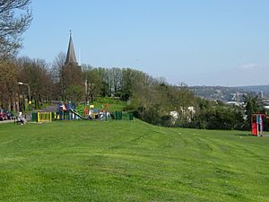
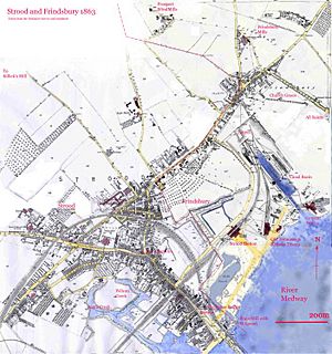
Frindsbury is a town located in Kent, southern England. It's part of the larger Medway Towns area. It sits across the River Medway from Rochester. For a long time, Frindsbury was even considered part of Rochester. Today, Frindsbury is mostly part of Strood, covering its northern areas. The name Frindsbury can mean both a local church area (parish) and a historical estate (manor). The wider area, called Frindsbury Extra, includes villages like Wainscott and Upnor. It was also once an election area (ward) that covered parts of both Frindsbury and Strood.
Contents
Frindsbury's Landscape and Location
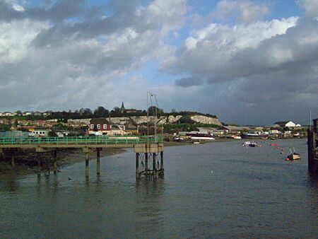
Frindsbury is on the northwest side of the River Medway. This is where the river is narrowest, making it the easiest place to build a bridge. After a small, marshy area near the river, the land quickly rises to a flat area about 30 meters (100 feet) high.
This area was once covered in chalk and a type of soil called brickearth. Over many years, much of this soil and chalk was removed or mined. This changed the shape of the land a lot. A small valley ran through the middle, carrying a stream from the Hoo Peninsula to the Medway.
Even though the land was not very high, the Frindsbury area became a hub for many industries. Near Strood, the marshy coast became quite wide. There's proof that the Romans built a road, Watling Street, across this marsh to bridge the Medway. At that time, Strood was actually part of Frindsbury. The difficult landscape here also affected where railways were built.
Frindsbury's Past: A Look Back in Time
The name Frindsbury comes from an old English word, freondesburh. This means "a stronghold held by a friend or ally." Over the years, its name has been spelled differently, like Freondesbrei (in 764) and Frandesberie (in 1086).
The main church, All Saints, was built on a hill. There was also a smaller church in Strood (St Nicholas'). This was located where the Roman road, Watling Street, left the solid ground to cross the marshes towards the Medway bridge. Strood became its own full parish in 1193.
Ancient Times in Frindsbury
In 1911, the bones of a huge elephant (a type called palaeoloxodon antiquus) were found in Upnor. Later, in 1925, tools from the Palaeolithic (Old Stone Age) were discovered in a quarry near All Saints' Church. These finds included over 4,000 stone tools, like hand axes, dating back about 300,000 years!
More recently, in 2021, new excavations found even more Palaeolithic remains. These included some very large handaxes, one of which was almost 30 cm (12 inches) long. This makes it the third largest handaxe ever found in Britain! These tools show that ancient people lived and worked in this area a very long time ago.
A Bronze Age sword was also found in Upnor. This shows that people lived here during different periods of prehistory.
Some historians believe there was a Roman Villa in Frindsbury. This villa might have grown food for the Roman soldiers stationed in Rochester. In 1819, parts of a Roman road leading from this villa to the bridge were found. Later, in 1888, more Roman items were discovered, including a small bronze statue of Cupid.
Frindsbury in the Middle Ages
In the year 764, King Offa gave land in Frindsbury to the Bishop of Rochester. Later, after wars with the Danes, the land came under the control of Harold Godwinson. After Harold lost the Battle of Hastings, William the Conqueror gave the land to his half-brother, Odo. However, the land was soon returned to the Bishop of Rochester.
The Domesday Book of 1086, a famous survey of England, recorded Frindsbury. It noted that the area had 15 fields for farming, 40 villagers, 28 smallholders, and 9 slaves. There was also a mill, a church, and areas for meadow and woodland. The land was worth much more by 1086 than it had been before the Norman Conquest.
Over the years, there were some disagreements about who owned the church and land in Frindsbury. Eventually, the manor (estate) of Frindsbury stayed with the monks of Rochester until the time of Henry VIII.
There's a fun story about the "Frindsbury Clubs." In 1291, there was a misunderstanding between the monks of Rochester and some local people. The people of Frindsbury, carrying their clubs, had a lively encounter with the monks! As a result, the Frindsbury lads had to walk to the abbey on Whit Monday, carrying their clubs, to ask for forgiveness. This tradition continued for many years. Later, in the 1700s, boys from Frindsbury and Strood would meet each May Day for a friendly competition.
Frindsbury in Modern Times
In 1891, the area of Frindsbury had a population of 5,060 people. In 1894, the parish of Frindsbury was split into two parts: Frindsbury Intra and Frindsbury Extra. Frindsbury Intra became part of Rochester, while Frindsbury Extra joined the Strood Rural District. The rest of Frindsbury Extra also joined Rochester in 1934.
Today, Frindsbury is often called North Strood because it's in the very northern part of the town. Its population is now included in Strood's total of about 40,000 residents. Even though Frindsbury is seen as part of Strood, the parish of Frindsbury Extra is outside Strood's main borders and is part of Rochester. This parish includes villages like Upnor, Wainscott, and Chattenden.
Important Buildings in Frindsbury
The Manor of Frindsbury
The manor house is a historic farmhouse from the late 1500s. In 1753, a new front was added in the Georgian style. The house has a central three-story part with two-story wings on either side. It's also known as Court Lodge Farm.
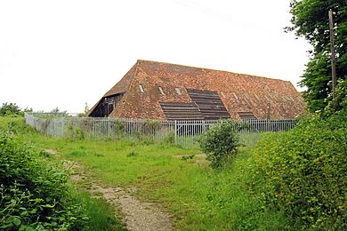
Next to the manor house is a large tithe barn from the early 1400s. This barn is a very important historic building. In 2003, a serious fire destroyed part of the barn. The damaged wood was saved and is stored in the undamaged part. The barn is owned by the Church Commissioners.
Inside the Medieval Barn
Experts originally thought the barn was built around 1300. However, studies in 2002 using tree-ring dating showed that the wood was cut around 1403.
The barn is very well built and was once 65.6 meters (215 feet) long and 10.6 meters (35 feet) wide. It's known for its excellent carpentry. The base of the barn is made of flint and stone. Inside, there are strong wooden frames that support the roof. The roof was probably thatched at first, but now it has clay tiles.
Some parts of the barn have been repaired or changed over time. For example, many of the original doors were blocked up, and new entrances were added. The floor is mostly concrete from the 1800s, likely for housing cattle. Some areas still have earth or chalk floors.
The Church of All Saints
The current All Saints Church was started around 1075. It was rebuilt in 1127, and more work was done in the 1300s and early 1400s. The church was greatly repaired in 1884. Recently, the church has been updated with disabled access, a restroom, and a small kitchen.

Quarry House
Quarry House was first mentioned in 1575. It was a brick house from the early 1600s and was a popular place to visit for its great views. Sadly, it was pulled down in 1897 so that the chalk it stood on could be mined. Drawings of the house were made before it was destroyed.
The Parsonage
In medieval times, a church helped raise money for the Bishop. The Bishop would appoint a priest, called a vicar, to lead services. The Bishop, as the Rector of Frindsbury, would have a large house called a Parsonage. There was a parsonage on Bill Street, which was lived in by the Watson Family in 1591. It was demolished sometime after 1930.
Royal Oak Pub
The Royal Oak pub was first built as a house in the late 1600s. By 1754, it was being used as a public house. It was saved from demolition and was listed as a Grade II historic building in 2016. In 2020, the building was changed into homes.
Frindsbury's Industries
A History of Work
Today, Frindsbury is mainly a residential area for people who work in Rochester. However, it has a rich industrial past. Until 1811, most people in Frindsbury worked in farming. But by 1831, a huge 90% of residents worked in quarrying or manufacturing! This made Frindsbury an industrial hotspot, much more developed than other parts of Kent at the time.
As old industries left the land they had used, new ones moved in. Eventually, many of these industrial sites were turned into housing. The names of the streets in Frindsbury often remember the important families from these industrial times.
Frindsbury Mills
The first recorded windmill in Frindsbury appeared on a map in 1596. It was called the Quarry Mill and was destroyed in 1850.
Later, a man named Mr. Kimmins owned four mills in Frindsbury.
- On Prospect Hill, there were two mills. The "Little Mill" was a black smock mill that ground flour. Next to it was the "Great Mill," which was the tallest in Kent! Together, they produced a lot of flour. The Little Mill was hit by lightning and demolished in 1886, and the Great Mill was taken down in 1890.
- Another mill, Kimmin's Mill, was a smock mill without a base. It was later replaced by a brick field.
- House Mill, also known as Kimmin's Mill or Frindsbury Mill, was another black smock mill on Frindsbury Hill. It was demolished in 1931.
Ship and Barge Building
Frindsbury was also a place where ships and barges were built. You can find more details about this in the main article about Shipbuilding in Frindsbury, Kent.
Thames and Medway Canal
The Thames and Medway Canal also played a role in Frindsbury's industrial past.
Sand Mining
Special molding sand from below Upnor was used to make metal castings. This sand was so good that it was even exported to other places!
Brickfields
In 1847, there were six brickfields in Frindsbury. These were places where clay was dug up to make bricks. The topsoil would be removed, the special clay called brickearth was taken out, and then the topsoil was put back. Sometimes, farms or orchards would then be planted there. One brickfield, Ten Gun Field, produced about 2.5 million bricks every year. In 1844, it made 14 million bricks, which was 1% of all the bricks made in the country!
The bricks made here were "Yellow Stock bricks." They got their color from adding chalk to the clay. The bricks were sorted into different grades based on their quality.
The brick-making business in Frindsbury declined when a new type of clay was found in Peterborough. This clay had natural tar oil, which meant it needed less fuel to bake the bricks. So, the Frindsbury brickyards either went back to farming or were used for new houses.
Cement Works
Portland Cement is a building material made from a mix of chalk and clay. The first place outside the Thames valley to make it was in Frindsbury, in 1851. A man named I. C. Johnson bought an oil mill and turned it into a cement factory, called the Crown Works.
Soon, six more cement factories were built along Limehouse Reach in Frindsbury. All of them used the chalk from the Frindsbury hills and clay from the Medway Estuary.
These cement works included:
- Phoenix Works (started 1877)
- Globe Works (1880)
- Bridge Works (1885)
- Crown Works (1851)
- Quarry Works (1889)
- Beehive Works (1880)
- Beaver Works (1884)
By 1904, these factories were at their busiest. They had 132 kilns (large ovens) and 30 chimneys, making about 4,000 tons of cement each week! They employed 800 people. All these factories started as separate companies but eventually merged. In 1900, a large company called APCM bought them all and renamed the site "Crown and Quarry Works." The works eventually closed in 1963 because most of the chalk on the Frindsbury peninsula had been used up.
Another factory, the Formby Works, was at Whitewall Creek. It produced cement from 1862 and closed in 1909.
Mysterious Holes in the Ground
The hill where Frindsbury stands has many holes. These might be from old mining activities, or they could be natural caves formed by water. Sometimes, these holes have opened up, causing the ground to sink.
Famous Visitors to Frindsbury
In May 1732, the famous artist William Hogarth visited Rochester with his friend, the painter Samuel Scott. They had a fun trip and visited Frindsbury Church. They then walked to Upnor, where Hogarth drew the beautiful and old Upnor Castle. They also explored some old military batteries before heading to Hoo.
In 1783, two engravers, Samuel and Nathaniel Buck, drew a view of Rochester from the top of All Saints' Church Tower.
|
 | Aaron Henry |
 | T. R. M. Howard |
 | Jesse Jackson |


