
Hoo Peninsula facts for kids
Quick facts for kids Hoo Peninsula |
|
|---|---|
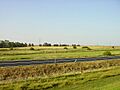
 Stoke Marshes, Hoo Peninsula |
|

Hoo Peninsula
|
|
| Population | 31,050 |
| OS grid reference | TQ7675 |
| Unitary authority | |
| Ceremonial county | |
| Region | |
| Country | England |
| Sovereign state | United Kingdom |
| Post town | ROCHESTER |
| Postcode district | ME3 |
| Dialling code | 01634 |
| Police | Kent |
| Fire | Kent |
| Ambulance | South East Coast |
| EU Parliament | South East England |
| UK Parliament |
|

The Hoo Peninsula is a piece of land in Kent, England. It has water on three sides, separating the wide river mouths (estuaries) of the Thames and Medway. The peninsula has a line of sand and clay hills. These hills are surrounded by large areas of marshland, which is made of mud and soil.
The name Hoo is an old Saxon word. It probably means 'spur of land' or refers to the 'heel-shape of the hills' near Hoo. The area is even mentioned in the Domesday Book, a famous survey from 1086. Today, the Hoo Peninsula is important for wildlife, with many protected sites. It also has big industrial areas and energy plants.
Contents
History of the Hoo Peninsula
The Romans were the first to try building sea walls here. These walls helped drain the marshes, turning them into good land for sheep to graze.
This area is full of interesting old finds. People have found tools from the Bronze Age and burial sites from the Jutes. Roman pottery has also been discovered at Cooling. Long ago, this was a place where people could cross the River Thames to Essex by walking through a shallow part of the river.
Much of the peninsula was part of an old Saxon area called a "hundred." This specific area was known as the "Hundred of Hoo." It included the villages and churches of Hoo, High Halstow, St Mary Hoo, Allhallows, and part of Stoke.
After the Norman Conquest, William the Conqueror gave the large estate of Hoo to his half-brother, Odo.
During the First World War, the peninsula was used for an explosives factory. It also had a place to store explosives.
Geography and Nature
The Marshes: Home to Wildlife
The marshlands on the Hoo Peninsula are part of the wider North Kent Marshes. They are now important protected areas. These include the Thames Estuary and Marshlands, and the Medway Estuary and Marshes.
The Thames Estuary area stretches about 24 kilometers (15 miles) from Gravesend to the Isle of Grain. The Medway Area covers about 24 kilometers (15 miles) from Rochester to the Isle of Grain. Together, these marshlands cover about 98 square kilometers (38 square miles).
Both areas are special places called Sites of Special Scientific Interest (SSSI) and Special Protected Areas (SPA). They include coastal grazing marsh, muddy areas exposed at low tide, saltmarsh, and lagoons. There is also a nature reserve called Northward Hill National Nature Reserve on the line of hills.
High Halstow National Nature Reserve
The Hoo Peninsula is home to a 129.7-acre nature reserve. It is located in High Halstow, one of the villages on the peninsula. This reserve is called High Halstow NNR.
It is also part of a larger site managed by the Royal Society for the Protection of Birds. This site includes 270 hectares of grazing marsh, woodland, and farmland. The area is famous for having the largest heronry (a place where herons nest) in Britain. About 150 to 200 pairs of herons nest here. People have known about the heronry in these woods since at least 1947. High Halstow NNR was officially made a National Nature Reserve in 1951.
The Thames and Medway Canal
The Rivers Thames and Medway were once connected by the 8-mile (13 km) long Thames & Medway Canal. Building started in 1805. The canal had ports at Gravesend and Strood. It also passed through a 2-mile (3.2 km) tunnel at Higham. This tunnel had a shaft in the middle for boats to pass through.
Building the canal was hard and costly. It was not finished until 1824. Soon after, the tunnel became part of the railway line connecting Higham with Strood. The path of this canal, which is now filled with mud, can be seen as the edge of the peninsula on the land side.
The tunnel goes through large areas of chalk. To save money, many parts were not lined. This caused rocks to fall between 1957 and 2004. Because these rock falls could cause trains to crash, the tunnel was closed in 2004. It was then relined with strong concrete. The tunnel reopened in early January 2005.
Roads Connecting the Peninsula
The main road on the peninsula is the A228. It crosses the old Roman London Road (also called Watling Street, now the A2) at Strood. Then, it follows the high ground towards the east. This road meets the Medway Towns Northern Bypass (A289) at the bottom of Four Elms Hill. It then climbs to Chattenden, going around Hoo St Werburgh and High Halstow. Finally, it crosses to the Isle of Grain. On the peninsula, this road is known as the 'Ratcliffe Highway'.
Another important road is the B2000. It goes north to Cliffe, near the Cliffe marshes. This is a winding country road. It is used a lot by trucks serving the big farms and industrial jetties on the River Thames. The B2000 goes through Cliffe Woods as 'Town Road'. It then enters Cliffe, where it becomes 'Station Road' (named after a vanished railway station). After that, it becomes 'Church Street'. At the north end of the village, the road turns into 'Pond Hill'. This leads down a cliff to a dirt track on the marshes.
The B2000 is a rural road with several interesting old buildings. There is a Grade II listed red brick farmhouse from the 17th century called 'Mockbeggar Farm'. Its barn is also listed. Another listed building is 'Mortimer's Farm House' in Cliffe.
Fenn Street Farmhouse is also Grade II-listed. It is timber-framed and very old, with parts dating back to the 15th century. It was even refaced in 1760.
There are many other smaller roads on the higher ground. Also, there are roads and tracks across the marshes. Some of these eventually reach the sea walls.
The Hundred of Hoo Railway


In 1878, local farmers asked the South Eastern Railway Company for a new railway. From this meeting, the Hundred of Hoo Railway Company was started. The railway company saw it as a way to develop travel to other countries. A ferry terminal was built at Port Victoria as the end of the line. However, not many people used the ferry. That part of the line and the line beyond Grain closed in 1951.
The first part of the railway opened in March 1882, from Cliffe to Sharnal Street. This was later extended east to the Isle of Grain. Sharnal Street was the bigger of the two first stations. It had special tracks for goods. Farmers could load their produce here to send directly to London markets. Telegrams and mail were also collected at Sharnal Street.
On May 14, 1932, a branch railway line opened to the Thames estuary near the old village of Allhallows. The idea was to create a large riverside resort there. Big plans were made, and the new area was called Allhallows-on-Sea. However, not much came of the plan. Today, all signs of that branch line are gone. Only the water tower that supplied water to the trains remains. It is now a listed building. A holiday village is now on the site where the resort was planned.
Industries on the Peninsula
The Hoo Peninsula's location is very good for industry. It has been home to many large industries that need a lot of space. These include power stations, oil storage areas, oil refineries, gas plants, and explosive factories. There is also a container terminal and places where minerals are dug up.
Many of these are on the Isle of Grain. Others are, or were, located at Kingsnorth on the south side of the peninsula, up the River Medway from Grain. Some were also at Cliffe at the western end of the peninsula.
Energy Industries
Many industrial sites on the Hoo Peninsula are linked to energy. This includes oil, gas, and electricity. There have been five power stations here: Grain, Grain CCGT, Kingsnorth, Medway, and Damhead Creek. There were also four oil refineries and three oil storage tank farms. Two gas plants (Grain LNG) and a power cable from the Netherlands (BritNed) are also here.
The oil industry started on the Hoo Peninsula in 1908. The Admiralty (the navy's department) built an oil storage and ship refuelling depot at the Isle of Grain. This was because the Royal Navy wanted oil-fired ships, which were faster and produced less smoke. By 1912, there were 19 oil tanks and two jetties (piers) in the deep water of the Medway. These tanks were used until the 1950s and then became part of the BP refinery.
In 1923, the Medway Oil and Storage Company (MOSCO) built an oil refinery and tank farm near the Admiralty site. This site was 53.4 hectares (132 acres). It had four groups of oil tanks and two short jetties in the Medway. Crude oil came from Russia and was refined here. The petrol was sold as 'Power Petrol'. In 1925, there was an oil tank explosion that killed three workers. MOSCO later became part of the Anglo-Iranian group (which became BP) in 1932. After this, oil refining at Grain stopped. The MOSCO site was joined with the BP refinery in 1952.
In 1924, Berry Wiggins and Company built a plant at Sharnal Street to make bitumen (a sticky black substance used in roads). In 1930, Berry Wiggins started building an oil refinery and tank farm at Kingsnorth. At first, they used a wharf at Damhead Creek. But in 1937, they built the 2.5 km (1.5 mile) Bee Ness Jetty into the River Medway for larger oil tankers. This was said to be the longest jetty in Britain. Oil was moved from the jetty to the refinery through pipes. The old Berry Wiggins Kingsnorth refinery closed in 1977.
Construction of the BP Refinery (Kent), also known as Grain Refinery, began in 1950 and opened in 1952. It could process four million tonnes of oil per year. By 1964, its capacity had grown to 9,500 tonnes per year. The refinery started processing North Sea crude oil in 1975. The BP Kent refinery closed in 1982. After that, British Gas took over some of the site for a liquefied natural gas facility.
In 1957, the South Eastern Gas Board (SEGAS) built a plant next to the BP Refinery. It used light oil products from the refinery to make town gas. This plant was no longer needed when Britain switched from town gas to natural gas between 1967 and 1977.
The 2,000 MW Kingsnorth power station opened in 1967. It burned coal or oil, depending on which was cheaper. Building it was difficult because the reclaimed marshland was not strong enough to hold heavy structures. Kingsnorth's ground level was also below the highest tide. However, it was close to London, had cooling water from the River Medway, and deep water for oil tankers.
Between 1971 and 1981, the Burmah-Total oil company planned to build an oil refinery on Cliffe marshes. But oil crises in the 1970s made the project too expensive, so the plans were dropped.
Grain oil-fired power station was built on a 100-hectare site. It started working in 1979 and was planned to produce 3,300 MW of power. The power station closed in 2015 and was later taken down.
Medway Power Station is a 735-megawatt gas-fired power station on the Isle of Grain. It is next to the River Medway and started operating in 1995.
Damhead Creek is a 792 MWe gas-fired power station. It uses a Combined Cycle Gas Turbine (CCGT) system and started working in 2001.
Grain LNG Terminal is a facility for importing, storing, and exporting liquefied natural gas (LNG). It was built from 2002 onwards and is now a major part of Britain's gas supply.
Grain CCGT power station is a 1,275 MW plant. It has three natural gas-fired Combined Cycle Gas Turbine units. It started operating in May 2010 and cost £580 million. This power station can also send heat energy to the nearby LNG terminal.
BritNed is a special high-voltage direct-current (HVDC) submarine power cable. It runs under the sea between the Isle of Grain in Kent, UK, and Maasvlakte in Rotterdam, the Netherlands. It started working in 2011.
Other Industries on the Peninsula
Other industries on the Hoo Peninsula include an explosives factory at Cliffe. This was started in 1900 by Curtis and Harvey Limited. It was on a 128-hectare site near Lower Hope Point. It made nitroglycerine, cordite, dynamite, and guncotton. The site grew during the early 1900s and was one of the largest in the country by 1908. It expanded even more during the First World War but closed in 1921. You can still see the foundations of the buildings in the landscape.
A cement works was built at Cliffe around 1860, using chalk from the local area. The Alpha Cement works started in 1910 and operated in different forms until 1970. Today, the site is used to import, store, and load aggregates (materials like sand and gravel). Aggregates are unloaded at two jetties on the River Thames near Cliffe fort. They are then moved by a 1.7 km conveyor belt to the main site. Here, railway wagons are loaded. The site is currently run by Brett Aggregates Limited.
In 1960, BP and California Chemicals built a petrochemical plant. This plant made synthetic fibres from oil by-products.
London Thamesport is a small container seaport in the Port of London. It is on the River Medway, located on the Isle of Grain. It was first developed as a container port in 1989. It was then made into a deep-water port starting in 2001.
Villages on the Hoo Peninsula
- Allhallows
- Chattenden
- Cliffe
- Cliffe Woods
- Cooling
- Frindsbury
- Grain
- High Halstow
- Hoo St Werburgh
- St Mary Hoo
- Spendiff
- Stoke
- Upnor
- Wainscott
Images for kids
-
Stoke Marshes, Hoo Peninsula
