
Geography of Romania facts for kids
Romania is a country in southeastern Europe. It's the second largest country in this part of Europe, covering about 238,391 square kilometers. It's also the twelfth-largest country in all of Europe. A big part of Romania's border with Serbia and Bulgaria is formed by the Danube River. The Prut River joins the Danube and forms the border with the Republic of Moldova. The Danube then flows into the Black Sea within Romania, creating the Danube Delta. This delta is one of the best-preserved deltas in Europe. It's also a special biosphere reserve and a biodiversity World Heritage Site. Other important rivers in Romania include the Siret River, which flows from north to south in Moldavia; the Olt River, which starts in the Carpathian Mountains and flows through Oltenia; and the Mureş River, which crosses Transylvania from east to west.
Contents
Romania's Landscape
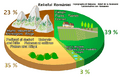
Romania's land is split pretty evenly between mountains, hills, and flat areas. The Carpathian Mountains cover a large part of central Romania. There are 14 mountain ranges in Romania that are taller than 2,000 meters (about 6,560 feet). The highest mountain in Romania is Moldoveanu Peak, which is 2,544 meters (about 8,346 feet) tall.
Waterways of Romania
Rivers
The Danube River is the longest river in Romania. It flows for about 1,075 kilometers (about 668 miles) through the country, which is almost 40% of its total length. Most of Romania's rivers either flow directly into the Danube or into other rivers that eventually join the Danube. Some of the most important rivers that flow into the Danube are the Mureş River, the Olt River, the Prut River, the Siret River, the Ialomiţa River, the Someş River, and the Argeș River.
The rivers in Romania flow outwards from the Carpathian Mountains in different directions: north, south, east, or west. Rain and snow help keep the rivers full, but sometimes they can cause flooding. In the east, rivers flow into the Siret River and Prut River. In the south, rivers flow straight into the Danube. In the west, rivers flow into the Tisza River, which is in Hungary.
The Danube is very important for Romania. People use it for transportation and to create hydroelectric power. Boats and other watercraft can travel on most parts of the Danube in Romania. One challenge is that the river isn't very close to Romania's biggest industries, which can make transportation a bit harder.
Lakes
Where is Romania Located?
Romania is located in the southeastern part of Europe. It shares a border with the Black Sea and the Danube River. The Carpathian Mountains are found in the center of the country.
Geographic coordinates: 46°00′N 25°00′E
Here are the extreme points of Romania:
- Northernmost point: Horodiştea, a village in Botoşani County, on the border with Ukraine. 48°15′N 26°42′E
- Southernmost point: Zimnicea, a town in Teleorman County, on the border with Bulgaria. 43°37′N 25°23′E
- Westernmost point: Beba Veche, a village in Timiş County, on the border with Hungary and Serbia. 46°07′N 20°15′E
- Easternmost point: Sulina, a town in Tulcea County, on the Danube Delta. 45°09′N 29°41′E
Land Borders
Romania has a total land border length of 3,149.9 kilometers (about 1,957 miles). It shares borders with these countries:
Romania's Climate
Romania is located far from the open ocean and in the southwestern part of Europe. Because of this, it has a climate that changes between a temperate and continental climate. This means it experiences four distinct seasons: spring, summer, autumn, and winter.
The average temperature for the whole year is about 11°C (52°F) in the south and 8°C (46°F) in the north. The highest temperature ever recorded in Romania was 44.5°C (112.1°F) in Ion Sion in 1951. The lowest temperature ever recorded was -38.5°C (-37.3°F) in Bod in 1942.
Rain, snow, and other precipitation are quite common, with over 750 millimeters (about 30 inches) falling each year on the highest western mountains. Most of this precipitation comes as snow, which makes Romania a good place for skiing. In the south-central parts of the country, the amount of rain and snow drops to around 600 millimeters (about 24 inches). The Danube Delta receives the least amount of rain.
Related pages
Images for kids
-
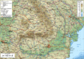
A general map of Romania
-
Natural landscape of Romania
-
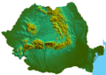
Physical map of Romania showing the Carpathian Mountains
-
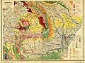
Geology of Romania and neighbours
-
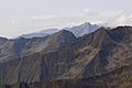
The Făgăraș Mountains are the tallest in Romania
-
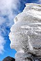
The Romanian Sphinx is a natural rock formation on the plateau of Bucegi Mountains at 2,216 m (7,270 ft) altitude. It measures 8 meters (26 ft) in height and 12 meters (39 ft) in width.
-
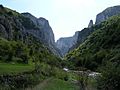
Cheile Turzii and Hășdate River in Transylvania.
-
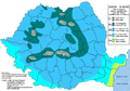
Romania map of Köppen climate classification, according with Clima României from the Administrația Națională de Meteorologie, Bucharest 2008
-

Turda salt mine
-
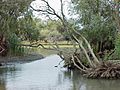
Landscape in the Danube Delta


.jpg)


See also
 In Spanish: Geografía de Rumania para niños
