
Grant's Canal facts for kids

Grant's Canal, also called Williams's Canal, was a project during the American Civil War. It was an attempt to dig a canal for military ships. The canal was planned to go through De Soto Point in Louisiana. This area was right across the Mississippi River from Vicksburg, Mississippi.
In 1862, the Union Navy tried to capture Vicksburg. But they couldn't do it with just army support. Union Brigadier General Thomas Williams was sent to De Soto Point. He had 3,200 men with him. Their job was to dig a canal. This canal would let Union ships bypass the strong Confederate defenses around Vicksburg.
Local plantation slaves helped with the digging. But many workers got sick. Also, the river levels dropped too low. These problems stopped Williams from finishing the canal. The project was put on hold.
In January 1863, Union Major General Ulysses S. Grant became interested in the canal. He tried to fix the earlier problems. Grant moved the canal's upstream entrance to a place with a stronger current. But heavy rains and floods broke a dam. This stopped the project again.
Grant eventually used other ways to capture Vicksburg. The Confederate soldiers there gave up on July 4, 1863. Later, in 1876, the Mississippi River changed its path. It cut across De Soto Point. This change actually separated Vicksburg from the main river. But in 1903, the Yazoo Diversion Canal was finished. This brought Vicksburg back to the river.
Most of the original canal site is now gone due to farming. But a small part of it still exists. Local landowners gave this section to the National Park Service. In 1990, it became part of Vicksburg National Military Park. A study in 1974 suggested the canal might have worked. This would have happened if a dam at the canal's lower end had been opened.
Contents
History of Grant's Canal
Why the Canal Was Needed
At the start of the American Civil War in 1861, General Winfield Scott of the United States Army created a plan. It was called the Anaconda Plan. A big part of this plan was to control the entire Mississippi River.
In early 1862, the Union Army won many important battles. These included Shiloh and Fort Donelson. The city of New Orleans, Louisiana also fell to Union troops in April. After these wins, much of the Mississippi Valley was controlled by the Union.
Flag Officer David Farragut led the Union Navy ships that took New Orleans. He then sailed his ships upriver to Vicksburg, Mississippi. Vicksburg was very important because it controlled a key part of the river. In May, Farragut asked Vicksburg to surrender, but they refused. Union ships then fired on Vicksburg several times. But Farragut decided to pull back to New Orleans. Many people thought this was a bad decision.
Another attempt to take Vicksburg happened in June. This time, Union Brigadier General Thomas Williams brought 3,200 soldiers. This was almost three times more men than before. Williams's soldiers, Farragut's navy ships, and ships with mortars led by Commodore David Dixon Porter left Baton Rouge, Louisiana, on June 20. They reached Vicksburg five days later.
On June 26, Porter and Farragut's ships tried to bomb the Confederate artillery defenses. But they couldn't make the city surrender. Two days later, Farragut ordered most of his ships to sail past the city's defenses. They were going to meet Union ironclads coming from Memphis, Tennessee. Farragut's ships had to go around De Soto Point. This was a bend in the Mississippi River in Louisiana. The Union ships were damaged, but they made it past the defenses.
Both Farragut and the ironclad commander, Flag Officer Charles Davis, agreed. They knew the navy couldn't capture Vicksburg without a lot of army troops. And the Union leaders wouldn't send enough soldiers for the Vicksburg attacks.
The 1862 Canal Project

After realizing they needed more help, a canal project became very important. On June 27, Williams's men started digging a canal across De Soto Point. Local plantation slaves also helped. They believed they would be set free for their work. However, Williams only planned to free them if the canal was finished.
The canal was planned to be about 6 miles (9.7 km) long. It would open into the river both above and below Vicksburg. It was meant to be 50 feet (15 m) wide. If it worked, Union ships could use the canal. This would let them avoid the Confederate guns at Vicksburg. It was also hoped the river might change its course. This would leave Vicksburg completely cut off from the river.
Around 1,200 to 1,500 African Americans worked on the project. But progress was slow. The river level kept falling. Also, many workers got sick. The temperature sometimes reached 110 °F (43 °C). Clean drinking water was hard to find. The swamps were full of mosquitoes. One Union doctor said the swamps had "as much death to the square inch" as possible.
Diseases like Malaria, dysentery, and scurvy were common. Medicine like quinine ran out. Soldiers also dumped raw sewage into the Mississippi River. This was also their source of drinking water, which made the disease problem worse.
Engineers thought the ground was mostly clay, about 11 feet (3.4 m) deep. Below that was sand. They believed a river current would cut through sand, but not clay. So, all the clay had to be removed before the canal opened to the river. (Later, it was found that clay can also wear away.)
By July 4, 1862, the canal was only about 7 feet (2.1 m) deep. A week later, it was 1.5 feet (0.46 m) below the river's surface. By July 17, the canal was 13 feet (4.0 m) deep and 18 feet (5.5 m) wide. But the Mississippi River's level had dropped even lower than the canal.
As conditions worsened, Williams decided the canal couldn't be finished. His force was down to only 800 healthy men because of disease. Williams ordered his men to leave De Soto Point. The canal work stopped on July 24. With the soldiers gone, Flag Officer Davis moved his ironclads upriver to Helena, Arkansas.
Later, Confederate soldiers checked the canal area. They found 600 graves and 500 abandoned African Americans. The canal had reached 13 feet (4.0 m) deep and 18 feet (5.5 m) wide. But these sizes were not enough for ships to use.
The 1863 Canal Project

Even though a Vicksburg newspaper editor asked for it, Confederate troops never filled in the canal. In January 1863, the Mississippi River level started to rise. Union Major General Ulysses S. Grant decided to try the canal plan again.
The steamboat Catahoula was sent to check the canal. Both the captain and a reporter on board said there was water in the canal. But it was still water, with no current. They reported that a lot more work was needed for large ships to pass through.
After making some changes to the plans, Grant ordered digging to start again. Union officers who visited later found the water was only 2 feet (0.61 m) deep in the ditch. They also noted there was no current. However, some parts were reported to be up to 8 feet (2.4 m) deep and 12 feet (3.7 m) wide.
President Abraham Lincoln supported the project. Captain F. E. Prime, an engineer, was put in charge. Early attempts didn't make much progress. So, Grant ordered the upstream end of the canal to be moved. This was to a spot where a stronger current could flow into the ditch.
The canal was also made wider. But because there was water in the canal, the newly widened parts were only as deep as the water level. By the end of the month, Grant started to doubt the canal would work. But he kept the construction going.
More outbreaks of disease happened. The walls around the project often broke, flooding parts of the canal. The diggers were also shot at by Confederate artillery. By this time, the construction was divided into 160-foot (49 m) sections. Each section was meant to be 6 feet (1.8 m) deep and 60 feet (18 m) wide.
In February, dredging boats arrived from Louisville, Kentucky. This sped up the work. But heavy rains caused problems. They uncovered poorly buried graves from the Battle of Chickasaw Bayou. The rain also turned the soil into a muddy mess. Union Major General William T. Sherman described it as "wet, almost water."
Union newspapers criticized the project. The Confederates built new artillery batteries. These guns could fire along the entire length of most of the canal. On March 7, the dam holding the upstream end of the canal broke. This flooded the canal. The break in the dam couldn't be fixed. The canal then started to fill with mud and dirt.
Two large dredging boats, Hercules and Sampson, tried to clear the channel. But Confederate artillery fire drove them away. The canal had reached a width of about 60 feet (18 m). Its depth was about 9 feet (2.7 m) to 12 feet (3.7 m). A 1974 article in The Military Engineer suggested something interesting. If the dam at the lower end of the canal had also been opened, a strong current might have formed. This current could have successfully carved out the canal.
Grant saw the canal work as a way to keep his soldiers busy. But he eventually found another way to move his troops past Vicksburg.
What Happened Next
In April, Grant decided to land troops on the Mississippi side of the river below Vicksburg. By mid-May, Grant's men had fought their way to Vicksburg. They then started a siege of the city. The Siege of Vicksburg lasted until the Confederate defenders surrendered on July 4.
After Vicksburg surrendered, the Confederate soldiers at Port Hudson, Louisiana, also gave up. This gave the Union full control of the Mississippi River.
In April 1876, the Mississippi River changed its path. It cut through De Soto Point. This eventually separated Vicksburg from the riverfront. An oxbow lake formed where the old river path was. Vicksburg didn't have direct river access again until 1903. That's when the Yazoo Diversion Canal was completed.
Most of the original canal path has been destroyed by farming. But a small section still remains. The landowners gave this part to the National Park Service. It was added to Vicksburg National Military Park in 1990. At the site, there is also a memorial for the Union African American soldiers. They fought at the battles of Milliken's Bend and Goodrich's Landing. A monument to the 9th Connecticut Infantry Regiment was also placed there in 2008. This National Park Service site is in Madison Parish, Louisiana.
Sources
- Bastian, David Fenwick (July-August 1974). "Hydraulic Analysis of Grant's Canal". The Military Engineer 66 (432): 228–229. https://www.jstor.org/stable/44558356. Retrieved 3 January 2021.
- Carter, Samuel (1980). The Final Fortress: The Campaign for Vicksburg 1862–1863. New York, New York: St. Martin's Press. ISBN 978-0-3128-3926-0.
- Kennedy, Frances H., ed. (1998). The Civil War Battlefield Guide (2nd ed.). Boston/New York: Houghton Mifflin. ISBN 978-0-395-74012-5.
Images for kids
-
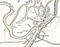
Map of the Vicksburg area, De Soto Point, and the canal. The positions to the north of Vicksburg are related to the Battle of Chickasaw Bayou.
-
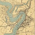
Map of the Vicksburg defenses and De Soto Point. The lines show where Confederate guns could fire.
-

A drawing of Grant's Canal being dug, published in Frank Leslie's Illustrated Newspaper (1863).

_(cropped).jpg)
.jpg)
