Pitt County, North Carolina facts for kids
Quick facts for kids
Pitt County
|
|||||
|---|---|---|---|---|---|

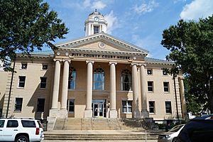
Pitt County Courthouse in Greenville
|
|||||
|
|||||

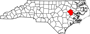
Location within the U.S. state of North Carolina
|
|||||
 North Carolina's location within the U.S. |
|||||
| Country | |||||
| State | |||||
| Founded | 1760 | ||||
| Named for | William Pitt the Elder | ||||
| Seat | Greenville | ||||
| Largest community | Greenville | ||||
| Area | |||||
| • Total | 655.55 sq mi (1,697.9 km2) | ||||
| • Land | 652.37 sq mi (1,689.6 km2) | ||||
| • Water | 3.18 sq mi (8.2 km2) 0.49% | ||||
| Population
(2020)
|
|||||
| • Total | 170,243 | ||||
| • Estimate
(2023)
|
175,119 | ||||
| • Density | 260.96/sq mi (100.76/km2) | ||||
| Time zone | UTC−5 (Eastern) | ||||
| • Summer (DST) | UTC−4 (EDT) | ||||
| Congressional districts | 1st, 3rd | ||||
Pitt County is a county in the Inner Banks area of North Carolina. It's located in the eastern part of the state. In 2020, about 170,243 people lived here. This makes it the 14th most populated county in North Carolina.
The main city and county seat is Greenville. Pitt County is part of the larger Greenville, NC Metropolitan area.
Contents
Discovering Pitt County's History
Pitt County was created in 1760 from Beaufort County. The new county officially started on January 1, 1761. It was named after William Pitt the Elder. He was an important English leader and speaker.
William Pitt was born in London, England. He studied at Oxford University and joined the army in 1731. He became a secretary of state in 1756. Pitt spoke up for freedom in the British Colonial government. He also served as the Prime Minister of Great Britain from 1766 to 1768.
Many people moved to Pitt County between 1980 and 2010. The population grew a lot during these years.
Exploring Pitt County's Geography
Pitt County covers about 655.55 square miles. Most of this area, about 652.37 square miles, is land. The rest, about 3.18 square miles, is water.
Protected Natural Areas
- North Carolina Museum of Natural Science Contentnea Creek
- North Carolina Museum of Natural Science Greenville
Major Rivers and Creeks
- Contentnea Creek
- Creeping Swamp
- Fork Creek
- Middle River
- Neuse River
- Swift Creek
- Tar River
- Tranters Creek
Neighboring Counties
Pitt County shares borders with several other counties:
- Martin County – to the northeast
- Beaufort County – to the east
- Craven County – to the south-southeast
- Lenoir County – to the south-southwest
- Greene County – to the southwest
- Wilson County – to the west
- Edgecombe County – to the northwest
Important Roads and Highways
 I-587
I-587 US 13
US 13
 US 64 Alt.
 US 258
 US 264


 US 264 Alt.
 NC 11
NC 11
 NC 11 Bus.
 NC 11 Byp.
 NC 30
NC 30 NC 33
NC 33 NC 43
NC 43 NC 102
 NC 118
 NC 121
 NC 222
 NC 903
Key Transportation Hubs
- G.K. Butterfield Transportation Center
- Pitt-Greenville Airport
Population and People
| Historical population | |||
|---|---|---|---|
| Census | Pop. | %± | |
| 1790 | 8,270 | — | |
| 1800 | 9,084 | 9.8% | |
| 1810 | 9,169 | 0.9% | |
| 1820 | 10,001 | 9.1% | |
| 1830 | 12,093 | 20.9% | |
| 1840 | 11,806 | −2.4% | |
| 1850 | 13,397 | 13.5% | |
| 1860 | 16,080 | 20.0% | |
| 1870 | 17,276 | 7.4% | |
| 1880 | 21,794 | 26.2% | |
| 1890 | 25,519 | 17.1% | |
| 1900 | 30,889 | 21.0% | |
| 1910 | 36,340 | 17.6% | |
| 1920 | 45,569 | 25.4% | |
| 1930 | 54,466 | 19.5% | |
| 1940 | 61,244 | 12.4% | |
| 1950 | 63,789 | 4.2% | |
| 1960 | 69,942 | 9.6% | |
| 1970 | 73,900 | 5.7% | |
| 1980 | 90,146 | 22.0% | |
| 1990 | 107,924 | 19.7% | |
| 2000 | 133,798 | 24.0% | |
| 2010 | 168,148 | 25.7% | |
| 2020 | 170,243 | 1.2% | |
| 2023 (est.) | 175,119 | 4.1% | |
| U.S. Decennial Census 1790–1960 1900–1990 1990–2000 2010 2020 |
|||
2020 Census Information
In 2020, Pitt County had 170,243 residents. There were 70,926 households and 41,427 families. The population includes people from many different backgrounds.
| Race | Number | Percentage |
|---|---|---|
| White (non-Hispanic) | 86,837 | 51.01% |
| Black or African American (non-Hispanic) | 59,813 | 35.13% |
| Native American | 494 | 0.29% |
| Asian | 3,056 | 1.8% |
| Pacific Islander | 94 | 0.06% |
| Other/Mixed | 6,981 | 4.1% |
| Hispanic or Latino | 12,968 | 7.62% |
Education in Pitt County
Pitt County offers many choices for schooling.
Private Schools
Here are some private schools in Pitt County:
- Brookhaven SDA School
- Calvary Christian Academy
- Children's Montessori School
- Christ Covenant School
- Community Christian Academy
- Faith Christian Academy
- Greenville Christian Academy
- Greenville Montessori School
- John Paul II Catholic HS
- The Oakwood School
- Roseleaf Academy
- Saint Peter Catholic School
- Trinity Christian School
Public Schools
Pitt County Schools manages all public schools in the county.
Elementary Schools
- Ayden Elementary School
- Belvoir Elementary School
- Creekside Elementary School
- Eastern Elementary School
- Elmhurst Elementary School
- Falkland Elementary School
- H. B. Sugg School (Kindergarten–2nd grade)
- Lake Forest Elementary School
- Northwest Elementary School
- Ridgewood Elementary School
- Sam D. Bundy School (3rd–5th grade)
- South Greenville Elementary School
- W. H. Robinson Elementary School
- Wahl-Coates Elementary School
- Wintergreen Intermediate School (3rd–5th grade)
- Wintergreen Primary School (Kindergarten–2nd grade)
K–8 Schools
These schools teach students from kindergarten through 8th grade:
- Bethel School
- Chicod School
- G. R. Whitfield School
- Grifton School
- Pactolus School
- Stokes School
Middle Schools
- A. G. Cox Middle School
- Ayden Middle School
- C. M. Eppes Middle School
- E. B. Aycock Middle School
- Farmville Middle School
- Hope Middle School
- Wellcome Middle School
High Schools
- Ayden-Grifton High School
- D. H. Conley High School
- Farmville Central High School
- J. H. Rose High School
- North Pitt High School
- South Central High School
Alternative Schools
- Pitt County Schools Early College High School
Colleges and Universities
- East Carolina University
- Pitt Community College
- Miller-Motte Technical College
Communities of Pitt County
Cities
- Greenville (This is the county seat and the largest community.)
Towns
Census-Designated Places
These are areas that are like towns but are not officially incorporated:
Unincorporated Communities
These are smaller communities without their own local government:
- Bell's Fork
- Black Jack
- Chicod
- House
- Pactolus
- Oakley
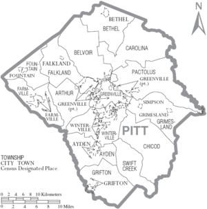
Townships
Townships are smaller divisions within the county, often used for administrative purposes.
- Arthur
- Ayden
- Belvoir
- Bethel
- Black Jack
- Carolina
- Chicod
- Falkland
- Farmville
- Fountain
- Greenville
- Grifton
- Grimesland
- Pactolus
- Simpson
- Swift Creek
- Winterville
See also
 In Spanish: Condado de Pitt para niños


