
Gundagai facts for kids
Quick facts for kids GundagaiNew South Wales |
|||||||||||||||
|---|---|---|---|---|---|---|---|---|---|---|---|---|---|---|---|

Sheridan Street in 2019
|
|||||||||||||||

Gundagai
Location in New South Wales
|
|||||||||||||||
| Population | 2,057 (2021 census) | ||||||||||||||
| Established | 1838 | ||||||||||||||
| Postcode(s) | 2722 | ||||||||||||||
| Elevation | 232 m (761 ft) | ||||||||||||||
| Location |
|
||||||||||||||
| LGA(s) | Cootamundra-Gundagai Regional Council | ||||||||||||||
| County | Clarendon | ||||||||||||||
| State electorate(s) | Cootamundra | ||||||||||||||
| Federal Division(s) | Riverina | ||||||||||||||
|
|||||||||||||||
|
|||||||||||||||
Gundagai is a town in New South Wales, Australia. Even though it's a small town, Gundagai is famous in stories and songs. It's often seen as a great example of a typical Australian country town.
Gundagai is located by the Murrumbidgee River. It's about 390 kilometers (242 miles) southwest of Sydney. In 2021, about 2,057 people lived in Gundagai.
Contents
Discovering Gundagai's Past
The land around Gundagai has always been important to the Wiradjuri people. They are the traditional owners of this area. The floodplains of the Murrumbidgee River were a common meeting place for them.
Plans to create the town of Gundagai began in 1838. It was advertised as "Gundagae on the Murrumbidgee," about 54 miles past Yass.
Early Explorers and Settlers
In November 1824, explorers Hamilton Hume and William Hovell passed through the region. They saw trees that had already been marked by steel tools. This suggested that people had been there before them.
In 1838, the town was officially recognized. Early settlers found a wonderful place to live. One local settler, 'Warby', followed Hume and Hovell's tracks. He set up a large farm called 'Minghee', which was later known as 'Mingay'.
Charles Sturt also traveled through Gundagai in 1829. He was looking for an inland sea. He found several settlers already living in the area. These settlers were living beyond the official "limits of location" for new towns.
In 1836, William Adams Brodribb moved to the area. He helped set up a cattle station. He also asked for a ferry service across the Murrumbidgee River near his home. Officials agreed it was a perfect spot for a new town.
Lady Jane Franklin, the wife of Tasmania's governor, visited Gundagai in 1839. She noted a store and pub with a "neat verandah."
Edward John Eyre, another explorer, passed through Gundagai in 1838. He was moving livestock to Adelaide. He crossed the river twice to find better water and food for his animals.
In 1832, Caroline McAlister gave birth to a son named John. He might have been one of the first European children born in the Gundagai area.

Important People from Gundagai
In the 1830s, the Wills family lived near Gundagai. Their son, Tom Wills, was born here. He is famous for helping to create Australian Rules Football. He also coached the first Australian Aboriginal cricket team.
Two important Aboriginal Elders from Gundagai, Jimmy Clements and John Noble, attended a special event in 1927. They went to the opening of the new Parliament House in Canberra. They met the Duke and Duchess of York, who later became King George VI and Queen Elizabeth.
Gundagai's Post Office and Railway
The Gundagai Post Office first opened on April 1, 1843. This happened as the town grew.

The railway line reached Gundagai in 1886. It connected Gundagai to Cootamundra. The line was later extended to Tumut and then to Batlow and Kunama. However, after being damaged by floods in 1984, the railway line was closed.
Major Floods in Gundagai
The first European town of Gundagai was built on the Murrumbidgee River floodplain. This made it very vulnerable to floods.
In 1844, a big flood hit the town. Local Aboriginal people were heroes, rescuing many settlers. The government even asked for them to be rewarded.
The worst flood happened on June 25, 1852. The entire town was swept away. At least 78 people, out of a population of 250, lost their lives. This was one of Australia's biggest natural disasters.
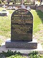
Local Aboriginal men like Yarri, Jacky Jacky, and Long Jimmy saved over 40 people. They used bark canoes to rescue people from the floodwaters.
After another high flood in 1853, the town was rebuilt. North Gundagai was moved to higher ground, away from the river. South Gundagai was also rebuilt on higher slopes. The town remembered the 150th anniversary of the flood in 2002.
In 1891, another flood left people stranded in trees. Edward True, who couldn't even swim, bravely saved several men. He was awarded for his courage.
Sadly, in recent years, the Gundagai wetlands have disappeared. These wetlands were home to many birds. They were lost mainly due to cattle walking on the land and water being diverted.
Other major floods also happened in 1974 and 2012.

Bushrangers in the Gundagai Area
From as early as 1838, bushrangers caused trouble in the Gundagai area. These were armed outlaws who robbed people.
In 1843, a gang of five bushrangers, including one called 'Blue Cap', robbed the Gundagai postmaster. Other bushrangers like Cushan and Jack-in-the-Boots were also active.
In 1864, Sergeant Parry was shot and killed by the bushranger John Gilbert. Gilbert was part of Ben Hall's gang. This happened during a mail coach robbery near Jugiong.
The North Gundagai Anglican cemetery has the graves of two policemen killed by bushrangers. Senior Constable Webb-Bowen was killed by Captain Moonlite in 1879. Trooper Edmund Parry, killed by Ben Hall's gang, is buried next to him. Captain Moonlite is also buried there. He had asked to be buried near his friends who died in the same shootout. His wish was granted in 1995.
Tent Cities and Early Camps
The old Gundagai Flour Mill was known as 'The Sundowners'. Many swaggies (travelers looking for work) camped there. 'Sam the Sundowner', a famous Australian swaggie, was known for rescuing people from rivers.
In 1901, a very large camp of unemployed men and their families was in South Gundagai. They were waiting for the railway line construction to start. There were also tent towns for railway workers near the station.
The Chinese camp was where the Bowls Club is today. There were also miner's camps at gold mining sites around Gundagai. Flower Hill, north of Gundagai, once had a large tent settlement, even bigger than the permanent town.
Riverboat Trade on the Murrumbidgee
Several riverboats were important for Gundagai. These included the 'Explorer', 'Gundagai', 'Albury', 'Nangus', and 'J.H.P.'.
In 1853, Captain Francis Cadell ran the first steamer on the Murray River. In 1856, he brought the 'Albury' and 'Gundagai' steamers from Scotland. They were put together at Goolwa and then launched.
The 'Albury' was the first steamer to visit Gundagai in 1858. It traveled up the Murrumbidgee River. The 'Explorer' steamer had surveyed the river in 1855 to see if it was good for boats.
The 'Nangus' steamer was built near Gundagai in 1865. It was used to transport goods between Gundagai and Hay. However, it sank near Wagga in 1867 after hitting something in the water.
The 'J.H.P.' steamer was launched in 1866. It sank multiple times before being taken apart in 1879.
Gundagai's Population and Environment
In 1911, Gundagai Shire had 1,921 people. The population stayed similar throughout the 20th century. In 2016, Gundagai had 1,925 residents. Most people (85.6%) were born in Australia and spoke only English at home.
| Historical population | ||
|---|---|---|
| Year | Pop. | ±% |
| 1921 | 1,150 | — |
| 1933 | — | |
| 1947 | — | |
| 1954 | 2,127 | — |
| 1961 | 2,167 | +1.9% |
| 1966 | 2,116 | −2.4% |
| 1971 | 2,078 | −1.8% |
| 1976 | 2,074 | −0.2% |
| 1981 | 2,308 | +11.3% |
| 1986 | 2,124 | −8.0% |
| 1991 | 2,069 | −2.6% |
| 1996 | 2,064 | −0.2% |
| 2001 | 1,989 | −3.6% |
| 2006 | 1,998 | +0.5% |
| 2011 | 1,926 | −3.6% |
| 2016 | 1,925 | −0.1% |
| 2021 | 1,970 | +2.3% |
| Source: Australian Bureau of Statistics data. | ||
Gundagai's Geography and Climate
Gundagai is an inland town located about 250 meters (820 feet) above sea level. Most of the area is part of the Riverina agricultural region.
North Gundagai is built on ancient rock formations. These rocks show links to the supercontinent Gondwana from millions of years ago.
The land has been mostly cleared for farming. Over 80% of the area is used for growing crops and raising animals. Less than 1% is kept for nature conservation.
Gundagai Shire is mostly rural. Most of its people live in the town of Gundagai. There are also four small villages: Coolac, Tumblong, Muttama, and Nangus.
Gundagai has a warm temperate climate. It has hot summers and mild winters.
| Climate data for Gundagai | |||||||||||||
|---|---|---|---|---|---|---|---|---|---|---|---|---|---|
| Month | Jan | Feb | Mar | Apr | May | Jun | Jul | Aug | Sep | Oct | Nov | Dec | Year |
| Record high °C (°F) | 43.7 (110.7) |
44.0 (111.2) |
39.4 (102.9) |
33.9 (93.0) |
26.5 (79.7) |
21.9 (71.4) |
20.2 (68.4) |
25.9 (78.6) |
28.6 (83.5) |
36.0 (96.8) |
41.6 (106.9) |
42.6 (108.7) |
44.0 (111.2) |
| Mean daily maximum °C (°F) | 32.5 (90.5) |
31.2 (88.2) |
28.1 (82.6) |
22.9 (73.2) |
17.9 (64.2) |
13.9 (57.0) |
12.8 (55.0) |
14.9 (58.8) |
18.3 (64.9) |
22.0 (71.6) |
26.3 (79.3) |
29.6 (85.3) |
22.5 (72.5) |
| Mean daily minimum °C (°F) | 16.7 (62.1) |
16.8 (62.2) |
13.2 (55.8) |
8.6 (47.5) |
5.3 (41.5) |
3.5 (38.3) |
2.5 (36.5) |
3.1 (37.6) |
5.5 (41.9) |
8.0 (46.4) |
12.0 (53.6) |
13.8 (56.8) |
9.1 (48.4) |
| Record low °C (°F) | 5.9 (42.6) |
6.3 (43.3) |
4.5 (40.1) |
−0.8 (30.6) |
−3.1 (26.4) |
−4.6 (23.7) |
−5.5 (22.1) |
−4.8 (23.4) |
−2.0 (28.4) |
−1.6 (29.1) |
1.7 (35.1) |
5.1 (41.2) |
−5.5 (22.1) |
| Average precipitation mm (inches) | 39.0 (1.54) |
51.8 (2.04) |
41.4 (1.63) |
32.4 (1.28) |
37.1 (1.46) |
65.4 (2.57) |
64.2 (2.53) |
58.8 (2.31) |
64.2 (2.53) |
59.0 (2.32) |
66.4 (2.61) |
56.4 (2.22) |
636.2 (25.05) |
| Average precipitation days | 5.7 | 5.5 | 5.4 | 5.4 | 7.1 | 11.7 | 13.4 | 11.8 | 10.9 | 9.6 | 8.3 | 7.1 | 101.9 |
Gundagai's Economy and Industries
Gundagai's economy relies on tourism, farming, and some industries. Visitors come to see its history and famous bridges.
Farming is very important, with sheep and cattle raised here. Farmers also grow wheat, lucerne, and maize.
Local industries include the Gundagai Meat Processors Plant, which is the largest employer. D J Lynch Engineering also makes steel parts for big projects.
Gold Mining in Gundagai
Gold was first found near Gundagai in 1842. A gold rush started in 1858 after more gold was discovered. Mining continued until 1875, and then another gold rush happened in 1894.
Some famous mines were the Robinson and Rice's Mine and the Prince of Wales Mine. Herbert Hoover, who later became a US President, worked as a mining engineer at the Prince of Wales Mine around 1900.
Nangus Island, in the Murrumbidgee River, was also an early goldfield.
Other Mining Activities
Asbestos was first mined for money in Australia at Gundagai. Other minerals like chromite, talc, magnesite, copper, and slate were also mined in the area.
Famous Places in Gundagai
Gundagai Bakery
The Gundagai Bakery is the oldest bakery in Australia. It first opened its doors in 1864.
Rusconi's Marble Masterpiece
Frank Rusconi, a local stone carver, created an amazing miniature Italian palace. He made it from 20,948 pieces of marble from New South Wales. The palace is 1.2 meters (about 4 feet) tall and took 28 years to finish, starting in 1910. You can see it at the Gundagai tourist office.
Rusconi also sculpted the base for the famous Dog on the Tuckerbox monument. He made the model of the dog, which was then cast in metal.
Niagara Café
The Niagara Café opened in 1938. It was a popular stop on the Hume Highway. The cafe proudly displays items used by former Prime Minister, John Curtin, during his visit in 1942. It was the oldest Greek-run cafe in Australia. After closing in 2019, it was restored and reopened in 2022.
Heritage Listed Sites
Many places in Gundagai are listed as important heritage sites. This means they are protected because of their historical value.
- Gundagai Rail Bridge over Murrumbidgee River
- Gundagai railway station
- Gundagai Courthouse
- Gundagai District Hospital
- Murrumbidgee River Underbridge, Gundagai
- Gundagai Rail Bridge Approaches
- Old Gundagai Town Site
- Prince Alfred Bridge

River Crossings and Bridges
Gundagai is located at a natural crossing point of the Murrumbidgee River. Travelers used to cross the river here. This crossing eventually became part of the Great South Road.
The Great Southern Road was declared a main road in 1858. It connected Sydney to Albury. In 1928, it was named the Hume Highway. In 1977, the highway bypassed Gundagai with the opening of the Sheahan Bridge.
Old Fords and Bridges
There are several old river crossings, called fords, around Gundagai. These include fords across Jones Creek, Morleys Creek, and the Murrumbidgee River itself.
Some old bridges no longer exist. Learys Bridge and Rileys Bridge, which crossed Morleys Creek, were either burned down or washed away by floods.
Important Bridges


In 1867, the Prince Alfred Bridge was finished across the Murrumbidgee River. It was a wrought iron bridge, 314 meters (1,030 feet) long. It was the first iron truss bridge built in New South Wales.
Over time, parts of the bridge were replaced and lengthened. By 1896, it was 922 meters (3,025 feet) long. It was the longest bridge in New South Wales until the Sydney Harbour Bridge was completed in 1932. The Prince Alfred Bridge was used until 1977.
In 1903, a second bridge was built for the railway line. It was 819 meters (2,687 feet) long.
In 1977, the third bridge, the Sheahan Bridge, was opened. This modern concrete bridge is part of the Hume Highway bypass. It is 1,143 meters (3,750 feet) long, making it a very long bridge. It was named after Bill Sheahan, a local politician. In 2010, a second Sheahan Bridge was built next to it to carry southbound traffic.
Gundagai: An Australian Icon
Gundagai is often mentioned in Australian stories, songs, and poems. It has become a symbol of a typical Australian country town. The area also has many traditional stories from both Aboriginal people and early European settlers. It was an important meeting place for travelers, farmers, and workers.

Gundagai is mentioned in many famous works. These include poems like "'Ode to the Dead of Gundagai" and "Nine Miles From Gundagai." There are also popular songs like "Where the Dog Sits on the Tuckerbox (Five Miles from Gundagai)" and "Along The Road To Gundagai."
Famous Australian writers like Banjo Paterson and Henry Lawson have also written about Gundagai. Miles Franklin's "Brent of Bin Bin" books are set in the area and describe the 1852 flood.
Culture and Events in Gundagai
Sports in Gundagai
.jpg)
The most popular sport in Gundagai is rugby league. The Gundagai Tigers team plays in the Group 9 Rugby League competition. Their games at Anzac Park Oval often attract thousands of fans.
Cultural Events and Festivals
The Snake Gully Cup festival happens every November. It includes a two-day horse racing event, which is one of the biggest in southern New South Wales. The idea for the Snake Gully Cup started in the 1970s. It became a major event in 1992. The second day of the festival is called 'Hair of the Dog' and is more for families.
The Turning Wave Festival, which celebrated Irish and Celtic culture, used to be held in Gundagai. It moved to Yass in 2012.
Council Changes
In 2016, the Gundagai and Cootamundra councils were combined to form the Cootamundra–Gundagai Regional Council. Many people in Gundagai were against this change. Signs protesting the merger were displayed for several years. In August 2022, plans began to separate the councils again. This is expected to be completed in 2024.
Images for kids
-
Memorial to Yarri in the Gundagai cemetery

