Hager Mountain facts for kids
Quick facts for kids Hager Mountain |
|
|---|---|

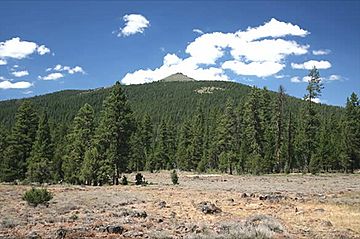
Base-to-summit view of Hager Mountain
|
|
| Highest point | |
| Elevation | 7,189 ft (2,191 m) NAVD 88 |
| Prominence | 1,455 ft (443 m) |
| Geography | |
| Location | Lake County, Oregon, U.S. |
| Topo map | USGS Hager Mountain |
| Geology | |
| Age of rock | Over 5 million years |
| Mountain type | Silicic lava dome |
| Climbing | |
| Easiest route | Steep road (for government lookout use only) |
| Normal route | Hike |
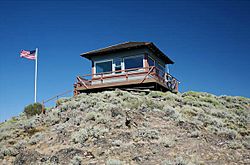
Hager Mountain is a cool volcanic peak located in Oregon, USA. It sits in the northwest part of the Basin and Range Province. You can find this mountain south of a small town called Silver Lake. It's also part of the Fremont–Winema National Forest. At the very top, there's a special fire lookout station. Forest Service workers use it during summer and fall to spot wildfires. Many hiking trails lead up to this lookout.
Contents
Discover Hager Mountain's Landscape
Hager Mountain is on the edge of Oregon's high desert. It's in Lake County, about 10 miles (16 km) south of Silver Lake. The mountain's highest point is 7,189 feet (2,191 meters) above sea level. It stands out quite a bit from the land around it, rising 1,455 feet (443 meters).
Hager Mountain is a huge lava dome. It was formed about 5.9 million years ago from volcanic eruptions. The main rock here is called Hayes Butte Basalt. This rock came from lava flows that erupted from a crack in the earth. The lava flowed down the mountain's sides and spread across the plains below. These lava flows happened during a time called the Pliocene epoch.
Over time, the Hayes Butte Basalt rock breaks down into thin, rocky soil. Today, Hager Mountain's soil is a mix of fine dirt, gravel, and bigger rock pieces. You can find rocks like basalt, andesite, pumice, and obsidian on the surface.
Plants and Animals of Hager Mountain
Hager Mountain is located east of the Cascade Range. To the west, you'll find thick ponderosa and lodgepole pine forests. These forests reach up to the timberline on the Cascade peaks, about 50 miles (80 km) away. The areas north and east of the mountain are much drier, like a typical high desert.
The lower and middle parts of Hager Mountain are covered in pine trees. Underneath these trees, you'll see low sagebrush and other shrubs like curl-leaf mountain mahogany and antelope bitterbrush. Smaller plants include Indian paintbrush, yellow balsamroots, and common yarrow. Different types of grasses also grow here, such as Idaho fescue. A few western juniper trees grow on the lower northeast slopes.
Hager Mountain is home to many different animals. Large mammals include black-tailed deer, elk, coyotes, black bear, bobcats, and cougars. Smaller animals you might see are American badgers, porcupines, striped skunks, and different kinds of jackrabbits and squirrels.
Many birds live around Hager Mountain too. You might spot mountain chickadees, Lazuli buntings, green-tailed towhees, and white-crowned sparrows. There are also several types of woodpeckers, like the black-backed woodpecker. Bigger birds like barn owls, great horned owls, red-tailed hawks, and golden eagles fly over the area.
The Story of Hager Mountain
The Klamath people, who lived in this part of Oregon, called the mountain Chock-chock-lisk-se. This name means "bald faced rock." Some old maps even called it Bald Mountain. Later, early settlers named it Hagerhorst Mountain after a rancher who lived nearby. Over time, the name became shorter, and now we call it Hager Mountain.
The United States Forest Service built a fire lookout on Hager Mountain. They started using it full-time in 1915 to watch for fires. The first lookout building was replaced with a new one in 1954. The current lookout is a 14-foot (4.3 m) by 14-foot (4.3 m) cabin. It has big glass windows on all sides, giving the forest guard a 360-degree view. The Forest Service uses the lookout from June to October each year. There's a dirt road to the top, but only the lookout staff can use it. It's not open to the public.
Fun Things to Do at Hager Mountain
In the summer, there are lots of fun activities around Hager Mountain. You can go hiking, horseback riding, mountain biking, bird watching, and wildlife viewing. It's also a great place for camping and photography. When winter comes, cross-country skiing and snowshoeing become popular. The weather can change quickly, especially in winter. So, it's always a good idea to check the weather forecast before you go.
There are three main trails for day-hikes to the top of Hager Mountain. The easiest trail is a 2-mile (3.2 km) roundtrip. It starts from a road gate on the west side of the mountain. This trail climbs about 785 feet (239 m) and is usually open from June to mid-November.
A slightly harder trail is 3.3 miles (5.3 km) one way. Its starting point is on the northwest side, near Forest Road 012. This trail climbs 1,710 feet (521 m). The longest trail is an 8-mile (12.9 km) roundtrip hike. It begins near milepost 9 on Forest Road 28, on the east side. This trail has an elevation gain of 1,990 feet (607 m). The two longer trails meet up and then connect to the Fremont National Recreation Trail.
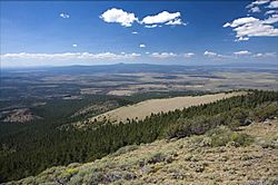
From the lookout station at the top, you get amazing views. You can see the Cascade peaks to the west and the high-desert country to the north and east. On a clear day, you might even see Mount Hood to the north and Mount Shasta to the south!
A Forest Service guard lives at the Hager Mountain lookout during the summer fire season. But visitors are still welcome to visit the lookout during this time. After fire season, from November to May, you can even rent the lookout! It has a wood stove for heat, a propane stove for cooking, and a propane refrigerator. There's a bed and three sleeping cots. Outside, you'll find a picnic table and an outhouse. Just remember, there's no drinking water available at the site.
More to Explore
 | Kyle Baker |
 | Joseph Yoakum |
 | Laura Wheeler Waring |
 | Henry Ossawa Tanner |


