Hardy County, West Virginia facts for kids
Quick facts for kids
Hardy County
|
||
|---|---|---|

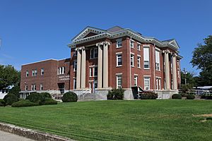
Hardy County Courthouse
|
||
|
||

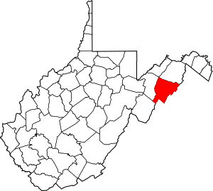
Location within the U.S. state of West Virginia
|
||
 West Virginia's location within the U.S. |
||
| Country | ||
| State | ||
| Founded | October 17, 1786 | |
| Named for | Samuel Hardy | |
| Seat | Moorefield | |
| Largest town | Moorefield | |
| Area | ||
| • Total | 584 sq mi (1,510 km2) | |
| • Land | 582 sq mi (1,510 km2) | |
| • Water | 2.2 sq mi (6 km2) 0.4%% | |
| Population
(2020)
|
||
| • Total | 14,299 | |
| • Estimate
(2021)
|
14,160 |
|
| • Density | 24.485/sq mi (9.454/km2) | |
| Time zone | UTC−5 (Eastern) | |
| • Summer (DST) | UTC−4 (EDT) | |
| Congressional district | 2nd | |
Hardy County is a special area, like a district, in the state of West Virginia. In 2020, about 14,299 people lived there. The main town, or "county seat," is Moorefield. Hardy County was formed in 1786 from a larger area called Hampshire County. It was named after Samuel Hardy, an important person from Virginia.
Contents
History of Hardy County
The first European known to visit this area was John Van Meter in 1725. The first lasting European settlements started in the 1730s.
Hardy County was officially created in 1786. It was part of Virginia back then. In 1863, it became one of the first 50 counties in the new state of West Virginia.
At that time, the new state divided its counties into smaller areas called "civil townships." This was meant to help local governments. But it was hard to do in a rural state like West Virginia. So, in 1872, these townships became "magisterial districts." Hardy County was split into three districts: Capon, Lost River, and Moorefield. Later, two more districts were added: South Fork in 1873 and Old Fields in the 1980s.
Hardy County has a rich history for African Americans. Many free African Americans lived there before the Civil War. This history is shared in a TV series called African American Lives by Henry Louis Gates.
Geography and Nature
Hardy County covers a total area of about 584 square miles. Most of this (582 square miles) is land. Only a small part (2.2 square miles) is water.
The South Branch Potomac River flows through the county. It has a beautiful valley around it. This wide valley, often called "the Valley," has very fertile land. This makes it great for farming. Farming and raising animals have always been the main jobs here. People grow corn, wheat, apples, peaches, and melons. They also raise cattle and chickens. Many families also have their own small gardens.
High mountains with rough land and thick forests are on both sides of the Valley. There's lots of wildlife in the area. Hunting has always been a popular activity and a way to get food.
The South Branch River is clear and wide. In many places, it's quite deep. It waters the Valley and is full of fish. The river also creates many pretty scenes. Sometimes, the calm river overflows its banks. It can then flood the rich lands around it.
The Trough: A Unique River Path
The river has a very interesting feature. Thousands of years ago, the river didn't cut across the mountains. Instead, it flowed through them from one end to the other. This special path is now a narrow, deep gap. It's about 7 miles long and is called "The Trough". Today, this gorge is hundreds of feet deep. The South Branch River flows in a narrow channel at the bottom. The rock walls on either side are almost straight up and down.
Moorefield: The County Seat
In the middle of the South Branch Valley is Moorefield. It's surrounded by high mountains. Moorefield is the county seat of Hardy County. It sits where the South Fork South Branch Potomac River joins the South Branch Potomac. In 1860, Moorefield was a quiet farming center. About 1,500 people lived in the area then. At that time, there were no bridges in Moorefield. People had to cross the South Branch River by walking through it or using a busy ferry boat. The main towns that connected with Moorefield were Petersburg, Romney, and New Creek (now Keyser).
Major Roads in Hardy County
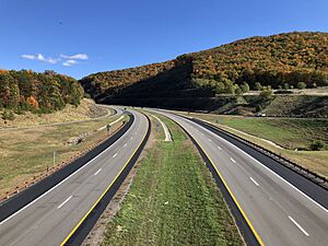
 U.S. Highway 48
 U.S. Highway 220
 West Virginia Route 28
 West Virginia Route 29
 West Virginia Route 55
 West Virginia Route 59
 West Virginia Route 259
Neighboring Counties
- Hampshire County (north)
- Frederick County, Virginia (east)
- Shenandoah County, Virginia (southeast)
- Rockingham County, Virginia (south)
- Pendleton County (southwest)
- Grant County (west)
Protected Natural Areas
- George Washington National Forest (part of it)
- United States National Radio Quiet Zone (part of it)
People and Population
| Historical population | |||
|---|---|---|---|
| Census | Pop. | %± | |
| 1790 | 7,336 | — | |
| 1800 | 6,627 | −9.7% | |
| 1810 | 5,525 | −16.6% | |
| 1820 | 5,700 | 3.2% | |
| 1830 | 6,798 | 19.3% | |
| 1840 | 7,622 | 12.1% | |
| 1850 | 9,543 | 25.2% | |
| 1860 | 9,864 | 3.4% | |
| 1870 | 5,518 | −44.1% | |
| 1880 | 6,794 | 23.1% | |
| 1890 | 7,567 | 11.4% | |
| 1900 | 8,449 | 11.7% | |
| 1910 | 9,163 | 8.5% | |
| 1920 | 9,601 | 4.8% | |
| 1930 | 9,816 | 2.2% | |
| 1940 | 10,813 | 10.2% | |
| 1950 | 10,032 | −7.2% | |
| 1960 | 9,308 | −7.2% | |
| 1970 | 8,855 | −4.9% | |
| 1980 | 10,030 | 13.3% | |
| 1990 | 10,977 | 9.4% | |
| 2000 | 12,669 | 15.4% | |
| 2010 | 14,025 | 10.7% | |
| 2020 | 14,299 | 2.0% | |
| 2021 (est.) | 14,160 | 1.0% | |
| U.S. Decennial Census 1790–1960 1900–1990 1990–2000 2010–2020 |
|||
Hardy County in 2010
In 2010, there were 14,025 people living in Hardy County. They lived in 5,818 homes, with 3,900 of those being families. The population density was about 24 people per square mile.
Most people (93.8%) were white. About 2.5% were Black or African American. About 1.0% were Asian, and 0.2% were American Indian. About 1.5% were from other races, and 1.0% were from two or more races. People of Hispanic or Latino background made up 3.4% of the population.
Many people had German (42.7%), English (13.2%), American (11.0%), or Irish (9.9%) family backgrounds.
About 29% of homes had children under 18 living there. About 52% were married couples. The average age of people in the county was 42.8 years old.
Towns and Communities
Main Towns
- Moorefield (This is the county seat, the main town)
- Wardensville
Magisterial Districts
- Capon
- Lost River
- Moorefield
- Old Fields
- South Fork
Smaller Communities
See also
 In Spanish: Condado de Hardy para niños


