Hobart coastal defences facts for kids
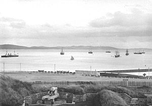
The Hobart coastal defences were a group of old forts and gun batteries built to protect the city of Hobart, Tasmania. These forts were created by the British in the 1800s. Some even had secret tunnels connecting them!
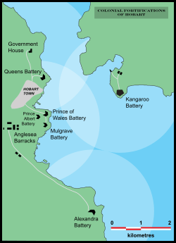
Back then, Hobart was a very important port for ships from all over the world. It was a major trading hub for the British Empire. Because of this, it was super important to keep the city safe from enemy warships. From 1804 to 1942, 12 different defence spots were built around Hobart.
Before Australia became one country (called Federation), Tasmania was a British colony. Britain was often at war with countries like France and Russia. In 1788, the British had already started a colony in Sydney. But they thought Tasmania would be a good second colony. It was an island, which made it perfect for a penal colony (a place to send prisoners). It also had lots of timber, which the Royal Navy needed for ships.
In 1803, Britain decided to colonise Tasmania. They wanted to set up a permanent settlement there, mainly to stop the French from doing it first. Britain and France had been fighting for years in the French Revolutionary Wars and would soon fight again in the Napoleonic Wars.
The first British settlement in Tasmania started on September 8, 1803, at Risdon Cove on the eastern side of the Derwent River. But in 1804, Lieutenant-Governor David Collins moved the settlement to Sullivans Cove on the western side.
Just days after moving, Collins knew the new colony needed protection. He worried the French might send warships up the river. So, a simple dirt fort, called a redoubt, was dug on a high spot near what is now Franklin Square. Two ship cannons were placed inside. For the next seven years, this muddy fort was Hobart Town's only defence.
In 1811, Governor Lachlan Macquarie visited Hobart Town. He was worried about how bad the defences were. He planned new streets and buildings, and he ordered the building of Anglesea Barracks. This barracks opened in 1814 and is still used today, making it Australia's oldest continuously used barracks. Macquarie also suggested building stronger forts. Following his advice, a new area of 8 acres (32,000 m2) was chosen at Battery Point. This is where the first of many new forts would be built.
Contents
Mulgrave Battery: Hobart's First Fort
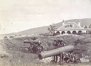
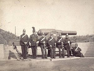
By 1818, a new fort was finished at Battery Point. It was named Mulgrave Battery after Henry Phipps, 1st Earl of Mulgrave. This fort had six guns that poked out through dirt openings called embrasures. At first, these were ship guns. But in 1824, they were replaced with bigger 32-pounder guns.
Once it was built, Mulgrave Battery got a lot of complaints from the soldiers who worked there. They said it wasn't good enough. One person even called it "a poor pitiful mud fort." Engineers reported that the gun carriages (the stands for the guns) were dangerous. So, new timber was sent in 1829 to make them safer. But by 1831, only one gun had been fixed. In the same year, the fort's underground passages were improved with large timber sections.
As the colony grew, more British soldiers were sent to Hobart Town. In 1835, Captain Roger Kelsall of the Royal Engineers arrived. He looked at the forts and said the colony was almost completely unprotected. He came up with a big plan to protect the whole inner harbour of the Derwent River. He wanted a network of strong batteries at Macquarie Point, Battery Point, and Bellerive Bluff. His idea was for the forts to have overlapping firing areas. This would stop enemy ships from entering or attacking the town.
This plan was huge for such a small colony, which had about 20,000 people in the 1830s. It was also very expensive. But work began in 1840, using convict labour (prisoners doing forced work). Mulgrave Battery was made bigger and stronger. A new fort was also started in 1840, a bit further up the hill behind Mulgrave Battery. In 1829, a semaphore station (for sending signals) was built above Mulgrave Battery. This allowed communication with ships and even with Port Arthur prison.
The modern suburb of Battery Point gets its name from the Mulgrave Battery. The original guardhouse, built in 1818, is the oldest building in Battery Point. It is also one of the oldest buildings still standing in Tasmania.
Prince of Wales and Albert Batteries: New Defences
The new fort, called the "Prince of Wales Battery," was finished in 1842. That year, ten new 8-inch (200 mm) muzzle-loading cannons were put in place. These guns greatly increased the colony's firepower. But even with its strong guns, the fort's location and firing angles weren't very good. The powder magazine (where gunpowder was stored) was set up in 1845.
The Mulgrave and Prince of Wales batteries were south of Sullivan's Cove, and the Queen's Battery was to the north. This setup continued until the Crimean War started with the Russian Empire. People worried that Russian warships might attack or even invade Hobart Town. So, they decided to review Hobart's defences. A group found that more strengthening was needed. Because of the problems with the Prince of Wales Battery, a third fort, the Albert Battery, was built even further up the hill behind it. It was named after Prince Albert, Queen Victoria's husband.
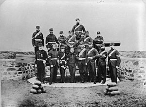
By 1855, Tasmania was given self-government by the British. The British government started to push Tasmania to take more responsibility for its own defence. As a result, the Tasmanian government began to create volunteer local military groups. One group, the Hobart Town Artillery Company, was formed in 1859. They started taking over the Hobart forts from the Royal Artillery, who were slowly leaving. All British forces left Tasmania by 1870. Before this, in 1868, a Defence Proposals paper said that more forts were needed. It also suggested new forts further south on both sides of the river.
Ship weapons were getting better. This meant the existing forts, which could only fire about 1830 metres, were no longer effective. Enemy ships could sit outside the range of the defenders' guns and still bomb the town. This left the colony almost defenceless.
In January 1882, three Russian warships arrived. Even though Britain and Russia had fought in the Crimean War, these ships were on a friendly visit. But if they had been hostile, Hobart would have easily fallen. This visit caused a big debate about how weak the colony's defences were.
The visit also showed how old and broken down the existing forts were. Another review was done, and it was decided that the Mulgrave, Prince of Wales, and Albert Batteries were not good enough. By 1878, both were declared useless and were taken apart by 1881. In 1882, the land was given to the Hobart City Council to be used as a public park. Most of the stone was moved and used to build the Alexandra Battery further south.
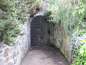
After the forts closed, the entrance to the old magazine became a popular place for children to play. At night, the underground rooms were often used by men to drink and play cards. The council closed and locked them permanently in 1934. Today, the park where these forts once stood is still a popular public park. It is called Princes Park, honouring the soldiers who served there. The iron gate to the underground magazine rooms can still be seen at the bottom of the park.
Queen's Battery: A Grand Vision
Major Roger Kelsall also suggested another fort on the north-eastern side of Hobart Town. This spot, almost exactly where the Hobart Cenotaph war memorial is now on Queens Domain, was chosen. Construction started in 1838, and the fort opened the same year as Queen's Battery, named after Queen Victoria. It was meant to be the grandest fort in Hobart, overlooking the entrance to Sullivans Cove. However, the full plans were never completed. The fort faced delays and money problems, and wasn't finished until 1864.
With British forces leaving in 1870, a major review of defences happened in 1868. It was decided that the current system couldn't handle new naval weapons. Two new forts would be built at One Tree Point and Bellerive Bluff. The Queen's Battery would be the top point of a triangle of forts covering the entrance to Sullivans Cove.
A handbook was created in 1868, suggesting that 226 men would need about 30 minutes to fire 365 rounds from the 20 guns available to stop an enemy ship. Despite this, Queen's Battery became an important defence. It stayed in use until the 1920s. When the site was dug up in 1992, a hot shot oven was found. This oven was used to heat cannonballs until they were red hot. These "hot shots" were meant to set wooden ships on fire. They were never actually fired in a real battle. The oven and digging areas were later filled in.
Alexandra Battery: New Strategy
After the Mulgrave, Prince of Wales, and Albert batteries were declared useless in 1878, the plans for new defences around Sullivans Cove were brought back. These plans were first made in 1868.
The idea was a triangle of forts: Queen's Battery at the top, and two new batteries. These were the Alexandra Battery, named after Princess Alexandra, and the Kangaroo Battery on the eastern shore. Construction on the new forts began in 1880. At the same time, a new permanent artillery unit, the Southern Tasmanian Volunteer Artillery, was formed. They had two 12-pound howitzers and two 32-pound guns.
When the Battery Point forts were taken apart, much of their stonework was moved to the Alexandra Battery. Today, the Alexandra Battery site is a public park with amazing views of the river. Much of the original fort can still be explored.
Kangaroo Battery: A Stronghold
The visit of Russian warships in 1873 and the closing of the Battery Point forts in 1878 sped up the building of the Alexandra and Kangaroo Batteries.
The Kangaroo Battery was designed in a pentagon shape to fit perfectly on the bluff (a steep cliff). The ditch, tunnels, and underground rooms had to be carved out of solid stone and covered with masonry (stone or brickwork). Many small openings and firing ports were built into the stone. These allowed rifle fire from every side of the fort. If enemy soldiers tried to attack on foot, special defence points called caponiers faced both land sides of the fort. This meant the only safe way to attack the fort was up the very steep cliffs of Kangaroo Bluff.
Access to the caponiers was through iron hatches that opened into deep passageways. These led to tunnels that connected to underground magazines (for gunpowder), stores, a lamp room, a well, and loading galleries. The loading galleries were clever. They allowed guns to be loaded from the front (muzzle-loaded) with shells that were dragged along a conveyor belt directly to the gun's muzzle when it was tilted down.
Building the Kangaroo Battery started in September 1880. Colonel Peter Scratchley, a Royal Engineer, was in charge of building defences for all the Australian colonies. Work was slow because of money problems and delays. But in May 1883, Patrick Cronly took over. Work was finished the next year when two huge 14-tonne (eight-inch, 203 mm) cannons arrived from England. The fort cost £8,150 (about A$16,300) at a time when workers earned about 4 shillings (50c) a day.
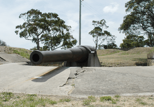
The guns fired shells weighing 81.7 kg. Thanks to their rifling (grooves inside the barrel), they were very accurate and had excellent range. In 1888, two smaller QF 6 pounder Nordenfelt guns were added. Their projectiles were only 2.7 kg, but they were also very accurate. The same year, a Nordenfelt machine gun was put at the fort's entrance gate.
The first shots were fired on February 12, 1885. Later that year, a dry mound and a deeper wet moat (a ditch filled with water) were added. Fences were built around the moat in November 1885 after a local boy fell in and drowned.
From 1887, both the Alexandra and Kangaroo Batteries were manned by soldiers from the Southern Tasmanian Volunteer Artillery and the Tasmanian Permanent Artillery. In 1901, Tasmania joined the new Federation of Australia. All the city's forts then became controlled by the Commonwealth government. Kangaroo Fort stayed in use until the 1920s, but it never fired a shot in anger (meaning it never fired at an enemy). In 1925, all the guns were buried because they were old and useless. In 1930, the Clarence City Council took over the site for a public park. In 1961, the site was acquired by the Scenery Preservation Board. In 1970, it became a historical site. The guns were dug up and put on display. Today, the site is managed by the Tasmanian National Parks and Wildlife Service and is a popular place for visitors.
Fort Direction and Pierson's Point: World War II Defences
When World War II started, the Department of Defence bought land near South Arm in September 1939. This land was close to the mouth of the Derwent River. At first, it was just a training ground. But as the war continued, the Commonwealth decided that Hobart's port needed protection. This was because Tasmania's zinc industry was very important for the war effort.
Major Mark Pritchard was the first commander of these new defences, which became known as Fort Direction. By the end of 1939, two fortified six-inch (152 mm) Mk VII gun emplacements were built. A small control building was also finished. Soon, there was also a flagpole and naval signals.
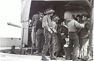
Throughout the war, a 24-hour watch was kept every day. At least 15 Royal Australian Navy personnel usually manned the site. A record of every ship entering the Derwent River between 1940 and 1945 was kept. From 1941 to 1944, both guns were used regularly for training. Although they never fired at enemy ships, the guns were fired in anger once. A cargo ship entering the Derwent River didn't follow instructions. So, one shell was fired accurately across its front, and the ship immediately stopped.
On the opposite western shore of the Derwent River, another gun placement was built with one four-inch (102 mm) gun. Several huts were built there to house soldiers. There was also a complex tunnel and command system. Local people remember barbed wire still around the site long after the war and when it was no longer used. Nearby Goat Bluff also had more tunnel systems.
The only enemy action to affect Hobart happened on August 1, 1942. A Japanese spy plane, launched from a submarine, flew from Great Oyster Bay south along Tasmania's east coast. Then it flew north along the Derwent River, looking at Hobart, before returning to its submarine. Both gun emplacements detected the plane, but it was too high to shoot at. No aircraft were available to stop it. After this event, two anti-aircraft guns were placed on nearby hills. But the Japanese never returned to Tasmania during the war.
Fort Nelson: A Modern View
Fort Nelson was an artillery battery built on top of Porter Hill around 1904. It had amazing views of the Derwent Estuary. Today, several modern houses have been built on top of the ruins of the fort's gun emplacements.
 | Sharif Bey |
 | Hale Woodruff |
 | Richmond Barthé |
 | Purvis Young |


