
Hockenheim facts for kids
Quick facts for kids
Hockenheim
|
||
|---|---|---|
|
Town
|
||

Town hall
|
||
|
||
| Country | Germany | |
| State | Baden-Württemberg | |
| Admin. region | Karlsruhe | |
| District | Rhein-Neckar-Kreis | |
| Municipal assoc. | Altlußheim | |
| Area | ||
| • Total | 13.45 sq mi (34.84 km2) | |
| Elevation | 335 ft (102 m) | |
| Population
(31 December 2010)
|
||
| • Total | 21,118 - Density /km2 (1,570 /sq mi) | |
| • Density | 1,570/sq mi (606/km2) | |
| Time zone | UTC+1 (CET) | |
| • Summer (DST) | UTC+2 (CEST) | |
| Area code(s) | 06205 | |
| Licence plate | HD | |

Hockenheim is a German town located in the northwest part of Baden-Württemberg. It is about 20 kilometers south of Mannheim. The town sits in the Upper Rhine valley. It is also on two special tourist routes. These are the Baden Asparagus Route ("Badische Spargelstraße") and the Bertha Benz Memorial Route. Hockenheim is most famous for its motor racing track, the Hockenheimring.
Hockenheim is one of the six biggest towns in the Rhein-Neckar-Kreis district. Since 1999, more than 20,000 people have lived there. In 2001, Hockenheim became a "regional central town" ("Große Kreisstadt").
Contents
Discovering Hockenheim's Location
Where Hockenheim is Situated
Hockenheim is found in the Upper Rhine valley. It is on an old trade route that once connected Frankfurt to Basel. The Kraichbach river flows through the town. It divides Hockenheim into an eastern and a western part.
Hockenheim covers an area of 34.84 square kilometers. About 28.2 percent of this land is used for buildings and roads. Around 47.5 percent is used for agriculture. About 2.3 percent of the area is made up of waterways. The remaining 21.1 percent is covered by forests.
The town has two main natural areas. The "Rheinaue" is to the west, and the "Niederterrasse" is to the east. The "Hockenheimer Rheinbogen" is a special area along the Rhine river. About 656 hectares of this area are protected for nature conservation.
How Hockenheim is Organized
The main part of the town is one big area. For statistical reasons, it is divided into five smaller districts.
Hockenheim's Past: A Journey Through Time
Early Settlements and Roman Times
In 1984, an old brick kiln was found in Hockenheim during an excavation. Inside the kiln were bricks with stamps from the Roman Empire. The Roman Legio XIV Gemina was near Mainz from 71 AD to 92 AD. These bricks show that people lived in the Hockenheim area a very long time ago.
Hockenheim was first mentioned in 769. It was called "Ochinheim" in a document from the Lorsch Codex. This was a list of early monastery gifts. The name "Hockenheim" was first used in official papers in 1238. During the Middle Ages, Hockenheim was owned by different local rulers.

Challenges and Growth in Later Centuries
In the 17th century, French troops badly damaged Hockenheim twice. This happened in 1644 during the Thirty Years' War. It happened again in 1674 during the Franco-Dutch War. Tobacco was brought to the area by the French. Around this time, farmers started growing tobacco instead of hops.
In 1803, Hockenheim became part of Baden. The tobacco crop grew very well. Hockenheim was given town rights on July 22, 1895.
At the start of the 20th century, growing asparagus became very popular. It replaced most of the remaining hops farms. On May 29, 1932, the famous Hockenheimring opened with a motorcycle race. In January 1973, Hockenheim became part of the new Rhein-Neckar-Kreis district.
How Hockenheim is Governed
The town is led by the Lord Mayor ("Oberbürgermeister"). The people living in Hockenheim elect the Lord Mayor every 8 years. Dieter Gummer from the SPD has been the Lord Mayor since 2004. The local council of Hockenheim has 22 members. The Lord Mayor leads the council meetings.
In 1975, the Hockenheim government made an agreement. They formed a municipal association ("Verwaltungsgemeinschaft") with nearby villages. These villages are Altlußheim, Neulußheim, and Reilingen.
Hockenheim's Official Symbol: The Coat of Arms
The coat of arms of Hockenheim was adopted in 1609. It shows two silver hooks crossed diagonally on a sign. Below them is a golden lion with a crown. The lion is the symbol of the Electorate of the Palatinate. Hockenheim used to be part of this area. The hooks likely come from the town's name. The look of these symbols has changed a few times. But their current design has been official since 1895.
Sports in Hockenheim

The Hockenheimring is a famous motor racing track. It was built in 1932. It is one of the two home tracks for the Formula One German Grand Prix. The other track is the Nürburgring. The Hockenheimring has hosted this exciting F1 event more than 30 times since 1970.
Interesting Places to Visit in Hockenheim

A museum about growing tobacco was started in 1984. It was the first of its kind in Baden-Württemberg. The motorsport museum opened near the Hockenheimring in 1986. It has over 200 old motorcycles and engines. The "Gartenschaupark" was created in 1991 for a State Horticultural Show. It is Hockenheim's largest park, covering 16 hectares.
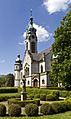
The town's water tower was built in 1910. It is in the Art Nouveau style. This tower is a famous landmark of the town. Other old buildings include the Protestant town church. This church was built in 1906 in a Neo-baroque style by architect Hermann Behaghel. The Catholic church was built in 1910. It is also in the Art Nouveau style and has a tall tower. The old Catholic church from 1817 is now a community center. It has a late Gothic choir tower.
Hockenheim's Global Connections
Hockenheim has special partnerships with other towns around the world. These are called "twin towns."
 Commercy, France, since 1970.
 Hohenstein-Ernstthal, Saxony, Germany, since 1990. This town was in former East Germany before Germany reunited.
 Mooresville, North Carolina, United States, since 2002.
Other website
Images for kids
-
The Protestant town church

See also
 In Spanish: Hockenheim para niños
