Homestead, Florida facts for kids
Quick facts for kids
Homestead, Florida
|
|||
|---|---|---|---|
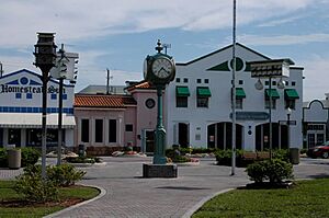
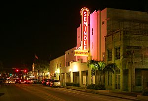
Homestead Historic Downtown District
|
|||
|
|||
| Motto(s):
"Gateway to Everglades & Biscayne National Parks" & "Discover the Opportunities"
|
|||
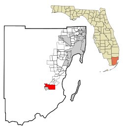
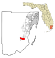
Location in Miami-Dade County and the U.S. state of Florida
|
|||
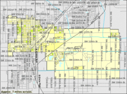
U.S. Census Bureau map showing city limits
|
|||
| Country | |||
| State | |||
| County | |||
| Incorporated | February 8, 1913 | ||
| Government | |||
| • Type | Council-Manager | ||
| Area | |||
| • Total | 15.58 sq mi (40.36 km2) | ||
| • Land | 15.08 sq mi (39.07 km2) | ||
| • Water | 0.50 sq mi (1.29 km2) 0.63% | ||
| Elevation | 3 ft (1 m) | ||
| Population
(2020)
|
|||
| • Total | 80,737 | ||
| • Density | 5,352.49/sq mi (2,066.63/km2) | ||
| Time zone | UTC−5 (Eastern (EST)) | ||
| • Summer (DST) | UTC−4 (EDT) | ||
| ZIP Codes |
33030–33035, 33039, 33090, 33092
|
||
| Area code(s) | 305, 786, 645 | ||
| FIPS code | 12-32275 | ||
| GNIS feature ID | 0284214 | ||
| Website | www.homesteadfl.gov | ||
Homestead is a city in Miami-Dade County, Florida. It is located in the U.S. state of Florida. The city sits between two amazing national parks: Biscayne National Park to the east and Everglades National Park to the west.
Homestead is mainly a suburb of Miami and a big area for farming. It is a major city in the Miami metropolitan area of South Florida. This larger area had about 6 million people in 2015. Homestead is about 26 miles (42 km) southwest of Miami and 25 miles (40 km) northwest of Key Largo. In 2020, the city's population was 80,737 people.
The city of Homestead is at the southern end of the Homestead Extension of Florida's Turnpike. This road connects with U.S. 1 here. Homestead is right next to Florida City. Together, they form the larger Homestead–Florida City area. Some nearby communities include Redland, Leisure City, Naranja, and Princeton.
Contents
History of Homestead
Homestead has a rich history, starting with the railway and how it got its unique name.
How Homestead Got Its Name
In 1898, the Florida East Coast Railway (FEC) planned to extend its train line from Miami to Key West. They wanted a new train station about 30 miles (48 km) south of Miami. Henry Flagler, who started the FEC, agreed. He suggested naming the station "Ingraham" after James E. Ingraham, who worked for the FEC.
However, Mr. Ingraham said no. He suggested the name "Homestead" instead. This was even though no one had officially "homesteaded" (claimed land for farming) in that exact spot yet. At that time, people were homesteading in the area now known as Redland, which is north and northwest of where the station was planned.
Early Development and First Settlers
Before the Homestead station was built, a railway surveyor named John S. Fredricks designed a town around the planned station. This land was owned by the FEC. It was common back then to plan towns around new train stations in undeveloped areas.
In July 1904, the Florida East Coast Railway opened its first station in what would become Homestead. In October 1904, William D. Horne arrived. He was a settler and businessman who bought the first lot in the new town. Soon after, Mr. Horne built the first private building in Homestead. It served as a store, a place for people to stay, and a post office. Today, this building is known as the historic Redland Hotel.
Becoming an Official City
Homestead officially became a city in 1913. It is the second oldest city in Miami-Dade County, after Miami itself. The name "Homestead" came about because the railway line to Key West was being built through an area where people were claiming land under the Homestead Act. The construction camp at the end of the line didn't have a name. So, materials for the workers were sent to "Homestead Country." The engineers who mapped the area shortened this to "Homestead."
Major Events in Homestead's History
The 1926 hurricane and a drop in real estate prices caused many small businesses and banks in Florida to close. Many people left Homestead because their homes were destroyed or flooded. Most did not have insurance and faced big mortgage payments.
On August 24, 1992, Hurricane Andrew hit Homestead and nearby South Miami-Dade County very hard. It was a powerful Category 5 hurricane.
Geography of Homestead
Homestead is a city with a total area of about 14.4 square miles (37.3 square kilometers). Most of this area, about 14.3 square miles (37.0 square kilometers), is land. Only a small part, about 0.1 square miles (0.3 square kilometers), is water.
City Size and Key Roads
Homestead is a small-sized city. From north to south, its city limits stretch about 4 miles (6 km). From east to west, they extend about 6 miles (10 km).
U.S. 1, also called Homestead Boulevard, runs through the middle of the city. It is the only way to continue south to the Florida Keys. At its southern end, Homestead and Florida City share a border.
Some important east-west streets in Homestead include Kings Highway, Campbell Drive, Mowry Drive, North Canal Drive/Lucy Street, and Palm Drive.
Homestead Air Reserve Base
The original Homestead Air Force Base was once a few miles northeast of Homestead. However, in the late 1990s, the city grew and took over some nearby land. Now, the city and the southwestern edge of the Homestead Air Reserve Base share a small border.
Local Attractions and Parks
A popular tourist spot near Homestead in Leisure City is Coral Castle. This unique structure was built by Edward Leedskalnin over 28 years, from 1923 to 1951. The Fruit and Spice Park is also a fun place to visit.
Climate in Homestead
Homestead has a tropical monsoon climate. This means it has hot and humid summers. High temperatures usually range from 90° to 92°F (32° to 33°C). Winters are warm and dry. The hottest temperature ever recorded was 100°F (38°C) in July and August 2023.
In summer, low temperatures are usually between 70° and 75°F (21° to 24°C). These lows are about 5 degrees cooler than coastal Miami because Homestead is more inland and rural. In winter, cold fronts bring cooler weather for short times from November to March. The lowest temperature ever recorded was 26°F (–3°C) in December 1934.
Winter high temperatures are usually between 68° and 80°F (18° to 26°C). Lows are between 57° and 64°F (8° to 14°C). Most of the rain happens in the summer. Homestead has a wet season from mid-May to early October. The dry season has some rain, mostly from cold fronts.
Snow flurries were even reported in the air at Homestead Air Force Base on January 20, 1977. This was the farthest south that snow flurries have ever been seen in the lower 48 United States.
| Climate data for Homestead, Florida (Miami Homestead General Aviation Airport), 1991–2020 normals, extremes 1910–present | |||||||||||||
|---|---|---|---|---|---|---|---|---|---|---|---|---|---|
| Month | Jan | Feb | Mar | Apr | May | Jun | Jul | Aug | Sep | Oct | Nov | Dec | Year |
| Record high °F (°C) | 89 (32) |
92 (33) |
93 (34) |
97 (36) |
100 (38) |
100 (38) |
100 (38) |
100 (38) |
98 (37) |
99 (37) |
92 (33) |
90 (32) |
100 (38) |
| Mean maximum °F (°C) | 85.0 (29.4) |
86.7 (30.4) |
89.0 (31.7) |
91.4 (33.0) |
93.4 (34.1) |
94.7 (34.8) |
95.5 (35.3) |
95.7 (35.4) |
94.0 (34.4) |
92.3 (33.5) |
87.5 (30.8) |
85.3 (29.6) |
96.5 (35.8) |
| Mean daily maximum °F (°C) | 77.5 (25.3) |
79.5 (26.4) |
81.8 (27.7) |
85.5 (29.7) |
88.4 (31.3) |
90.8 (32.7) |
92.0 (33.3) |
92.1 (33.4) |
91.0 (32.8) |
87.5 (30.8) |
82.5 (28.1) |
79.2 (26.2) |
85.6 (29.8) |
| Daily mean °F (°C) | 66.4 (19.1) |
68.0 (20.0) |
70.4 (21.3) |
74.3 (23.5) |
78.2 (25.7) |
81.7 (27.6) |
82.9 (28.3) |
83.2 (28.4) |
82.4 (28.0) |
78.9 (26.1) |
73.0 (22.8) |
69.0 (20.6) |
75.7 (24.3) |
| Mean daily minimum °F (°C) | 55.3 (12.9) |
56.6 (13.7) |
59.0 (15.0) |
63.2 (17.3) |
68.1 (20.1) |
72.7 (22.6) |
73.8 (23.2) |
74.3 (23.5) |
73.9 (23.3) |
70.4 (21.3) |
63.4 (17.4) |
58.7 (14.8) |
65.8 (18.8) |
| Mean minimum °F (°C) | 39.6 (4.2) |
42.7 (5.9) |
46.5 (8.1) |
52.1 (11.2) |
60.9 (16.1) |
69.0 (20.6) |
70.7 (21.5) |
71.3 (21.8) |
70.5 (21.4) |
60.5 (15.8) |
51.4 (10.8) |
45.0 (7.2) |
37.4 (3.0) |
| Record low °F (°C) | 27 (−3) |
26 (−3) |
26 (−3) |
39 (4) |
47 (8) |
56 (13) |
63 (17) |
64 (18) |
61 (16) |
42 (6) |
30 (−1) |
26 (−3) |
26 (−3) |
| Average precipitation inches (mm) | 1.70 (43) |
2.01 (51) |
2.05 (52) |
2.92 (74) |
5.77 (147) |
9.34 (237) |
7.14 (181) |
10.17 (258) |
8.63 (219) |
5.86 (149) |
2.34 (59) |
1.97 (50) |
59.90 (1,521) |
| Average precipitation days (≥ 0.01 in) | 7.1 | 6.6 | 5.9 | 6.2 | 11.4 | 18.1 | 17.2 | 18.8 | 18.5 | 12.4 | 8.0 | 8.7 | 138.9 |
| Source: NOAA | |||||||||||||
Hurricanes Affecting Homestead
Homestead has been impacted by several strong hurricanes.
- Hurricane Andrew (1992): In August 1992, the very powerful Category 5 hurricane Andrew caused huge damage to Homestead. It also devastated the nearby Homestead Air Force Base.
- Hurricane Katrina (2005): Hurricane Katrina caused flooding in Homestead in August 2005.
- Hurricane Wilma (2005): The following October, Hurricane Wilma damaged parts of the Homestead–Miami Speedway, a race track built after Hurricane Andrew.
- Hurricane Irma (2017): When Hurricane Irma hit Florida in September 2017, some parts of Homestead lost electricity. A housing project for farmworkers, South Dade Center, was flooded with rainwater. Residents there were without power and trash collection for about a week.
Population and Demographics
The population of Homestead has grown a lot over the years.
| Historical population | |||
|---|---|---|---|
| Census | Pop. | %± | |
| 1910 | 261 | — | |
| 1920 | 1,307 | 400.8% | |
| 1930 | 2,319 | 77.4% | |
| 1940 | 3,154 | 36.0% | |
| 1950 | 4,573 | 45.0% | |
| 1960 | 9,152 | 100.1% | |
| 1970 | 13,674 | 49.4% | |
| 1980 | 20,668 | 51.1% | |
| 1990 | 26,866 | 30.0% | |
| 2000 | 31,909 | 18.8% | |
| 2010 | 60,512 | 89.6% | |
| 2020 | 80,737 | 33.4% | |
| U.S. Decennial Census | |||
Homestead is a diverse city with people from many different backgrounds.
| Historical demographics | 2020 | 2010 | 2000 | 1990 | 1980 |
|---|---|---|---|---|---|
| White (non-Hispanic) | 10.9% | 16.0% | 22.9% | 41.8% | 57.7% |
| Hispanic or Latino | 68.2% | 62.9% | 51.8% | 35.3% | 16.0% |
| Black or African American (non-Hispanic) | 17.3% | 18.4% | 21.6% | 22.0% | 24.9% |
| Asian and Pacific Islander (non-Hispanic) | 1.1% | 1.2% | 0.8% | 0.7% | 1.3% |
| Native American (non-Hispanic) | 0.1% | 0.1% | 0.2% | 0.2% | |
| Some other race (non-Hispanic) | 0.6% | 0.2% | 0.1% | 0.1% | |
| Two or more races (non-Hispanic) | 1.8% | 1.1% | 2.6% | N/A | N/A |
| Population | 80,737 | 60,512 | 31,909 | 26,866 | 20,688 |
Population in 2020
| Race / Ethnicity (NH = Non-Hispanic) | Pop 2000 | Pop 2010 | Pop 2020 | % 2000 | % 2010 | % 2020 |
|---|---|---|---|---|---|---|
| White (NH) | 7,295 | 9,684 | 8,768 | 22.86% | 16.00% | 10.86% |
| Black or African American (NH) | 6,886 | 11,132 | 14,006 | 21.58% | 18.40% | 17.35% |
| Native American or Alaska Native (NH) | 75 | 77 | 65 | 0.24% | 0.13% | 0.08% |
| Asian (NH) | 234 | 684 | 877 | 0.73% | 1.13% | 1.09% |
| Pacific Islander or Native Hawaiian (NH) | 14 | 64 | 39 | 0.04% | 0.11% | 0.05% |
| Some other race (NH) | 44 | 136 | 495 | 0.14% | 0.22% | 0.61% |
| Mixed race or Multiracial (NH) | 824 | 657 | 1,436 | 2.58% | 1.09% | 1.78% |
| Hispanic or Latino (any race) | 16,537 | 38,078 | 55,051 | 51.83% | 62.93% | 68.19% |
| Total | 31,909 | 60,512 | 80,737 | 100.00% | 100.00% | 100.00% |
Based on the 2020 United States census, Homestead had 80,737 people. There were 19,392 households and 15,601 families living in the city.
In the 2010 United States census, there were 60,512 people, 17,397 households, and 12,278 families in the city.
Media and Local News
Homestead is part of the Miami area for local TV and radio. The city has its own newspaper called the South Dade News Leader. This newspaper has been serving the South Dade community since 1913 and is published every Friday.
"Inside Homestead TV" is a TV show that keeps viewers updated on what's happening in Homestead. Each month, a news show is released with updates on local events and other developments. The program also features interviews with the local Mayor and City Council, special event coverage, and helpful how-to videos.
These monthly news reports cover different topics. For example, a March 2015 video talked about the new City Hall, education, and news from the National Parks.
Transportation in Homestead
Getting around Homestead and to other parts of Miami-Dade County is easy with several main roads and public transport options.
Major Roadways
The main roads connecting Homestead to the rest of Miami-Dade County are US 1, the Florida Turnpike, and State Road 997.
The Florida Turnpike has three exits (6, 5, and 2) as it goes south through eastern Homestead. It eventually ends at US 1 in Florida City. US 1 (Homestead Blvd.) runs through the middle of the city. It is the only way to continue to the Florida Keys. State Road 997 (Krome Ave.) runs north-south through the western part of Homestead and through the historic downtown area.
Public Transportation
Miami-Dade Transit (MDT) operates several Metrobus routes. These routes connect the Homestead/Florida City area to the rest of Miami-Dade County. Express routes run along the South Miami-Dade Busway. They connect the area with Metrorail and other bus networks. From there, you can connect to Tri-Rail, Amtrak, and Miami International Airport. MDT also has a Dade-Monroe Express service from Florida City to the Upper Keys.
The City of Homestead also runs two local trolley lines. This service is free and runs every day. It goes through main neighborhoods, business areas, and the historic downtown district. It also connects to Miami-Dade College's Homestead Campus. The Trolley connects with Metrobus at the Busway and other Metrobus stops.
Since 2014, the Homestead Trolley has offered seasonal service to Everglades National Park and Biscayne National Park. This free Homestead National Parks Trolley is a partnership between the City of Homestead and the National Park Service. It runs on weekends from January to April. This service is the only public transportation option to these two parks.
Air and Water Travel
The Homestead General Aviation Airport is located just northwest of the city's main business area.
There are public marinas at Homestead Bayfront Park and Marina and Black Point Park and Marina. Homestead Bayfront Park is on Biscayne Bay, next to Biscayne National Park's Convoy Point Visitor Center. Convoy Point also has a few boat slips for visitors.
Most major car and truck rental companies have locations in or near Homestead.
Fun Places to Visit in Homestead
Homestead has many interesting places to explore!
- ArtSouth Artist's Community at Homestead, Florida
- Biscayne National Park
- Coral Castle
- Everglades Alligator Farm
- Everglades National Park
- Fruit and Spice Park
- Homestead Bayfront Park and Marina
- Homestead General Aviation Airport
- Homestead Historic Downtown District
- Homestead Seaboard Air Line Railway Station
- Homestead Pavilion
- Homestead Championship Rodeo
- Homestead-Miami Speedway
- Homestead Sports Complex
- Homestead Air Reserve Base
- Knaus Berry Farm
- Monkey Jungle
- Seminole Theatre
- South Dade Rail Trail
- Turkey Point Nuclear Generating Station
Notable People from Homestead
Many talented people have come from Homestead, Florida.
- John Brown, an NFL wide receiver
- Alan Campbell, an actor
- Tracy Grammer, a singer-songwriter
- Ileana Ros-Lehtinen, a politician and lobbyist
- Dexter Lehtinen, a former United States Attorney
- Scott Maddox, a former mayor of Tallahassee, Florida
- Alek Manoah, a baseball player for the Toronto Blue Jays
- Chrissy Metz, an actress and singer
- Antrel Rolle, a former NFL defensive player
- Lacey Sturm, lead singer of the rock band Flyleaf
- Tommy Tate, a soul singer and songwriter
- Tom Vasel, a podcaster and board game designer
- Brent Venables, head football coach for the University of Oklahoma
- Herb Waters, an NFL cornerback
- James Wiggins, a former NFL safety
- Jeff Zucker, former president of CNN Worldwide
Education in Homestead
Homestead has many schools for students of all ages.
Public Schools
Homestead is part of the Miami-Dade County Public Schools district.
Here are some of the elementary, middle, and K-8 (Kindergarten to 8th grade) schools in Homestead and the surrounding area:
- Air Base K–8 Center
- Avocado Elementary School
- Campbell Drive K–8 Center
- Campbell Drive Middle School
- Coconut Palm K–8 Academy
- Gateway Environmental K–8 Learning Center
- This school opened in 2009 with grades K-4. It was the first new public school in Homestead in over 30 years. It added a new grade each year until it reached 8th grade. Its cafeteria is called Croc Café, named after its crocodile mascot. Each class works on a different science project every year.
- Homestead Middle School
- Irving & Beatrice Peskoe K–8 Center
- Laura C. Saunders Elementary School
- Leisure City K–8 Center
- Mandarin Lakes K–8 Academy
- Miami MacArthur South
- Neva King Cooper Education
- Redland Elementary School
- Redland Middle School
- Redondo Elementary School
- School for Advanced Studies-Homestead
- South Dade Middle School (Grades 4–8)
- West Homestead Elementary School
- William A. Chapman Elementary School
- MAST (Medical Academy for Science and Technology) @ Homestead
- Somerset Academy South Homestead Middle - High
- Somerset City Arts Conservatory
Most students in Homestead attend Homestead High School. A small part of northwest Homestead is zoned to South Dade High School, which is just outside the city. Homestead is also zoned to South Dade Educational Center.
Charter Schools
Homestead also has several charter schools, which are public schools that operate independently:
- Keys Gate Charter School
- Waterstone Charter School
- Advantage Academy of Math and Science at Waterstone
- Everglades Preparatory Academy
- ASPIRA South Youth Leadership Charter School
- Mavericks High of South Miami Dade County
- Somerset City Arts Conservatory
- Somerset Academy Charter Elementary School (South Homestead)
- Somerset Academy (Silver Palms)
- Somerset Oaks Academy
- Summerville Advantage Academy
- School for Integrated Academics and Technologies (SIATech)
Private Schools
The Roman Catholic Archdiocese of Miami used to run Sacred Heart School in Homestead, but it closed in 2009.
Colleges and Universities
Homestead is also home to the Homestead Campus of Miami-Dade College.
Parks and Recreation
Homestead offers many parks and recreational areas for everyone to enjoy!
- Angelo Mistretta Park
- Audubon Park
- Biscado Park
- Blakey Park
- Camp Owaissa Bauer
- Ernestine Jackson Seymore Park
- Harris Field Park
- Homestead Air Reserve Park
- James Archer Smith Park
- JD Redd Park
- Leisure Park
- Leisure Lakes Park
- Losner Park
- Mayor Roscoe Warren Municipal Park
- Modello Wayside Park
- Musselwhite Park
- Naranja Lakes Park
- Palmland Park
- Phicol Williams Community Center
- Roby George Park
- Royal Colonial Park
- Seminole Wayside Park
- South Dade Park
- William F. Dickinson Community Center
- Wittkop Park
Images for kids
See also
 In Spanish: Homestead (Florida) para niños


