Hudson Volcano facts for kids
Quick facts for kids Hudson Volcano |
|
|---|---|
| Cerro Hudson | |
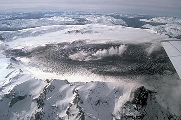
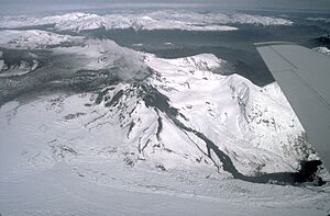
Aerial photo from 1991
|
|
| Highest point | |
| Elevation | 1,905 m (6,250 ft) |
| Naming | |
| Etymology | Named after Francisco Hudson |
| Geography | |
| Parent range | Andes |
| Geology | |
| Mountain type | Caldera |
| Last eruption | 2011 |
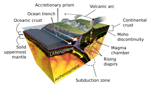
Hudson Volcano (also called Cerro Hudson or Monte Hudson in Spanish) is a very active volcano in the Andes Mountains of Chile. It last erupted in 2011. This volcano was created when the Nazca Plate (an oceanic plate) slid underneath the South American Plate (a continental plate). This process is called subduction.
Hudson Volcano is shaped like a large, ice-filled bowl, about 10 kilometers (6 miles) wide. This bowl is called a caldera. A big glacier called Huemules flows out from its side. Hudson has erupted many times over thousands of years, sending out ash and rocks.
Some of its biggest eruptions happened around 17,300 years ago (H0), 7,750 years ago (H1), 4,200 years ago (H2), and in 1991 (H3). The H1 eruption was one of the strongest in South America during the last 10,000 years. A smaller eruption also happened in 1971. These eruptions, especially H1 and H3, greatly affected people and animals in Patagonia and Tierra del Fuego. For example, the 1991 eruption covered large areas of Chile and Argentina with ash, harming farm animals and causing economic problems. Ash from this eruption even reached Antarctica.
Contents
Where is Hudson Volcano?
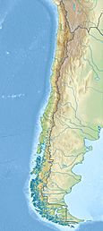
Hudson Volcano is located in the Andes Mountains in southern Chile. It is northwest of a large lake called Lago Buenos Aires. The volcano is named after Francisco Hudson, a Chilean Navy captain. It is also sometimes called Cerro de los Ventisqueros.
The volcano is in the Aysen Region of Chile. Because it is far away and surrounded by thick forests, scientists did not fully recognize it as a volcano until 1970. The closest towns are Puerto Aysen, about 58 kilometers (36 miles) away, and Coihaique, about 75 kilometers (47 miles) away. A main highway, the Carretera Austral, passes about 30 kilometers (19 miles) from the volcano. Farmers live in the valleys around the volcano.
Hudson's Place in the Andes
The Andes Mountains have a long chain of volcanoes called the Andean Volcanic Belt. This belt is divided into four main parts. Hudson Volcano is in the southern part of the Southern Volcanic Zone. Further south, there is a long gap without active volcanoes before the Austral Volcanic Zone begins.
What Does Hudson Volcano Look Like?
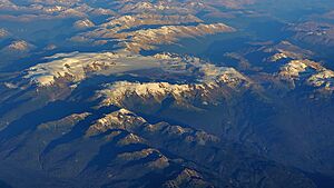
Hudson Volcano is a large, ice-filled caldera about 10 kilometers (6 miles) wide. It rises about 1,000 to 1,200 meters (3,300 to 3,900 feet) above the land around it. The highest point of the volcano is 1,905 meters (6,250 feet) tall. The volcano looks worn down, with deep valleys carved into its sides.
The caldera is filled with about 2.5 cubic kilometers (0.6 cubic miles) of ice, which is about 40 meters (130 feet) thick. This ice forms a large glacier called Ventisquero de los Huemules, which is about 11 kilometers (7 miles) long. This glacier is the source of the Huemules River. The glacier is often covered in ash, making it look like a lava flow from above.
A small crater lake formed in the ice after the 1991 eruption. The 1971 eruption destroyed most of the ice inside the caldera, but it grew back by 1979. During the 1991 eruption, new cones and small lakes formed in the ice. Since then, the glaciers on Hudson have been shrinking. When the volcano erupts, hot ash and lava can melt the ice. Many rivers and hot springs start on Hudson Volcano.
How Hudson Volcano Formed
Hudson Volcano exists because of plate tectonics. Off the coast of South America, the Nazca Plate is slowly sliding underneath the South America Plate. This movement is called subduction. It happens at a speed of about 9 centimeters (3.5 inches) per year. This process creates the volcanoes in the Southern Volcanic Zone, including Hudson.
The land under Hudson Volcano is made of a very long rock formation called the North Patagonian Batholith. This formation is about 1,000 kilometers (620 miles) long and made of different types of intrusive rocks. The Earth's crust under Hudson is about 30 kilometers (19 miles) thick.
Volcanoes in this region are also affected by large cracks in the Earth's surface called faults. One important fault system, the Liquiñe-Ofqui Fault Zone, runs parallel to the volcanic belt. It moves about 1 to 2 centimeters (0.4 to 0.8 inches) per year in this area.
Magma Inside Hudson
Hudson Volcano has erupted many different kinds of volcanic rocks. The magma (melted rock) that feeds Hudson comes from deep within the Earth. It collects in underground chambers about 6 to 24 kilometers (4 to 15 miles) deep. Before a big eruption, the magma moves into shallower chambers, just a few kilometers below the surface.
Sometimes, magma can rise directly to the surface through faults, creating smaller volcanic cones around the main caldera.
Climate and Nature Around Hudson
The climate around Hudson is oceanic, meaning it's mild and wet. Average yearly temperatures are about 8 to 10 degrees Celsius (46 to 50 degrees Fahrenheit). The coast gets a lot of rain, up to 3,000 millimeters (120 inches) per year. In the Andes, it can rain even more, up to 10,000 millimeters (390 inches) per year.
The region is covered by temperate rainforests with conifers, broadleaf trees, and beech trees. In coastal areas, you can find Magellanic moorlands with cushion plants. To the east, the landscape changes to the Patagonian steppe with grasses and shrubs.
Hudson's Eruption History
Hudson Volcano has been active for over a million years. Scientists study layers of ash, called tephra, to understand its past eruptions. These ash layers are found in the ground, in lakes, and even in ice cores from Antarctica.
During the last ice age, Hudson was covered by a thick ice sheet. When this ice melted about 17,900 years ago, it may have caused more volcanic activity. The melting ice would have reduced pressure on the magma systems, making eruptions more likely.
Major Holocene Eruptions
Hudson has had many powerful eruptions over the last 10,000 years (the Holocene period). Three of these were among the largest in South America. Big eruptions happen about every 3,870 years, but their size has decreased over time. Smaller eruptions occur every 500 to 1,000 years. Hudson is the most active volcano in Patagonia, with 55 eruptions in the last 22,000 years.
The Hudson caldera likely formed gradually during the Holocene. Outside the caldera, you can find deposits from pyroclastic falls (ash and rock fragments falling from the sky) and lahars (volcanic mudflows).
| Approximate Date (Years Ago) | Eruption Name | Notes |
|---|---|---|
| 17,300–17,440 | H0 eruption | Largest known eruption, produced over 20 cubic kilometers of ash. |
| 7,750 | H1 eruption | Largest Holocene eruption in the southern Andes, VEI 6. Ash reached Tierra del Fuego and West Antarctica. |
| 4,200 | H2 eruption | Smaller than H1, but larger than H3. Ash spread mainly to the east. |
| 1971 AD | VEI 3-4. Caused lahars and ashfall. | |
| 1991 AD | H3 eruption | Second-largest historic eruption in Chile, VEI 5. Ash reached Antarctica and Australia. |
| 2011 AD | Latest eruption, caused lahars and ash columns. |
Significant Eruptions and Recent Activity
H0 Eruption: 17,300–17,440 Years Ago
The H0 eruption was the biggest known eruption of Hudson. It happened during the late ice age and released more than 20 cubic kilometers (4.8 cubic miles) of ash. This eruption might have started the formation of the caldera. The ash spread mainly to the northeast, covering areas up to 400 kilometers (250 miles) away.
H1 Eruption: 7,750 Years Ago
The H1 eruption was the largest eruption of Hudson during the Holocene. It was incredibly powerful, reaching a volcanic explosivity index (VEI) of 6. This eruption produced about 18 cubic kilometers (4.3 cubic miles) of rock and ash. It likely caused the caldera to collapse further.
Ash from H1 spread far to the south-southeast, covering all of southern Patagonia and parts of Tierra del Fuego. It was found in lakes, peat bogs, and even in West Antarctica. This eruption devastated the environment, burying plants and harming animals. It also had a big impact on human populations, possibly causing people to change their way of life or even abandon some areas.
Impact on Tierra del Fuego
The H1 eruption had a severe impact on Tierra del Fuego. Ash layers up to 20 centimeters (8 inches) thick covered the island. This buried vegetation and greatly affected animals. It may have caused major changes for the hunter-gatherers living there, possibly leading to a shift towards relying on coastal food sources.
H2 Eruption: 4,200 Years Ago
The H2 eruption happened about 4,200 years ago. It was smaller than H1 but still very powerful, reaching a VEI of 6. The ash from this eruption spread mainly to the east and southeast. Evidence from archaeological sites suggests that people in areas like Los Toldos left after this eruption.
H3 Eruption: 1991 AD
The 1991 eruption, known as H3, was a major event. It started on August 8, 1991, with tremors and a phreatomagmatic eruption (an eruption caused by magma interacting with water or ice). This created a 4-kilometer (2.5-mile) long crack and a 400-meter (1,300-foot) wide crater. A few days later, a powerful Plinian eruption began, forming an 800-meter (2,600-foot) wide crater.
This eruption was the second-largest in Chile's recorded history and one of the biggest worldwide in the 20th century, with a VEI of 5. It sent an ash column 12 kilometers (7.5 miles) high into the sky. A 4-kilometer (2.5-mile) long lava flow melted part of the ice cap. A large lahar (mudflow) flowed 40 kilometers (25 miles) down the Huemules River to the Pacific Ocean.
More than 4 cubic kilometers (1 cubic mile) of ash fell over a huge area in Chile and Argentina, reaching as far as the Falkland Islands and South Georgia. The ash buried plants, roads, and contaminated water. It harmed farm animals, causing many to die, and caused breathing and eye problems for people. The eruption led to serious economic problems and a decrease in population in the affected region.
Ash Spread Across Continents
The ash cloud from the 1991 eruption traveled far. Winds carried it towards Antarctica, where it was found in snow at the South Pole and in ice cores. Aircraft even spotted the ash cloud as far away as Melbourne, Australia. Particles from Hudson's eruption have even been found in ice on Mount Everest in the Himalaya.
The Hudson eruption happened in the same year as the 1991 eruption of Mount Pinatubo. While Pinatubo's eruption had a global climate impact, Hudson's eruption caused significant ozone loss over Antarctica and had similar effects in the Southern Hemisphere.
Other Recent Activity
There are reports of earlier eruptions in the late 1800s, with one confirmed in 1891.
On August 12, 1971, tremors signaled a new eruption. It lasted three days and had a VEI of 3 to 4. An ash column rose 5 to 12 kilometers (3 to 7.5 miles) high, sending ash eastward into the South Atlantic Ocean. A lahar flowed down the Huemules River, killing at least five people and damaging homes and farms.
The most recent eruption was in October 2011. It was preceded by increased activity in the volcano's hot springs and earthquakes. The eruption began on October 26 and ended on November 1. Ash columns rose almost 1 kilometer (0.6 miles) high. Lahars flowed down several valleys, likely caused by ice melting due to the volcano's heat. Chilean authorities evacuated about 140 people from the area for safety.
Between 1991 and 2008, the ground at Hudson Volcano slowly rose, suggesting new magma was entering the volcano's system. Today, small earthquakes happen under Hudson, showing that the volcano is still active.
Volcanic Hazards
The 1991 eruption highlighted the dangers from Hudson and other volcanoes in Patagonia. About 84,000 people live within 50 kilometers (31 miles) of Hudson. Even though the area is not densely populated, ashfall can severely impact farming and animal raising.
Most eruptions cause ash to fall around the volcano. More powerful eruptions can produce pyroclastic flows (fast-moving currents of hot gas and volcanic debris) outside the caldera. Mudflows, caused by melting ice or ash erosion, have occurred in the Huemules and Ibáñez valleys.
After the 1991 eruption, Argentina and Chile started programs to monitor volcanoes. Chile's geological service published a hazard map in 2014. This map shows areas at risk from lahars, lava flows, pyroclastic falls, and volcanic bombs. The highest risk areas are within the caldera and its immediate surroundings, especially the Huemules and Sorpresas valleys.
 | Delilah Pierce |
 | Gordon Parks |
 | Augusta Savage |
 | Charles Ethan Porter |


