
Irapuato facts for kids
Quick facts for kids
Irapuato
|
|||
|---|---|---|---|
|
City and municipality
|
|||
|
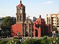
Clockwise from upper left: Templo del Hospitalito, Centro Histórico, Zona Dorada , Museo de la Ciudad, Templo de Santiaguito and Catedral de Nuestra Señora de la Soledad.
|
|||
|
|||
| Nickname(s): | |||
| Motto(s): | |||

Irapuato
Location in Guanajuato

Irapuato
Location in Mexico
|
|||
| Country | |||
| State | |||
| Municipality | |||
| Founded | February 15, 1547 | ||
| Founded as | Congregación de San Marcos Irapuato | ||
| Founded by | Vasco de Quiroga | ||
| Area | |||
| • City | 69.68 km2 (26.90 sq mi) | ||
| • Municipality | 851 km2 (329 sq mi) | ||
| Elevation | 1,724 m (5 676 ft) | ||
| Population
(2020 census)
|
|||
| • City | 452,090 | ||
| • Density | 6,488.1/km2 (16,804.1/sq mi) | ||
| • Municipality | 592,953 | ||
| • Municipality density | 696.8/km2 (1,804.6/sq mi) | ||
| Demonym(s) | Irapuatense, Fresero | ||
| Time zone | UTC-6 (Central Standard Time) | ||
| • Summer (DST) | UTC-5 (Central Daylight Time) | ||
| ZIP code |
36590 - 36899
|
||
| Area code(s) | 462 | ||
| Website | Official Website of the City of Irapuato: http://www.irapuato.gob.mx | ||
| Average temperature 19°C | |||


Irapuato is a city and municipality in Mexico. It is located in the central part of the state of Guanajuato. The city sits at the foot of the Arandas Hill, near the Silao and Guanajuato rivers. It is about 1,724 meters (5,676 feet) above sea level.
Irapuato is the second largest city in Guanajuato, after León. In 2005, the city had a population of 342,561 people. The whole municipality, which includes smaller towns, had about 529,440 people. The municipality covers an area of 851 square kilometers (329 sq mi).
Historically, Irapuato was known for its agriculture. It is famous for its delicious strawberries. People also raise pigs and cattle here. Today, Irapuato is an important center for trade and transportation. It also has factories that make cars and chemicals.
Contents
History of Irapuato
Early Settlements and Ancient Times
Long ago, around 1200 AD, the area where Irapuato is now was home to the Chichimecas. These were groups of people who moved around, hunting and gathering food.
Later, the Purépecha group took over the region. They started building a permanent settlement. They built homes in their unique style and made pottery. They also began farming the land. They called this place Xiriquitzio or Iriquitzio. The Spanish later called it "Jiricuato," which means "the place with houses."
However, the Purépecha Empire eventually declined. This led to the settlement being left empty for a while. The Chichimecas then returned to live there.
Spanish Arrival and Silver Discovery
In the 1500s, something big happened. A lot of silver was found in what is now the city of Guanajuato. This discovery brought many Spanish settlers to the area. They came looking for new opportunities.
The Great Flood of 1973
On August 18, 1973, Irapuato faced a terrible event. A dam broke, sending a huge wall of water into the city. The water was about 2 meters (7 feet) high. Thousands of homes were destroyed. Many people were left stuck on roofs and high places for days. This event caused a lot of damage and sadness.
Geography and Climate
Irapuato's Location and Weather
Irapuato has a humid subtropical climate. This means it has warm, wet summers and mild, drier winters. The average temperature is about 20°C (68°F). Most of the rain falls between June and September. The city is located 1,724 meters (5,676 feet) above sea level.
| Climate data for Irapuato | |||||||||||||
|---|---|---|---|---|---|---|---|---|---|---|---|---|---|
| Month | Jan | Feb | Mar | Apr | May | Jun | Jul | Aug | Sep | Oct | Nov | Dec | Year |
| Record high °C (°F) | 31.0 (87.8) |
35.0 (95.0) |
35.0 (95.0) |
38.0 (100.4) |
42.1 (107.8) |
38.0 (100.4) |
35.0 (95.0) |
32.0 (89.6) |
34.0 (93.2) |
33.5 (92.3) |
33.0 (91.4) |
32.0 (89.6) |
42.1 (107.8) |
| Mean daily maximum °C (°F) | 24.4 (75.9) |
26.3 (79.3) |
29.1 (84.4) |
31.1 (88.0) |
32.3 (90.1) |
30.2 (86.4) |
28.2 (82.8) |
28.0 (82.4) |
27.5 (81.5) |
27.1 (80.8) |
26.3 (79.3) |
24.9 (76.8) |
28.0 (82.4) |
| Daily mean °C (°F) | 15.2 (59.4) |
16.7 (62.1) |
19.4 (66.9) |
21.8 (71.2) |
23.7 (74.7) |
23.2 (73.8) |
21.6 (70.9) |
21.4 (70.5) |
20.9 (69.6) |
19.5 (67.1) |
17.5 (63.5) |
15.9 (60.6) |
19.7 (67.5) |
| Mean daily minimum °C (°F) | 6.0 (42.8) |
7.1 (44.8) |
9.6 (49.3) |
12.5 (54.5) |
15.1 (59.2) |
16.1 (61.0) |
15.1 (59.2) |
14.9 (58.8) |
14.3 (57.7) |
11.8 (53.2) |
8.7 (47.7) |
6.9 (44.4) |
11.5 (52.7) |
| Record low °C (°F) | −3.0 (26.6) |
−2.5 (27.5) |
0.0 (32.0) |
4.0 (39.2) |
5.0 (41.0) |
10.0 (50.0) |
6.5 (43.7) |
9.0 (48.2) |
4.8 (40.6) |
2.0 (35.6) |
0.0 (32.0) |
−2.0 (28.4) |
−3.0 (26.6) |
| Average precipitation mm (inches) | 11.5 (0.45) |
4.6 (0.18) |
3.8 (0.15) |
10.0 (0.39) |
30.5 (1.20) |
116.5 (4.59) |
164.3 (6.47) |
141.7 (5.58) |
105.9 (4.17) |
37.9 (1.49) |
9.6 (0.38) |
8.2 (0.32) |
644.5 (25.37) |
| Average precipitation days (≥ 0.1 mm) | 1.6 | 1.2 | 1.1 | 2.0 | 4.8 | 10.8 | 15.3 | 14.1 | 10.1 | 4.3 | 1.5 | 1.8 | 68.6 |
| Source: Servicio Meteorologico Nacional | |||||||||||||
Transportation in Irapuato
Getting to Irapuato by Air
Irapuato is close to the Del Bajío International Airport. This airport is also known as Guanajuato International Airport (IATA: BJX). It is located in Silao, about 25 minutes from Irapuato.
The airport handles flights from many cities. You can fly to Irapuato from places like Los Angeles, Houston, Dallas, Mexico City, and Guadalajara. It is an important airport for connecting flights from Mexico City to the United States.
Major Roads and Highways
Several important highways pass through or near Irapuato. These roads connect the city to other parts of Mexico.
 Mexican Federal Highway 45 connects Ciudad Juárez in Chihuahua to Panales in Hidalgo.
 Mexican Federal Highway 90 runs from Irapuato, Guanajuato, to Zapotlanejo, Jalisco.
 Mexican Federal Highway 43 links Salamanca, Guanajuato, to Morelia, Michoacán.
 Mexican Federal Highway 110 goes from Armería, Colima, to Xoconostle, Guanajuato.
Education in Irapuato
Irapuato has several places for higher learning. There are private universities, like a branch of the University of the Incarnate Word. This is a Catholic university from the United States.
The city also has a public university called the Higher Technological Institute of Irapuato (ITESI).
For advanced studies, Irapuato is home to a research center. This is part of the Center for Advanced Research and Studies. They focus on plant biotechnology and genetics. There is also a new National Center of Plant Genomics.
Sports in Irapuato
Irapuato has a local football (soccer) team. They are called Irapuato FC, and their nickname is La Trinca.
Sports Venues and Stadiums
The city has several places where sports and events take place:
- Estadio Sergio Leon Chavez
- Plaza de Toros
- Parque Irekua
- Golf Club Santa Margarita
Notable People from Irapuato
Many talented people come from Irapuato. Here are a few:
- Amalia Macías – a singer and actress who performed in Europe.
- Enrique del Moral – a famous architect.
- Silvia Navarro – an actress.
- Natalia Guerrero – an actress.
- Carolina Miranda - an actress.
- Carlos Cordero – an athlete who ran for Mexico in the 2012 London Olympics.
- Samuel Ruiz – a Catholic leader.
- Mario Castañeda – a Mexican voice actor.
- Chucho Navarro – a founding member of the music group Trio Los Panchos.
- Roberto Alvarado – a professional soccer player for Cruz Azul and the Mexico National Team.
- Claudio González – a professional soccer player for Club Leon.
- Óscar Razo – a professional soccer player who played for Club Atlas.
- Francisco Rotllán – a professional soccer player who played for Mexico in the 1992 Summer Olympics.
- Sergio Ávila – a professional soccer player who played for Chivas de Guadalajara.
- José Antonio Patlán – a professional soccer player who played for Chivas de Guadalajara.
- Juan Zaragoza – a soccer player.
Images for kids
-

Mural depicting Miguel Hidalgo y Costilla and the Mexican Independence movement.
-
Hospitalito Church
-

Aguas Danzarinas Fountain
-
Irapuato's Hidalgo Garden
-
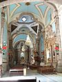
Templo de la Soledad
-
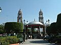
Plaza de Los Fundadores
-
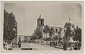
Tercera Orden's Church, circa 1907. Photo courtesy SMU


Sister Cities
Irapuato has "sister city" relationships with several cities around the world. This means they share cultural and economic ties.
 Aguascalientes, Aguascalientes, Mexico
 Green Bay, Wisconsin, United States
- Houston, Texas, United States
- Chula Vista, California, United States
- Laredo, Texas, United States
 Marianao, Havana, Cuba
- McAllen, Texas, United States
 Murcia, Murcia, Spain
See also
 In Spanish: Irapuato para niños
