
Irrawaddy River facts for kids
Quick facts for kids Irrawaddyဧရာဝတီမြစ် |
|
| River | |
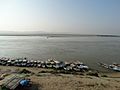
 Bird's eye view of the river
|
|
| Country | Myanmar |
|---|---|
| Tributaries | |
| - left | Chindwin, Mu |
| - right | Myitnge |
| Cities | Myitkyina, Mandalay, Bhamo |
| Source | Mali River |
| Secondary source | N'Mai River |
| Mouth | Andaman Sea |
| - elevation | 0 m (0 ft) |
| Length | 2,210 km (1,373 mi) |
The Irrawaddy River, also called the Ayeyarwady River, is the longest and most important river in Myanmar. It flows from the northern mountains all the way south to the Andaman Sea. This huge river is like a busy highway for boats and helps many people in Myanmar. It starts where two rivers, the N'mai and Mali, meet. The area that drains into the Irrawaddy River is about 404,200 square kilometers, covering a big part of Myanmar.
Contents
The Irrawaddy Delta: A Fertile Land
The delta of the Irrawaddy River is a wide, flat area where the river splits into many smaller streams before reaching the sea. It starts about 93 kilometers north of the city of Hinthada. The westernmost stream is the Pathein (Bassein) River, and the easternmost is the Yangon River. The land in the delta is low, but it is not completely flat. The soil here is very fine silt, which is great for growing plants.
Many people live in the delta region. Because the land can be as low as 3 meters above sea level, it is a very important area for growing rice.
In May 2008, a powerful storm called Cyclone Nargis hit the delta. It caused a lot of damage and left many people without homes.
The delta region gets about 2,500 millimeters of rain each year. Most of this rain falls during the monsoon season, which is from May to November.
Amazing Animals and Plants of the Irrawaddy

Scientists are still making a full list of all the different types of fish in the Irrawaddy River. In 2008, it was thought that between 119 and 195 species of fish live here and nowhere else in the world!
One of the most famous animals in the river is the Irrawaddy dolphin. This dolphin is considered a vulnerable species, which means it is at risk of becoming endangered. In 2016, officials reported that only 62 of these dolphins were left in Myanmar.
The areas along the river have several different ecoregions, each with its own unique plants and animals.
Northern Mountains: Where the River Begins
The Irrawaddy River starts where the Nmai and Mali rivers join. Both of these rivers begin high up in remote mountains near the border with Tibet. In this area, rain falls all year, but mostly in the summer. The valleys and lower hills are covered with thick evergreen rainforests. Higher up, above 900 meters, you can find forests of oak and pine trees. Even higher, above 1,800 meters, there are forests of colorful rhododendrons. Above 2,400 meters, you'll see evergreen conifer forests.
The Central Basin and Lowlands: Teak Forests and Wildlife
The central part of the river basin does not get much rain. However, the air is always humid, which is good for plant life. This area is mostly flat plains. The forests here are mostly filled with teak trees, which are known for their strong wood. Many of the natural habitats in this area have been changed for farming. The wildlife includes many birds, small mammals, and reptiles like the huge Burmese python.
Irrawaddy Delta Area: Mangroves and Swamps
The delta area has mangroves and freshwater swamp forests. It is a very fertile area, meaning the soil is rich and good for growing things. The upper and central parts of the delta are mostly used for farming, especially rice. The southern part of the delta becomes the Myanmar Coast mangroves. This area has marshes with oxbow lakes (U-shaped lakes), islands, and many streams.
Many types of birds live in the delta. These include the great cormorant, different kinds of ducks and geese, and the red junglefowl.
Large mammals found here include the Malayan sambar deer, Indian hog deer, and wild boar. Other large mammals are present in smaller numbers, such as the leopard, Bengal tiger, crab-eating macaque, wild dog, and otters.
The saltwater crocodile can be found in the southern part of the delta. There are also five species of sea turtle that are known to lay their eggs in Myanmar.
Major Rivers Joining the Irrawaddy
The Irrawaddy River has five main tributaries. Tributaries are smaller rivers that flow into a larger river. The rivers that join the Irrawaddy, from north to south, are:
- Taping River
- Shweli River
- Myitnge River
- Mu River
- Chindwin River
Cities and Towns Along the Irrawaddy

The river flows through or past many important cities and towns, including:
- Myitkyina
- Bhamo
- Katha
- Tagaung
- Kyaukmyaung
- Mandalay
- Sagaing
- Yenangyaung
- Chauk
- Bagan
- Nyaung-U
- Magway
- Pyay
- Hinthada
- Pantanaw
Images for kids
-
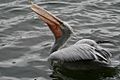
The spot-billed pelican was once widespread in Asia, but is not known to breed in Myanmar anymore.
-
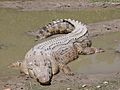
Although the saltwater crocodile is not common in Myanmar, they do live in and near reserved forests. Attacks on people still occur in the Irrawaddy river.
-
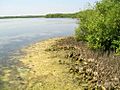
A mangrove forest system along the coast
-
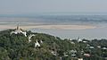
Irrawaddy River from Sagaing Hill, Sagaing
-
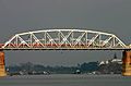
The Ava Bridge near Sagaing, rebuilt in 1954 after the wartime destruction of the original bridge built in 1934, was the only bridge over the Irrawaddy until 1998.
-
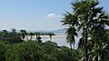
The shores of Irrawaddy River near Nyaung-U, Bagan
-
River Irrawaddy with Mandalay Hill on the east bank
-
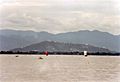
Travelling on the great river
-
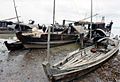
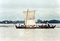
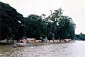
Traditional rivercraft on the Irrawaddy
-
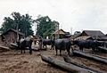
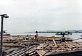
Buffalo pulling logs from the Irrawaddy at Mandalay
-
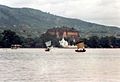
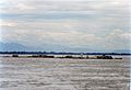
The great river at Mingun
-
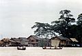
An island village on the Irrawaddy stays above water on stilts during the monsoons
-
Bamboo rafts by the Irrawaddy
-
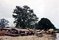
Market on the west bank at Mingun
-
Bamboo raft sailing down the Irrawaddy
-
Woman sailing in small boat along the west bank at Mingun
-
Irrawaddy river near Bu Paya
.jpg)
.jpg)


See also
 In Spanish: Río Irawadi para niños
