Isle La Motte facts for kids
Quick facts for kids
Isle La Motte
Île La Motte (French)
|
|
|---|---|

The Head at the south end of Isle La Motte
|
|

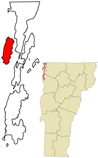
Location in Grand Isle County and the state of Vermont
|
|
| Country | United States |
| State | Vermont |
| County | Grand Isle |
| Named for | Pierre La Motte |
| Area | |
| • Total | 16.7 sq mi (43.2 km2) |
| • Land | 7.9 sq mi (20.4 km2) |
| • Water | 8.8 sq mi (22.7 km2) |
| Elevation | 95 ft (29 m) |
| Population
(2020)
|
|
| • Total | 488 |
| • Density | 62/sq mi (23.9/km2) |
| Time zone | UTC-5 (Eastern (EST)) |
| • Summer (DST) | UTC-4 (EDT) |
| ZIP code |
05463
|
| Area code(s) | 802 |
| FIPS code | 50-35875 |
| GNIS feature ID | 1457978 |
Isle La Motte (which means Île La Motte in French) is a special island in Lake Champlain. It's located in northwestern Vermont, United States. The island is about 7 miles (11 km) long and 2 miles (3 km) wide. It sits near where Lake Champlain flows into the Richelieu River. Isle La Motte is set up like a New England town within Grand Isle County. In 2020, about 488 people lived there.
The island gets its name from Pierre La Motte, a French soldier. He built a military fort on the island way back in 1666. Many more people visit or live on the island during the summer months. You can find several interesting places on the island, like Fort Sainte Anne, Saint Anne's Shrine, the Methodist Episcopal Church of Isle La Motte, and the Isle La Motte Lighthouse. There are also the Fisk Quarry and Goodsell Ridge Preserves, which are important for geology, and the Isle La Motte Elementary School.
Contents
Island History and Early Settlements
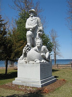
A long time ago, on July 9, 1609, a famous explorer named Samuel de Champlain landed on this island.
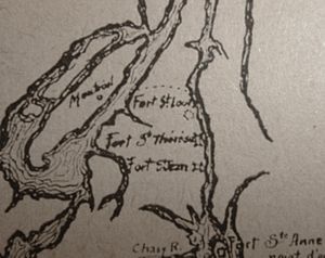
Later, in 1665, the French started building forts along the Richelieu River. These forts were meant to protect New France from the Iroquois people. Some of these forts were Fort Richelieu, Fort Chambly, and Fort Sainte Thérèse.
Four groups of soldiers from the Carignan-Salières Regiment came from Quebec City. They were led by Captain Pierre La Motte. Their job was to build more forts further south. They also made a path connecting Fort Sainte Thérèse and Fort Saint-Louis.
In 1666, two more forts were added: Fort Saint-Jean and Fort Sainte Anne. Fort Sainte Anne was built right here on Isle La Motte. This fort also included Saint Anne's Shrine, a special chapel. Both the fort and the chapel were named after Saint Anne. In 1668, the bishop of Quebec, François de Laval, visited Isle La Motte. He baptized many Iroquois people into Christianity. Even after the fort was no longer used, the shrine continued to hold church services. Fort Sainte Anne was the very first European settlement in what we now call Vermont.
Fort Sainte Anne was the most exposed to attacks. About 300 French soldiers stayed at the fort for four years. After that, the troops went back to Québec, but not before they destroyed the fort.
In 1746, a group of Mohawks, led by Hendrick Theyanoguin, attacked some Frenchmen at Isle La Motte. This happened after they had met with the Governor of New France in Montreal. After this, the Mohawks also raided areas along the St. Lawrence River in 1747.
Life on the Island Through the Years
In the mid-1800s, Isle La Motte was a busy place with orchards, vineyards, and dairy farms. During the warmer months, people used a ferry to get to the mainland. In winter, they could walk or use wagons across the ice. For a short time in November 1802, the island was called "Vineyard." However, its original name, Isle La Motte, was brought back in November 1830.
In 1878, the town was officially set up to build a bridge to Alburgh. This bridge was finished in 1882.
Fisk Farm on the island was a famous spot. In August 1897, President William McKinley spoke there. Later, in September 1901, Vice President Theodore Roosevelt visited. He learned about the shooting of President McKinley while he was there. President McKinley sadly died later.
Amazing Geology and Quarrying History
The island of Isle La Motte has a truly ancient past! It was formed about 480 million years ago. This happened during a time called the Ordovician Period. Back then, the area was a shallow, warm ocean, similar to where Morocco is today. At that time, there was almost no life on dry land, only simple plants like mosses and algae. Most living things were in the oceans. The air had much more carbon dioxide than it does now, and high sea levels covered a lot of the continents.
Isle La Motte is home to one of the oldest known metazoan reefs. A reef is like an underwater city built by tiny sea creatures. This ancient reef, called the Chazy Fossil Reef, once stretched for a thousand miles from Quebec to Tennessee. Today, only a few parts of it remain. In 2009, the island's fossil reefs were named a National Natural Landmark.
The creatures that built these reefs long ago included bryozoa, stromatolites, stromatoporoids, sponges, and algae. Other sea animals like cephalopods (like squids), gastropods (snails), crinoids (sea lilies), and trilobites (ancient sea bugs) also lived there. If you visit the old quarries on the island today, you can still see fossils of these ancient snails!
The island also has black limestone from the Chazy Formation. This stone was dug out of quarries on the island. The oldest quarry, behind Fisk Farm, started working as early as 1832.
This special limestone is made of calcite and fossils of sea creatures. It's so dark that in the 1700s and 1800s, people called it "black marble." This "black marble" was used to build important buildings like the U.S. Capitol building and the National Gallery of Art. You can still see buildings made of this stone on the island today, including the Isle La Motte Public Library, the Isle La Motte Methodist Church, and the Isle La Motte Historical Society.
Population and Island Life
| Historical population | |||
|---|---|---|---|
| Census | Pop. | %± | |
| 1800 | 135 | — | |
| 1810 | 623 | 361.5% | |
| 1820 | 312 | −49.9% | |
| 1830 | 459 | 47.1% | |
| 1840 | 435 | −5.2% | |
| 1850 | 476 | 9.4% | |
| 1860 | 564 | 18.5% | |
| 1870 | 497 | −11.9% | |
| 1880 | 505 | 1.6% | |
| 1890 | 551 | 9.1% | |
| 1900 | 608 | 10.3% | |
| 1910 | 510 | −16.1% | |
| 1920 | 385 | −24.5% | |
| 1930 | 352 | −8.6% | |
| 1940 | 335 | −4.8% | |
| 1950 | 295 | −11.9% | |
| 1960 | 238 | −19.3% | |
| 1970 | 262 | 10.1% | |
| 1980 | 393 | 50.0% | |
| 1990 | 408 | 3.8% | |
| 2000 | 488 | 19.6% | |
| 2010 | 471 | −3.5% | |
| 2020 | 488 | 3.6% | |
| U.S. Decennial Census | |||
The town of Isle La Motte covers a total area of about 43.2 square kilometers (16.7 square miles). About 20.4 square kilometers (7.9 square miles) of this is land, which is the island itself. The rest, about 22.7 square kilometers (8.8 square miles), is water.
According to the 2010 census:
- The island had 471 residents.
- There were 204 households.
- The average household had 2.31 people.
- The average family had 2.77 people.
- The median age of people on the island was 45.6 years.
- About 20.4% of the population was under 18 years old.
For transportation, people can use nearby airports like Burlington International Airport and Plattsburgh International Airport.
See also
 In Spanish: Isla La Motte para niños


