Kāpiti Coast District facts for kids
Quick facts for kids
Kāpiti Coast District
|
|
|---|---|
|
Territorial authority district
|
|

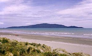
Looking across Waikanae Beach to Kapiti Island
|
|
 |
|
| Country | New Zealand |
| Region | Wellington |
| Wards | Ōtaki Waikanae Paraparaumu Paekākāriki-Raumati |
| Community Boards | Paekākāriki Community Board Paraparaumu Community Board Raumati Community Board Waikanae Community Board Ōtaki Community Board |
| Electorates | Mana (general) Ōtaki (general) Te Tai Hauāuru (Māori) |
| Area | |
| • Territorial | 731.52 km2 (282.44 sq mi) |
| • Urban | 76.69 km2 (29.61 sq mi) |
| • Rural | 654.83 km2 (252.83 sq mi) |
| Population
(June 2023)
|
|
| • Territorial | 58,400 |
| • Density | 79.83/km2 (206.77/sq mi) |
| Time zone | UTC+12 (NZST) |
| • Summer (DST) | UTC+13 (NZDT) |
| Postcode(s) |
5032, 5034, 5036, 5381, 5391, 5512, 5573, 5581, 5582, 5583
|
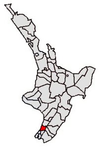
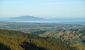
The Kāpiti Coast District is a special area in the Wellington Region of New Zealand. It's located in the lower North Island, about 50 kilometers (31 miles) north of Wellington City. The district gets its name from Kapiti Island, a large island about 5 kilometers (3 miles) off the coast.
Most people in the district live in a line of towns along State Highway One. These towns include Ōtaki, Te Horo, Waikanae, Paraparaumu, Raumati Beach, Raumati South, and Paekākāriki. Paraparaumu is the biggest town and the main center for shops and local government. Many farms and gardens are found along the highway between these towns. The eastern part of the district is covered by the Tararua Forest Park, which has tall mountains over 1500 meters (4900 feet) high.
Contents
- What is the Geography of Kāpiti Coast?
- What is the History of Kāpiti Coast?
- What is the Name and Meaning of Kāpiti?
- How is Kāpiti Coast Governed?
- What is the Population of Kāpiti Coast?
- What is the Economy and Transport like in Kāpiti Coast?
- What are the Attractions in Kāpiti Coast?
- How is Kāpiti Coast Connected to Film and Television?
- What Sports are Popular in Kāpiti Coast?
- What News Media are in Kāpiti Coast?
What is the Geography of Kāpiti Coast?

The Kāpiti Coast District stretches from Ōtaki in the north to Paekākāriki in the south. It includes towns like Te Horo, Waikanae, Paraparaumu, Raumati Beach, and Raumati South. Smaller places like Maungakotukutuku, Otaihanga, and Peka Peka are also part of it. The district goes from the Tasman Sea coast all the way to the top of the Tararua Range mountains. Kapiti Island, a famous island off the coast, is also part of the district.
Even though many people from Kāpiti Coast travel to Wellington for work, it's not usually seen as part of the main Wellington city area. However, it's a very popular place for people from Wellington to visit on weekends. The town of Paraparaumu, which is central to the district, is about 55 kilometers (34 miles) north of Wellington.
The area has a mild climate. This means it has warm summers and gentle winters. There are no extreme hot or cold weather periods.
What is the History of Kāpiti Coast?
Early History and European Settlement
A Māori chief named Te Rauparaha set up a base on Kapiti Island. From there, he launched attacks on other tribes during the Musket Wars in the early 1800s. Around this time, Europeans started whaling in the area. In 1839, William Wakefield from the New Zealand Company came to buy land for European settlers. Te Rauparaha sold him land in the Nelson and Golden Bay areas.
Many Europeans only started settling on the Kāpiti Coast after the Wellington and Manawatu Railway Company (WMR) built a railway line. This line connected Wellington to Longburn, near Palmerston North, and opened in 1886. The last piece of track was laid at Otaihanga on the Kāpiti Coast.
Railway Development and Growth
Paekākāriki quickly became an important railway stop. Trains had to swap locomotives there because powerful engines were needed for the tough journey from Wellington to Paekākāriki. Lighter engines were better for the flatter land north of Paekākāriki. In 1908, the New Zealand Railways Department bought the WMR line. It became part of the main railway line for the North Island.
In 1940, the railway section from Wellington to Paekākāriki was electrified. Electric trains were more powerful. This meant trains continued to swap engines at Paekākāriki. It also became the end of the Wellington commuter train line until 1983, when the line was extended to Paraparaumu. In 2011, the electric line reached Waikanae, which is now the end of the line.
World War II and Airport Development
During World War II, Queen Elizabeth Park was home to two large camps for the United States Army and Marines. US troops stayed there from 1942 to 1944 before going to fight in the Pacific.
After World War II, Wellington's main airport closed in 1947. Kapiti Coast Airport then became the main airport for the Wellington Region. In 1949, it was New Zealand's busiest airport. This helped the Kāpiti Coast grow. However, when Wellington International Airport opened in 1959, Paraparaumu Airport lost its status. Some of its land was later sold for homes.
What is the Name and Meaning of Kāpiti?
The official name is "Kapiti Coast District," but the local council uses the spelling "Kāpiti." This is because the macron (the line above the 'a') helps people say the name correctly. The name is not related to the Māori word for "cabbage," even though they look similar.
In 2010, the council started using macrons in names like Kāpiti, Ōtaki, and Paekākāriki in their documents and signs. They did this to help with pronunciation, not to change the official spelling. Sometimes, people have added or removed macrons from signs, causing a bit of a back-and-forth.
How is Kāpiti Coast Governed?
District Council
The Kāpiti Coast District Council manages the local area. It was formed in 1989. Before that, the southern parts of the district were part of Hutt County. The council is made up of a mayor and 10 councillors. They are elected by residents every three years. Two councillors represent the Paraparaumu area, and one each for Ōtaki, Paekākāriki-Raumati, and Waikanae. Five councillors are elected from across the whole district. Kapiti Island is part of the Paraparaumu area.
Community Boards
The Kāpiti Coast District Council has five local community boards. These boards represent different parts of the district:
- The Paekākāriki Community Board covers Paekākāriki and nearby areas.
- The Paraparaumu Community Board covers Paraparaumu and Otaihanga.
- The Raumati Community Board covers Raumati Beach and Raumati South.
- The Waikanae Community Board covers Waikanae and Peka Peka.
- The Ōtaki Community Board covers Ōtaki, Te Horo, and areas north of Marycrest.
These community boards speak up for their local areas. They also help manage money for community projects.
Regional Council
The Greater Wellington Regional Council is in charge of bigger decisions for the district and the wider region. This includes things like public transport, water management, and looking after the environment.
What is the Population of Kāpiti Coast?
The Kāpiti Coast District covers about 731.52 square kilometers (282.44 square miles). In 2023, it had a population of 55,914 people. This means there are about 76 people per square kilometer. The population has grown quite a lot since the 1980s. Many people from Wellington have moved here to retire.
The median age in 2023 was 48.8 years. About 16.2% of the population was under 15 years old. About 26.7% were 65 years or older.
Most people in the district are of European descent (86.6%). About 15.8% are Māori, and smaller groups include Pasifika (3.8%) and Asian (6.2%).
What is the Economy and Transport like in Kāpiti Coast?
Local Economy
The Kāpiti Coast is known for its cheeses and other products from Lindale. There are also small factories and businesses in Paraparaumu and Ōtaki. Some smaller businesses are found in Waikanae and Raumati.
Transport and Commuting
Many people who live on the Kāpiti Coast travel to Wellington for work. Transdev runs electric commuter trains on the Kapiti Line. These trains are part of the Metlink public transport system. The KiwiRail Capital Connection train also provides a service for commuters from Palmerston North to Wellington. Metlink also has regular local bus services throughout the Kāpiti Coast.
New roads have been built to make travel easier. In 2017, a new 18-kilometer (11-mile) expressway opened. This road helps State Highway 1 bypass busy towns. An extension to Ōtaki opened in 2022. Before these new roads, the old highway (now State Highway 59) was often very busy and sometimes closed due to landslides.
The district is on the main railway line of the North Island. Commuter trains serve the area as far north as Waikanae.
Airport Services
The small Kapiti Coast Airport is located between Paraparaumu and Raumati. It used to be the main airport for the Wellington region. Now, it has daily flights across Cook Strait to Nelson and Blenheim. Air Chathams also offers flights to Auckland. The airport is also used for flight training and private planes.
What are the Attractions in Kāpiti Coast?
The Kāpiti Coast region has many interesting places to visit:
- Kapiti Island is a famous landmark. It has walking trails and is home to protected native birds. You can only visit the nature reserve with approved tour groups.
- The Kapiti Coast Museum in Waikanae shows off many historical items. These include old clothes, documents, and railway equipment.
- Ngā Manu Nature Reserve is a 14-hectare (35-acre) reserve. It protects a large area of coastal swamp forest and is a great place for birdwatching.
- Ōtaki-Māori Racing Club is New Zealand's only Māori racing club. It holds horse races every year.
- Ōtaki Museum has documents, photos, and items about the history of Ōtaki.
- Queen Elizabeth Park has the Wellington Tramway Museum and coastal walking tracks.
- Paekakariki Station Museum shows local Māori history, railway items, and information about the US Marines during World War II. It is in the old Paekākāriki Railway Station building.
- Steam Incorporated is a group that restores old trains. You can see their steam engines and railway cars at "The Engine Shed" in Paekākāriki. They also run steam train trips on New Zealand's railway network.
- The Southward Car Museum in Otaihanga has one of the largest car collections in the Southern Hemisphere.
- Paekakariki Escarpment Walkway is a walking track between Paekākāriki and Pukerua Bay. It's part of the Te Araroa walkway, which goes across all of New Zealand.
- Paraparaumu Golf Course is a popular place for golf.
How is Kāpiti Coast Connected to Film and Television?
Film director Peter Jackson grew up near the Kāpiti Coast. He went to high school at Kāpiti College in Raumati Beach. Some scenes from his famous movies, like Lord of the Rings and King Kong, were filmed on the Kāpiti Coast. For example, some battle scenes in The Lord of the Rings: The Return of the King were shot at Queen Elizabeth Park. Kapiti Island was also featured in King Kong.
What Sports are Popular in Kāpiti Coast?
Rugby Union
Several Rugby union clubs are based here, including Paraparaumu RFC and Waikanae RFC. The Horowhenua Kapiti team represents the district in the Heartland Championship.
Rugby League
The Kapiti Bears are a rugby league club. They were founded in the 1970s and are known for producing players like Stephen Kearney, who played for the Kiwi team. The Kapiti Bears play at Matthews Park.
Association Football (Soccer)
In soccer, the district is represented by Kapiti Coast United. They play at Weka Park in Raumati Beach. This club was formed in 2003 when two local clubs joined together.
Athletics
The Paraparaumu Track and Field Club is the local athletics club. They use the facilities at the Paraparaumu Domain.
What News Media are in Kāpiti Coast?
There are four main news sources in the district:
- Kapiti News – a newspaper run by New Zealand Herald.
- BeachFM – a local radio station broadcasting on 106.3 FM.
- What's On Kapiti – an online news source about Kapiti.
- Kapiti Observer – a free newspaper delivered to homes, run by Stuff.

