
Kilmacolm facts for kids
Quick facts for kids Kilmacolm |
|
|---|---|
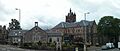
 Kilmacolm centre from the Cross |
|

Kilmacolm
|
|
| Population | 3,930 (2020) |
| OS grid reference | NS365695 |
| • Edinburgh | 56 mi (90 km) |
| • London | 355 mi (571 km) |
| Council area | |
| Lieutenancy area | |
| Country | Scotland |
| Sovereign state | United Kingdom |
| Post town | KILMACOLM |
| Postcode district | PA13 |
| Dialling code | 01505 |
| Police | Strathclyde |
| Fire | Strathclyde |
| Ambulance | Scottish |
| EU Parliament | Scotland |
| UK Parliament |
|
| Scottish Parliament |
|
Kilmacolm is a village and civil parish in the Inverclyde area of Scotland. It's located in the west central Lowlands, on the northern slope of the Gryffe Valley. The village is about 7.5 miles (12 km) southeast of Greenock and 15 miles (24 km) west of Glasgow.
Kilmacolm has about 4,000 people. The wider civil parish covers a large countryside area of 15,000 hectares (150 km²). This area also includes Quarrier's Village, which started as a home for orphans in the 1800s.
The land around Kilmacolm was settled long ago, even in prehistoric times. It became part of a feudal society, where land was divided into estates. The village itself stayed small for a long time. It mainly served nearby farms and was a religious center.
The name Kilmacolm comes from the Scottish Gaelic Cill MoCholuim. This means "church of St Columba." The local church was mentioned in a document from 1225. It stands on the site of a very old religious community from the 5th or 6th centuries.
In the 13th century, Duchal Castle was built nearby. King James IV of Scotland attacked it in 1489. This happened because the Lyle family, who lived there, had supported a rebellion against him. Fighting between noble families in Kilmacolm was common during the Middle Ages. Later, in the 16th and 17th centuries, the area supported the Covenanters. These were religious groups who were outlawed by the Crown.
Kilmacolm changed a lot during the Victorian era. This was especially true after the railway arrived in 1869. Many of the buildings you see today were built between then and World War I. The railway made it easy for people to travel. This helped the village grow as a place where people lived but worked in nearby cities. These cities included Glasgow, Paisley, and Greenock. The village's economy also changed. It moved from farming to providing services for its residents and visitors.
Contents
Kilmacolm's Past: A Look Back


What Does "Kilmacolm" Mean?
Most people believe Kilmacolm gets its name from Scots Gaelic. It means "cell or church of Columba." This refers to an old church dedicated to St. Columba of Iona. This church was likely built in the 6th or 7th century. It was on the same spot as the current parish church. The current church, called the Old Kirk, was mostly built in the 1800s. It includes parts of an older, 13th-century Norman church.
There's a traditional story that St. Columba met St Kentigern (also known as St Mungo) in Kilmacolm. St Mungo is the patron saint of Glasgow. However, some historians think this meeting happened in Glasgow. They suggest that Columba might have simply passed through Kilmacolm on his way.
For a while in the 1700s, Kilmacolm was spelled 'Kilmalcolm'. People thought the name came from one of the Scottish kings named Malcolm. But in 1905, a vote changed the spelling back to 'Kilmacolm'. This was based on research showing the connection to St. Columba was more likely.
Early Life in Kilmacolm
People have lived in Kilmacolm since the Stone Age. Archaeologists have found many items from that time. One important discovery was a farming homestead near Knapps Loch. This was dug up in the early 1960s. Many other signs of early human life have been found in the area.
Several old settlements are listed as ancient monuments by Historic Environment Scotland. These include Bronze Age or Iron Age hut circles and roundhouses. These were likely lightly protected homes. The Knapps homestead is also thought to be from a similar time.
When the Romans came north, they reached Kilmacolm. This area was near the Antonine Wall, which helped defend the Roman Empire's northern border. A Roman road was built through the north of the parish. It led to a fort at Old Kilpatrick. Other forts were built nearby. However, the Romans did not stay in Kilmacolm for a very long time.
There is also a motte (a type of mound for a castle) near the Gryffe Water. It's sometimes called Denniston Motte. It was probably part of an Anglo-Norman wooden castle from the 12th or 13th century. This building likely served as a center for a large estate. It might be linked to the Lyle family, who later owned Duchal Castle. Or it could be linked to the Dennistoun family.
Kilmacolm in the Middle Ages


During the Middle Ages and Early Modern period, Kilmacolm was part of a feudal society. The land was mostly divided into two large estates. These were based at Duchal Castle and Finlaystone House. Two families, the Dennistouns and the Lyles, first owned these estates. Later, other families took over through sales or marriages.
The families often faced problems like religious disagreements. They also sought favor from the King and had conflicts with other families. From the early 1200s, Kilmacolm is mentioned in church records. The church seems to have been dedicated to Saint Columba. These records show that the church in Kilmacolm was connected to Paisley Abbey.
Duchal Castle was built by Ralph de l'Isle (later known as Lyle) in the 13th century. The Lyle family owned it until 1544. Then, the Porterfield family bought it. The Porterfields lived in the castle until 1710. Much of the castle was then taken apart. Its stones were used to build a new home, Duchal House, which still stands today. The ruins of the old castle are still in the parish. The name 'duchal' means 'between two rivers'. This fits the castle's location between Green Water and Blacketty Water.
A famous event in the castle's history was its attack by King James IV of Scotland in July 1489. This happened because the Lyle family had supported a rebellion against the King. The King himself came to the castle. Accounts say the people inside surrendered as soon as they saw the famous Mons Meg cannon being set up. The castle was still fired upon, and one of the King's cannons was named "Duchal."
The Dennistoun family started in the parish in the mid-1100s. The family line ended in 1399 with Sir Robert Dennistoun, who had no sons. His two daughters inherited parts of his estate. They married into new noble families. This created three main estates in Kilmacolm instead of two. The Cunninghams, who later became the Earls of Glencairn, lived at Finlaystone House. The Maxwells later built Newark Castle.
When John Cunningham, 15th Earl of Glencairn died in 1796, his title ended. Finlaystone House was sold to many different owners. Today, it is the home of the chief of Clan MacMillan. In 1668, Sir George Maxwell sold much of his land at Newark to the city of Glasgow. This was for the development of Port Glasgow. Newark Castle is now owned by Historic Scotland.
The Porterfield family bought the Duchal estates from the Lyles in 1544. The Porterfields were strong Covenanters. Duchal was seen as a safe place when being a Covenanter was against the law in the 1600s. Secret religious meetings were held on the estate. One spot was a natural amphitheatre where the Kilmacolm Golf Club's 14th hole is now. Because of their beliefs, the Crown took the estate in 1684. The Porterfield men were arrested. However, the estate was returned after the Glorious Revolution.
The last Porterfield from Duchal was James Corbett Porterfield. He died in 1855 without children. His estate then went to Sir Hugh Shaw-Stewart, 8th Baronet. Later, Lord Maclay bought Duchal House. His family still owns it today.
Kilmacolm in Modern Times

The arrival of the railway in 1869 changed Kilmacolm greatly. It led to a huge expansion during the Victorian era. Before the railway, the village had not changed much for centuries. The railway connected Kilmacolm to Glasgow and Greenock. This made the village a popular place for people to live and commute to work.
Kilmacolm grew very quickly. Many large Victorian and Edwardian houses were built. New attractions like the Hydropathic Hotel appeared. Facilities like banks and piped water also became available. As the village expanded and became more upscale, farming became less important to the local economy. A bit further east on the railway line, William Quarrier's Orphans' Homes opened in the 1870s. This was a community for children until the late 1970s. Now, Quarrier's Village is mostly a residential area.
Kilmacolm slowly gained many services. Victorian schoolhouses were built. A Royal Bank of Scotland branch opened in 1872. Clean piped water arrived in 1878. In the 1920s, a local vote made Kilmacolm a "dry parish." This meant selling alcohol was illegal. The many public houses (pubs) in Kilmacolm closed. The village had no pubs until the 1990s. In 1921, the parish council bought the old Buchanan Arms building. They turned it into a Village Institute, or community centre. It has been used this way ever since.
World War I slowed down local development. About 300 men from the parish joined the British Armed Forces. The village also took in Belgian refugees. During the Second World War, Kilmacolm housed evacuees from Glasgow. Public buildings were used for people who lost their homes in the Greenock Blitz in 1941. One bomb fell in Kilmacolm, causing minor damage. After the war, the hydropathic hotel became a naval hospital. Later, Stakis Hotels bought it and returned it to private use.
Today, the village still looks much like it did during its Victorian and Edwardian boom. Kilmacolm railway station closed in 1983. The old railway track was turned into a cycle path. New houses were built in the late 1900s, especially in the 1960s and 70s. This caused the population to grow. However, Kilmacolm's size has stayed fairly steady in the last ten years. Building on green belt land is now discouraged. This, along with high demand for homes, has led to a shortage of affordable housing in the village.
The Olympic Flame was carried through Kilmacolm on June 8, 2012. This was part of the torch relay for the London 2012 Olympic Games.
How Kilmacolm is Governed


Kilmacolm is the name of a larger civil parish. This includes the village of Kilmacolm, Quarrier's Village, and a big rural area. Civil parishes have been replaced by modern community council areas for local government. Kilmacolm, Quarrier's Village, and the surrounding area are all part of the Kilmacolm community council area.
At a higher level, people in Kilmacolm vote for members of the local government, which is Inverclyde Council. They also vote for representatives in the Scottish Parliament and the Parliament of the United Kingdom.
Images for kids
-
Kilmacolm centre from the Cross
See also
 In Spanish: Kilmacolm para niños
