LaGrange, New York facts for kids
Quick facts for kids
LaGrange, New York
|
||
|---|---|---|

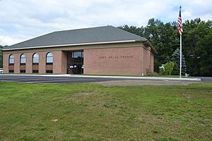
Town Hall
|
||
|
||

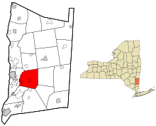
Location of LaGrange, New York
|
||
| Country | United States | |
| State | New York | |
| County | Dutchess | |
| Government | ||
| • Type | Town Council | |
| Area | ||
| • Total | 40.35 sq mi (104.51 km2) | |
| • Land | 39.88 sq mi (103.29 km2) | |
| • Water | 0.47 sq mi (1.22 km2) | |
| Elevation | 322 ft (98 m) | |
| Population
(2020)
|
||
| • Total | 15,975 | |
| • Estimate
(2020)
|
15,975 | |
| • Density | 392.04/sq mi (151.36/km2) | |
| Time zone | UTC-5 (Eastern (EST)) | |
| • Summer (DST) | UTC-4 (EDT) | |
| ZIP code |
12540,12603, 12569
|
|
| Area code(s) | 845 | |
| FIPS code | 36-027-40299 | |
| GNIS feature ID | 0979126 | |
LaGrange (/ləˈɡreɪndʒ/ LƏ-graynj) is a town in Dutchess County, New York, United States. In 2020, about 15,975 people lived there. The town was named after the home of the Marquis de Lafayette, a French hero who helped America during the American Revolutionary War.
Contents
History of LaGrange
The town of LaGrange was first created in 1821. It was formed from parts of the towns of Beekman and Fishkill. At first, it was called "Freedom."
However, there was another town named "Freedom" in Cattaraugus County. To avoid confusion, the name was changed to "LaGrange" in 1828.
Geography and Location
LaGrange is located in the beautiful Hudson Valley region of New York. It covers about 40 square miles (104.5 square kilometers). Most of this area is land, with a small part being water.
LaGrange shares its borders with several other towns:
- To the east: Union Vale
- To the southeast: Beekman
- To the south: East Fishkill and Wappinger
- To the west: Poughkeepsie
- To the north: Pleasant Valley and a small part of Washington
Main Roads and Highways
Three important state highways pass through LaGrange, connecting it to other places.
Taconic State Parkway
The Taconic State Parkway runs north and south through LaGrange. It's a key road for people traveling to and from the town. It connects LaGrange to cities like White Plains (about 51 miles south) and New York City (about 75 miles south).
James Baird State Park is located along this parkway in LaGrange. It's a great place for outdoor activities.
New York State Route 55
New York State Route 55 goes east and west through the middle of LaGrange. You'll find Arlington High School and many shops along this road in the area called Freedom Plains.
In 2014, three traffic circles were added to Route 55 in Freedom Plains. These circles help traffic flow better and make the area look nicer. Route 55 connects LaGrange to the city of Poughkeepsie to the west. To the east, it leads to the town of Pawling. LaGrange is about 11 miles from both Poughkeepsie and Pawling.
New York State Route 82
New York State Route 82 runs diagonally through the town, from southwest to northeast. It links LaGrange to Millbrook in the north and Hopewell Junction in the south.
There are also several county roads that help people get around different parts of the town.
Parks and Fun Activities
LaGrange has some great parks where you can have fun!
Freedom Park
Freedom Park is the biggest park in LaGrange. It has a small lake where you can swim when lifeguards are on duty. There are also special lanes for a swim team. You can buy snacks at the park's concession stand.
The park also has a bandstand and a large outdoor pavilion. There's a small playground for younger kids too. Every summer, the town offers a day camp at Freedom Park.
Other Parks
- Stringham Park: This park has many soccer fields and is located on Stringham Road in the western part of town.
- James Baird State Park: This state park offers a golf course, a playground, and trails for hiking and biking.
Population and People
| Historical population | |||
|---|---|---|---|
| Census | Pop. | %± | |
| 1830 | 2,044 | — | |
| 1840 | 1,851 | −9.4% | |
| 1850 | 1,941 | 4.9% | |
| 1860 | 1,850 | −4.7% | |
| 1870 | 1,774 | −4.1% | |
| 1880 | 1,745 | −1.6% | |
| 1890 | 1,463 | −16.2% | |
| 1900 | 1,304 | −10.9% | |
| 1910 | 1,350 | 3.5% | |
| 1920 | 1,132 | −16.1% | |
| 1930 | 1,210 | 6.9% | |
| 1940 | 1,638 | 35.4% | |
| 1950 | 2,280 | 39.2% | |
| 1960 | 6,079 | 166.6% | |
| 1970 | 10,902 | 79.3% | |
| 1980 | 12,375 | 13.5% | |
| 1990 | 13,274 | 7.3% | |
| 2000 | 14,928 | 12.5% | |
| 2010 | 15,730 | 5.4% | |
| 2020 | 15,975 | 1.6% | |
| U.S. Decennial Census | |||
In 2020, the population of LaGrange was 15,975 people. The town has grown quite a bit over the years. For example, in 1950, only 2,280 people lived here.
In 2000, about 28.5% of the people in LaGrange were under 18 years old. The average age was 38 years. Most households were made up of married couples.
Well-Known People from LaGrange
Some notable people who have lived in LaGrange include:
- Pierre A. Barker: A former mayor of Buffalo, New York.
- John Gatins: A screenwriter who was nominated for an Oscar.
- Isaac R. Harrington: Another former mayor of Buffalo, New York.
- Anthony Van Wyck: A former member of the Wisconsin State Senate.
Communities and Areas in LaGrange
LaGrange is made up of several smaller communities and hamlets:
- Arthursburg – A hamlet at the southern edge of the town, named after former U.S. President Chester A. Arthur.
- Billings – A hamlet located north of LaGrangeville.
- Freedom Plains – A hamlet found northwest of LaGrangeville.
- James Baird State Park – A large state park in the northern part of the town.
- LaGrangeville (or La Grangeville) – A hamlet in the southeastern part of the town. This is the largest part of LaGrange, with over 8,200 people living there in 2014.
- Manchester Bridge – A hamlet in the western part of the town.
- Moores Mill – A location in the northeastern part of the town.
- Noxon – A location west of LaGrangeville.
- Rombout Ridge – A location near the western town line.
- Titus – A hamlet near the western town line.
Schools in LaGrange
The Arlington Central School District serves the students of LaGrange.
- Arlington High School
- LaGrange Middle School
Several elementary and intermediate schools of the district are also located in LaGrange.
See also
 In Spanish: LaGrange (Nueva York) para niños


