
Lamoille County, Vermont facts for kids
Quick facts for kids
Lamoille County
|
|
|---|---|

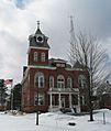
Lamoille County Courthouse in Hyde Park
|
|

Location within the U.S. state of Vermont
|
|
 Vermont's location within the U.S. |
|
| Country | |
| State | |
| Founded | 1836 |
| Named for | Lamoille River |
| Shire Town | Hyde Park |
| Largest town | Morristown |
| Area | |
| • Total | 464 sq mi (1,200 km2) |
| • Land | 459 sq mi (1,190 km2) |
| • Water | 4.9 sq mi (13 km2) 1.1%% |
| Population
(2020)
|
|
| • Total | 25,945 |
| • Density | 55.92/sq mi (21.589/km2) |
| Time zone | UTC−5 (Eastern) |
| • Summer (DST) | UTC−4 (EDT) |
| Congressional district | At-large |
Lamoille County is a county located in the state of Vermont in the United States. In 2020, about 25,945 people lived there. It is the third-smallest county in Vermont by population.
The main town where the county government is located is Hyde Park. However, Morristown is the largest town in the county and its main business area. Lamoille County was created in 1835 from parts of other nearby counties. It was officially set up the next year.
Contents
History
Long, long ago, during the Ice Age, this whole area was covered by a thick layer of ice, about a mile deep! As the ice slowly melted, a large body of water called Lake Stowe formed. When all the ice was gone, the water from this lake flowed away through the valley of the Lamoille River.
For a very long time, the Abenaki people, who spoke an Algonquian language, lived here. They were the first inhabitants. When French explorers and traders came from what is now Canada, they started trading with the Abenaki. Some French people also settled here, coming down from Quebec. They were the ones who named the Lamoille River.
Later, the French and Abenaki became allies. They sometimes fought against the English colonists who were settling in the southern New England areas. For many years, there was no clear border, and people could travel freely through this region.
After the American Revolutionary War, people from other parts of New England and French-Canadians from across the border started settling in Lamoille County in the 1800s. Some of them started small farms. Others came to work in an asbestos mine on Belvidere Mountain, which operated for many years. Over time, people learned more about safety when working with certain materials.
From the 1900s to Today
Mining continued in the 20th century. Later, people understood more about how certain materials could affect health.
In 1972, Lamoille Community College became part of the Vermont State Colleges system. It was then renamed the Community College of Vermont.
In 2008, the state looked into health records from 1995 to 2006. They found that people who worked in the former asbestos mine had health issues related to their jobs. However, a revised study in 2009 found that people living near the mines were not at a higher risk of these health problems than anyone else in Vermont. This showed that the issues were mainly related to working directly in the mine.
In 2020, a study suggested that Lamoille County might be one of the safest counties in the U.S. when it comes to problems caused by climate change. This includes things like rising sea levels, wildfires, and extreme heat.
Geography
Lamoille County covers a total area of about 464 square miles. Most of this (459 square miles) is land, and a small part (4.9 square miles) is water. It is the second-smallest county in Vermont by land area. It is also one of only two counties in Vermont that does not share a border with another state or with Canada.
Interestingly, Lamoille County is the only county in Vermont that does not have a U.S. Route passing through it. However, all ten towns in Lamoille County are served by Vermont state routes.
Neighboring Counties
- Orleans County — to the northeast
- Caledonia County — to the east
- Washington County — to the south
- Chittenden County — to the west
- Franklin County — to the northwest
Population Information
| Historical population | |||
|---|---|---|---|
| Census | Pop. | %± | |
| 1840 | 10,475 | — | |
| 1850 | 10,872 | 3.8% | |
| 1860 | 12,311 | 13.2% | |
| 1870 | 12,448 | 1.1% | |
| 1880 | 12,684 | 1.9% | |
| 1890 | 12,831 | 1.2% | |
| 1900 | 12,289 | −4.2% | |
| 1910 | 12,585 | 2.4% | |
| 1920 | 11,858 | −5.8% | |
| 1930 | 10,947 | −7.7% | |
| 1940 | 11,028 | 0.7% | |
| 1950 | 11,388 | 3.3% | |
| 1960 | 11,027 | −3.2% | |
| 1970 | 13,309 | 20.7% | |
| 1980 | 16,767 | 26.0% | |
| 1990 | 19,735 | 17.7% | |
| 2000 | 23,233 | 17.7% | |
| 2010 | 24,475 | 5.3% | |
| 2020 | 25,945 | 6.0% | |
| U.S. Decennial Census 1790–1960 1900–1990 1990–2000 2010–2018 |
|||
2010 Census Details
In 2010, there were 24,475 people living in Lamoille County. The population density was about 53 people per square mile. Most of the people (96.7%) were white. About 0.6% were black or African American, 0.5% were Asian, and 0.4% were American Indian. About 1.3% of the population was of Hispanic or Latino origin.
There were 10,014 households in the county. About 30.6% of these households had children under 18 living with them. The average household had 2.37 people. The average age of people in the county was 39.7 years old.
Education

Northern Vermont University-Johnson is a college located in Johnson, within Lamoille County. It started way back in 1828 as Johnson Academy. It was one of the first colleges to join together to form the Vermont State College system.
The Community College of Vermont (CCV) also has a campus in Morrisville, which is in Lamoille County.
Communities
Towns
- Belvidere
- Cambridge
- Eden
- Elmore
- Hyde Park (where the county government is)
- Johnson
- Morristown
- Stowe
- Waterville
- Wolcott
Villages
Census-Designated Places
- North Hyde Park
- Stowe
- Wolcott
Unincorporated Communities
- Belvidere Center
- Eden Mills
- Moscow
Images for kids
-
Lamoille County Courthouse in Hyde Park
See also
 In Spanish: Condado de Lamoille para niños
