
List of lakes named McArthur facts for kids
McArthur Lake, also known as MacArthurs Lake or MacArthur's Lake, is a name given to several lakes across Australia, Canada, and the United States. These lakes are found in different environments, from national parks to agricultural areas, and are used for various activities like fishing and boating. Let's explore some of these interesting lakes!
Contents
McArthur Lakes in Australia
In Australia, you'll find a lake called MacArthur's Lake in Victoria. This is a small lake that changes with the seasons. It's part of a unique area called the Raak Plain boinka. During January, the water level can be very low, sometimes just a few centimeters below the lake bed. The water in this lake is very salty, and it gets even saltier as the water evaporates, especially from July to September.
McArthur Lakes in Canada
Canada has many lakes named McArthur, spread across several provinces.
British Columbia
In British Columbia, there's a beautiful lake called Lake McArthur located in the famous Yoho National Park. This lake is about 1.5 kilometers (about 1 mile) long and is quite deep, reaching 85 meters (about 279 feet) at its deepest point. It's a stunning spot for nature lovers.
Northwest Territories
Further north, in the Northwest Territories, you'll find McArthur Lake. This lake is part of the Taltson River system. It stretches about 12 miles (about 19 kilometers) from east to west. It's believed that this is the lake explorer Samuel Hearne once called "Clowey Lake."
Nova Scotia
Nova Scotia is home to a few lakes with the McArthur name.
Inverness County
One MacArthurs Lake is in Inverness County, just west of Big Brook Road. It flows into Big Brook. A railway line runs along its eastern side, making for a scenic view. This lake sits at an elevation of 111 meters (about 364 feet) above sea level.
Cape Breton Regional Municipality
Another MacArthurs Lake is in the Cape Breton Regional Municipality. It's located north of MacMullin Lake and is connected to it by a small channel. It's also south of Figure of Eight Lake and west of Grand Mira North Road. People have described it as a "beautiful pond." Like MacMullin Lake, it's part of the Framboise River watershed and is at an elevation of 31 meters (about 102 feet).
Pugwash River
An old report from 1884 mentions a McArthur's Lake on the Pugwash River in Nova Scotia. This lake was created by a dam to power McArthur's saw mill. Unfortunately, the dam made it hard for fish to swim upstream, and the lake faced problems with sawdust pollution from the mill. This shows how human activities can impact natural environments.
Ontario
In Ontario, there's a McArthur Lake located about 40 kilometers (about 25 miles) south of the city of Timmins. This lake has a rocky shoreline, three main bays, and thirteen islands. The western side of the lake is popular, with more than 20 camps and cottages. It's a great place for outdoor activities like kayaking, boating, and fishing. Anglers often catch fish like walleye and northern pike here.
Quebec
Quebec also has a couple of lakes named McArthur.
Lac McArthur (Val-des-Monts)
One is Lac McArthur in the Outaouais region. This lake is fed by the Rivière Blanche, which flows from Lac Saint-Pierre. The water from Lac McArthur then empties into Lac Grand to the southeast.
Lac McArthur (Denholm)
Another Lac McArthur is also in the Outaouais region, near Denholm and the Réserve écologique André-Linteau. This lake is at a higher elevation of 333 meters (about 1,093 feet).
Saskatchewan
Saskatchewan features a few McArthur Lakes.
McArthur River uranium mine
Sometimes, the name "McArthur Lake" is used to refer to the area around the McArthur River uranium mine, which is operated by Cameco. However, it's important to know that this "lake" isn't officially recognized as a lake in the Gazetteer of Canada.
Pleasantdale
There's a McArthur Lake located east of Pleasantdale, Saskatchewan. The land around this lake is mainly used for farming.
Pelican Narrows
Another McArthur Lake is about 30 kilometers (about 19 miles) east of Pelican Narrows. It sits at an elevation of 328 meters (about 1,076 feet) and is close to Attitti Lake. The water from McArthur Lake, Robbestad Lake, and the northern part of Kakinagimak Lake all flow north into the Nemei River, which then joins the Churchill River.
McArthur Lakes in the United States
The United States also has lakes named McArthur.
Idaho
In Idaho, you'll find McArthur Lake on Deep Creek. The areas along the lake's edge, known as riparian zones, are protected as part of the McArthur Lake Wildlife Management Area. This area covers 1,207 acres (about 488 hectares) and helps protect the local wildlife.
North Carolina
North Carolina has two lakes named McArthur.
Goldsboro
One is a small McArthur Lake located in Goldsboro, North Carolina.
Fort Bragg
The other is McArthur Lake at Fort Bragg, North Carolina. This lake is about 1,137 feet (about 347 meters) long and covers 29 acres (about 12 hectares). It has an average depth of about 10 feet (about 3 meters). Many types of fish live here, including largemouth bass, bluegill, redear sunfish, warmouth, flier, pickerel, and bullhead catfish. It's a popular spot for fishing.
Gallery
-
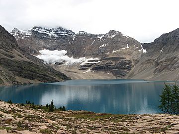
Lake McArthur in Yoho National Park, Canada.
-
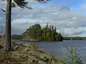
McArthur Lake in Ontario, Canada.
-
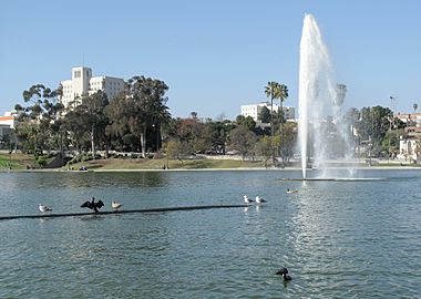
A lake in MacArthur Park, Los Angeles, USA.


Sources
 |
This article includes a list of lakes that share the same name (or similar names). If an internal link incorrectly led you here, you may wish to change the link to point directly to the intended lake article. |
__DISAMBIG__
